IMPORTANT UPDATE Thursday 26th January 2023: The State Park has announced that Skyline Trail is closed with immediate effect due to hazardous conditions above the State Park boundary (5800 ft elevation). There is no planned reopening date at this time. For those that are unclear, the Skyline Trail is the first segment of the C2C (“Cactus to clouds”) from Palm Springs up to Grubb’s Notch (Long Valley).
WEATHER UPDATE Thursday 26th January 2023: Wild Santa Ana (north-east) winds today in the San Jacinto mountains have included gusts of 69 and 73 mph early this morning at automated stations at each end of Bonita Vista Road. On the north side, a location just south-east of Banning in San Gorgonio Pass recorded a gust of 92 mph. Hikers should anticipate new treefall hazards in trails – we have already found one major new one on the Ernie Maxwell Trail – and also that tracks in snow may have been obscured by windblown drifting powder. The storm forecast for 29th-30th January looks less dramatic than previously predicted, with the high country largely above the storm (only an inch of snow forecast), and only 2-4 inches now expected at the elevation of Idyllwild.
—————————–
The previous Report (available here) summarized the conditions following the multiple storm event of 14th-17th January. My blogging throughout the storms gave more day-to-day detail and is available here. Since then Idyllwild had a very light dusting (<0.25 inch) of snow on Friday 20th, but the high country was above the cloud and unaffected.
Early on Monday 23rd January I ascended San Jacinto Peak via the east side (Devil’s Slide, Wellman, and Peak trails) that I had broken last Wednesday 18th, and descended the west side via (more-or-less) Deer Springs Trail. A strong and bitterly cold NNE wind made conditions interesting, with large parts of the broken tracks filling in overnight with spindrift (and wind blown ice blocks), so I found myself breaking lengthy sections of trail yet again. This started as low as Devil’s Slide Trail and continued all morning. On the plus side, as I had hoped, the cold meant that the exposed snow slopes from 9200 ft and above were largely firm and icy (example photo below). Consequently I put on crampons at Wellman’s Cienega, keeping them on all day until low down on Deer Springs Trail. Although I carried snowshoes it would have been risky to try to use them on the icy traverses.
On Friday 20th I broke South Ridge Trail to Tahquitz Peak. I put in a posthole track the entire way up, but crampons (with an ice axe) were essential at that time on the upper switchbacks above about 8300 ft due to the typical steeply angled ice obscured underneath 6-12 inches of powder (photos below).
Details of snow depths measured at various locations on the trail system are given at the foot of this posting. Note however that snow depth itself is rarely indicative of the difficulty (or otherwise) of hiking a particular trail. Although the high country currently has its deepest snow accumulation in almost four years, since March 2019, this winter nevertheless remains well below the average for snowfall in the San Jacinto mountains to late January.
Be prepared for trails above about 8000 ft (perhaps lower in places) completely or largely obscured by moderate to deep snow. Very cautious navigation is strongly recommended everywhere.
Current forecasts suggest that there may be significant snowfall on Sunday 29th-Monday 30th January at all elevations, but some warming and steady snow melt likely on either side of that date. Fresh snowfall, melting, and freeze/thaw cycles will all combine to change trail conditions and potentially the preferred equipment for the terrain over the next week or two.
With some melting already underway and compaction caused by freeze-thaw cycles and hiker traffic, conditions will deteriorate for snowshoeing over the next few days, especially on more heavily traveled trails below 9000ft. Nevertheless, snowshoes will be valuable anywhere off trail above about 8000ft for the foreseeable future, and on trail where tracks have not yet been broken. They may become increasingly useful if conditions warm sufficiently for snow to become soft above about 9000 ft, especially on sunny slopes and afternoons.
In addition to snowshoes, and as conditions change, spikes are strongly recommended for the foreseeable future everywhere above about 6000ft. They will be especially valuable on well-consolidated tracks over the coming weeks before they clear of snow (e.g., Devil’s Slide, Ernie Maxwell, Deer Springs trails, at least), on colder mornings when conditions are icy, and for descending. They are not however required, depending upon your comfort level hiking on shallow variable snow, potentially mixed with slushy and icy patches.
As described above, crampons (always in conjunction with an ice axe) are currently recommended on certain moderate and higher angle slopes, at a minimum on the Peak Trail above Wellman Divide, the Wellman Trail, and uppermost South Ridge Trail, on both flanks but especially on the north face of Tahquitz Peak.
Hikers should be prepared for temperatures below freezing in the high country, and well below freezing when considering wind chill effects (see below for my recent weather observations from San Jacinto Peak).
Avalanche risk in the high country is currently minimal due to snow depths and conditions, with the exception of the traditionally unstable north face of San Jacinto Peak which avalanches to some extent every winter.
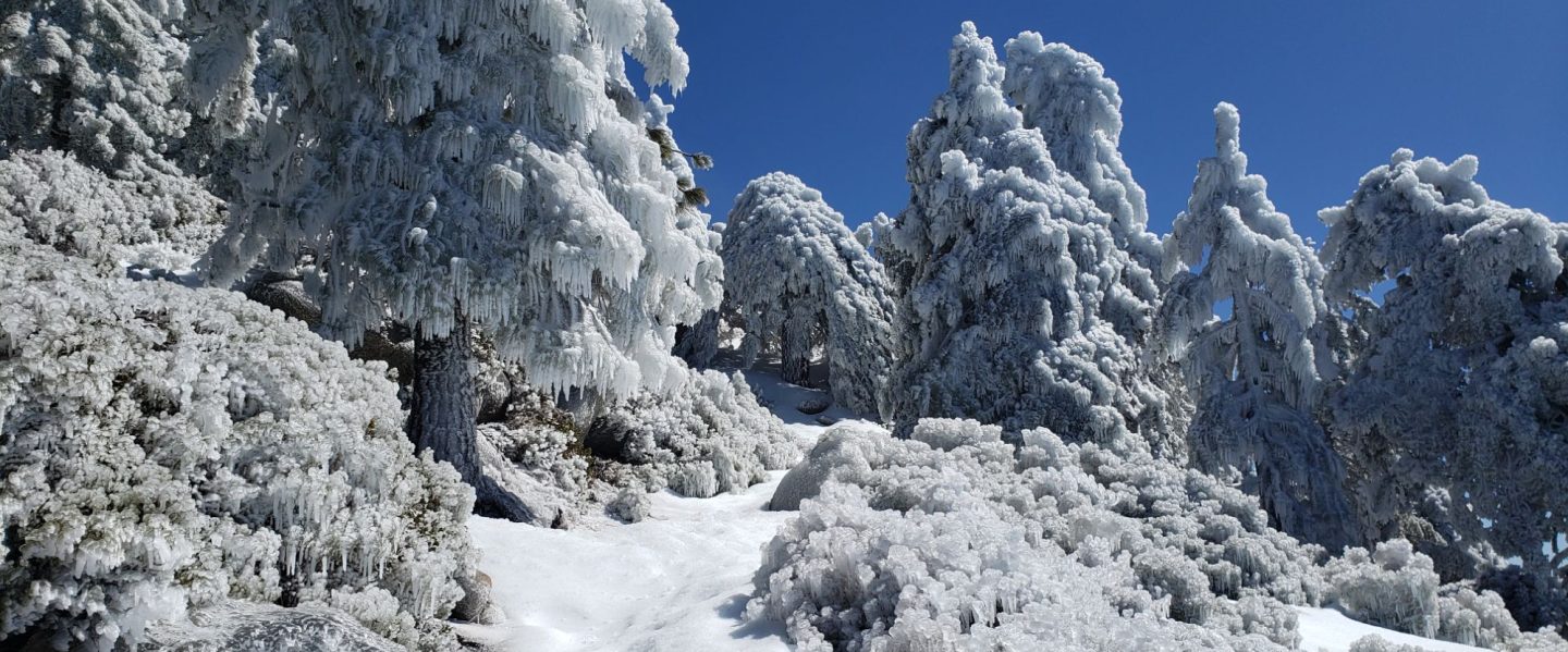
As always after storms in the San Jacinto range be aware of considerable ice fall from overhead trees. Sadly this phenomenon has become much more of a factor in recent years with freezing rainfall (rather than snow) occurring at higher elevations at higher frequency with much warmer weather systems. This rain produces huge masses of ice in the trees, including chunks I have estimated as weighing 40-100 lb this winter, which can dislodge dramatically once direct sunlight warms the trees.
Hikers should be prepared for temperatures below freezing in the high country, and far below freezing when considering wind chill effects (see below for my recent weather observations from San Jacinto Peak).
The USFS gate at Humber Park remains closed. Even when the gate is closed there are nine legal parking spaces below the locked gate (which still require an Adventure Pass or equivalent to be displayed). If there are “Road Closed” signs further down – often the case at weekends and holidays when snow is present – then those nine spaces are also unavailable for legal parking.
South Ridge Road (5S11), Dark Canyon Road (4S02, the access to Seven Pines Trail), and Santa Rosa Truck Trail (7S02) are currently closed to vehicle traffic, as is Black Mountain Road at the gate 1.7 miles up from Highway 243.

WEATHER
After an interesting month of weather, the remainder of January into February is forecast to be somewhat more settled. In general temperatures are expected to warm to above average into next month at all elevations, especially at the highest elevations in the first week of February. Melting is expected to be steady and start to accelerate into February, but freeze/thaw cycles, compaction, and refreezing overnight may ultimately combine to produce very icy conditions.
That said, a moderate snow storm is forecast for Sunday 29th to Monday 30th January, with up to six inches of snow forecast above about 5000 ft, possibly up to 12 inches above 10,000 ft, and a freeze level down to 4000 ft.
At San Jacinto Peak (10,810ft/3295m) on Monday 23rd January 2023 at 1010 the air temperature was 11.1°F (-11°C), with a windchill temperature of -16.2°F (-26°C), 47% relative humidity, and a bitter NNE wind sustained at 20 mph gusting to 27.7 mph.
At the Peak on Wednesday 18th January 2023 at 1115 the air temperature was 16.8°F (-8°C), with a windchill temperature of -3.6°F (-20°C), 27% relative humidity, and a frigid NNW wind sustained at 10 mph gusting to 25.8 mph.
At the Peak on Sunday 15th January 2023 at 0750 the air temperature was 17.8°F (-8°C), with a windchill temperature of -5.6°F (-21°C), 100% relative humidity, and a wild SW wind sustained at 19 mph gusting to 30.2 mph.

TRAIL CONDITIONS
All trails above about 5500 ft are currently snow-covered. Snow cover is shallow up to about 7000 ft, but relatively heavy above 8000 ft. Melting on sun-exposed slopes is well underway, e.g., on lower South Ridge and Deer Springs trails.
Note that tracks discussed here may become obscured by heavy drifting of snow from strong winds combined with extensive ice fall from trees overhead.
Devil’s Slide Trail has a relatively well-traveled and compacted track to Saddle Junction in place already. Note that there are about a dozen stream crossings and sections of the trail with water flowing in them, at times for tens of feet. Waterproof or highly water resistant footwear is recommended. Spikes are not needed yet, but that will change soon with increasing compaction and freeze/thaw cycles. There are two new treefall hazards to pass on the upper trail.
Ernie Maxwell Trail [checked 23rd and 26th January] has good tracks to follow along its entire length, through the shallow icy snow (still >90% snow cover). Spikes are strongly recommended as the snow is now hard, compacted and very icy in places. Three significant trees are now down across the trail, including two major hazards (one new in gale force winds on 26th) that are not easy to hike around both roughly halfway along the trail.
South Ridge Trail has been broken from the top of South Ridge Road to Tahquitz Peak with a simple posthole track. Spikes at least, but preferably crampons, are required for the uppermost switchbacks (see photo below).
The 0.4 mile section of South Ridge Trail between Chinquapin Flat/PCT and Tahquitz Peak [checked 20th January] has no steps to follow through the steeply angled ice with overlying deep snow. These icy slopes are notoriously treacherous. Currently crampons, always with an ice axe, and advanced knowledge of how to use this equipment, are required. Snowshoes are not advisable due to the angle of the icy snow.
On 23rd January I saw posthole tracks from Saddle Junction that head down the start of the Caramba Trail, the start of Willow Creek Trail, and following the PCT southbound toward Chinquapin Flat, but I have no further details at this time.
The Wellman Trail track was disappearing under spindrift as I re-broke it on Monday 23rd. The route does not follow the established trail for the most part, and steepens considerably as it nears Wellman Divide. Crampons (or perhaps spikes or snowshoes on some days) are recommended.
The Peak Trail track is also partially disappearing under fresh spindrift (photos below). The route largely follows the established trail, but hikers coming from Long Valley over the weekend either did not find or follow my broken trail from last week, so in sections the route is unusual. Crampons are recommended for the traversing slopes.
The East Ridge Trail from near Miller Peak to San Jacinto Peak has multiple tracks, all of which were disappearing under fresh spindrift when I ascended that way on Monday 23rd.
Deer Springs Trail has a broken track to follow all the way to San Jacinto Peak. A well-traveled snowshoe track is in place up to Strawberry Junction. From there to the top of Marion Mountain Trail the route is a lightly-traveled posthole track. From the top of Marion, the route is well-traveled but pretty uneven, up into Little Round Valley. It does not accurately follow the established trail route in significant sections but is navigable. Through LRV and up to San Jacinto Peak, there are at least three tracks (two posthole, one snowshoe), none of which attempt to follow the trail route, and all are steep and very direct. There are five new major treefall hazards, plus many other limbs and branches, across the trail between the Suicide Rock junction and the Marion Mountain Trail junction.
Marion Mountain Trail has a well-traveled snowshoe track to follow along its entire length. Note that near its junction with Deer Springs Trail, the route was not close to the established trail, so cautious navigation may be needed.
There was no evidence of hiker tracks on Fuller Ridge Trail or Seven Pines Trail as of Monday 23rd January.

SNOW DEPTHS measured on 23rd January 2023 (unless otherwise indicated) are as follows. The first number is the current average total snow depth at that location, followed in parentheses where known by the maximum depth so far this winter immediately following the latest storm sequence on 14th-17th January 2023. Note that average depth is given; due to strong winds accompanying storms there is extensive drifting. Altitudes are approximate.
San Jacinto Peak (10810 ft): 42 inches (45-48 inches), drifted to 60 inches in places, especially on East Ridge.
Little Round Valley (9800 ft): 45 inches, heavily drifted
Wellman Divide (9700 ft): 40 inches (45 inches)
Annie’s Junction/PCT Mile 180.8 (9070 ft): 44 inches (45-48 inches)
Tahquitz Peak (8836 ft): 25 inches, heavily drifted to 40 inches in places (measured 20th January)
Seven Pines Trail junction with Deer Springs Trail (8700 ft): 36 inches
Long Valley (8600 ft): 20 inches (24 inches)
Strawberry Junction/PCT Mile 183 (8100 ft): 15 inches
Saddle Junction/PCT Mile 179 (8070 ft): 19 inches (21 inches)
Suicide Rock Trail junction with Deer Springs Trail (6950 ft): 1-3 inches
Devil’s Slide trailhead at Humber Park (6550 ft): 2-4 inches (5-6 inches)
Idyllwild (at 5550 ft): 0-2 inches (3 inches)
Thank you for taking the time to read this. While all time and labor is volunteered, the San Jacinto Trail Report uses small private donations to help cover costs. Every year seems to have its unique challenges, and it is already clear that 2023 will be no exception. Your contribution keeps the Report available to all, free from advertising or paywalls, and independent from agencies. If you have found this Report useful, please consider using this link to the Donate page. Zelle, Venmo, and PayPal are all options. Thank you so much for your support.


