
I have been averaging four hikes per week to San Jacinto Peak, via as many different routes as possible, plus most other major trails around the high country such as Willow Creek, South Ridge, and Caramba. Just 32 days since leaving ICU, Anabel accompanied me into the high country for the first time today with no apparent difficulty (for those unfamiliar with the full story of how our dog survived a neurotoxic rattlesnake bite in the San Jacinto high country, it is available here).
There are several current missing persons cases in and around the San Jacinto mountains. Only one, Roy Prifogle, was known to be hiking public trails at the time of his disappearance. Anyone with any relevant information should contact Riverside County Sheriffs Department.
Be rattlesnake and bear aware. As described last week potentially hazardous wildlife is active at present. As always, if you respect them, they will respect you.
Black Mountain Road reopened on 20th June, having been graded through to the Fuller Ridge campground. However Boulder Basin campground will remain closed all year.
Palm Springs Aerial Tramway is closed indefinitely (since 12th March) due to the coronavirus crisis. The Tram has brought forward their normal September maintenance program into August this year, to allow for a theoretical reopening date of 1st September. However that requires a variety of approvals that will likely depend on significant improvement of the coronavirus crisis.
Permits are required for hiking and camping in Mount San Jacinto State Park, see their website for details. The U.S. Forest Service ranger station in Idyllwild remains closed due to the coronavirus crisis. Although Forest Service wilderness camping and hiking permits can be issued if requested, they are currently not required. USFS campgrounds are now open, except those discussed elsewhere in this post.

WEATHER Starting today, four days of below average temperatures will provide welcome relief from the heat. By Sunday 9th August, temperatures are forecast to return to summer seasonal averages, before moving well above average starting about Wednesday 12th. There is no precipitation in the forecast. Fire risk remains severe.
At San Jacinto Peak (3295m/10,810ft) on Wednesday 5th August 2020, at 0805 the air temperature was 48.8°F (9°C), with a windchill of 41.4°F (5°C), 22% relative humidity, and a steady due West wind sustained at 12 mph gusting to 17.1 mph.
At the Peak on Monday 3rd August 2020 at 0745 the air temperature was 55.5°F (13°C), with a windchill of 52.9°F (12°C), 18% relative humidity, and a light but steady WNW wind sustained at 5 mph gusting to 8.5 mph.
The warmest morning I have recorded at San Jacinto Peak so far in 2020 was on Monday 20th July, when at 0835 the air temperature was 59.7°F (15°C), with no discernible windchill, 31% relative humidity, largely calm with an occasional NE breeze gusting to 2.7 mph.
TRAIL CONDITIONS
All trails have been clear of snow since early June. Many trails have new treefall hazards from this past winter, passable for hikers but not for stock. Some are described in detail below, others include: PCT south of Red Tahquitz (approx. PCT Miles 173-175), PCT between Strawberry Cienega and Deer Springs camp (Miles 182-185), Fuller Ridge Trail near its northern end (PCT Miles 189.1-190.2), Spitler Peak, Cedar Spring, and Apache Spring trails.
Willow Creek Trail has nine tree hazards on State Park land between the USFS boundary and Hidden Divide from this past winter. Fourteen additional trees on Forest Service land, and two in the State Park, have been cleared since late May. As reported previously, the challenging whitethorn on this trail has now been removed.
Seven Pines Trail has been very lightly traveled since November 2018. There are 25 treefall hazards on the trail, almost all in the upper State Park section of trail, based on multiple June 2020 surveys. Very cautious navigation is recommended for those unfamiliar with this trail. The Forest Service closure of Dark Canyon Road is expected to continue into 2021, so there is currently no vehicular access to Seven Pines trailhead.
The Pacific Crest Trail remains open at the rockslide just north of Antsell Rock (Mile 172.5). USFS plans for removal of the rockslide have been delayed due to the coronavirus crisis. The video report (available here) can be useful for deciding whether to hike around the rockslide or take an alternate route.
Forest Service temporary signage indicates that the Caramba Trail from near Reeds Meadow through Laws Camp and on to Caramba, and the Cedar Trail from Willow Creek Trail to Laws, are “not maintained”. In reality both trails no longer exist. Both are so heavily overgrown I advise hikers do not attempt to follow them. Many experienced hikers have reported getting lost in this area since summer 2019. An informal use trail to Laws is much more direct and avoids all of the challenging bush-whacking of the unmaintained trails (some local hikers have dubbed it the “King Trail”). It leaves the Willow Creek Trail exactly 1.0 mile from Saddle Junction (0.46 mile from the Skunk Cabbage turning), descending largely on established deer trails for 1.2 miles, roughly paralleling Willow Creek just to its south. Be advised that it is an indistinct use trail, becoming less obvious as it nears Laws (by which time Willow Creek is close by on your left hand side, so navigation is not a challenge). From Laws east to Caramba the route of the original Caramba Trail is relatively easy to follow (for those who were familiar with this trail prior to the 2013 Mountain Fire). Nevertheless, cautious navigation is still advised.
WATER STATUS: Eastern slope
The Round Valley pipe is flowing again. Flow has periodically been redirected to the CCC/ACE camp in Long Valley and water pressure can be insufficient to also flow at the pipe. This water source is inconsistent and should not be relied upon. The nearby Round Valley creek is now dry.
The small creek in Tamarack Valley is barely flowing and will likely dry up this month.
Both the northern and southern springs at Wellman’s Cienega are flowing gently. These are the sources for Willow Creek, which is flowing well where it crosses the Willow Creek Trail.

Tahquitz Creek is flowing at the northern end of Little Tahquitz Meadow. It is also flowing further upstream at its source (known locally as Grethe Spring) where it crosses the PCT (approx. PCT Mile 177). The small creek in Tahquitz Valley continues to flow gently.
Candy’s Creek – that flows through Skunk Cabbage Meadow and then crosses the remaining visible section of Caramba Trail near Reeds Meadow – is currently flowing steadily.
WATER STATUS: Western slope
Ephemeral creeks, such as those along Marion Mountain Trail and on Deer Springs Trail, are now all dry (for filtering at least).
The North Fork of the San Jacinto River is flowing very well where it crosses the Deer Springs Trail and again downstream where it crosses the Fuller Ridge Trail on the PCT (approx. PCT Mile 186.2).
The creek in Little Round Valley is flowing, although at less than half the volume compared to this time last year. The same creek is flowing weakly where it crosses Fuller Ridge Trail (at about PCT Mile 186.4).
Shooting Star Spring (below Little Round Valley but above the North Fork of the San Jacinto River crossing) is flowing well.
The Deer Springs stream crossing at the PCT (approx. PCT mile 185.6) is flowing strongly.
Switchback Spring at PCT Mile 183.5 (about 0.4 miles on the PCT northbound from Strawberry Junction) is flowing gently, but there is not adequate depth in which to filter water.
The little creek at Strawberry Cienega (PCT mile 183.0) is now functionally dry and should not be relied upon for filtering.
On Devil’s Slide Trail, Middle Spring is flowing very gently. Other creeks and springs on this trail have functionally dried up.
On the Ernie Maxwell Trail, the crossing of Chinquapin Creek just below Humber Park is now dry where it crosses the trail, however there are small pools just upslope from the trail (this is an important source of water for the many dogs walked on the Ernie Maxwell).
WATER STATUS: Desert Divide
Live Oak Spring (N 33 37 21, W 116 33 24) Flowing well. The most reliable water source on the Desert Divide.
Cedar Spring (N 33 40 36, W 116 34 35) Flowing well. Easiest access is the trough just upstream from the trail to the campsite.
Apache Spring (N 33 43 11, W 116 37 13) Flowing weakly.
Spitler Peak Trail Descending the trail there are five water crossings. The first two, at 0.9 and 0.95 miles down, cross a tiny side creek which is largely dry and should be ignored. The next crossing, at 1.1 miles down, is Spitler Creek and is the best source of water (currently flowing well). The next two crossings are the same creek, but for obvious reasons it is best to fill up at the highest of the three crossings.
Antsell Rock Creek (N 33 41 52, W 116 39 08) Right by the Spitler Peak Trail trailhead on Apple Canyon Road, Antsell Rock Creek is flowing very well. Just on the upstream side of the road there is excellent access to the creek. Useful if hikers are descending the Spitler Peak Trail.
San Jacinto Trail Report: available for everyone, funded by readers. While all labor and time is volunteered, this Report completely depends on small private donations to cover its direct costs. With a very challenging first half of 2020, every contribution is invaluable. If you have found this Report useful, please consider visiting the Donate page. Thank you.

Hi John,
It’s great to hear Annabel is getting back to normal form. Based on how the events unfolded in Annabel’s snake bite I do believe that miracles can and do happen by the grace of God. I can tell you have a real connection with Annabel and am thankful that you both have more time on and off trail together.
Quick update: I am continuing to section hike of the PCT and just finished the section from Hwy 18 to Cajon pass over the past three days.
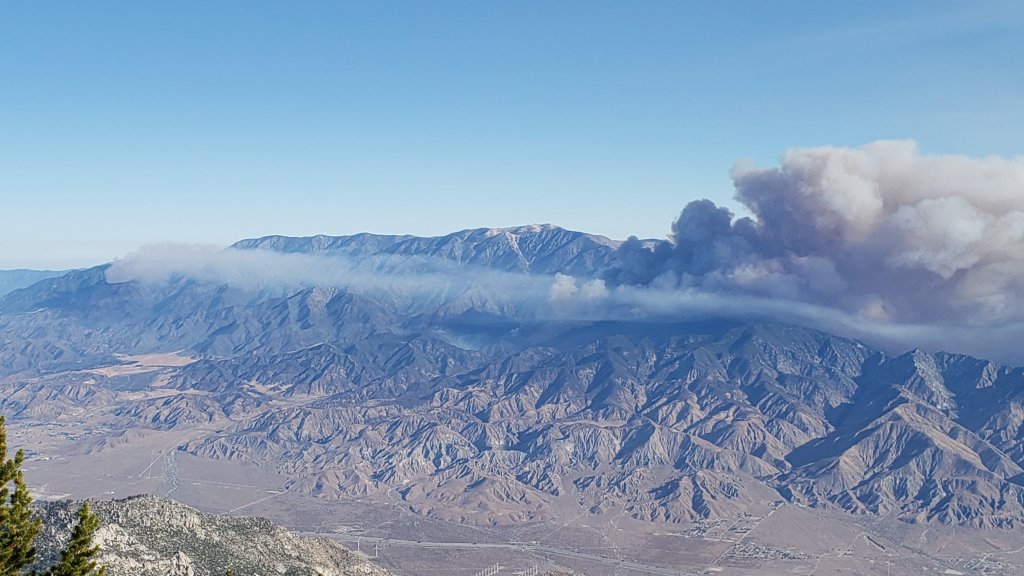
Here is a pic of the smoke generated from the Apple Fire looking from the north side of Big Bear Lake.
James
>>
LikeLike
Thanks James for the positive comments, and good luck on the Trail.
LikeLike
Hi John,
It’s great to hear Annabel is getting back to normal form. Based on how the events unfolded in Annabel’s snake bite I do believe that miracles can and do happen by the grace of God. I can tell you have a real connection with Annabel and am thankful that you both have more time on and off trail together.
Quick update: I am continuing to section hike of the PCT and just finished the section from Hwy 18 to Cajon pass over the past three days.
Here is a pic of the smoke generated from the Apple Fire looking from the north side of Big Bear Lake.
James
>>
LikeLike