I have ascended San Jacinto Peak every day so far this month, by different routes each day. This has included almost all the PCT above 8000′ in the region, the east and west approaches to the Peak, Willow Creek Trail, Round Valley, plus Tahquitz Peak and the Tahquitz area meadows.
The snow has almost gone. What remains is not refreezing at night, and is soft even in the early morning. The few on-trail areas where snow persists are described below.
The status of the rock slide at PCT Mile 172.5 (just north of Antsell Rock) is discussed in detail in a posting from 30th May. A short section of trail either side of this rockslide will apparently be officially closed by USFS imminently. I will update as soon as details are available.
The status of various water sources was updated in the previous report. Most creeks and springs are currently flowing at their best rates in about a decade. Many additional ephemeral water sources also flowing. That said, it is striking how much the flow rates of some (e.g., springs on Devil’s Slide, Wellman’s Cienega) have dropped in recent days.
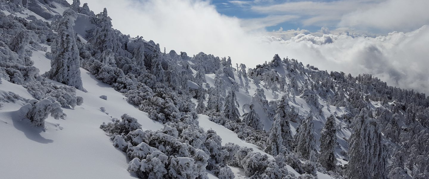
Snow depths are not updated in detail as so little remains, and what does will melt dramatically over the next few days. Northern slopes of all the ten thousand foot peaks still have almost continuous snow cover, as is very obvious looking south from San Jacinto Peak. Snow depth around San Jacinto Peak averages roughly 6″, and about 8″ Little Round Valley, but it is increasingly patchy, with deeper drifts in places, at both locations.
Microspikes are no longer needed anywhere in the San Jacinto high country. Snow is staying soft overnight everywhere, so footwear with decent tread is sufficient for the patches that remain. Traction might be useful (but not essential) for extensive high country off-trail travel. Descending the east ridge of San Jacinto Peak late this morning was a mix of postholing through soft-serve ice cream interspersed with fun glissading on firmer sections.
Hikers should always be prepared for rapidly changing conditions in the high country in summer. Thunderstorms with lightning and precipitation can occur at or near the high peaks even when such storms are not forecast for lower elevations.
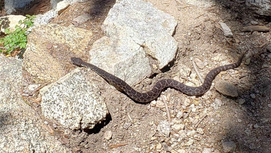
Be rattlesnake aware. Although Southern Pacific Rattlesnakes emerged at mid elevations in April, after a cool May they have just started to appear in the high country. Word around Idyllwild-Pine Cove so far this summer is that they are especially common this year. The San Jacinto form of this species is the second most dangerous animal in the high country (after your fellow human beings). They have a neurotoxic venom, which is considerably more life-threatening than the haemotoxic venom of many lower elevation rattlesnakes. I had my first high elevation observation today.
WEATHER Temperatures will be summer-like for the foreseeable future, with some very slight cooling possible late next week. No precipitation in the forecast.
At San Jacinto Peak (10,810’/3295m) today 6th June 2019 at 1050, the air temperature was 51°F (10°C), with a windchill temperature of 47°F (8°C), 46% relative humidity, and a light West breeze at 5 mph gusting to 7.3 mph.
At the Peak yesterday 5th June 2019 at 0830, the air temperature was 53°F (11°C), with a windchill temperature of 44°F (7°C), 37% relative humidity, and a modest NNE breeze at 6 mph gusting to 10.5 mph.
The last cool day of the season at the Peak was Monday 3rd June, when at 0755 the air temperature was 38°F (2°C), with a windchill temperature of 26.7°F (-3°C), 78% relative humidity, and a cool due North wind of 11 mph gusting to 17.2 mph.
TRAIL CONDITIONS
Trails below about 9600′ are essentially clear of snow, except for a few spots described below. Most higher trails also have only limited snow patches.
Waterproof footwear remains useful on some trails (e.g., Deer Springs, Fuller Ridge) due to multiple stream crossings and considerable water flowing in the trails. It is also valuable in the soft melting snow in many areas, especially after mid-morning.
Pacific Crest Trail is basically clear of snow through the San Jacinto mountains, including Fuller Ridge. Very limited patchy snow cover persists in a couple of areas, e.g., around Miles 181.5 and 189, but these present no challenge.
Deer Springs Trail is clear of snow up to north of the junction with the Marion Mountain Trail (about 8800′). There are only limited snow patches from that elevation to well above the Fuller Ridge Trail turning at about 9700′. Snow is more continuous (40% cover) through Little Round Valley but now only about 10% from there up to just below San Jacinto Peak. The campsites in LRV are now largely snow-free.
Tahquitz Peak trail from the PCT/ Chinquapin Flat is almost completely clear of snow (enough to pass easily without microspikes). There are a couple of extremely minor snow patches, but these have good steps in the soft snow.
East Ridge Trail from near Miller Peak to San Jacinto Peak remains 90% snow-covered, with some drifted areas still 2-3 feet deep. See my comments above about the mix of postholing and glissading.
Round Valley trail to Wellman Divide has about 40% snow cover. In places the tracks do not match the trail and a little care routefinding will still be required for the next few days.
Devil’s Slide, Willow Creek, Marion Mountain, Seven Pines, Ernie Maxwell, High, Long Valley, and Skyline trails are all clear of snow.
Note that as of 5th June, Willow Creek Trail has 27 trees down on the trail between Saddle Junction and Hidden Divide, making it slow going and a little hazardous in places. The relevant agencies have been notified.
South Ridge Road is clear and has been graded, but it requires 4WD very near the top due to mud. South Ridge Trail is clear of snow to Tahquitz Peak, with just a few tiny patches nearer the Peak. Microspikes not required, even for descending.
Black Mountain Road is easily passable through to Fuller Ridge campground. Note that the Boulder Basin and Black Mountain Group campgrounds remain closed. Friday 28th June is the tentative reopening date for Boulder Basin.

One thought on “Snow and trail update 6th June 2019”