UPDATE Saturday 3rd June: the short section of South Ridge Trail on the north side of Tahquitz Peak is now functionally clear of snow. The four tiny patches that remain between Chinquapin Flat and Tahquitz Peak have excellent tracks across them and no spikes or other traction devices are required (photo below).
————————————–
Cooler weather in the last week of May only slowed snowmelt rates slightly, and a return to warm weather forecast for early June will accelerate melting once again. Nevertheless snow conditions in early June will continue to be more reminiscent of early or mid April in a “normal” year of the past decade.
Hiking different routes to San Jacinto Peak multiple times per week facilitates assessment of snow conditions on the trail system around the high country including the highest sections of the PCT in the San Jacinto mountains (Miles 179-181 and 183-185.5). Our daily hikes in between mainly assess other parts of the PCT, side trails and alternates, including, for example, South Ridge Trail every week. Our hike on Tuesday 30th May included all of Seven Pines Trail and a lengthy section of Fuller Ridge Trail, as well as all of upper Deer Springs Trail.
On multiple hikes in recent days I did not require spikes for ascending San Jacinto Peak via the main east and west side routes, with firmer snow given the cooler weather. However on two recent hikes spikes were especially useful for descending the western side via Deer Springs Trail, down to about 8700 ft. Overall spikes continue to be useful in the high country, and some hikers may prefer trail crampons.
Trails above about 8900 ft remain largely obscured by light to moderate snow (lower in places). Trails as low as 8000 ft elevation can have shallow but increasingly patchy snow cover, especially on north-facing slopes. The reliable boot tracks of April and early May have become increasingly scrappy with the widespread but patchy melting of recent weeks. Cautious navigation remains important everywhere.
Details of snow depths measured at various locations on the trail system are given at the foot of this posting. Note however that snow depth itself is very rarely indicative of the difficulty (or ease) of hiking a particular track or trail. For example a firm, well-compacted track across snow several feet deep is often much easier hiking than a poorly defined track across just a few inches depth of angled ice.
Spikes remain very useful for the foreseeable future above about 9000 ft (lower in places) but they may no longer be required depending upon the specifics of the route, the hiker’s comfort level hiking on icy snow, plus the quality of footwear being used. This elevation will continue to move slowly upwards with melting of snow over the next few weeks, but spikes will remain useful throughout June at least in parts of the high country. Spikes tend to be especially helpful for descending even when they are not required for ascending.
Crampons – with hiking poles and/or an ice axe, depending on terrain – are becoming less valuable, but remain potentially useful everywhere above about 9000 ft. Some hikers may find them especially valuable anywhere off-trail in the high country on colder mornings.
Snowshoes can be useful above about 9000 ft for off-trail travel only for the next few weeks when the conditions are warm enough, for example to reach the >10,000 ft peaks that are not connected by well-traveled tracks, on the warmest afternoons.
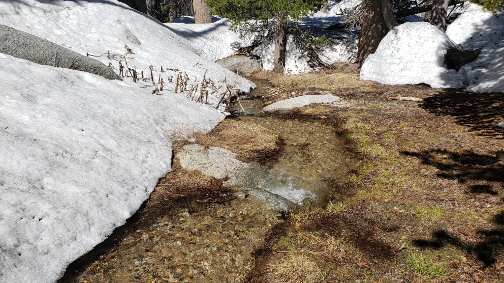
With so much snowmelt, there is a great deal of water in (and under) the trails, and this has also created some tricky stream and river crossings. Lengthy sections of Deer Springs Trail in particular will basically remain ephemeral streams for the next month or two. Appropriate footwear that is at least highly water resistant is strongly recommended. Be especially cautious of the many fragile and potentially dangerous snow bridges across water (e.g., see photo below).
Hikers should anticipate encountering many new treefall hazards on trails, along with considerable amounts of debris, branches, cones, etc. While some of these issues are a consequence of the recent intense winter, most trails in the San Jacinto mountains have been inadequately maintained for years largely due to agency dysfunction, plus some effects of wildfires, the coronavirus pandemic, and climate change.
Trails are steadily being cleared of treefall hazards by volunteers. The Trail Report has cleared South Ridge Trail, and largely cleared Spitler Peak and Seven Pines trails, in the past two weeks. Forest Service volunteers have cut trees from Ernie Maxwell and Devil’s Slide trails since mid May.
Hikers should be prepared for temperatures near freezing in the high country, and below freezing when considering wind chill effects (see below for my most recent weather observations from San Jacinto Peak).
Forest Service roads currently closed to vehicular traffic include Dark Canyon Road (4S02), South Ridge Road (5S11), and Santa Rosa Road (7S02), plus all their various side roads. The USFS gate at Humber Park reopened on Wednesday 19th April. The State Park Stone Creek campground reopened in early May, but Forest Service campgrounds remain closed at this time. Black Mountain Road (4S01) has effectively reopened. The gate 1.7 miles from the highway was vandalized in mid May and the Forest Service have decided to leave it open. The road is in its poorest condition for at least a decade and 4WD and/or high clearance are recommended.
Tahquitz Peak fire lookout reopens for the season on Sunday 4th June. Safe access is now possible from both directions on South Ridge Trail. Black Mountain fire lookout will not reopen until Black Mountain Road (4S01) is graded, which may be later this month.

WEATHER
The last week of May has been pleasantly cool, with temperatures below seasonal and more typical of April, especially at mid elevations. This will continue until 2nd June, after which temperatures will warm markedly. Next weekend (3rd-4th June) will be feel especially warm, but is forecast to be actually only slightly above seasonal for the month, before temperatures drop slightly again the following week. Next week the daytime highs will be near or even somewhat below average, while overnight lows will be at or slightly above seasonal. There is no significant new precipitation in the forecasts.
At San Jacinto Peak (10,810ft/3295m) on Thursday 1st June 2023 at 0750 the air temperature was 41.6°F (5°C), with a windchill temperature of 33.3°F (1°C), 38% relative humidity, and a light ESE wind sustained at 4 mph gusting to 8.8 mph.
At the Peak on Tuesday 30th May 2023 at 0840 the air temperature was 38.5°F (4°C), with a windchill temperature of 28.0°F (-2°C), 18% relative humidity, and a fresh due South wind sustained at 7 mph gusting to 13.4 mph.
At the Peak on Friday 26th May 2023 at 0740 the air temperature was 35.4°F (2°C), with a windchill temperature of 24.6°F (-4°C), 12% relative humidity, and a steady due West wind sustained at 10 mph gusting to 13.6 mph.

PACIFIC CREST TRAIL INFORMATION
The PCT is now largely clear of snow through the San Jacinto mountains. However three relatively short sections remain extensively snow-covered.
The trail is clear from Miles 151 (Highway 74) to about Mile 175. Treefall hazards are a problem on this section but none are insurmountable. I counted at least 94 between Miles 169-175 earlier in May. Apache Peak (Mile 169.5) and other nearby chutes have been clear of snow for several weeks.
Snow cover is about 50% from Miles 175 (Red Tahquitz) to 177.7 (Chinquapin Flat), but with a well traveled track through the extended snow patches and with very little consequential terrain. Some hikers will find that spikes can be useful on this section. The posthole track on Miles 175-178 does not accurately follow the trail route in places.
Snow cover is increasingly patchy and averages only about 30% between Miles 177.7 to Saddle Junction (about Mile 179). The south-facing slope of Miles 179-180 is clear of snow, but from Mile 180 (elevation 8900 ft) to about Mile 181 just past Annie’s Junction snow cover is 90% and the track can be hard to follow in places. Miles 181-184 are functionally clear of snow, and snow cover then becomes extensive (>90%) from Mile 184.5. Spikes can be useful on the snowy parts of this section, but are not required at this time for hikers experienced with snow travel.
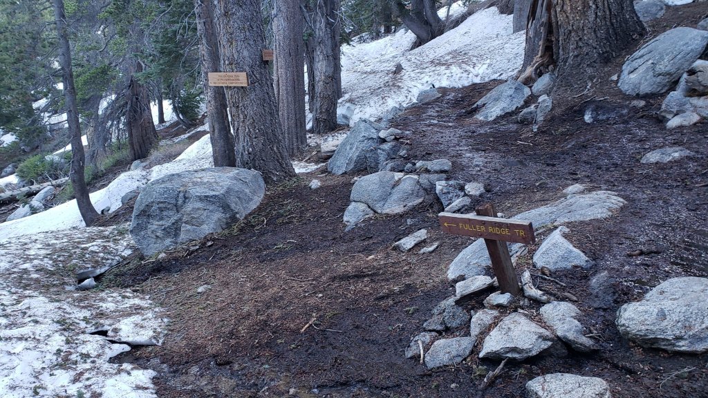
There is a boot track through an average of 30% moderate-to-deep snow cover on the PCT along Fuller Ridge (Miles 185.5-191). The track does now largely follow the PCT route. Miles 185.5-187.5 average about 40% snow cover, Miles 187.6-188.5 (mainly south-facing slope) is largely clear, Miles 188.5-190 has >80% snow cover, and Miles 190-191 are now largely clear. At this time continuing north on Fuller Ridge requires the comfort level to hike on icy snow on some angled terrain, and spikes are recommended. Some hikers may still prefer to use trail crampons.
A well established alternate from Idyllwild – avoiding Fuller Ridge – is to connect back to the PCT at about Mile 191 using Black Mountain Road. Black Mountain Road is now clear of snow
PCT hikers are reminded that overnight stays are not permitted at or near San Jacinto Peak by the State Park, including in the historic shelter. The shelter should be left available for use by emergency services at all times. Little Round Valley and Strawberry Junction are excellent overnight options for thru-hikers.

TRAIL CONDITIONS
Trails remain largely (or in places completely) snow-covered above about 8900 ft. This elevation will continue to rise steadily with melting into June. Trails below about 8000 ft are now generally clear of snow. Elevations between 8000-8900 ft vary considerably in snow cover depending on aspect, drifting, and tree cover, but typically average about 10-50% snow cover. Details of the PCT, its boot tracks, and alternates are given in the PCT section above.
Devil’s Slide Trail is clear of snow to Saddle Junction. Spikes are not required.
The Wellman Trail has largely continuous snow cover on its southern 0.4 mile north from Annie’s Junction, but snow cover is a very patchy 20% thereafter. The southern portion of the track (with continuous snow cover) does not always accurately follow the trail route, but the remainder of the track is now largely true to the trail route. Note there is considerable flowing water in the trail in several places for a few tenths of a mile around Wellman’s Cienega.
The Peak Trail route remains largely snow-covered. The initial traverse north from Wellman Divide has 35% rapidly thinning snow cover for about a mile to 9900 ft and the track largely follows the trail route, but thereafter snow cover is >90%. Around 9900-10,100 ft the boot track does not follow the trail route. Close to San Jacinto Peak the predominant boot track ascends directly up the East Ridge (not up the switchbacks of the upper Peak Trail) over continuous lumpy snow cover.
There is a well-traveled boot track through 70% snow cover largely following the trail route up from Round Valley to Wellman Divide. Extensive clear patches are opening up in and around Round Valley, though few are actually in the designated camping areas.
Deer Springs Trail is clear of snow to Strawberry Junction. The trail is then functionally clear of snow (only a few limited patches) for about 1.5 miles north of Strawberry Junction until just south of the Marion Mountain Trail junction. Thereafter the predominant boot track generally follows the true trail route through largely continuous snow until Fuller Ridge. Once the Deer Springs track leaves the PCT at the south end of Fuller Ridge, snow cover is about 20% for the first 0.6 mile (to about 9200 ft elevation). Thereafter snow cover averages 60% up to Little Round Valley, but with both extensive clear patches and some lengthy sections of continuous snow. There is now one predominant boot track that almost entirely follows the actual trail route. Snow cover remains >90% and heavily drifted through Little Round Valley. Above Little Round Valley there are multiple boot tracks through the largely continuous icy snow. Most ascend steeply and directly towards San Jacinto Peak, and while one of them does now approximate to the true trail route, it is not the predominant track. Cautious navigation is required on Deer Springs Trail, especially above Little Round Valley, and spikes are recommended, especially for descending.
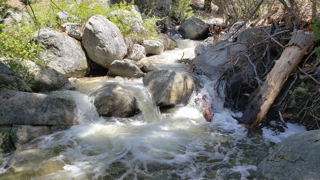
The Ernie Maxwell Trail is clear of snow. Crossing Chinquapin Creek just below Humber Park can be tricky as it is swollen with snowmelt.
South Ridge Trail is completely clear of snow to Tahquitz Peak. Fourteen recent treefall hazards on the trail were removed by the Trail Report on 16th May, and trail trimming is undertaken weekly. South Ridge Road remains closed to vehicle traffic, but is clear of snow and is tentatively scheduled to reopen in the first half of June.
Marion Mountain Trail is clear of snow for its lower 1.5 miles to 7500 ft. Snow then starts quite abruptly and from that elevation the softening snow cover averages 30% but with a mix of long clear sections and some lengthy snow patches. There is a great deal of water flowing in the trail in its uppermost mile, and there are many increasingly fragile snow bridges. The boot track is not always easy to follow in its uppermost section as it nears the PCT/Deer Springs Trail. Most hikers will prefer to use spikes, especially for descending parts of the upper half.
The Trail Report removed about 30 treefall hazards from Spitler Peak Trail on 25th May, bringing the total removed to just under 100 in the past two years. Half-a-dozen minor downed trees remain but none are significant obstructions. More worrisome are 5-6 washouts in the upper switchbacks which have significantly impacted the tread in places, necessitating significant trail recovery work (photos in prior Report).
Black Mountain Trail is functionally clear of snow. A few minor patches remain on the climber’s trail route from the top of Black Mountain Trail to near the fire lookout. Boulder Basin campground remains closed at this time.
Seven Pines Trail is clear of snow to 8200 ft elevation (about 2.5 miles up from the trailhead). The crossing of the very swollen North Fork of the San Jacinto River at 1.5 miles (just after the State Park boundary) is currently perilous and not recommended for most hikers. This will likely remain a dangerous crossing into July. Patchy snow cover steadily increases between 8200 ft and the junction with Deer Springs Trail/PCT (at about 8700 ft), but overall averages about 40%. Many of the drifts obscure key sections and switchbacks on the upper trail, and navigation will be challenging for those not extremely familiar with this trail. There is a very lightly traveled and poorly defined boot track through the snow patches. Of seven new treefall hazards down on the clear parts of the trail, six were removed by the Trail Report on 30th May, and a good start was made on clearing the trail of branches and other debris.
Dark Canyon Road – the access for Seven Pines Trail – is clear of snow, but remains closed to vehicles.
The section of Skyline Trail that falls within the State Park jurisdiction above 5800 ft elevation reopened on 19th May following a closure of nearly four months due to supposedly “hazardous” snow conditions. (For readers who are unclear, Skyline Trail forms the lower two-thirds of the “Cactus-to-Clouds” [C2C] route.) Skyline Trail is now functionally clear of snow.
SNOW DEPTHS
Measured on 1st June (east side) and 29th May (west side) 2023. The first number is the current average snow depth, followed in parentheses by the maximum depth recorded in winter 2022/23 where known. Note that broad averages are given; due to drifting in strong winds, and the differential effects of melting (and of rain on snow in some March storms), there is considerable inconsistency of depth. Altitudes and PCT Miles are approximate.
San Jacinto Peak (10810 ft): 26 inches, with clear patches developing, but drifts up to 4 feet deep remain in places (105 inches on 31st March)
Little Round Valley (9800 ft): 28 inches, with large clear patches but also many drifts up to 5 feet deep.
Wellman Divide (9700 ft): 12 inches, ranging from 0-30 inches (70-75 inches on both 3rd and 31st March)
Annie’s Junction/PCT Mile 180.8 (9070 ft): 18 inches, very patchy and heavily drifted here (80 inches on 3rd March)
Long Valley (8600 ft): 0 inches (60 inches on 3rd March)
Strawberry Junction/PCT Mile 183.2 (8100 ft): 0 inches
Saddle Junction/PCT Mile 179 (8070 ft): 0 inches (48-50 inches on 3rd March)
Devil’s Slide trailhead at Humber Park (6550 ft): 0 inches (46 inches on 3rd March)
Idyllwild (at 5550 ft): 0 inches (45 inches on 1st March)
PCT Mile 151 at crossing with Highway 74 (4800 ft): 0 inches (13 inches in first week of March)
While all time and labor is volunteered, the San Jacinto Trail Report uses small private donations to help cover modest operating costs. Every year has its unique challenges, and a remarkable 2023 is clearly no exception. Your contribution keeps the Report available to all, free from advertising or paywalls, and independent from agencies. If you have found this Report useful, please consider using this link to the Donate page. Zelle, Venmo, and PayPal are all options. Thank you so much for your support.


Great report! Thank you. Looks like camping at either Round Valley or Little Round Valley will be limited to snow camping. Is the pipe flowing at Round Valley?
LikeLike
There are snow-free areas in both valleys suitable for camping (just not necessarily in the normal camping locations). There is abundant water flowing in various places in both valleys. Safe hiking, Jon.
LikeLike