Temperatures well above seasonal on 12th-20th May greatly accelerated melting of snow, with many high country areas losing a further 12-18 inches of snow in the past week or so. Cooler weather for the remainder of the month, especially from 24th-29th, will slow snowmelt rates, and snow should be relatively firm underfoot, at least in the mornings.
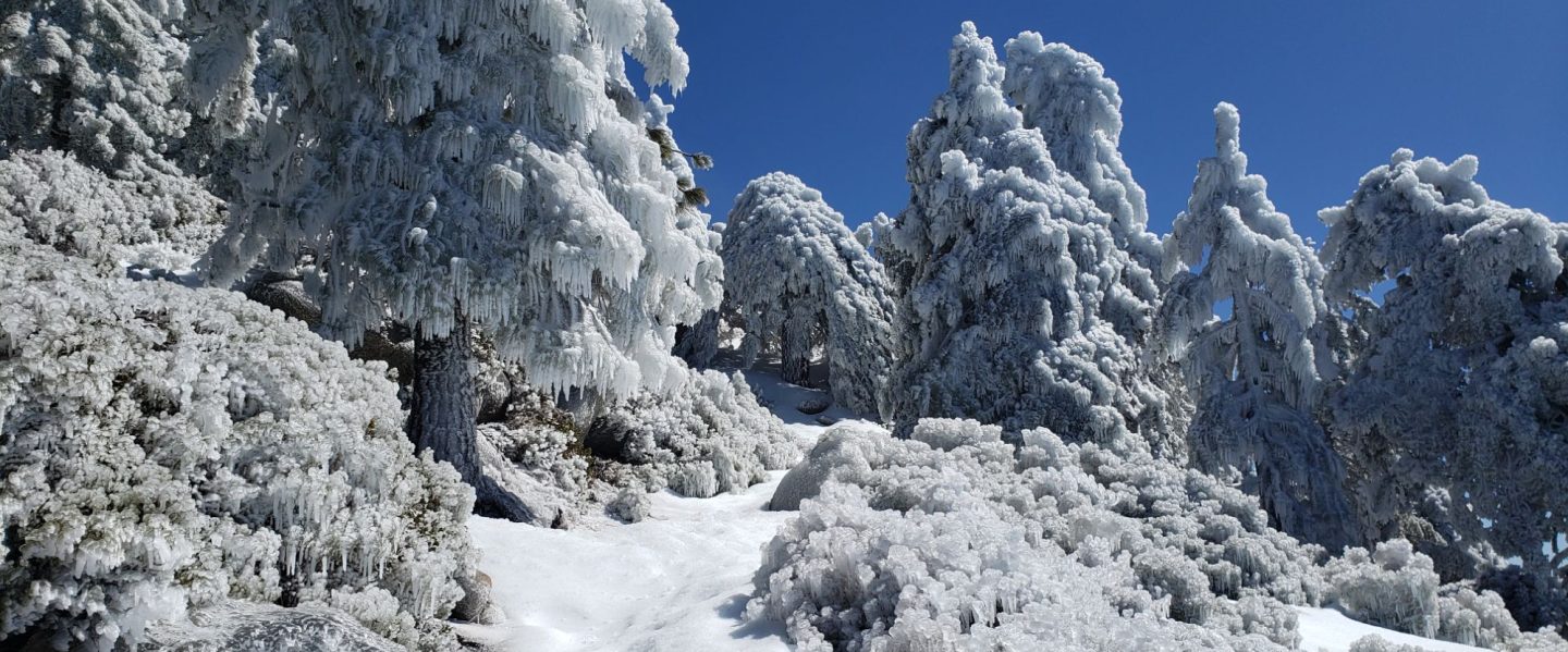
An exceptionally early monsoon weather pattern, more reminiscent of late summer than late May, has been another weather feature of the past week. A couple of wonderful monsoonal thunderstorms on Sunday 21st May combined for an impressive 0.72 inch of rain in Idyllwild, with 0.24 inch recorded at Saddle Junction (8100 ft), 0.11 inch at Wellman’s Cienega (9300 ft), and a light sprinkling on the highest peaks.
Hiking different routes to San Jacinto Peak multiple times per week facilitates assessment of snow conditions on the trail system around the high country including the highest sections of the PCT in the San Jacinto mountains (Miles 179-181 and 183-185.5). Our daily hikes in between mainly assess other parts of the PCT, side trails and alternates, including, for example, South Ridge Trail every week.
On Monday 22nd May (and again on Friday 26th) I didn’t require spikes for ascending San Jacinto Peak via the east side route using Devil’s Slide, Wellman, Peak and East Ridge trails. However spikes were useful for descending the western side via Deer Springs Trail, down to about 8700 ft. Cooler weather this week may harden the compacted snow tracks, improving the traction and hiking conditions. Overall spikes continue to be useful in the high country, and some hikers may prefer trail crampons, although neither are now essential hiking on the established boot tracks.
Trails above about 8900 ft remain largely obscured by light to moderate snow (lower in places). Trails as low as 8000 ft elevation can have shallow but increasingly patchy snow cover, especially on north-facing slopes. The reliable boot tracks of April and early May have become increasingly scrappy with the widespread but patchy melting of recent weeks. Cautious navigation remains important everywhere.
Details of snow depths measured at various locations on the trail system are given at the foot of this posting. Note that snow depth itself is rarely indicative of the difficulty (or otherwise) of hiking a particular track or trail. For example a firm, well-compacted track across snow several feet deep is often much easier hiking than a poorly defined track across just a few inches depth of angled ice.
Traction decisions have generally become much easier again following the minor snowstorm in early May. The optimum traction device at any given time and place depends on a complex interaction of factors including time of day, sun exposure of the trail, air temperature, quality of footwear tread, and extent to which a track has been traveled and compacted. The willingness of the hiker to posthole in soft afternoon snow (which is rarely easy or fun) also influences choice of traction.
Spikes remain useful for the foreseeable future above about 9000 ft (lower in places) but they may no longer be required depending upon the specifics of the route, the hiker’s comfort level hiking on icy snow, plus the quality of footwear being used. This elevation will continue to move steadily upwards with melting of snow over the next few weeks, but spikes will remain useful throughout June at least in parts of the high country. Spikes tend to be especially helpful for descending even when they are not required for ascending.
Crampons – with hiking poles and/or an ice axe, depending on terrain – are becoming less valuable, but remain potentially useful everywhere above about 9000 ft. Some hikers will find them useful anywhere off-trail in the high country on colder mornings, and on-trail on certain moderate and higher angle slopes, such as the Peak Trail above Wellman Divide, Deer Springs Trail above Little Round Valley, and especially on the short section of South Ridge Trail across the north face of Tahquitz Peak.
Snowshoes remain useful above about 9000 ft for off-trail travel over the next few weeks, for example to reach the >10,000 ft peaks that are not connected by well-traveled tracks. Snow away from the compacted tracks generally softens rapidly by mid morning once direct sun hits slopes and temperatures rise.
In addition to snow and navigation issues, hikers should anticipate encountering many new treefall hazards on all trails, along with considerable amounts of debris, branches, cones, etc. While some of these issues are a consequence of the recent intense winter, most trails in the San Jacinto mountains have been inadequately maintained for years largely due to agency dysfunction, plus some effects of wildfires, the coronavirus pandemic, and climate change. In addition there can be a great deal of water in (and under) the trails, and this has also created some tricky crossings. Be very cautious of snow bridges across water.
Hikers should be prepared for temperatures near freezing in the high country, and below freezing when considering wind chill effects (see below for my recent weather observations from San Jacinto Peak).
Forest Service roads currently closed to vehicular traffic include Dark Canyon Road (4S02), South Ridge Road (5S11), and Santa Rosa Road (7S02), plus all their various side roads. The USFS gate at Humber Park reopened on Wednesday 19th April. The State Park Stone Creek campground reopened in early May, but Forest Service campgrounds remain closed at this time. Black Mountain Road (4S01) has effectively reopened. The gate 1.7 miles from the highway was vandalized in mid May and the Forest Service have decided to leave it open for now. The road is in its poorest condition for at least a decade and 4WD and/or high clearance are recommended.
WEATHER
Daytime temperatures are forecast to be below seasonal for May from 24th-31st, while overnight lows will be cooler than last week but about seasonal for the month. Air temperatures in the high country will remain just above freezing, but with windchills at or below freezing around the highest peaks. Temperatures will steadily warm to near seasonal in the first week of June. With the monsoonal easterly air flow now breaking down, there is no significant new precipitation in the forecasts.
At San Jacinto Peak (10,810ft/3295m) on Monday 22nd May 2023 at 0825 the air temperature was 43.9°F (7°C), with a windchill temperature of 36.7°F (3°C), 72% relative humidity, and a light SSW breeze sustained at 2 mph gusting to 6.8 mph.
At the Peak on Friday 19th May 2023 at 0805 the air temperature was 46.3°F (8°C), with a “windchill” temperature of 44.8°F (7°C), 37% relative humidity, and a near-calm SW breeze sustained at 0 mph gusting to 2.7 mph.
At the Peak on Monday 15th May 2023 at 0750 the air temperature was 41.6°F (5°C), with a windchill temperature of 30.7°F (-1°C), 39% relative humidity, and a fresh ESE wind sustained at 11 mph gusting to 18.8 mph.
PACIFIC CREST TRAIL INFORMATION
The PCT is now largely clear of snow through the San Jacinto mountains. However two significant sections remain extensively snow-covered.
The trail is clear from Miles 151 (Highway 74) to about Mile 175. Treefall hazards are a problem on this section but none are insurmountable. I counted at least 94 between Miles 169-175 on 1st May. Apache Peak (Mile 169.5) has been clear of snow for several weeks.
Snow cover is about 70% from Miles 175 (Red Tahquitz) to 177.7 (Chinquapin Flat), but with a well traveled track through the extended snow patches and with very limited consequential terrain. Many hikers will find that spikes can be useful on this section. Note that the posthole track on Miles 175-178 does not accurately follow the trail route in places.
PCT hikers should not attempt to use South Ridge Trail from the PCT at Chinquapin Flat (roughly Mile 177.7) to Idyllwild via Tahquitz Peak, even though this looks temptingly simple on apps and maps. There are no reliable steps to follow through a section of steeply angled (and notoriously treacherous) ice. Crampons, always with an ice axe, and expert knowledge of how to use this equipment on high angle terrain, are required. Even in low snow years these slopes always take many weeks longer to clear of ice than adjacent areas, and they are not expected to fully clear until the first week of June this year.
Snow cover is increasingly patchy and averages <50% between Miles 177.7 to Saddle Junction (about Mile 179). The south-facing slope of Miles 179-180 is clear of snow, but from Mile 180 (elevation 8900 ft) to about Mile 181 just past Annie’s Junction snow cover is >95% and the track can be hard to follow in places. Miles 181-184 are functionally clear of snow, and snow cover then becomes largely continuous from Mile 184.5. Spikes can be useful on the snowy parts of this section, but are not required at this time for hikers experienced with snow travel.
There is a boot track through an average of 60% moderate-to-deep snow cover on the PCT along Fuller Ridge (Miles 185.5-191). My video report from 10th May (available here) remains largely relevant. The track does not accurately follow the PCT route in some places and passes through some challenging terrain, especially in Miles 185.5-187. At this time continuing north on Fuller Ridge requires the skills and comfort level to hike on angled terrain with some moderate exposure, and spikes are recommended. Many hikers I have seen and talked to are carrying an ice axe to use with their spikes. Some hikers may still prefer to use trail crampons. Judging by what I see and hear firsthand on the mountain, most hikers are now passing through Fuller Ridge, but a significant percentage continue to prefer using the Black Mountain Road alternate at this time.
There is a potentially dangerous myth circulating on PCT social media that going up and over San Jacinto Peak somehow avoids Fuller Ridge. Whether you remain on the PCT northbound (going around at lower elevation via Strawberry Junction) or leave the PCT at Annie’s Junction (Mile 180.8) to go up to San Jacinto Peak and then down the west side to reconnect to the PCT at about Mile 185.5, you still have to hike Fuller Ridge (which is Miles 185.5-190.5). It is possible to do the former route more safely by leaving the PCT at Strawberry Junction (approx. Mile 183) and descending Deer Springs Trail, which is completely clear of snow below Strawberry Junction, back into Idyllwild.
A well established alternate from Idyllwild – avoiding Fuller Ridge – is to connect back to the PCT at about Mile 191 using Black Mountain Road. Black Mountain Road is clear of snow for the lower five miles, and then is functionally clear (increasingly patchy 10% snow cover) for the upper three miles to the PCT. Mile 191 northward to Interstate 10 is clear of snow.
PCT hikers are reminded that overnight stays are not permitted at or near San Jacinto Peak by the State Park, including in the historic shelter. The shelter should be left available for use by emergency services at all times. Little Round Valley and Strawberry Junction are excellent overnight options for thru-hikers.

TRAIL CONDITIONS
Trails remain largely or completely snow-covered above about 8900 ft. This elevation will continue to rise steadily with melting into June. Trails below about 7700 ft are now clear of snow. Elevations between 7700-8900 ft vary considerably in snow cover depending on aspect, drifting, and tree cover, but typically average about 10-50% snow cover. Details of the PCT, its boot tracks, and alternates are given in the PCT section above.
The section of Skyline Trail that falls within the State Park jurisdiction above 5800 ft elevation reopened on 19th May following a closure of nearly four months due to supposedly “hazardous” snow conditions. (For readers who are unclear, Skyline Trail forms the lower two-thirds of the “Cactus-to-Clouds” [C2C] route.) Skyline Trail is now functionally clear of snow.
Devil’s Slide Trail is clear of snow to Saddle Junction. Spikes are not required.
The Wellman Trail has continuous snow cover on its southern 0.4 mile, but snow cover is a very patchy 40% otherwise. The southern portion of the track (with continuous snow cover) does not accurately follow the trail route, but the remainder of the track is now largely true to the trail route. Note there is considerable flowing water in the trail in several places in the area of Wellman’s Cienega.
The Peak Trail route remains largely snow-covered. The initial traverse north from Wellman Divide has about 90% rapidly thinning snow cover for about a mile to 9900 ft and the track largely follows the trail route, but thereafter snow cover is continuous. Multiple meandering boot tracks are becoming increasingly scrappy above 10,000 ft, especially on the main traverse up to near Miller Peak, they only vaguely approximate to the trail route, and the going is consequently slow. Close to San Jacinto Peak the boot track ascends directly up the East Ridge (not the switchbacks of the upper Peak Trail).
There is a well-traveled boot track through largely continuous snow up from Round Valley to Wellman Divide. Extensive clear patches are opening up in and around Round Valley, though few are actually in the designated camping areas.
Deer Springs Trail is clear of snow to Strawberry Junction. The trail is then functionally clear of snow (only a few limited patches) for about 1.3 miles north of Strawberry Junction to about 8600 ft just south of the Marion Mountain Trail junction. Thereafter the predominant posthole track largely follows the true trail route through almost continuous snow until Fuller Ridge. Once the Deer Springs track leaves the PCT at the south end of Fuller Ridge, there is rarely one predominant boot track, and there are often multiple lightly-traveled tracks generally taking direct routes up the various snow slopes and only periodically approximating to the trail route. Snow cover is about 90% up to Little Round Valley, and functionally continuous thereafter. Above Little Round Valley there are multiple poorly-defined boot tracks which ascend steeply and directly towards San Jacinto Peak, none of them approximating to the true trail route. Cautious navigation is required on Deer Springs Trail, especially above the Fuller Ridge Trail junction, and spikes are recommended, especially for descending.
The Ernie Maxwell Trail is clear of snow. Crossing Chinquapin Creek just below Humber Park can be tricky as it is swollen with snowmelt.
The 0.4 mile section of South Ridge Trail between the PCT at Chinquapin Flat and Tahquitz Peak has no steps to follow through a short but steeply angled section of icy snow. These icy slopes are melting fast, but remain treacherous. Currently crampons, always with an ice axe, and thorough knowledge of how to use this equipment on high angle terrain, remain required. At current melt rates the trail is expected to be passable without additional traction in the first week of June.
South Ridge Trail is completely clear of snow to Tahquitz Peak on the southern approach from South Ridge Road. Fourteen recent treefall hazards on the trail were removed by the Trail Report on 16th May, and trail trimming is undertaken weekly. South Ridge Road remains closed to vehicle traffic, but is clear of snow and is tentatively scheduled to reopen in the first half of June.
Marion Mountain Trail is clear of snow for its lower 1.5 miles to 7500 ft. Snow then starts quite abruptly and from that elevation the softening snow cover averages 30% but with a mix of long clear sections and some lengthy snow patches. There is a great deal of water flowing in the trail in its uppermost mile, and there are many increasingly fragile snow bridges. The boot track is not always easy to follow in its uppermost section as it nears the PCT/Deer Springs Trail. Most hikers will prefer to use spikes, especially for descending parts of the upper half.
The Trail Report removed about 30 treefall hazards from Spitler Peak Trail on 25th May, bringing the total removed to just under 100 in the past two years. Half-a-dozen minor downed trees remain but none are significant obstructions. More worrisome are 5-6 washouts in the upper switchbacks which have significantly impacted the tread in places, necessitating significant trail recovery work (photos in prior Report).
Black Mountain Trail is completely clear of snow for 3.5 miles. The final 0.3 mile in the uppermost switchbacks has about 20% snow cover in patches. There is a lightly-traveled posthole track through those snow patches. From the top of the trail to the fire lookout, snow cover remains about 40%, but is soft and thinning rapidly. Black Mountain Road is functionally clear of snow but remains closed to vehicles at the gate 1.7 miles up from Highway 243.
Dark Canyon Road – the access for Seven Pines Trail – is clear of snow, but remains closed to vehicles.
SNOW DEPTHS
Measured on 22nd May 2023. The first number is the current average snow depth, followed in parentheses by the maximum depth recorded in winter 2022/23 where known. Note that broad averages are given; due to drifting in strong winds, and the differential effects of melting (and of rain on snow in some March storms), there is considerable inconsistency of depth. Altitudes and PCT Miles are approximate.
San Jacinto Peak (10810 ft): 30-36 inches, with some clear patches on south facing slopes, but drifts 5-6 feet deep remain in places (105 inches on 31st March)
Little Round Valley (9800 ft): 35 inches, with increasingly large clear patches but also many drifts 4-5 feet deep.
Wellman Divide (9700 ft): 20 inches, ranging from 0-50 inches (70-75 inches on both 3rd and 31st March)
Annie’s Junction/PCT Mile 180.8 (9070 ft): 30-35 inches (80 inches on 3rd March)
Long Valley (8600 ft): 0 inches (60 inches on 3rd March)
Strawberry Junction/PCT Mile 183.2 (8100 ft): 0 inches
Saddle Junction/PCT Mile 179 (8070 ft): 0-6 inches, largely clear but a few snow drifts 12-15 inches deep (48-50 inches on 3rd March)
Devil’s Slide trailhead at Humber Park (6550 ft): 0 inches (46 inches on 3rd March)
Idyllwild (at 5550 ft): 0 inches (45 inches on 1st March)
PCT Mile 151 at crossing with Highway 74 (4800 ft): 0 inches (13 inches in first week of March)


While all time and labor is volunteered, the San Jacinto Trail Report uses small private donations to help cover modest operating costs. Every year has its unique challenges, and a remarkable 2023 is clearly no exception. Your contribution keeps the Report available to all, free from advertising or paywalls, and independent from agencies. If you have found this Report useful, please consider using this link to the Donate page. Zelle, Venmo, and PayPal are all options. Thank you so much for your support.


thanks Jon… fyi 4S01 was opened mid last week, i have a cabin in Pinewood and went up it to yellow posts ( about 7600 ft elev) and saw gate opened and several 4x4s on it plus lots ts of PCT hikers… FS had told me not until june 8, but it is indeed now open. btw, large patches of sniw start around 7599 ft , on eastern and northern facing slopes … thanks! morgan
Sent from Yahoo Mail for iPhone
LikeLike
Thanks Morgan, I had already updated the Trail Report with that info. Sadly the gate on Black Mountain Road was vandalized, apparently forcing Forest Service to open the gate earlier than planned.
LikeLike