UPDATE Thursday 30th March 2023 at 1130: the 24th storm of this remarkable winter produced nearly three inches of snow in Idyllwild overnight, following a day of steady rain almost all day yesterday (totaling 0.7 inch at 5550 ft). Light snow in the high country yesterday and overnight totaled about 5 inches in Long Valley (8600 ft). Overnight it snowed down to 4000 ft, and I measured 2 inches at PCT Mile 151 early this morning, as described in a short video report I recorded there (available here on YouTube). It has periodically cleared in the high country above about 8000 ft elevation this morning, and also in Garner Valley, but it continues to snow steadily at mid elevations (e.g., in Idyllwild), with another 1-2 inches added since 0700.
——————————–
This is an outline of current snow and trail conditions, details of the situation after the last major storm were summarized in the previous Report (available here). The next storm, forecast to be relatively minor, is on its way on Wednesday 29th and Thursday 30th March. With a freeze level at around 4000-4500 ft elevation, a few inches of snow are expected at the mid elevations, including almost all of the PCT in the San Jacinto mountains. About 6-8 inches of snow are currently forecast for the high country.
The State Park wilderness closed on 1st March (see State Park website). At this time there is no tentative date for reopening. This closure includes PCT Miles 183-189. An additional closure applies to Skyline Trail (part of the C2C route) as discussed below under Trail Conditions.
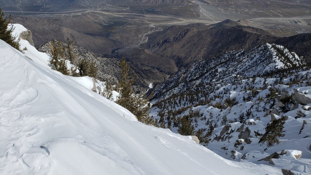
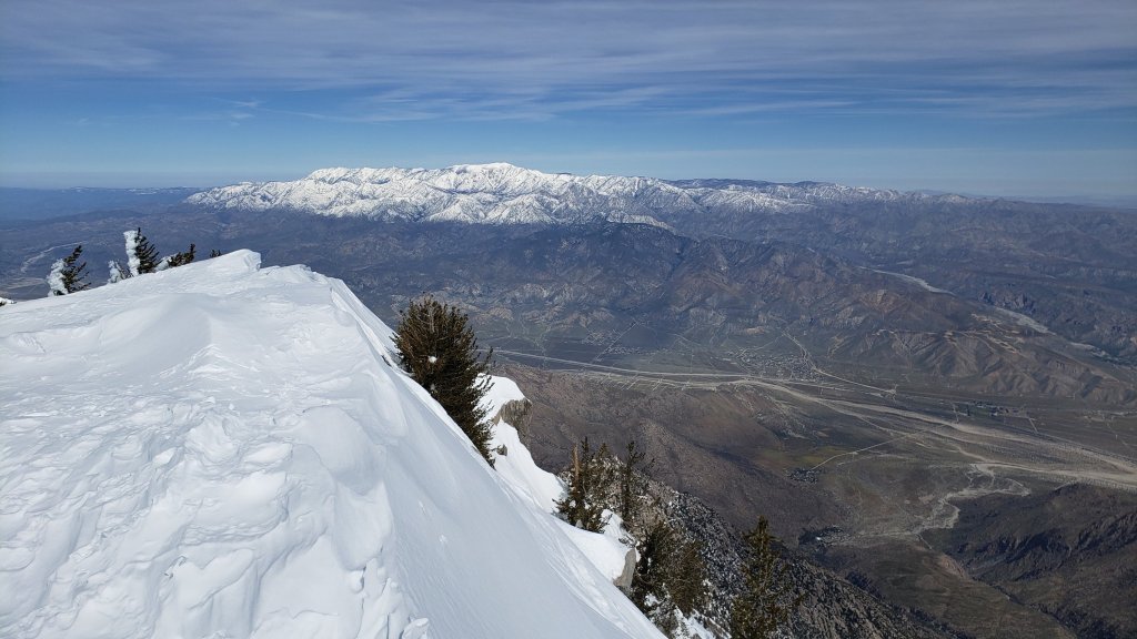
Currently there is no avalanche risk on the high country slopes that are crossed by the established trail network, based on my multiple surveys since the latest snowfall. There remains a moderate avalanche risk for the Snow Creek drainage on the north face of San Jacinto Peak, most likely immediately following the next snowfall. The biggest avalanche of the season so far occurred at around 7000-7500 ft in the Snow Creek drainage on 22nd-23rd March, immediately after last week’s heavy snowfall, and a substantial debris field is readily visible even from San Jacinto Peak in the 5000-7000 ft elevation range (photo below).
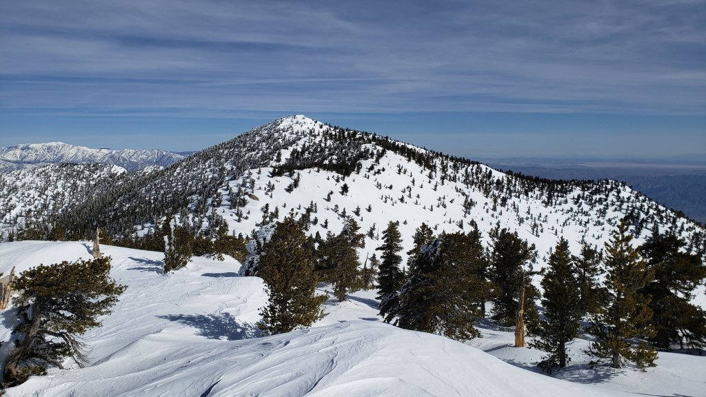
My survey hike on Monday 27th – in my capacity as a volunteer wilderness ranger for the State Park – initially took me up Devil’s Slide Trail to Wellman’s Cienega. A firm compacted track on the former was ideal for spikes, but I switched to snowshoes just above Saddle Junction, and kept them on for the remainder of the hike, including the entire descent of Devil’s Slide in early afternoon. From the cienega, I went directly upslope, gaining the ridge on the south flank of Jean Peak. I followed the high country ridge up over Jean to San Jacinto Peak, before breaking trail on a more conventional descending route via (roughly) the East Ridge, Peak and Wellman trails back to the PCT. Despite its great depth, the high country snow was firm and I was sinking in only a few inches at most. I was surprised to find much of my snowshoe track from Wednesday 22nd remained just visible.
Currently trails above about 6500 ft are obscured by moderate to deep snow. Trails down to 5000 ft elevation currently have shallow and increasingly patchy snow cover. With the State Park closure in place, there are very few tracks anywhere above 8000 ft. Very cautious navigation is essential everywhere.
Details of snow depths measured at various locations on the trail system are given at the foot of this posting. Note that snow depth itself is rarely indicative of the difficulty (or otherwise) of hiking a particular track or trail. For example a firm, well-compacted snowshoe or crampon track across snow several feet deep may be much easier hiking than an angled icy section just inches deep.
Conditions are currently excellent for snowshoes everywhere above about 8000 ft (potentially lower in places for the next week or so). Tracks in the high country can be firm if the early morning is cold (crampons or even spikes best) but then soften rapidly once sun hits slopes and temperatures rise, at which point snowshoes are preferable.
To give an idea of the current traction challenge, I am generally hiking with all three of snowshoes, crampons, and spikes every time I go into the high country at present, changing between them as conditions warrant.
Crampons – with hiking poles and/or an ice axe, depending on terrain – are becoming increasingly useful everywhere especially above about 7000 ft, as cold temperatures on some days, plus freeze/thaw cycles, lead to hardening of the snow surfaces. They will likely become invaluable over the next week or so on certain moderate and higher angle slopes, at a minimum on the Peak Trail above Wellman Divide, the Wellman Trail, Deer Springs Trail above Little Round Valley, and uppermost South Ridge Trail, and on both flanks but critically on the north face of Tahquitz Peak.
Increasingly as snow conditions change spikes are strongly recommended for the foreseeable future everywhere above about 5500 ft. They can currently be valuable even for walking around Idyllwild early on cold mornings! This elevation will slowly move upwards with steady melting over the next few days and weeks, but will remain relatively low well into April.
Hikers should be prepared for temperatures below freezing in the high country, and well below freezing when considering wind chill effects (see below for my recent weather observations from San Jacinto Peak).
The USFS gate at Humber Park is closed. Even when the gate is closed there are nine legal parking spaces below the locked gate (which still require an Adventure Pass or equivalent to be displayed). If there are “Road Closed” signs across Fern Valley Road near its junction with Forest Drive – currently the case – then those nine spaces are also unavailable for legal parking.
Forest Service roads currently closed to vehicular traffic by a revised closure order include Black Mountain Road (4S01), Dark Canyon Road (4S02), South Ridge Road (5S11), May Valley Road (5S21), and Santa Rosa Road (7S02), plus their various side roads.
Palm Springs Aerial Tramway will be closed for maintenance on Monday 27th and Tuesday 28th March.
WEATHER
Conditions continue unsettled for the remainder of March. Two brief warm spells, on Tuesday 28th, and then again on 1st-2nd April, bookend the next minor storm system on 29th-30th. A mix of rain and 4-6 inches of snow are forecast for mid elevations (e.g., Idyllwild) with about 6-8 inches of snow for the high country. The system will be relatively cold, with snow expected to dust as low as 4000 ft, particularly on the night of Wednesday 29th. Winds – and therefore windchill temperatures – will be severe on the nights of 28th and 29th.
While somewhat more stable, sunnier weather with temperatures slightly warmer than the first three months of the year may start around 1st April, cold, cloudy, windy days nevertheless remain forecast for 3rd and 8th April at least, especially in the high country.
At San Jacinto Peak (10,810ft/3295m) on Monday 27th March 2023 at 1045 the air temperature was 25.3°F (-4°C), with a windchill temperature of 12.6°F (-11°C), 19% relative humidity, and a light WNW wind sustained at 7 mph gusting to 11.3 mph.
At the Peak on Monday 20th March 2023 at 1435 the air temperature was 20.8°F (-6°C), with a windchill temperature of 0.5°F (-18°C), 44% relative humidity, and a stiff due West wind sustained at 17 mph gusting to 28.0 mph, in complex, multi-layer cloud.
SOME THOUGHTS FOR PCT HIKERS
Between the State Park closure and the storms continuing in March, completing the San Jacinto mountains is currently a major challenge even for experienced hikers. That said, melting will happen fast once it starts in earnest – it is still Southern California after all – and because prior melting was accelerated by some storms bringing intense warm rain on top of the snow, especially below about 8000 ft which includes most of the PCT in these mountains.
Conditions in the southernmost sections will generally improve starting in the first week of April (judging by the forecasts), and most or even all areas will become readily passable with – crucially – suitable skills and equipment, patience, and a thorough knowledge of all the possible alternates if needed.
Recently I have mentioned the challenges of hard, icy snow underfoot and the value of using spikes (and/or crampons) especially for descending and traversing. While fresh snow (and softening, melting, snow) may be optimum for snowshoeing for the next several weeks, snow at all elevations will generally become increasingly firm and icy following multiple freeze-thaw cycles, and compaction by increasing hiker traffic in places (especially once high country trails reopen). I cannot overemphasize the importance of having both appropriate equipment and the right skill set for the terrain. The latter includes interpreting the snow/ice conditions, understanding your physical and mental abilities, and conservative decision making. These concerns will steadily increase over the next few weeks with temperatures fluctuating either side of freezing, seasonally stronger insolation, and highly variable snowmelt.
The remarkable winter has created some challenges in addition to the snow. There can be a great deal of water in the trails, and this has also created a few tricky crossings. Be cautious of snow bridges across water. Forested trails are covered with downed branches and debris, plus many new treefall hazards, some of which are only becoming apparent as the snow recedes. Trail maintenance by agencies was already years behind schedule due to the coronavirus pandemic, among other reasons, and this winter has greatly exacerbated the situation. Again, patience and caution will be essential this season more than most.
The PCT from Mile 151 (Highway 74 crossing) to Mile 166 (Fobes Trail) is clearing of snow steadily [checked 23rd and 24th March 2023], see photo in previous Report. Fobes Ranch Road and Fobes Trail [checked 24th] are also either clear or clearing of snow (more continuous snow a few inches deep remains on upper Fobes Trail).
Proceeding north from about Mile 166 currently requires considerable snow hiking experience. At this time I recommend carrying snowshoes, crampons, and ice axe, plus you will need the necessary snow hiking experience to use that equipment safely in moderate angle terrain, plus patience, stamina, and route-finding skills.
A well established alternate is to connect back to the PCT at about Mile 191 using Black Mountain Road. Black Mountain Road currently has continuous moderate snow cover but there are tracks to follow through the snow, and melting of the lower section will proceed steadily over the next week or so. Soon the conditions will be silimar to my survey on 17th March, when the Road had 50% snow cover on the lower two miles, 90% cover for the next three miles averaging 2-6 inches deep, then 100% cover for the upper three miles, at 6-18 inches deep. Early on cold mornings the snow is hard and icy making it easy to hike, but snow is soft and postholing is poor by late morning. At last check, no vehicle had driven up from Highway 243 since the last snows.

TRAIL CONDITIONS
Trails above about 5000 ft remain largely snow-covered (wholly snow-covered above about 6000 ft). This will change steadily with further melting over the next few days and weeks.
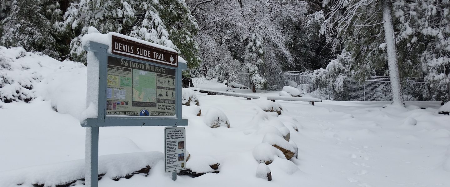
Devil’s Slide Trail has a good snowshoe track to follow up to Saddle Junction. It is firm in cold early mornings (ideal for spikes all the way to Saddle) but it can be very soft otherwise, as early as late morning (snowshoes required, or expect deep and wet postholing). Beware of water flowing in the trail, often obscured under thinning snow, and some associated tricky stream crossings. The track does not follow the established trail route in the uppermost switchbacks close to Saddle Junction, and careful navigation is required.
My snowshoe track from multiple ascents/descents continues on to San Jacinto Peak, via a route roughly approximating to the PCT, Wellman, Peak, and East Ridge trails, climbing more steeply in places than the established trails, and generally contouring through the snow as needed to minimize unnecessary elevation loss. Fresh snow expected on 29th-30th March will likely eliminate parts of the track.
As of Monday 27th, there were no tracks on the PCT south of Saddle Junction (Mile 179) towards Chinquapin Flat (Mile 177.5). There were snowshoe tracks around the Skunk Cabbage Meadow triangle.
The 0.4 mile section of South Ridge Trail between the PCT at Chinquapin Flat and Tahquitz Peak has no steps to follow through the steeply angled ice with overlying deep snow. These icy slopes are notoriously treacherous. Currently crampons, always with an ice axe, and thorough knowledge of how to use this equipment on high angle terrain, are essential. Snowshoes are not advisable due to the angle of the icy snow.
A reliable snowshoe track was put in on lower Deer Springs Trail to Strawberry Junction on Friday 24th March. There is no evidence of any tracks from Little Round Valley up to the San Jacinto Peak area at this time.
Spitler Peak Trail [surveyed 26th March] is clear of snow in its lower half (first 2.4 miles). The upper half of the trail has continuous light snow cover. The initial part of this snowy section has an excellent snowshoe track to follow, but this ends about 3.8 miles from the highway, about one mile below the PCT junction.
In addition to the wider closure mentioned above, effective 26th January 2023 the State Park closed the section of Skyline Trail that falls within its jurisdiction, above 5800 ft elevation, “until further notice due to dangerous weather conditions”. (For readers who are unclear, Skyline Trail forms the lower two-thirds of the “Cactus-to-Clouds” [C2C] route.) The State Park boundary is not marked but is near the site of the old Florian’s Cache, below Flat Rock. The open section of trail below 5800 ft received some light snow cover down to about 4500 ft over the past week, but this has already melted.
SNOW DEPTHS
Measured on Monday 27th March unless otherwise stated. The first number is the current snow depth, followed in parentheses by the maximum depth at that location in winter 2022/23. Note that averages are given; due to strong winds accompanying all storms, and the differential effects of rain on snow in some earlier storms, there is considerable inconsistency of depth. Altitudes and PCT Miles are approximate.
San Jacinto Peak (10810 ft): 95 inches (98-105 inches on 22nd March)
Wellman Divide (9700 ft): 65 inches (70-75 inches on 3rd March)
Annie’s Junction/PCT Mile 180.8 (9070 ft): 70 inches (80 inches on 3rd March)
Long Valley (8600 ft): 45 inches (c.60 inches on 3rd March)
Saddle Junction/PCT Mile 179 (8070 ft): 38 inches (48-50 inches on 3rd March)
Devil’s Slide trailhead at Humber Park (6550 ft): 10-15 inches (46 inches on 3rd March)
Idyllwild (at 5550 ft): 3-6 inches (45 inches on 1st March)
PCT Mile 151 at crossing with Highway 74 (4800 ft): 0 inch, measured 23rd March (13 inches in first week of March)
While all time and labor is volunteered, the San Jacinto Trail Report uses small private donations to help cover modest operating costs. Every year seems to have its unique challenges, and clearly 2023 will be no exception. Your contribution keeps the Report available to all, free from advertising or paywalls, and independent from agencies. If you have found this Report useful, please consider using this link to the Donate page. Zelle, Venmo, and PayPal are all options. Thank you so much for your support.