[UPDATE Friday 26th February: Forest Service reopened gates at Humber Park, South Ridge Road (5S11), and May Valley Road (5S21) today.]
[For information specific to the Pacific Crest Trail, please see the dedicated PCT report, best used in conjunction with this most recent general update.]
We have continued to hike daily on the mountain this year, with many recent hikes focused on subsections of the PCT, including the Spitler area on 21st. I had an easy ascent of San Jacinto Peak on 22nd, on firm icy snow up the east side trails via Devil’s Slide (no spikes required on the ascent, but used on much of the descent). Barring a significant change to the forecast, the very minor storm that passed through on Friday 12th February will be our only precipitation of what is normally one of the wettest months of the year.
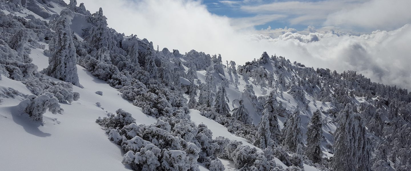
Melting has been steady at all elevations with several recent days of temperatures well above average. Sun-exposed slopes in particular are starting to clear, with conditions more reminiscent of a “normal” April or May. At San Jacinto Peak on 22nd, I measured an average of about 19 inches, a loss of nearly one foot in a week. Spikes are recommended on all well-traveled trails above about 7500ft (lower in places discussed below), especially in the morning and for descending, as established trails are now compacted by hiker traffic and freeze-thaw cycles. Snowshoes are recommended only for some off-trail travel above about 9000ft, mainly afternoons when snow is softer.
Hikers should be prepared for temperatures at or below freezing in the high country, and potentially well below freezing when considering wind chill effects (see below for temperatures recorded recently at San Jacinto Peak).
The Palm Springs Aerial Tramway reopened on 18th February, with reduced days, hours, and capacity. See their website for details.
The Idyllwild ranger station of Mount San Jacinto State Park reopened on 6th February, and the adjacent campground reopened on 12th February. Wilderness camping in the State Park has also reopened, see the State Park website for further information.
WEATHER Temperatures well above seasonal will largely continue this week, before dropping to around (or even slightly below) seasonal after Saturday 27th, and continuing into March. Minor storm systems are possible around 2nd-3rd March, perhaps including a light snowfall in the high country.
February has historically been one of the two wettest months (along with January) in the San Jacinto mountains. With only one very minor storm on 12th this year, February 2021 is destined to be even drier in the high country than February 2020, which was previously the driest February recorded at higher elevations since consistent records began (in the 1940s in Idyllwild, in the 1960s in the high country).
At San Jacinto Peak (10,810ft/3295m) on Monday 22nd February 2021 at 0910 the air temperature was 39.3°F (4°C), with a windchill temperature of 32.2°F (0°C), 33% relative humidity, and a light SSE breeze sustained at 4 mph gusting to 6.2 mph.
At the Peak on Monday 15th February 2021 at 0855 the air temperature was 30.1°F (-1°C), with a windchill temperature of 12.9°F (-10°C), 69% relative humidity, and a gusty NNW wind sustained at 14 mph gusting to 26.1 mph.
TRAIL CONDITIONS
All trails above about 8600ft remain extensively snow-covered. Areas below 7500ft are patchy or rapidly clearing of snow, with the exception of north-facing slopes (down to about 6500ft). Areas between those elevations are largely snow-covered, but with clearing on sun-exposed slopes.
Tahquitz Peak trail from Chinquapin Flat/PCT Mile 178 has challenging steps to follow through the angled icy snow. These icy slopes are notoriously treacherous. Currently spikes (used in conjunction with at least hiking poles, or preferably an ice axe) are essential. Do not attempt to use snowshoes due to the angle of the icy snow.
Devil’s Slide Trail is largely clear of snow to 7700′ with a few extended icy snow patches remaining. Snow is almost continuous above that elevation to Saddle Junction. The trail is hard and icy and spikes are useful.
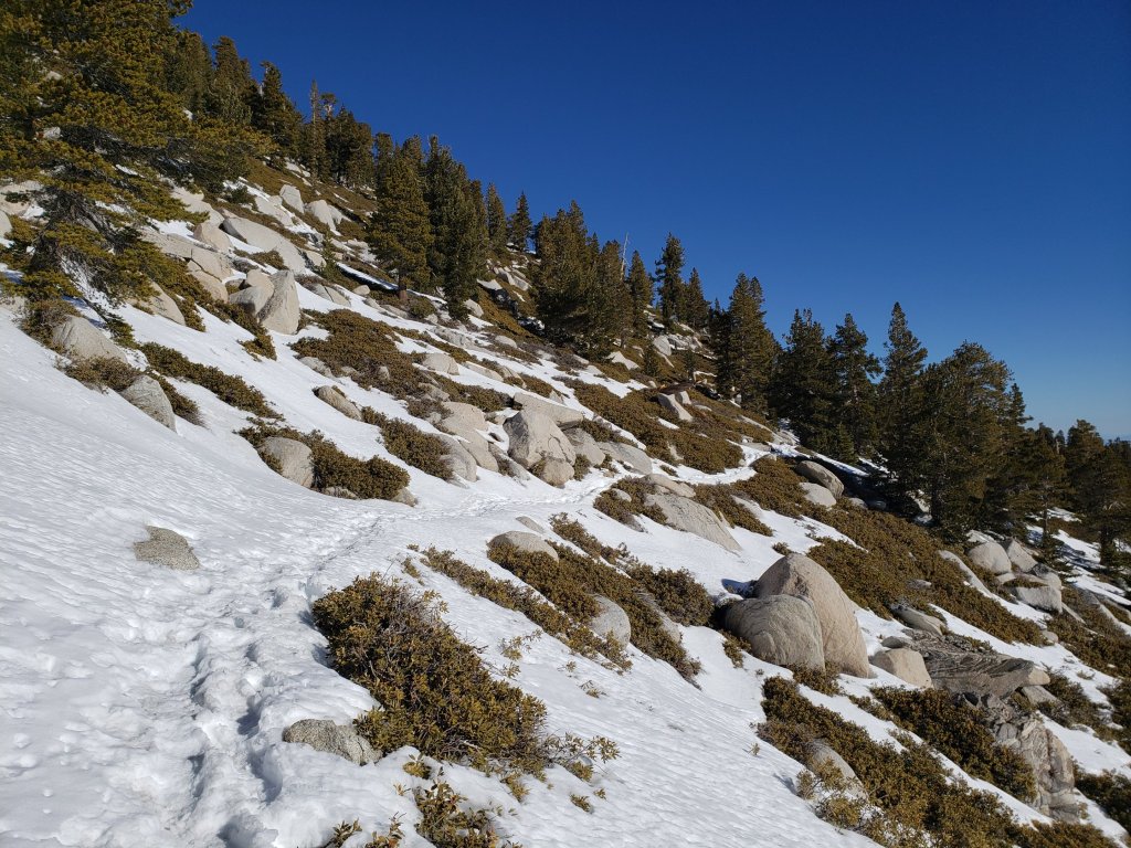
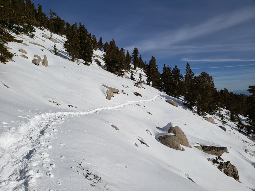
Deer Springs Trail is largely clear of snow up to Strawberry Junction and beyond to about 8600ft, but then snow is largely continuous from there to San Jacinto Peak. The track(s) above the Marion Mountain Trail junction are easy to follow, but are largely posthole tracks in places, and in several places do not accurately follow the true trail route. Above Little Round Valley the posthole track through the snow does not follow the trail route to San Jacinto Peak, and is steep and direct. Spikes are useful, and invaluable for descending, as snow is icy and compacted.
Marion Mountain Trail has extensive, very icy, snow cover to the PCT/Deer Springs Trail junction. Snow cover is roughly 50% below 7000ft and again above 8500ft, but is nearly continuous between those elevations. Spikes are strongly recommended.
Fuller Ridge Trail has not be traveled since the last snow (late January) and there are no tracks to follow.
Seven Pines Trail has had no visible hiker traffic this winter, nor since the most recent snowfall, with no tracks or trail to follow. Indeed this trail has been hiked very little since November 2018. Extremely cautious navigation is recommended for those who are not very familiar with hiking this trail. The Forest Service closure of Dark Canyon Road continues, and there is no vehicular access to Seven Pines trailhead.
The Ernie Maxwell Trail is almost completely clear of ice and snow, a couple of extended patches remain near Humber Park. Spikes are not required.
South Ridge Trail is essentially clear to Old Lookout Flat at 7600′, with just a few tiny icy patches low down. Snow cover averages 30% on the traverse at 7600-7800ft, and then only 10% from there to Tahquitz Peak. Spikes can be useful for descending the uppermost switchbacks close to Tahquitz Peak. South Ridge Road (currently closed) is basically clear, with a few tiny ice patches remaining.
Skyline Trail is clear of snow to about 7300ft, thereafter snow is fairly shallow but continuous to Grubb’s Notch (8600ft). There is a well-worn but icy track to follow, spikes are strongly recommended.
Current snow cover on the PCT is minimal from Miles 151 (Highway 74) to about 160, and patchy between Miles 160 and about 175 (Red Tahquitz), mainly concentrated on north-facing slopes e.g., Spitler Peak (Mile 168) and Apache Peak (Mile 169.5-170). Note that in addition to the challenging north-east side of Apache Peak, the off-trail north side of the Apache saddle is also still largely snow-covered (also requiring spikes). Snow is then more-or-less continuous between Miles 175-178. Snow cover is increasingly patchy and limited between Miles 178 to 183.5, with the exception of the notoriously stubborn half mile just south of Annie’s Junction at about Mile 181. From Mile 183.5 to 191, snow is largely continuous, although some exposed sections of Fuller Ridge (e.g., parts of Miles 186.5-188.5) are clear or thinning rapidly.
Spitler Peak Trail is basically clear of snow, with just a couple of tiny icy patches remaining.
Cedar Spring Trail is clear of snow from Morris Ranch Road to the PCT, with some small patches remaining down to the spring itself.
SNOW DEPTHS measured at east side locations on 22nd February 2021 are as follows. Note that average depth is given first, followed (in parentheses) by the greatest depth of this winter recorded on 31st January. Due to past drifting, and variable melting due to differential sun exposure, depths now vary greatly in trails especially. Altitudes are approximate.
San Jacinto Peak (10810ft): 19 inches (40 inches on 31st January)
Wellman Divide (9700ft): 6 inches (31 inches on 31st January)
Annie’s Junction (9070ft): 11 inches (29 inches on 31st January)
Strawberry Junction (8100ft): <1 inch on 19th February (24 inches on 31st January)
Saddle Junction/approx. PCT Mile 179.9 (8070′): 6 inches (29 inches on 31st January)
Devil’s Slide Trail at Humber Park (6550′): 0 inches (22 inches on 31st January)

San Jacinto Trail Report: available for everyone, funded by readers. While labor and time is volunteered, this Report completely depends on small private donations to cover its direct costs. With a busy winter overlapping with an unusually complex PCT season, every contribution is invaluable and deeply appreciated. If you have found this Report useful, please consider visiting the Donate page. Thank you.

One thought on “Snow and trail update 24th February 2021”