[UPDATED 4th February: Melting has been very rapid at low and mid elevations, steadier in the high country. Garner Valley and areas below 5000ft are basically clear, with sun-exposed slopes below 6000ft clearing fast. Idyllwild has lost 75% of its three feet of snow. At San Jacinto Peak this morning, I measured about 34 inches, a loss of 15%. Spikes are invaluable on all well-traveled trails above at least 6000ft, snowshoes are recommended above 8000ft, and are essential for off-trail travel anywhere above 7000ft. Melting will accelerate rapidly, as temperatures are forecast to be about ten degrees above average at all elevations for the next 5-6 days.]
Our seventh snow storm of winter 2020/21, and the third in one week, came on Friday 29th January. In Idyllwild at 5550ft, seven inches fell overnight, with an additional 5.5 inches during the daylight hours of Friday. In combination with back-to-back storms the previous weekend (discussed here), Idyllwild received more than an entire winter’s worth of snow, 33.5 inches, in just one week (the long-term average being 32 inches per winter).
Conditions on my ascent to San Jacinto Peak on 31st January are described in more detail in yet another overly long and rambling video discussion (I’ll learn to talk less soon I promise). I ascended via the east side trails (Devil’s Slide, Wellman, and Peak trails) and descended the west side via Deer Springs Trail. Snow conditions were greatly improved compared to just five days ago, with the fresh snow being much more consolidated and firm, with snowshoes only sinking in a few inches rather than feet.
Yet again, there was little difference in snowfall between the mid and upper elevations, with actually slightly less fresh snow in this latest storm at San Jacinto Peak (10,810ft) than in Idyllwild (at 5550ft), probably because the high country was above the clouds for some of the storm system. Snow depths measured today are listed at the foot of this posting. Although excellent tracks are in place on some major trails (discussed below), nevertheless cautious navigation is strongly recommended everywhere.
Snow depths are currently ideal for snowshoeing everywhere above about 6000ft, potentially lower on less exposed trails that will melt slowly. With rapid melting expected, and compaction caused by freeze-thaw cycles and hiker traffic, conditions will deteriorate for snowshoeing over the next few days, especially on more heavily traveled trails below 8000ft. Nevertheless, snowshoes will be invaluable anywhere off trail above about 8000ft for the foreseeable future. In addition to snowshoes, and as conditions change, spikes are strongly recommended for the foreseeable future everywhere above about 4500ft. They will be especially valuable on well-consolidated tracks (e.g., Devil’s Slide and Deer Springs trails) on colder mornings when conditions are icy, and for decsending.
Consolidation of layers in the snow should be rapid with warming temperatures and a strong February sun over the next week. The avalanche risk in the high country has diminished due to the relatively shallow snow depth, but should still be considered by anyone venturing above 9000ft or especially on to steep north-facing slopes due to the large quantity of subsurface graupel. Be aware of subsurface whoomphing noises, and significant cracking perpendicular to the slope. Current risk is in the usual locations on the north face of San Jacinto and Tahquitz peaks, but in past years has also been observed on relatively steep, less vegetated slopes, such as the Peak Trail and East Ridge Trail routes on the eastern flank of San Jacinto Peak.
Despite unseasonably warm temperatures in the high country for the next week or so, hikers should be prepared for temperatures generally below freezing in the high country, and well below freezing when considering wind chill effects.
The USFS gate at Humber Park is closed. There is legal parking for nine vehicles only just below the gate (assuming the road below that point is open). Vehicles parked there this weekend were issued with warning notices by California Highway Patrol. On weekends this year (and some weekdays) the uppermost 0.1 mile of Fern Valley Road has usually been closed by CHP at its junction with Forest Drive. Although parking is normally legal along Forest Drive, CHP has towed vehicles parked along that street on recent weekends. Exercise considerable caution when parking anywhere in this area.
The gate on South Ridge Road is closed. The unpaved section of Tahquitz View Drive has now been plowed, and there is safe parking on Tahquitz View Drive at or near the foot of South Ridge Road for a small number of vehicles.
Azalea Drive, the access road to Marion Mountain trailhead, has not been ploughed. The USFS gate about 0.5 mile below the trailhead is closed.
All camping is prohibited in Mount San Jacinto State Park, where the four wilderness camping areas in the State Park remain closed (camping is never permitted elsewhere in the State Park). Wilderness camping appears to now be permitted in the National Forest. See the State Park or Forest Service websites for further information.
WEATHER A warming trend to temperatures slightly above seasonal (especially at higher elevations) will lead to significant melting in the first week of February. Next weekend, 6th-7th February, temperatures are currently forecast to be well above seasonal, and melting will accelerate at all elevations.
At San Jacinto Peak (10,810ft/3295m) today, Sunday 31st January 2021 at 0950 the air temperature was 37.8°F (3°C), with a windchill temperature of 31.9°F (0°C), 35% relative humidity, and a very light due West wind sustained at 2 mph gusting to 5.6 mph.
At the Peak on Tuesday 26th January 2021 at 1350 the air temperature was 9.8°F (-12°C), with a windchill temperature of -9.6°F (-23°C), 66% relative humidity, and a bitter due West wind sustained at 11 mph gusting to 14.9 mph.

TRAIL CONDITIONS
All trails above about 4500′ are snow-covered. Snow was melting rapidly this afternoon at all elevations, but especially below 6500ft. At all elevations by this afternoon snow was softening rapidly, and was taking on the consistency of soft-serve ice cream even in the high country. This makes snowshoes even more invaluable. The hikers I encountered postholing on Deer Springs Trail this afternoon were not having a good time.
There were no visible hiker tracks on Marion Mountain, Seven Pines, or Fuller Ridge trails, as of this afternoon.
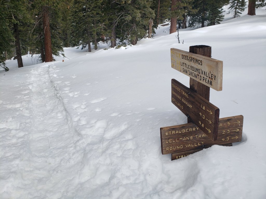
The east side trails from Humber Park to San Jacinto Peak – Devil’s Slide, Saddle Junction to Annie’s Junction, Wellman, and Peak trails – all have a very well-defined snowshoe track to follow, although the route does not exactly follow the established trail routes in the high country in places.
Deer Springs Trail has an excellent snowshoe track to follow to Little Round Valley, largely accurately following the established trail route. Above Little Round Valley, my snowshoe track down from the Peak is very direct, steep, and would be a challenging ascent.
There is well-defined track on the Suicide Rock Trail through the snow from Deer Springs Trail to the top of Suicide Rock.
Tahquitz Peak trail from Chinquapin Flat/PCT Mile 178 had no steps to follow through the steeply angled icy snow as of this morning. These icy slopes are notoriously treacherous. Currently crampons with an ice axe (and knowledge of how to use both) are required. Snowshoes are not advised due to the angle of the icy snow.
South Ridge Road and upper South Ridge Trail have a track to follow to Tahquitz Peak.
The Ernie Maxwell Trail has a well-defined snowshoe track.
SNOW DEPTHS measured on 31st January 2021, are as follows. Note that current average total depth is given first, followed by added snow from the latest storm in parentheses where known. Note that there was some melting between the previous storm systems, accounting for the discrepancy between depths reported here and last weeks report. Due to strong winds accompanying the storms there is extensive drifting, especially in the trails. Altitudes are approximate.
San Jacinto Peak (10810ft): 40 inches (8 inches new snow in latest storm)
Little Round Valley (9800ft): 32 inches
Wellman Divide (9700ft): 31 inches (7 inches new)
Annie’s Junction/approx. PCT Mile 181.8 (9070ft): 29 inches (10 inches new)
Deer Springs Trail at Seven Pines Trail junction (8700ft): 26 inches
Strawberry Junction (8100ft): 24 inches
Saddle Junction/approx. PCT Mile 179.9 (8070′): 29 inches (10 inches new)
Deer Springs Trail at Suicide Rock Trail junction (6950ft): 16 inches
Devil’s Slide Trail at Humber Park (6550′): 22 inches (12 inches new, but melting rapidly)
Idyllwild (at 5550′): 18 inches (all new; although 33 inches fell, rapid melting was already underway yesterday)
San Jacinto Trail Report: available for everyone, funded by readers. While all labor and time is volunteered, this Report completely depends on small private donations to cover its costs. Already deep into a very busy winter, every contribution is invaluable. If you have found this Report useful, please consider visiting the Donate page. Thank you.

Very nice post with good description!
The north face of Tahquitz Peak looks really interesting.
Are there any established climbing routes?
LikeLike
Thank you for that very descriptive report.
LikeLike