[UPDATED 29th January: An additional seven inches of snow fell overnight in Idyllwild (at 5550ft) and it has continued to snow on/off all day, adding 5.25 more inches. Long Valley (8600ft but on the east slope) has added only about 5-6 inches in this storm. The next full high country update is planned for Sunday evening, 31st January.]
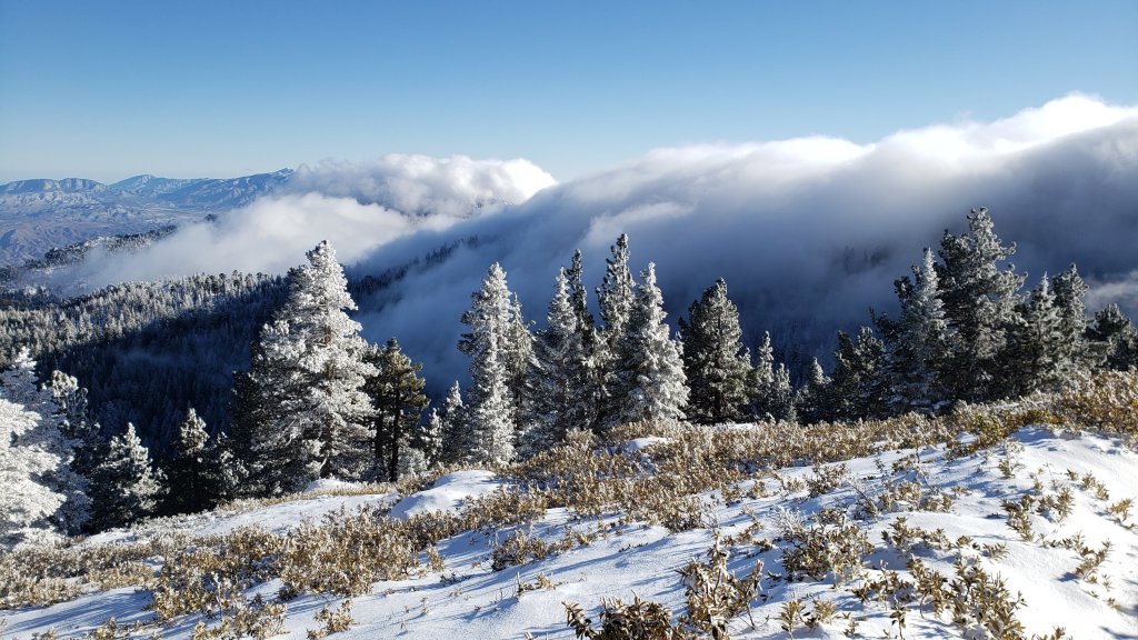
This is a summary of conditions following the fifth and sixth snow storms of winter 2020/21, which came on consecutive days, largely overnight on 24th and 25th January. As is increasingly the trend with a rapidly changing climate in recent years, there was relatively little difference in snowfall between the mid and upper elevations, with a combined storms total of 20.75 inches measured in Idyllwild (at 5550ft) through to 26 inches at San Jacinto Peak (10,810ft). The second of the two storm systems was much colder than the first, accounting for about 75% of the snow total, and with a dusting of snow below 2000ft in places.
My ascent to San Jacinto Peak this morning is described in more detail in a video discussion available here. Overall it was unusually challenging due to substantial depth of graupel, mainly above 10,000ft. This made for exceptional postholing in snowshoes even though overall snow depths remain below average for the season.
Currently major trails have not been traveled and all are obscured by significant snowfall. Beyond Humber Park, at the time of writing, my snowshoe tracks to San Jacinto Peak are the only traveled high country trail. On my descent this evening, I was surprised to see no other tracks up to Saddle Junction. The significance of this is that there are currently no tracks on Willow Creek Trail, to Chinquapin Flat or Tahquitz Peak, or around the meadows. Very cautious navigation is strongly recommended everywhere. Snow depths measured today are listed at the foot of this posting, but note that due to drifting, snow can be deeper in the trails themselves.
Snow depths are currently ideal for snowshoeing everywhere above about 5000ft, potentially lower on less exposed trails that will melt slowly. Elsewhere (and in addition), spikes are recommended for the foreseeable future as established trails become consolidated by hiker traffic and undergo freeze-thaw cycles.
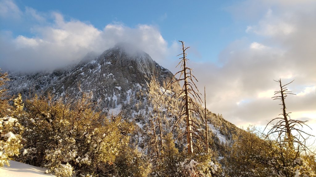
There is now an avalanche risk in the high country. Graupel is inherently unstable, especially when the layer is so thick, and this will be exacerbated by a heavy fresh snowfall on 28th-29th January. On my descent of the East Ridge of San Jacinto Peak this afternoon I had several major whoomphing events underfoot (yes, that is actually a technical avalanche term!) due to major subsurface cracking. Current risk is in the usual locations on the north face of San Jacinto and Tahquitz peaks, but may spread to other relatively steep, less vegetated slopes, such as the eastern flank of San Jacinto Peak.
Hikers should be prepared for temperatures below freezing in the high country, and far below freezing when considering wind chill effects.
The USFS gate at Humber Park is closed. There is legal parking for nine vehicles only just below the gate. Weekends this month (and some weekdays) the uppermost 0.1 mile of Fern Valley Road has also been closed at its junction with Forest Drive. Although parking is normally legal along Forest Drive, CHP has towed vehicles parked along that street on recent weekends.
The gate on South Ridge Road is also closed. Due to snow berms there is currently no parking on Tahquitz View Drive at the foot of South Ridge Road.
Azalea Drive, the access road to Marion Mountain trailhead, has not been ploughed.
The Deer Springs trailhead at Highway 243 has not been ploughed. There is safe roadside parking for only 12-14 vehicles.
All developed and yellow post camping is closed in the San Jacinto Ranger District of the San Bernardino National Forest. This was initially due to exceptional fire risk, but more recently due to the coronavirus crisis. All camping is prohibited in Mount San Jacinto State Park, where the four wilderness camping areas in the State Park remain closed (camping is not permitted elsewhere in the State Park). Wilderness camping appears to now be permitted in the National Forest. See the State Park or Forest Service websites for further information.
WEATHER Temperatures are forecast to remain below seasonal for at least the next week, with freezing conditions every night above about 5000ft. Snow melt will be very limited, and conditions will be icy. Another storm system arrives on the night of Thursday 28th, with snow continuing Friday 29th. This will be the warmest of the three recent storms, with a further 6-8 inches of snow forecast everywhere above about 5500ft (with 12+ inches possible in the high country) but significant rainfall below that elevation.
At San Jacinto Peak (10,810ft/3295m) today, Tuesday 26th January 2021 at 1350 the air temperature was 9.8°F (-12°C), with a windchill temperature of -9.6°F (-23°C), 66% relative humidity, and a bitter due West wind sustained at 11 mph gusting to 14.9 mph.
TRAIL CONDITIONS
All trails above about 4000′ are snow-covered. The light dusting of snow below that elevation was melting rapidly this afternoon.
Tahquitz Peak trail from Chinquapin Flat/PCT Mile 178 has no steps to follow through the steeply angled icy snow. These icy slopes are notoriously treacherous. Currently crampons with an ice axe (and knowledge of how to use both) are required. Snowshoes are not advised due to the angle of the icy snow.
The Ernie Maxwell Trail has a well-defined snowshoe track. The lower trailhead on Tahquitz View Drive is not currently accessible to vehicles as the road is unploughed.
Devil’s Slide Trail has a well-defined snowshoe track to follow.
SNOW DEPTHS measured on 26th January 2021, are as follows. Note that average total depth is given first, followed by depth from latest storms in parentheses. Due to strong winds accompanying the storms there is extensive drifting, especially in the trails. Altitudes are approximate.
San Jacinto Peak (10810′): 34 inches (26 inches new in latest storms)
Wellman Divide (9700′): 24 inches (18 inches new)
Annie’s Junction/approx. PCT Mile 181.8 (9070′): 23 inches (17 new)
Saddle Junction/approx. PCT Mile 179.9 (8070′): 21 inches (20 inches new)
Devil’s Slide Trail at Humber Park (6550′): 18 inches (17 inches new)
Idyllwild (at 5550′): 20.75 inches (all new)
San Jacinto Trail Report: available for everyone, funded by readers. While all labor and time is volunteered, this Report completely depends on small private donations to cover its costs. In an especially challenging year, and with a busy winter already well underway, every contribution is invaluable. If you have found this Report useful, please consider visiting the Donate page. Thank you.

I snowshoed up Devils to the saddle on Weds the 27th and viewed only one other set of tracks. The powder and solitude was a nice change but lots of work. Looks like I might have just missed you! Lol Take care n thanks so much for the updates.
LikeLike