Recent hikes have included four ascents of San Jacinto Peak in the past six days via several routes, plus Tahquitz Peak and a check of water sources in the Tahquitz area meadows. Wild North winds overnight produced a lot of branches down on the trails today (I removed those I found). Assessment of any new downed trees forestwide may take a few weeks, but be aware of the possibility of new tree fall hazards.
Although yet another warming trend starts tomorrow, hikers should now be prepared for temperatures around freezing in the high country, and below freezing when considering windchill effects (see recent recorded temperatures below). Cloudy conditions at mid elevations in recent days failed to produce significant precipitation in the mountains.
Due to continuing exceptional fire risk, all dispersed camping remains prohibited in both the Mount San Jacinto State Park and the San Jacinto Ranger District of the San Bernardino National Forest. No wilderness camping (including anywhere along the PCT) or camping at yellow post sites (such as those along Black Mountain Road and South Ridge Road) is permitted. Day hiking permits are available at the Idyllwild and Long Valley ranger stations of the Mount San Jacinto State Park, which are both open. The U.S. Forest Service ranger station in Idyllwild remains closed due to the coronavirus crisis. USFS day use permits are required for the San Jacinto wilderness, and should be available at the kiosk outside the ranger station.
Palm Springs Aerial Tramway, which closed 13th March due to the coronavirus crisis, partially reopened on 9th October. Trams are operating at greatly reduced capacity, reduced times, and on limited days; see the Tramway website for details.
Black Mountain Road was graded in June through to the Fuller Ridge campground. Boulder Basin campground (and the Black Mountain Group campground) will remain closed into 2021. South Ridge Road was partially graded in the first week of September, and is now readily passable.
Water conditions have not significantly changed from those described in last week’s Report.
WEATHER After a long, hot summer, including much of October, we had a delightful, if brief, hint of winter, with temperatures falling to well below seasonal average over the past four days. However, temperatures will rise rapidly this week, and especially in the first week of November they are forecast to be well above average yet again. There continues to be no significant precipitation in the forecast. Fire risk remains severe.
An extremely light drizzle was reported in some areas around Idyllwild-Pine Cove on Sunday 25th, with 0.02″ measured at 5550′ elevation. The high country was above the cloud, with no precipitation above about 6500′.
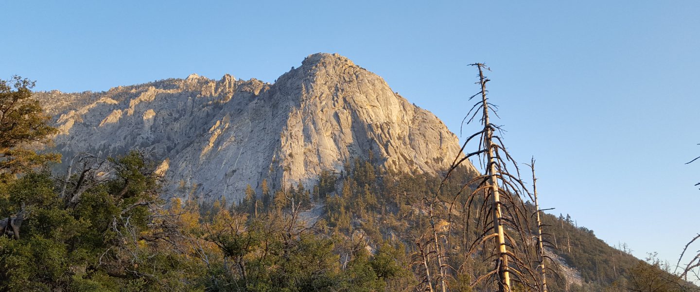
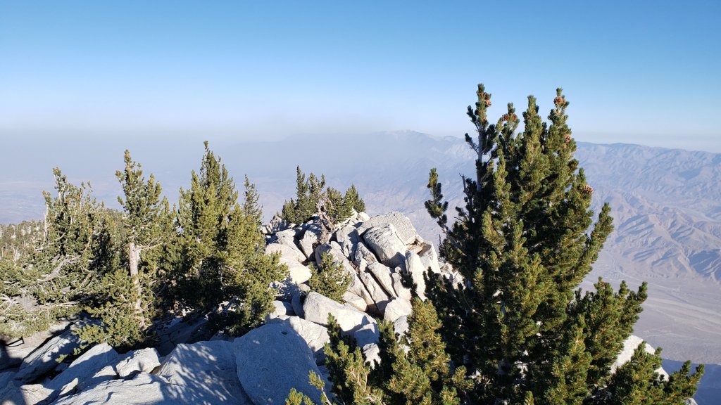
Air quality had largely returned to normal in the high country, but strong North winds on Monday 26th stirred up all the smoke, ash, and dust again. Ash was flying around San Jacinto Peak yesterday morning, having blown up the north face from the Snow Fire scar 6000 feet below. Conditions had started to improve today (see comparison photos below).
At San Jacinto Peak (3295m/10,810ft) on Tuesday 27th October 2020, at 0900 the air temperature was 24.6°F (-4°C), with a windchill of 4.1°F (-16°C), 46% relative humidity, and a bitter due North wind sustained at 20 mph gusting to 27.3 mph.
At the Peak on Monday 26th October 2020, at 0840 the air temperature was 23.3°F (-5°C), with a windchill of -0.4°F (-18°C), 13% relative humidity, and a blustery due North wind sustained at 18 mph gusting to 24.8 mph.
TRAIL CONDITIONS
The Pacific Crest Trail above Snow Creek (approx. PCT Miles 198-206) was burned on both sides by the Snow Fire (17th-19th September 2020). A closure order for the burn scar means that the Trail remains closed between Snow Creek and Black Mountain Road (approx. Miles 191-206).
The Pacific Crest Trail remains open at the rockslide just north of Antsell Rock (Mile 172.5). USFS plans for removal of the rockslide have been delayed due to the coronavirus crisis. The video report (available here) can be useful for deciding whether to hike around the rockslide or take an alternate route.
Many trails have treefall hazards remaining from last winter, passable for hikers but not for stock. Some are described in detail below, others include: PCT south of Red Tahquitz (approx. PCT Miles 173-175), PCT between Strawberry Cienega and Deer Springs camp (Miles 182-185), Fuller Ridge Trail near its northern end (PCT Miles 189.1-190.2), Spitler Peak, Cedar Spring, and Apache Spring trails. All significant tree hazards on Willow Creek Trail have now been removed.
Seven Pines Trail has been very lightly traveled since November 2018. There are 25 treefall hazards on the trail, almost all in the upper State Park section of trail, based on multiple June 2020 surveys. Very cautious navigation is recommended for those unfamiliar with this trail. The Forest Service closure of Dark Canyon Road will continue into 2021, so there is currently no vehicular access to Seven Pines trailhead.
Forest Service temporary signage indicates that the Caramba Trail from near Reeds Meadow through Laws Camp and on to Caramba, and the Cedar Trail from Willow Creek Trail to Laws, are “not maintained”. In reality both trails barely exist. Both are so heavily overgrown I advise hikers do not attempt to follow them. Many experienced hikers have reported getting lost in this area since summer 2019. An informal use trail to Laws is much more direct and avoids all of the challenging bush-whacking of the unmaintained trails (some local hikers have dubbed it the “King Trail”). It leaves the Willow Creek Trail exactly 1.0 mile from Saddle Junction (0.46 mile from the Skunk Cabbage turning), descending largely on established deer trails for 1.2 miles, roughly paralleling Willow Creek just to its south. Be advised that it is an indistinct use trail, becoming less obvious as it nears Laws (by which time Willow Creek is close by on your left hand side, so navigation is not a challenge). From Laws east to Caramba the route of the original Caramba Trail is relatively easy to follow (for those who were familiar with this trail prior to the 2013 Mountain Fire) despite USFS information to the contrary. Nevertheless, cautious navigation is still advised.

San Jacinto Trail Report: available for everyone, funded by readers. While all labor and time is volunteered, this Report completely depends on small private donations to cover costs. With an especially challenging year in 2020, every contribution is invaluable. If you have found this Report useful, please consider visiting the Donate page. Thank you.
