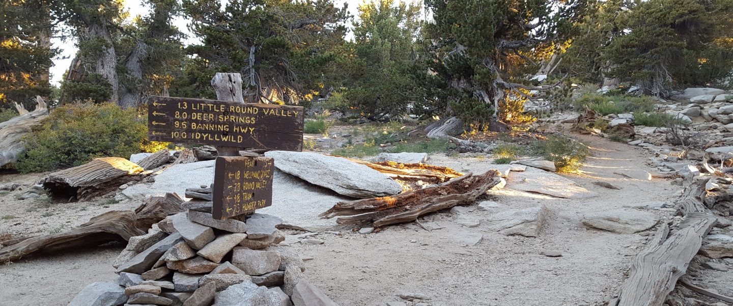
I have continued to hike up San Jacinto Peak every morning since 1st May, by as many diverse routes as possible. For example on Sunday I surveyed downed trees on Fuller Ridge Trail, and yesterday took a circuitous descent via Willow Creek Trail, where I again helped Forest Service volunteer Bill clear thick whitethorn, a project which is nearing completion.
I was encouraged by a conversation with two young hikers at San Jacinto Peak early this morning. They commented how clear of trash the trails were up here compared to other mountains they had hiked in Southern California. Clearly a hiker who systematically picks up every piece of trash they find, especially when they hike a rotation of trails every single day, can make a genuine difference to everyone’s trail experience.
Snow is now gone from the trail system, and water is, for now, flowing well where expected, as updated in detail at the foot of this post.
Black Mountain Road reopened on 20th June, having been graded through to the Fuller Ridge campground. USFS indicates that Boulder Basin campground will remain closed until next year.
Palm Springs Aerial Tramway is closed indefinitely (since 12th March) due to the coronavirus crisis.
Limited camping is now available in Mount San Jacinto State Park, see their website for details. The U.S. Forest Service ranger station in Idyllwild remains closed. Although Forest Service wilderness camping and hiking permits can be issued if requested, they are currently not required. USFS campgrounds are now open, except those discussed below.
WEATHER Above seasonal June temperatures continue to this weekend, followed by a very significant cooling between Sunday 28th June and Wednesday 1st July, before another rapid warming in early July. There is no precipitation in the forecast.
At San Jacinto Peak (3295m/10,810ft) today, Wednesday 24th June 2020, at 0800 the air temperature was 55.8°F (13°C), with a windchill of 53.8°F (12°C), 21% relative humidity, and a light SW wind sustained at 2 mph gusting to 8.2 mph.
The coolest recent day at the Peak was Friday 19th June 2020, when at 0755 the air temperature was 46.5°F (8°C), with a windchill of 37.8°F (3°C), 52% relative humidity, and a brisk due East wind sustained at 8 mph gusting to 20.2 mph.
The warmest day of 2020 so far recorded at San Jacinto Peak was Monday 22nd June, when at 0830 the air temperature was 57.0°F (14°C) with 37% relative humidity and a barely discernible SW wind gusting to 2.9 mph.
TRAIL CONDITIONS
All trails have been clear of snow since early June. Many trails have new treefall hazards from this past winter, passable for hikers but not for stock. Some are described in detail below, others include: PCT south of Red Tahquitz (approx. PCT Miles 173-175), PCT between Strawberry Cienega and Deer Springs camp (Miles 182-185), Fuller Ridge Trail near its northern end (PCT Miles 189.1-190.2), Spitler Peak, Cedar Spring, and Apache Spring trails.
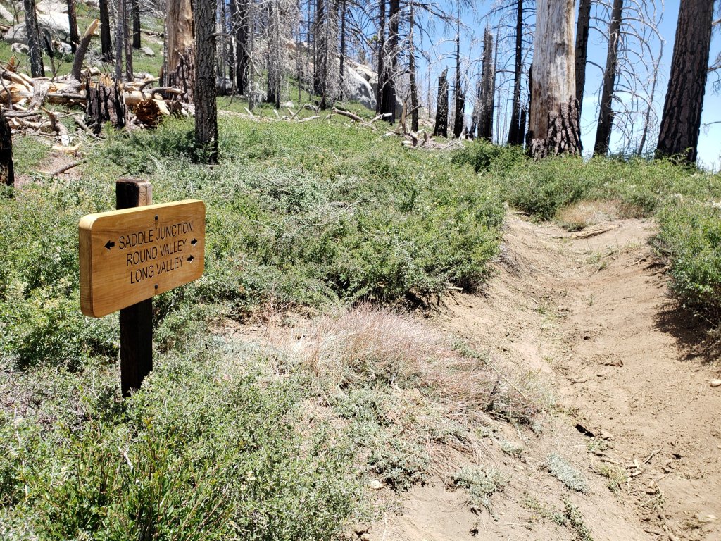
Willow Creek Trail [updated 27th June] has 15 tree hazards (4 on Forest Service land, 11 on State Park) between Willow Creek and Hidden Divide from this past winter. Nine additional trees on Forest Service land between Saddle Junction and Willow Creek have been cleared since late May. Great progress has also been made on whitethorn removal, with the trail now clear on the State Park side and clear on the Forest Service section as far as the old Laws junction (see photo below).
Seven Pines Trail has been very lightly traveled since November 2018. There are 25 treefall hazards on the trail, almost all in the upper State Park section of trail, based on multiple May/June 2020 surveys. Very cautious navigation is recommended for those unfamiliar with this trail. The Forest Service closure of Dark Canyon Road is expected to continue into 2021, so there is currently no vehicular access to Seven Pines trailhead.
The Pacific Crest Trail remains open at the rockslide just north of Antsell Rock (Mile 172.5). USFS has not indicated when this area may close for removal of the rockslide. The video report (available here) can be useful for deciding whether to hike around the rockslide or take an alternate route.
Forest Service temporary signage indicates that the Caramba Trail from near Reeds Meadow through Laws Camp and on to Caramba, and the Cedar Trail from Willow Creek Trail to Laws, are “not maintained”. In reality both trails no longer exist. Both are so heavily overgrown I advise hikers do not attempt to follow them. Many experienced hikers have reported getting lost in this area since summer 2019. An informal use trail to Laws has been developed which is much more direct and avoids all of the challenging bush-whacking of the unmaintained trails (some local hikers have kindly named it the “King Trail”). It leaves the Willow Creek Trail exactly 1.0 mile from Saddle Junction (0.46 mile from the Skunk Cabbage turning), descending largely on established deer trails for 1.2 miles, roughly paralleling Willow Creek just to its south. Currently it is indistinct, becoming even less obvious as it nears Laws (by which time Willow Creek is close by on your left hand side, so navigation is not a challenge). I hope to work on the trail in early July. From Laws east to Caramba the route of the original Caramba Trail is relatively easy to follow (for those who were familiar with this trail prior to the 2013 Mountain Fire). Nevertheless very cautious navigation is still advised.
WATER STATUS: Eastern slope
The Round Valley pipe is not currently flowing. The flow as been redirected to the CCC camp in Long Valley and water pressure is insufficient to also flow at the pipe. Fortunately Round Valley creek just a few yards away is flowing, but will likely dry up in July.
Both the northern and southern springs at Wellman’s Cienega are flowing gently, but flow rates have dropped considerably in recent weeks. These are the sources for Willow Creek, which is flowing very well where it crosses the Willow Creek Trail.
Tahquitz Valley is flowing.
Tahquitz Creek is flowing well at the northern end of Little Tahquitz Meadow. It is also flowing well further upstream at its source (known locally as Grethe Spring) where it crosses the PCT (approx. PCT Mile 177).
Candy’s Creek – that flows through Skunk Cabbage Meadow and then crosses the Caramba Trail near Reeds Meadow – is currently flowing well.
WATER STATUS: Western slope
The North Fork of the San Jacinto River is flowing very well where it crosses the Deer Springs Trail and even better where it crosses the Fuller Ridge Trail on the PCT (approx. PCT Mile 186.2).

The creek in Little Round Valley is flowing, although at less than half the volume compared to this time last year. The same creek is flowing well where it crosses Fuller Ridge Trail (at about PCT Mile 186.4).
Shooting Star Spring (below Little Round Valley but above the North Fork of the San Jacinto River crossing) is flowing well.
The Deer Springs stream crossing at the PCT (approx. PCT mile 185.6) is flowing strongly.
Switchback Spring at PCT Mile 183.5 (about 0.4 miles north of Strawberry Junction) is flowing well, but there is little depth in which to filter water.
The little creek at Strawberry Cienega (PCT mile 183.0) is flowing.
On Devil’s Slide Trail, Middle Spring is flowing well, but flow rate is only 10% compared to less than a month ago. Powderbox and Jolley springs, and the several unnamed ephemeral creeks on this trail, have functionally dried up.
On the Ernie Maxwell Trail, the crossing of Chinquapin Creek just below Humber Park continues to flow well (an important source of water for the many dogs walked on this trail) [thanks to Anne and Anabel for checking this on their run this morning].
WATER STATUS: Desert Divide
Live Oak Spring (N 33 37 21, W 116 33 24) Flowing well. The most reliable water source on the Desert Divide.
Cedar Spring (N 33 40 36, W 116 34 35) Flowing well. Easiest access is the trough just upstream from the trail to the campsite.
Apache Spring (N 33 43 11, W 116 37 13) Flowing fairly well.
Spitler Peak Trail Descending the trail there are five water crossings. The first two, at 0.9 and 0.95 miles down, cross a tiny side creek which is largely dry and should be ignored. The next crossing, at 1.1 miles down, is Spitler Creek and is the best source of water (currently flowing well). The next two crossings are the same creek, but for obvious reasons it is best to fill up at the highest of the three crossings.
Antsell Rock Creek (N 33 41 52, W 116 39 08) Right by the Spitler Peak Trail trailhead on Apple Canyon Road, Antsell Rock Creek is flowing very well. Just on the upstream side of the road there is excellent access to the creek. Useful if hikers are descending the Spitler Peak Trail.
San Jacinto Trail Report: available for everyone, funded by readers. While all labor and time is volunteered, this Report completely depends on small private donations to cover its direct costs. With a very challenging first few months of 2020, every contribution is invaluable. If you have found this Report useful, please consider visiting the Donate page. Thank you.

One thought on “Trail and water update 24th June 2020”