We have hiked to San Jacinto Peak every day so far in May, using several different routes, including an east-west loop ascending the Peak Trail and descending Deer Springs Trail on Monday, via Marion Mountain Trail yesterday, and a circuitous route via Willow Creek and Round Valley trails today.
Very warm weather last week caused extensive snowmelt at all elevations, with all trails partly or completely clearing. Pleasantly cool weather so far this week has resulted in firm icy snow in the mornings, with easy hiking conditions where areas of snow remain. On sunny afternoons, snow can still be soft, and caution is advised on soft snow melting away from rocks and logs, and over running water. Potentially ankle-breaking posthole conditions remain widespread in such areas.
Where snow remains in the high country, useable tracks through the snow are now in place for all major routes on the mountain. Measured snow depths, with comparison to the recent maximum depth, are listed at the foot of this posting.
Microspikes remain useful in some areas (discussed below) on colder early mornings, and for descending. Many hikers with suitable footwear (and hiking poles if preferred) may not need additional traction, depending on your willingness to potentially posthole in softening snow later in the day.
Despite mild weather at lower elevations, hikers should be prepared for temperatures near freezing in the high country, and below freezing when considering windchill effects.
Palm Springs Aerial Tramway is closed indefinitely (since 12th March) due to the coronavirus crisis. Black Mountain Road is closed by Forest Service order until 31st May.

WEATHER Temperatures are forecast to largely remain pleasantly cool – at or slightly above seasonal – into next week. There is no significant precipitation forecast for the foreseeable future, although there is the possibility of light drizzle at mid elevations on the afternoon of Monday 18th May.
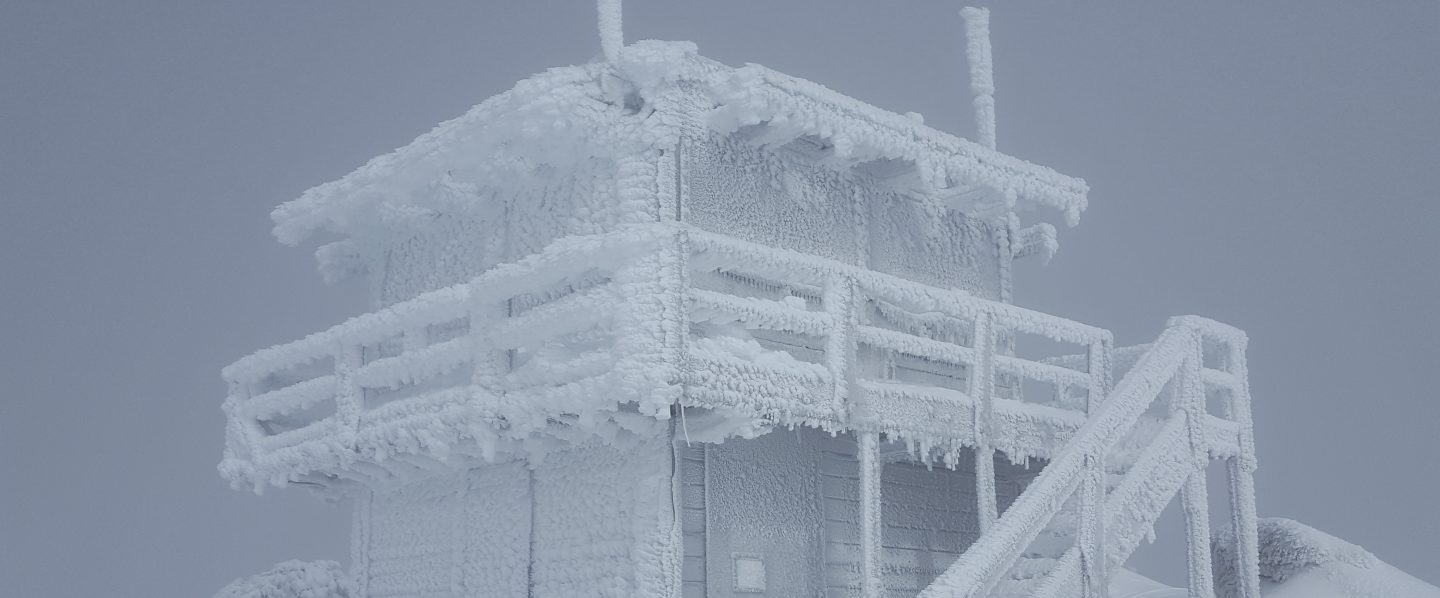
At San Jacinto Peak (3295m/10,810ft) today, Wednesday 13th May 2020, at 1020 the air temperature was 37.7°F (4°C), with a windchill of 31.8°F (0°C), 49% relative humidity, and a cool due West wind sustained at 5 mph gusting to 11.4 mph.
At the Peak on Tuesday 12th May 2020, at 0810 the air temperature was 31.0°F (-1°C), with a windchill of 15.1°F (-9°C), 76% relative humidity, and a biting due West wind sustained at 18 mph gusting to 31.8 mph.
The warmest day of the year to date recorded at the Peak was on Thursday 7th May 2020, when at 0810 the air temperature was 53.1°F (12°C), with a “windchill” of 50.5°F (10°C), 17% relative humidity, and a very light due West wind sustained at 2 mph gusting to 5.2 mph.
TRAIL CONDITIONS
All trails below about 9000′ are clear of snow, while higher trails have less than 50% snow-cover (see details below).
The following trails are now completely clear of snow: Ernie Maxwell, Devil’s Slide, Willow Creek, South Ridge, Marion Mountain, and Seven Pines. The Desert Divide south of Red Tahquitz (approx. PCT Mile 175), including side trails such as Spitler Peak, Cedar Spring, Apache Spring, Zen Centre, and Live Oak Spring trails, is all clear of snow. All of the latter have new treefall hazards from this winter, passable for hikers but not stock.
The Peak Trail above Wellman Divide is clear of snow, except for largely continuous drifted snow up to 1-2 feet deep for 0.2 mile around 10,000′, and in patches for 0.2 mile above 10,500′. The East Ridge Trail still has 90% drifted snow cover. The Wellman Trail is largely clear, except for 30% cover in the first 0.4 mile north from Annie’s Junction (at the State Park boundary).
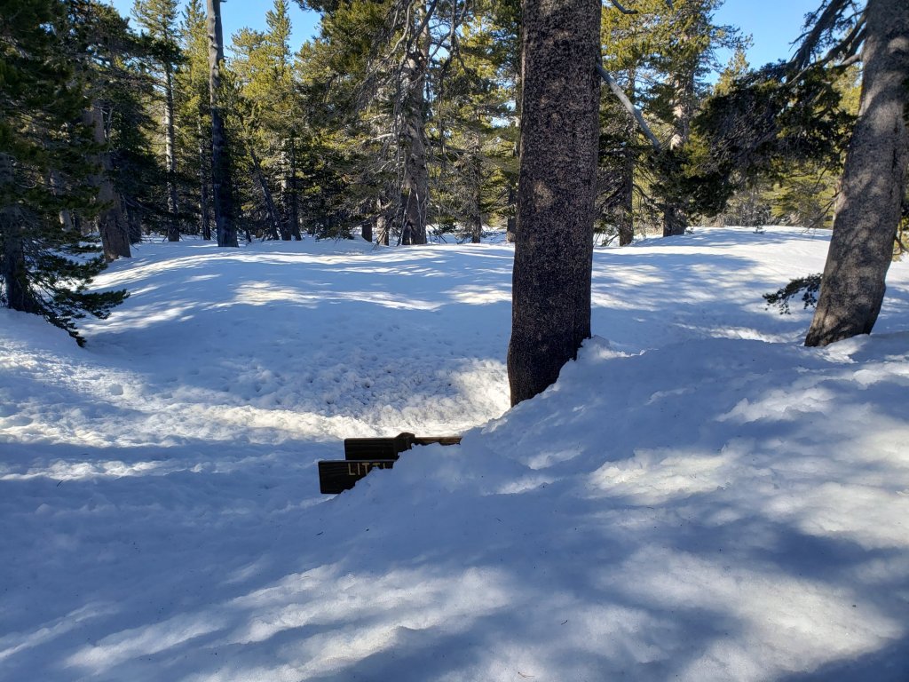
Deer Springs Trail is clear of snow to 9500′, except for a handful of tiny patches between the Seven Pines Trail and Fuller Ridge Trail junctions. There is a new major double treefall hazard right by the Deer Springs crossing. Snow cover is about 40% on the 0.4 mile from 9500′ to the crossing of the North Fork of the San Jacinto River, and it is then >95% clear for the final 0.2 mile ascent to Little Round Valley. Snow cover through Little Round Valley is 50%, and the tracks are somewhat meandering. Up to San Jacinto Peak snow cover is 30%. Although the trail above Little Round Valley is clearing rapidly, snow drifts make it hard to follow, while conversely melting makes it hard to follow the tracks through the snow. Microspikes are useful, especially for descending. San Jacinto Peak has barely 20% snow cover.
Willow Creek Trail is completely clear of snow, but has 24 new tree hazards between Saddle Junction and Hidden Divide from this past winter, based on a full survey undertaken 13th May. None are as large or as challenging to get around as in 2019, but some caution is recommended. The agencies have been notified.
Fuller Ridge Trail (PCT Miles 185.5-190.5) is largely clear of snow, although as usual extensive patches remain especially at the north end (Miles 188.6-190).
Round Valley Trail is largely clear to Round Valley, but from there to Wellman Divide still has about 60% coverage of shallow snow patches. Trail finding is currently tricky on that 1.0 mile section. The High Trail has about a dozen minor snow drifts still across the trail, and one major treefall hazard.
Tahquitz Peak trail from Chinquapin Flat/PCT Mile 178 [updated 16th May] is virtually clear of snow and has good steps to follow through the tiny patches that remain. Microspikes are no longer required.
Seven Pines Trail has a few very minor snow drifts near its junction with the PCT. This trail has only been hiked a handful of times since November 2018. Extremely cautious navigation is recommended for those who are not very familiar with hiking this trail. The Forest Service closure of Dark Canyon Road continues, and there is no vehicular access to Seven Pines trailhead.
WATER All major creeks and springs are currently flowing well, as are many ephemeral seasonal sources. Consequently I am not updating the water situation in detail at this time.

PACIFIC CREST TRAIL
The Pacific Crest Trail remains open at the rockslide just north of Antsell Rock (Mile 172.5). USFS has told the Trail Report that there are currently no plans to close this section of the PCT during spring 2020. The video report (available here) can be useful for deciding whether to try to hike around the rockslide or take an alternate route. All hikers this spring are reporting having no significant difficulty here.
PCT hikers are reminded that overnight stays are not permitted at or near San Jacinto Peak, including in the historic shelter. Mt. San Jacinto State Park regulations permit overnight stays only in established campgrounds (additionally, due to the Covid-19 crisis, no camping is currently allowed anywhere in the State Park).
SNOW DEPTHS measured 11th-12th May 2020 (with depth on 10th-12th April 2020 in parentheses for comparison where known). Note that average depth is given, drifts can be much deeper in places. Altitudes are approximate.
San Jacinto Peak (10810′): 5″ (was 40″ on 12th April)
Little Round Valley (9800′): 10″ (was 35″ on 12th April)
Wellman Divide (9700′): 0″ (was 32″ on 12th April)
Annie’s Junction (9070′): <1″ (was 35″ on 12th April)
Seven Pines Trail junction with Deer Springs Trail (8700′): 0″ (was 31″ on 11th April)
Long Valley (8600′): 0″ (was 16″ on 11th April)
Strawberry Junction (8100′): 0″ (was 25″ on 11th April)
Saddle Junction (8070′): 0″ (was 26″ on 11th April)
Devil’s Slide trailhead at Humber Park (6550′): 0″ (was 14″ on 11th April)

San Jacinto Trail Report: available for everyone, funded by readers.While all labor and time is volunteered, this Report completely depends on small private donations to cover its direct costs. With a very challenging first few months of 2020, every contribution is invaluable. If you have found this Report useful, please consider visiting the Donate page. Thank you.
