We have hiked to San Jacinto Peak every day so far in May, via several different routes, including loops ascending the Peak Trail and descending Deer Springs Trail today and on Saturday.
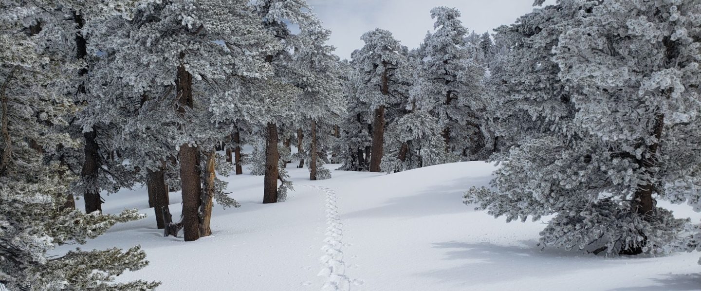
A couple of cooler days last weekend produced excellent firm icy snow in the early morning, and fast ascent conditions. By today, warmer temperatures kept the snow soft overnight, and the snow was quite unpleasant underfoot especially descending the western side from Little Round Valley to the top of Marion Mountain Trail. Over the next week or so, considerable caution is advised on soft snow melting away from rocks and logs, and over running water. Potentially ankle-breaking posthole conditions are currently widespread in such areas.
Summer-like temperatures on most days since about 25th April have radically changed hiking conditions. Most snow has gone below 9000′, with trails also clearing rapidly up to 10,000′, and in patches all the way to the highest peaks. Where snow remains in the high country, useable tracks through the snow are now in place for almost all major routes on the mountain.
Further temperatures more typical of July over the next few days mean that snowmelt will continue very rapidly, with most trails even at the highest elevations likely to be largely clear in the next ten days. Measured snow depths, with comparison to the recent maximum depth, are listed at the foot of this posting.
Microspikes can still be useful in some areas (discussed below) for hikers who are less comfortable on snow and ice, and in particular for descending. Many hikers with suitable footwear (and hiking poles if preferred) will not need additional traction, depending on your willingness to posthole in soft snow after early morning.
Due to apparent contradictions among, and inconsistent enforcement of, the various county, state, and federal rules and regulations during the coronavirus crisis, I recommend contacting relevant agencies directly for their latest information. According to their website, Mount San Jacinto State Park remains open only for local residents able to walk or bike to trailheads. Palm Springs Aerial Tramway is closed indefinitely (since 12th March).
WEATHER Temperatures overall remain unseasonably warm, over the next few days about 10-20°F above average for early May, according to the latest information from NWS San Diego. Very rapid snowmelt will continue at all elevations. Temperatures are forecast to drop to seasonal next week. There is no precipitation forecast for the foreseeable future.
At San Jacinto Peak (10,810ft/3295m) today, Tuesday 5th May 2020, at 0900 the air temperature was 49.2°F (10°C), with a windchill of 45.5°F (8°C), 21% relative humidity, and a light SW wind sustained at 3 mph gusting to 7.1 mph.
At the Peak on Monday 4th May 2020, at 0555 the air temperature was 44.3°F (7°C), with a windchill of 37.4°F (3°C), 8% relative humidity, and a steady due West wind sustained at 8 mph gusting to 11.8 mph.
The most recent cool day at the Peak was on Saturday 2nd May 2020, when at 0830 the air temperature was 34.3°F (1°C), with a windchill of 23.4°F (-5°C), 49% relative humidity, and a chilly due West wind sustained at 8 mph gusting to 13.9 mph.
TRAIL CONDITIONS
All trails above about 8900′ remain partly snow-covered, with depth depending on elevation (see below). Exposed slopes much higher – e.g. Wellman’s Cienega to Wellman Divide – are now clear. Some short sections of trails above about 8000′ may have remnant icy snow patches, depending on exposure.
The Desert Divide south of Red Tahquitz (approx. PCT Mile 175), including side trails such as Spitler Peak, Cedar Spring, Apache Spring, Zen Centre, and Live Oak Spring trails, is all clear of snow. All have new treefall hazards from this winter, passable for hikers but not stock.
The Peak Trail above Wellman Divide has about 30% snow cover, except for continuous cover of drifted snow about 1-2 feet deep around 10,000′ and again above 10,500′. The East Ridge Trail still has continuous drifted snow cover, also 1-2 feet deep. The Wellman Trail is largely clear, except for 90% cover in the first 0.4 mile north from Annie’s Junction.
Deer Springs Trail is clear of snow to Strawberry Junction, and north on the PCT almost to the Marion Mountain Trail junction (Mile 185) at about 8700′. Snow cover is about 50% from there to 9400′, where it increases to 80%. Snow cover through Little Round Valley to San Jacinto Peak is 90%, but melting has been dramatic even in the last four (coolish) days. Tracks through the snow do not follow the trail route to San Jacinto Peak, but are adequate. Microspikes are useful for descending.
Marion Mountain Trail is basically clear of snow to the PCT/Deer Springs Trail, with just a few small patches remaining above 8500′.
South Ridge Trail is clear to Tahquitz Peak, other than a few tiny snow patches above 8600′. Microspikes are no longer required.
Fuller Ridge Trail (PCT Miles 185.5-190.5) is rapidly clearing of snow, although as usual extensive patches remain especially near the south (185.5-186.5) and north (188..6-190) ends.
Round Valley Trail is largely clear, but through to Wellman Divide still has extensive shallow snow patches above Round Valley.
Devil’s Slide Trail is clear of snow to Saddle Junction. In four locations there are new significant treefall hazards.
Tahquitz Peak trail from Chinquapin Flat/PCT Mile 178 is clearing rapidly and now has reasonable steps to follow through the angled icy snow. Microspikes are recommended especially for descending and in the morning when the snow is icy.
Seven Pines Trail has only been hiked a handful of times since November 2018. Extremely cautious navigation is recommended for those who are not very familiar with hiking this trail. The Forest Service closure of Dark Canyon Road continues, and there is no vehicular access to Seven Pines trailhead.
PACIFIC CREST TRAIL
Current snow cover on the PCT is increasingly patchy between Miles 175-179 (to near Saddle Junction). The Trail is very rapidly clearing to about Mile 184 (one mile north of Strawberry Junction) except for a stubborn section of 0.5 mile approaching Annie’s Junction (Mile 180.8) which is always among the last areas to clear every spring. Most of Miles 184-190 has patchy snow cover, although exposed sections of Fuller Ridge (e.g., Miles 186.5-188.5) are clearing rapidly.
Microspikes may still be useful on some of the PCT for increasingly patchy snow travel between approximately Miles 174 and 190, depending upon your comfort level in variable snow/ice conditions. Hikers willing to posthole and using poles may find spikes unnecessary in most areas however. See above for conditions on some specific sections of the PCT and the many side trails.
The Pacific Crest Trail remains open at the rockslide just north of Antsell Rock (Mile 172.5). USFS has told the Trail Report that there are currently no plans to close this section of the PCT during spring 2020. The video report (available here) can be useful for deciding whether to try to hike around the rockslide or take an alternate route. All hikers this spring are reporting having no significant difficulty here.
PCT hikers are reminded that overnight stays are not permitted at or near San Jacinto Peak, including in the historic shelter. Mt. San Jacinto State Park regulations permit overnight stays only in established campgrounds (additionally, due to the Covid-19 crisis, no camping is currently allowed anywhere in the State Park).
SNOW DEPTHS measured 5th May 2020 (with depth on 10th-12th April 2020 in parentheses for comparison where known). Note that average depth is given, drifts can be much deeper in places. Altitudes are approximate.
San Jacinto Peak (10810′): 9″ (was 40″ on 12th April)
Little Round Valley (9800′): 16″ (was 35″ on 12th April)
Wellman Divide (9700′): <2″ (was 32″ on 12th April)
Annie’s Junction (9070′): 6″ (was 35″ on 12th April)
Seven Pines Trail junction with Deer Springs Trail (8700′): 5″ (was 31″ on 11th April)
Long Valley (8600′): 0″ (was 16″ on 11th April)
Strawberry Junction (8100′): 0″ (was 25″ on 11th April)
Saddle Junction (8070′): 0″ (was 26″ on 11th April)
Devil’s Slide trailhead at Humber Park (6550′): 0″ (was 14″ on 11th April)


San Jacinto Trail Report: available for everyone, funded by readers.While all labor and time is volunteered, this Report completely depends on small private donations to cover its direct costs. With a very challenging first few months of 2020, every contribution is invaluable. If you have found this Report useful, please consider visiting the Donate page. Thank you.
