UPDATED Thursday 11th January: A very minor storm overnight produced 0.06 inch of rain and 0.5 inch snow in Idyllwild (at 5550 ft) and a consistent 0.5 inch dusting between Humber Park (6500 ft) and Wellman Divide (9700 ft). There was no evidence of fresh snow at San Jacinto Peak. Strong winds associated with the storm erased all existing tracks and caused major drifting redistributing the snow. Some areas are now 1-2 feet deep, while others are just a couple of inches deep an will melt rapidly. My reasonably well-defined tracks from today are in place where I re-broke trail from Humber Park via Devil’s Slide, Wellman, and Peak trails to/from San Jacinto Peak. Around noon I recorded a short video at San Jacinto Peak (linked here) giving a feel for weather and snow conditions today. A strong warming trend over the next week (at least) will lead to rapid melting at all elevations, especially on sun-exposed slopes. Spikes are recommended everywhere above about 6000 ft.
————————–
In the early hours of 7th January we had our 11th minor storm of this winter, with a very consistent 1-2 inches of fresh snow across all elevations above about 5000 ft, dusting down to 4500 ft. Although remarkably we still haven’t had a major (or even moderate) storm this winter, the cumulative impact on the trails of three minor storms in the past nine days is now similar to one moderate storm.
On the morning of Sunday 7th I broke trail from Humber Park via Devil’s Slide, Wellman, and Peak trails to San Jacinto Peak, joined by friend of the Report and Idyllwild neighbor Bones above Wellman Divide. We both chose to posthole, but snow depths are now sufficient, at least in places and for the next few days (before rapid melting starts) for snowshoeing above 8000 ft, with 5-6 inches total at Saddle Junction (8100 ft) and about 9 inches at San Jacinto Peak. Snow is heavily drifted in trails, for example 12-18 inches deep in a few places on the Wellman and Peak trails, facilitating snowshoeing.
I recorded a short video report from San Jacinto Peak just after noon on Sunday 7th (linked here) giving a feel for the conditions at that time.
On Tuesday 9th January we broke trail across the north side of Tahquitz Peak from Chinquapin Flat (to be fair Anabel did the hard work leading). While average snow depth is only 7-8 inches, it is – as usual – very heavily drifted on that slope, typically 1-3 feet deep. Snow is soft under a thin crust, so postholing is straightforward for which poles are invaluable; many hikers may find spikes or even crampons useful.
Following our hike this morning there are now reliable tracks broken from Saddle Junction through to Tahquitz Peak, and down South Ridge Trail to the top of South Ridge Road. Note Humber Park has reopened and is largely plowed.
WEATHER
Temperatures will remain below seasonal for the remainder of this week, but a significant warming trend to above seasonal temperatures is forecast after Friday 12th. Two further minor storm systems have been forecast but are not now expected to produce significant precipitation. The next, in the early hours of Thursday 11th January, may produce an inch or two of snow at mid elevations but only a dusting both down to 5000 ft and at higher elevations, and will likely be accompanied by very cold temperatures and strong winds on 11th. Another much warmer system on 13th-14th January may produce light rain at mid elevations, but no snow is expected in the high country, and overall the system is looking increasingly likely to miss the San Jacinto mountains altogether.
In recent weeks, air temperatures above 10,000 ft elevation have been in the 20s Fahrenheit (-6 to -2°C), but lower during and around storm systems. For the first half of January, windchill temperatures at high elevations will generally be well below freezing, potentially below 0°F (-18°C) on days around storm systems. Such conditions require appropriate clothing and equipment for extremely cold conditions. Starting Friday 12th January and continuing into the second half of the month, temperatures at the highest elevations are expected to be well above seasonal, i.e. at or above freezing.
At San Jacinto Peak (3295m/10,810ft) on Sunday 7th January 2024 at 1240 the air temperature was 8.4°F (-13°C), with a windchill temperature of -14.4°F (-26°C), 67% relative humidity, and a fresh WNW wind sustained at 7 mph gusting to 16.1 mph.
At the Peak on Wednesday 3rd January 2024 at 1245 the air temperature was 13.7°F (-10°C), with a windchill temperature of -13.0°F (-25°C), 98% relative humidity, and a bitter WSW wind sustained at 18 mph gusting to 32.4 mph.
At the Peak on Tuesday 2nd January 2024 at 0910 the air temperature was 27.3°F (-3°C), with a windchill temperature of 16.7°F (-8°C), 28% relative humidity, and a fresh due West wind sustained at 6 mph gusting to 8.3 mph.

TRAIL CONDITIONS
There is continuous light snow cover on all trails above about 5500 ft, becoming moderate (>5 inches) above 8000 ft. Snow depths measured at specific locations are given below.
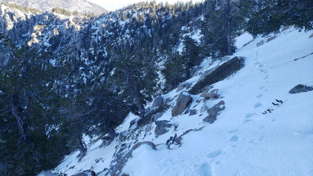
The only tracks known to be broken through the snow at this time are up Devil’s Slide Trail, onward via the PCT, Wellman and Peak trails to San Jacinto Peak, South Ridge (including on the north side of Tahquitz Peak [photo above]), and the PCT from Saddle south to Chinquapin Flat and north to Annie’s Junction.
Devil’s Slide Trail has been relatively well traveled (photo above) especially in its lower half.
We broke the length of South Ridge Trail on 9th January, including the north side of Tahquitz Peak. The trail south from Tahquitz Peak averages 6-8 inches of snow in the upper switchbacks (obscured by ice fall in places) decreasing to four inches at Old Lookout Flat (7600 ft). Below the Flat the trail is very sun-exposed, snow is only a couple of inches deep, and will clear quickly in warm and sunny days.
The 0.4 mile section of South Ridge Trail between Chinquapin Flat/PCT and Tahquitz Peak has a single posthole track to follow at this time through 12-30 inches of drifted powder (largely graupel). Spikes are not currently especially helpful due to the soft nature of the snow, but many hikers may consider using them (or even crampons) on this section. Hiking poles are useful.
No tracks were visible on 7th coming up via Deer Springs Trail, nor from Long Valley/Round Valley, either to Wellman Divide or via the Tamarack Valley to join the Peak Trail.
Carrying spikes is recommended everywhere above about 6000 ft at this time. This elevation will rise steadily over the next week or so due to melting especially in sun-exposed areas. Snow depths are now adequate for snowshoes above about 8000 ft. Possible further storms may change these recommendations.
SNOW DEPTHS measured on 7th January 2024 are as follows (or on 9th where indicated). Note that average depth is given; due to strong winds accompanying the storm on 7th, and the mobile nature of graupel, there has been considerable drifting, especially accumulating in trails. Altitudes and PCT mileages are approximate.
San Jacinto Peak (10810 ft): 9 inches (2 inches new snowfall on 7th January)
Wellman Divide (9700 ft): 7.5 inches (1.5 inches new snow on 7th, see photo above)
Annie’s Junction/approx. PCT Mile 181.8 (9070 ft): 8 inches (2 inches new snow on 7th), heavily drifted
Tahquitz Peak (8836 ft): 6-7 inches around the Peak itself [measured 9th January]
Saddle Junction/approx. PCT Mile 179.9 (8070 ft): 6 inches (1 inch new snow on 7th)
Old Lookout Flat (7600 ft on South Ridge Trail): 4 inches [measured on 9th January]
Devil’s Slide Trail at Humber Park (6550 ft): 4 inches (2 inches new snow on 7th)
Idyllwild (at 5550 ft): 2 inches, already partly melted by evening of 7th (1.5 inches new snow on 7th)

While all time and labor is volunteered, the San Jacinto Trail Report uses small private donations to help cover operating costs. Your contribution keeps the Report available to all, free from advertising or paywalls, and independent from agencies. If you have found this Report useful, please consider using this link to the Donate page. Thank you very much for your support.


Hi, I’m a PCT section hiker and last left the PCT by descending Devils Slide trail to Idyllwild. I have a question about returning to the PCT via Devils Slide vs. via the Wellman Divide Trail, which I understand one can access by riding up the Palm Springs Tram. I believe you’re familiar with that trail as well. Can you provide a comparison (mileage and elevation gain) via that route as compared to Devlis Slide (I’m familiar with the mileage/elevation gain for it)? If you can…at your convenience, no hurry! Thanks very much, Donna Park
LikeLike
Hi Donna, if you want to regain the PCT at Saddle Junction (where you left it) from the Tramway, you want the Willow Creek Trail. That is 5.0 miles and 800 ft of elev gain from Tram to Saddle. If for some reason you want to access Wellman Divide, which is not on the PCT but 1.3 miles from its nearest point, that would be 3.1 miles and 1200 ft via the Round Valley Trail from the Tram. For reference Devil’s Slide Trail is 2.5 miles long and 1550 ft of gain. Based on the maintenance quality of trail I would recommend using Devil’s Slide Trail (plus the Tram is expensive, and arguably sort of cheating!). Safe hiking, Jon.
LikeLike
Thanks so much for getting back to me so quickly, Jon – this is just the information I was looking for, much appreciated. I think that Devils Slide it will be (thought the elevation gain was greater than that, so good news there 🙂
Donna
LikeLike