UPDATE Wednesday 3rd January 2024: the minor storm this morning brought snow to all elevations above about 4500 ft, with two inches in Idyllwild (at 5550 ft) and four inches here at San Jacinto Peak. I hiked up through the storm and it snowed only for about three hours (0730-1030) but quite heavily at times, accumulating quickly on top of the existing 1-2 inches remaining from storms in late December.
I recorded a short video report from San Jacinto Peak at about 1300 this afternoon (linked here).

—————————
The San Jacinto mountains are now in or near part of the track of the prevailing jet stream (which averaged much further north throughout November-December) and consequently three storm systems are possible in the first two weeks of January 2024. A minor system on Wednesday 3rd is expected to be much colder than those earlier this winter, with a dusting of snow possible to 5000 ft (i.e., including Idyllwild), and 2-4 inches in the high country. The coldest system of this winter so far is forecast for 6th-7th January, with a snow level near or even below 4000 ft. However, in a dramatic late shift in the forecasts, that storm is now expected to bring much less snow than originally expected, with amounts probably similar to the system on 3rd. Finally another very cold and possibly significant snow storm is forecast for Thursday 11th January, with expected snow amounts perhaps greater than the two previous storms.
The ninth minor storm of this winter so far impacted the San Jacinto mountains on Saturday 30th December. It produced light rain and some hail in Idyllwild adding up to 0.35 inch. A dusting of snow across the high country included 0.25 inch of snow as low as Humber Park (6500 ft), one inch at Saddle Junction (8100 ft) and Wellman Divide (9700 ft) with 1.5 inches at San Jacinto Peak.
Trails are now generally clear of snow below 6700 ft elevation, and are clearing slowly on sun-exposed slopes up to 7500 ft, sometimes higher in places. However trails are becoming increasingly icy higher up as very thin snow is compacted by hiker traffic and following freeze-thaw cycles. Spikes are recommended everywhere above about 7000 ft at this time, although hikers experienced with icy snow travel may find them of limited use. Snow depths are insufficient for snowshoes or crampons even at the highest elevations. This advice may change soon with three snow-producing storms forecast over the next 10-12 days, much lower snow levels, and very cold temperatures.
Daily survey hikes in the San Jacinto mountains include various routes to San Jacinto Peak multiple times per week (most recently on 31st December and 2nd January), Tahquitz Peak and area at least once per week (most recently on 1st January), plus a wide variety of other trails on intervening days.
Water sources such as creeks, pipes, and springs largely continue to flow well for the time of year, thanks to the intensity of last winter plus various storms since August. So far they have not frozen in recent cold weather, however that may change next weekend given the expected temperatures and snowfall.
South Ridge Road (5S11) was graded on 15th October and reopened in mid November. May Valley Road (5S21) was fully graded in October, and is now much more user-friendly for both hikers and bikers. Dark Canyon Road (4S02) remains closed indefinitely, although the dirt section was partly graded in early October.
Black Mountain Road (4S01) was in its poorest condition for at least a decade by June this year. The partial grading undertaken in July improved the situation, but it remains a bumpy drive. Seasonal campgrounds and fire lookouts all closed for the winter by mid November.

WEATHER
Temperatures are forecast to be largely below seasonal at least into the second week of January 2024. Three cold storm systems are expected in the first half of January 2024. A minor system on Wednesday 3rd will be much colder than those so far this winter, with a dusting of snow possible to 5000 ft (i.e., including Idyllwild), and 2-4 inches in the high country. The coldest system of this winter so far is forecast for 7th January, with several inches of snow possible >10,000 ft elevation and a snow level near or even below 4000 ft. Finally another very cold and possibly significant snow-generating storm is tentatively forecast for Thursday 11th January, with expected snow amounts and elevational distribution expected to be greater than the previous two storms, but much uncertainty remains.
Air temperatures above 10,000 ft elevation are now typically in the 20s Fahrenheit (-6 to -2°C). For the first half of January, windchill temperatures at high elevations will generally be far below freezing, often well below 0°F (-18°C) on days during and immediately around storm systems. Such conditions require appropriate clothing and equipment for extremely cold conditions.
At San Jacinto Peak (3295m/10,810ft) on Tuesday 2nd January 2024 at 0910 the air temperature was 27.3°F (-3°C), with a windchill temperature of 16.7°F (-8°C), 28% relative humidity, and a fresh due West wind sustained at 6 mph gusting to 8.3 mph.
At the Peak on Sunday 31st December 2023 at 0915 the air temperature was 25.4°F (-4°C), with a windchill temperature of 13.3°F (-10°C), 17% relative humidity, and a light but cool due West wind sustained at 7 mph gusting to 10.6 mph.
At the Peak on Wednesday 27th December 2023 at 1015 the air temperature was 33.7°F (1°C), with a windchill temperature of 20.1°F (-7°C), 19% relative humidity, and a chilly WNW wind sustained at 10 mph gusting to 17.8 mph.

TRAIL CONDITIONS
There is continuous thin snow cover on almost all trails above about 7000 ft, with patchy icy snow sections as low as 6500 ft in places. Major trails largely have well-defined tracks through the snow at this time.
Even very thin snow has become icy in places on well-traveled trails due to freeze-thaw cycles and compaction by hiker traffic. Spikes are consequently recommended everywhere above about 7000 ft at this time. Snow depths are insufficient for snowshoes or crampons even at the highest elevations. Snow on sun-exposed slopes below 8000 ft is very thin but is unlikely to melt in the next couple of days.
Deer Springs Trail below Strawberry Junction (8100 ft) is partly clear of snow. From Strawberry Junction to San Jacinto Peak the snow cover is continuous. Spikes are useful, especially for descending the upper trail.
Marion Mountain Trail is largely covered with thin icy snow, with only the lowest 0.5 mile clear of snow. Snow is 0.5 inch deep lower down, increasing to two inches high up. Spikes are useful for descending the upper trail especially.
Devil’s Slide Trail is already largely clear of snow to 7000 ft. Thin snow cover is largely continuous on the middle and upper trail and is becoming very icy. Spikes are useful, especially for descending.
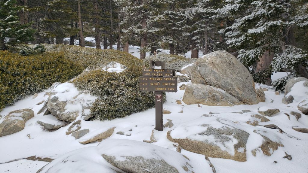
The Wellman and Peak trails, although both largely open and sun-exposed, currently remain snow-covered. A well-traveled track comes up to Wellman Divide from Long and Round valleys, with continuous snow above Round Valley at least.
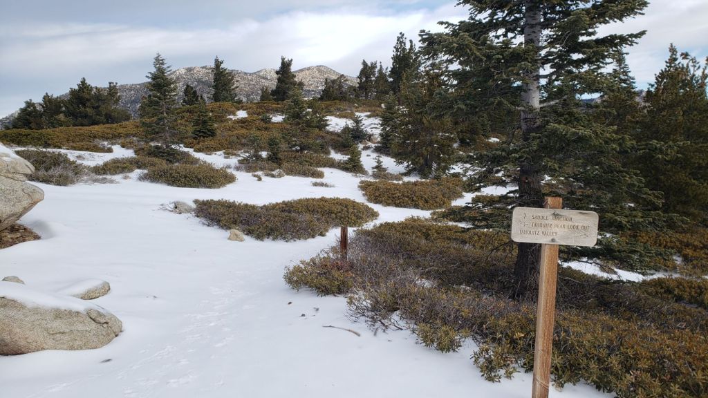
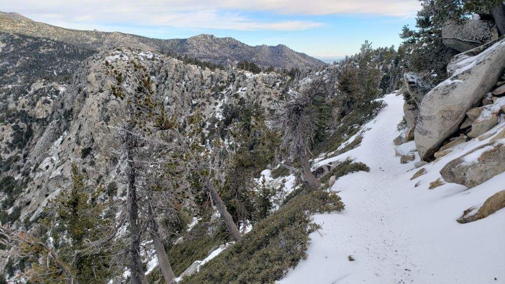
Trails on the north side of Tahquitz (photo below) and Red Tahquitz peaks, including PCT Miles 175.5-177.5, and around the Tahquitz area meadows, remain fully covered with thin snow. Snow is at its deepest on the north side of Tahquitz Peak (2-4 inches deep) but the trail is neither icy nor angled by drifting. South Ridge Trail south from Tahquitz Peak is almost completely snow-covered down to Old Lookout Flat at 7600 ft (surveyed 1st January) but the snow is very thin and not too icy (spikes are recommended for descending the upper switchbacks at least). The trail is functionally clear of snow below 7600 ft.
Fuller Ridge Trail has continuous snow cover (surveyed 27th December), although nowhere is the snow depth greater than about three inches in the trail. The most sun-exposed sections of the trail are partially clearing of snow.
Tropical Storm Hilary in late August resulted in one or two new treefall hazards on most trails, but only Willow Creek and Fuller Ridge trails were more significantly impacted.
Please see the Trail Conditions section of the previous Report (linked here) for details of the current status of treefall hazards and obstructions on the following trails: Willow Creek Trail, Fuller Ridge Trail, Deer Springs Trail, Skunk Cabbage and Tahquitz area meadows, South Ridge Trail, Marion Mountain Trail, Spitler Peak Trail, Caramba Trail, and Seven Pines Trail.
Elsewhere on the PCT treefall hazards remain a problem in many places, most notably between Apache Peak and Red Tahquitz, where I counted at least 106 between Miles 169-175 in late 2023. Large downed trees make for especially slow-going around Miles 172-175 (a section severely impacted by the July 2013 Mountain Fire).
SNOW DEPTHS measured on 31st December 2023 are as follows. Note that average depth is given; due to strong winds accompanying storms there has been drifting, often accumulating in the trails. Altitudes and PCT mileages are approximate.
San Jacinto Peak (10810 ft): 2-3 inches (1.5 inches fresh snowfall on 30th December 2023)
Little Round Valley (9750 ft): 3 inches, drifted deeper in places
Wellman Divide (9700 ft): 1.5 inches (1 inch new snow on 30th December)
Annie’s Junction/approx. PCT Mile 181.8 (9070 ft): 2 inches (1.5 inches fresh snowfall on 30th December 2023)
Tahquitz Peak (north side trail, 8700 ft): 2-4 inches, drifted deeper in places [measured 1st January 2024]
Tahquitz Peak (south side trail, 8500-8700 ft): 0.5-1 inch [measured 1st January 2024]
Long Valley (8600 ft): 0.5 inch on 31st December 2023
Saddle Junction/approx. PCT Mile 179.9 (8070 ft): 1.5 inches (1 inch new snow on 30th December)
Devil’s Slide Trail at Humber Park (6550 ft): patchy 0.5 inch on 31st December, already melted
Idyllwild (at 5550 ft): 0 inch

While all time and labor is volunteered, the San Jacinto Trail Report uses small private donations to help cover operating costs. Your contribution keeps the Report available to all, free from advertising or paywalls, and independent from agencies. If you have found this Report useful, please consider using this link to the Donate page. Thank you very much for your support.