UPDATE Saturday 11th March: It started raining yesterday morning at about 0700 at mid elevations, with a mixture of rain and light sleet in Long Valley (8600 ft) from about 1100. Rainfall in Idyllwild totaled an impressive 2.36 inches (measured at 5550 ft), finally stopping at 0930. Snow level in the high country is estimated to be at about 9500 ft, with none falling in Long Valley and only a couple of inches expected around the highest peaks.
UPDATE Thursday 9th March: I snowshoed this morning to San Jacinto Peak via Devil’s Slide Trail and the eastern side route. With freeze/thaw cycles, Devil’s Slide was firm early morning, and I ascended to Saddle Junction just in spikes. I then used snowshoes from there to the Peak, and all the way back down. My track from last week had held up well, and my ascent was consequently nearly two hours faster. By late morning the snow was getting soft and sloppy, and postholing would have been brutal. Snow melt/compaction has been rapid and substantial in just a week, 6-12 inches at all high country locations I measured (and even more in Idyllwild). Snow conditions are generally benign, excellent for snowshoeing, there is no avalanche risk (now even on the north face), and the continued State Park closure seems insupportable.
UPDATE Wednesday 8th March: Light but steady rain is now forecast at mid elevations for at least 10th-11th and 14th-15th March, with about one inch inch expected at mid elevations during the first of these storms, and roughly half that amount during the second storm. Combined with mild temperatures, the rain on snow will further increase melting, and make for very sloppy snow conditions. The high country may be above the cloud for some of the storm days, but light snow is tentatively forecast at higher elevations, especially on 14th-15th.
UPDATE Monday 6th March: Idyllwild had a very light dusting of snow (0.1 inch) early this morning, and it was drizzling in Garner Valley. Fobes Ranch Road (the side access to the PCT from about Mile 165) is clear of snow. Snow depth has more than halved in the past few days at PCT Mile 151 where the trail crosses Highway 74 (now averaging 4-6 inches with some bare patches, photo below). Given the strong warming trend in the next week, by the time the Forest closure is expected to lift on 16th March the PCT will be readily passable from Mile 151-165 (spikes strongly recommended). Proceeding north from Mile 165 is not currently recommended, as it will require crampons, ice axe, and the necessary snow hiking experience to use that equipment safely in high angle terrain, plus considerable patience, stamina, and route-finding skills.
————————
Well that was fun! Five snow storms impacted the San Jacinto mountains in a nine day period, ending 1st March. All the storms were somewhat different from one another in terms of quantity of snowfall, associated temperatures and winds, and lowest snow elevation. Strawberry Valley (where Idyllwild is located) was hit hardest relative to its elevation, with heavy snow there even at times that the high country was above the cloud, as reflected in the snow totals below.
I won’t repeat all the details as these storms were largely summarized in a daily updated blog format maintained over the past week or so (available here). Their combined impact was dramatic, including just over a foot of snow throughout Garner Valley (4300-4800 ft), nearly four feet of snow in Idyllwild (the annual average for town is 31 inches), and 2.5-4 feet of snow in the high country, depending on elevation.
The snowfall in Idyllwild this winter has already been the most recorded for 59 years, as discussed in a summary of National Weather Service statistics that I posted on 2nd March (linked here). With another 5-6 inches, we could experience the most snow to fall in Idyllwild in one winter since the 1940s.
Regrettably one consequence of this impressive snowfall is closure of both the National Forest lands and State Park wilderness in recent days. The latter is particularly unfortunate as conditions are actually more benign now than they were 2-6 weeks ago, when high country slopes were extremely icy and required more specialist equipment and skills.
San Bernardino National Forest, including the San Jacinto Ranger District, is closed until at least 16th March 2023. See their closure notice here for more details. The State Park wilderness closed on 1st March (see State Park website). It is clear that these closures will dramatically and negatively impact early season PCT hikers.
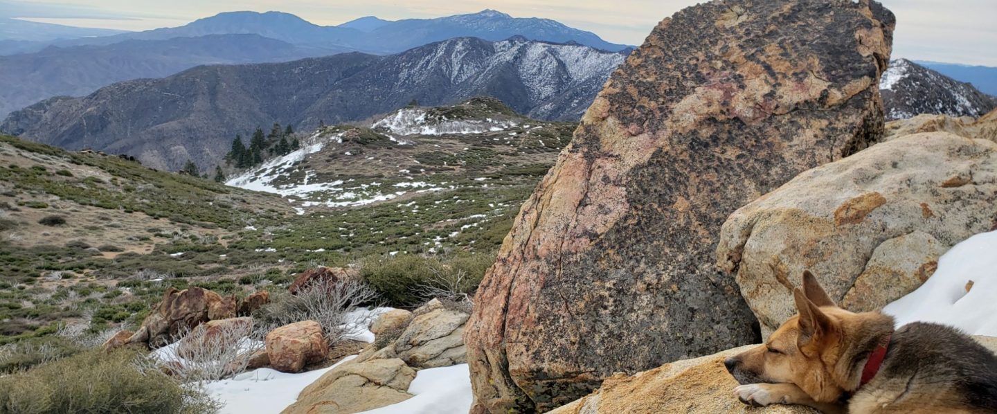
On Friday 3rd March I ascended and descended San Jacinto Peak via the east side (roughly the Devil’s Slide, Wellman, Peak, and East Ridge trail routes), breaking trail snowshoeing the entire way from Humber Park. I recorded a lengthy video discussing the general snow and closure situation while at the Peak (available here) plus a brief panorama video from the Peak itself (available here).
Currently trails above about 5500 ft (lower in places) are largely obscured by moderate to deep snow. Trails down to 4000 ft elevation currently have shallower snow cover. Very cautious navigation is essential everywhere.
Details of snow depths measured at various locations on the trail system are given at the foot of this posting. Note that snow depth itself is rarely indicative of the difficulty (or otherwise) of hiking a particular track or trail. For example a well-compacted snowshoe track across snow several feet deep may be much easier hiking than an angled icy section just a few inches deep.
Conditions are currently ideal for snowshoes everywhere (that is open) above about 4500 ft. This elevation will climb steadily over the next few days as temperatures rise and melting accelerates.
Crampons – with hiking poles and an ice axe, depending on terrain – may become increasingly useful everywhere above about 6500 ft, as freeze/thaw cycles lead to hardening of the snow surfaces. They will likely become essential on certain moderate and higher angle slopes, at a minimum on the Peak Trail above Wellman Divide, the Wellman Trail, Deer Springs Trail above Little Round Valley, and uppermost South Ridge Trail, and on both flanks but critically on the north face of Tahquitz Peak.
Currently, and increasingly as snow conditions change, spikes are strongly recommended for the foreseeable future everywhere above about 4000 ft. They are currently invaluable even for walking around Idyllwild early in the morning! This elevation will slowly move upwards with steady melting over the next few days and weeks, but will remain relatively low for weeks at least.
Recently I have mentioned the challenges of hard, icy snow underfoot and the value of using spikes (and/or crampons) especially for descending and traversing. While fresh snow may be optimum for snowshoeing for the next several weeks, snow at all elevations will become increasingly firm and icy following multiple freeze-thaw cycles, and compaction by increasing hiker traffic in places (once trails reopen), and I cannot overemphasize the importance of having both appropriate equipment and the right skill set for the terrain. The latter includes interpreting the snow/ice conditions, understanding your physical and mental abilities, and conservative decision making. These concerns will steadily increase over the next few weeks with temperatures fluctuating either side of freezing, seasonally stronger insolation, and highly variable snowmelt.
Hikers should be prepared for temperatures below freezing in the high country (once generally accessible), and well below freezing when considering wind chill effects.
The USFS gate at Humber Park is closed. Even when the gate is closed there are nine legal parking spaces below the locked gate (which still require an Adventure Pass or equivalent to be displayed). If there are “Road Closed” signs across Fern Valley Road near its junction with Forest Drive – currently the case due to the forest-wide closure – then those nine spaces are also unavailable for legal parking.
Based on my assessment on 3rd March, there is currently no significant avalanche risk (other than on the north face of San Jacinto Peak, which, contrary to recent erroneous information in local media, avalanches regularly every year, even in low snow years). Snow layers evidently consolidated rapidly, and the situation will only improve further with melting and freeze/thaw cycles. I found none of the pre-avalanche characteristics that I last observed on the exposed easterly slopes above 10,000 ft in early 2017 (in shallower but more dangerously layered snow).

WEATHER
After the meteorological excitement of the past two months, even a few days of relatively sunny, dry weather seem notable. A steady warming trend will lead to temperatures above seasonal (remember those?) from Friday 10th March onwards, rapidly accelerating snowmelt. Many of the next ten days will be at least partly cloudy. Temperatures in the high country will remain at or below freezing for another few days, before moving just above freezing starting Thursday 9th.
Light but steady rain is now forecast at mid elevations for at least 10th-11th and 14th-15th March, with about 1.0 inch expected at mid elevations during the first of these storms, and roughly half that amount during the second storm. Combined with mild temperatures, the rain on snow will further increase melting, and make for very sloppy snow conditions. The high country may be above the cloud for some of the storm days, but light snow is tentatively forecast at higher elevations, especially on 14th-15th.
The latest NWS San Diego video forecast (available here) provides an excellent summary of what happened meteorologically throughout the California mountains in late February, plus an overview of the weather coming to Southern California in March.
At San Jacinto Peak (10,810ft/3295m) on Friday 3rd March 2023 at 1155 the air temperature was 27.9°F (-2°C), with a windchill temperature of 10.1°F (-12°C), 18% relative humidity, and a frigid NW wind sustained at 14 mph gusting to 25 mph.

TRAIL CONDITIONS
All trails above about 4000 ft are largely snow-covered (wholly snow-covered above about 5000 ft). This will change steadily with melting over the next few days and weeks.
Devil’s Slide Trail [updated 9th March] has a lightly-traveled snowshoe and posthole track up to Saddle Junction. It is firm in cold early mornings (ideal for spikes) but soft and sloppy by late morning (snowshoes required, or expect deep postholing). The track does not follow the established trail route in the uppermost switchbacks close to Saddle Junction, and very careful navigation is required.
My snowshoe track continues on to San Jacinto Peak, via a route roughly approximating to the PCT, Wellman, Peak, and East Ridge trails, climbing more steeply in places than the established trails, and generally contouring through the snow as needed to minimize unnecessary elevation loss. Dustings of snow forecast over the next week or so may combine with strong winds to obscure parts of this track.
The Ernie Maxwell Trail [updated 8th March] has a very lightly traveled snowshoe and posthole track to follow along its entire length. Early morning the snow is firm and relatively easy to hike, but it will be soft with deep postholing by late morning. The majority of this trail is not on Forest Service land.
In addition to the wider closure mentioned above, effective 26th January 2023 the State Park closed the section of Skyline Trail that falls within its jurisdiction, above 5800 ft elevation, “until further notice due to dangerous weather conditions”. (For readers who are unclear, Skyline Trail forms the lower two-thirds of the “Cactus-to-Clouds” [C2C] route.) The State Park boundary is not marked but is near the site of the old Florian’s Cache, below Flat Rock. The open section of trail below 5800 ft received some light snow cover down to about 4500 ft over the past week, but this has already melted.

SNOW DEPTHS
Measured on Friday 3rd March (unless otherwise stated). The first number is the current total snow depth, with the fresh snowfall in the multi-storm event from 21st February to 1st March given in parentheses. Note that averages are given; due to strong winds accompanying all storms this winter there is widespread drifting. Altitudes are approximate.
San Jacinto Peak (10810 ft): 80-85 inches (40-45 inches)
Wellman Divide (9700 ft): 70-75 inches (30-35 inches)
Annie’s Junction/PCT Mile 180.8 (9070 ft): 75-80 inches (30-35 inches), heavily drifted here
Long Valley (8600 ft): 55-60 inches (35-38 inches)
Saddle Junction/PCT Mile 179 (8070 ft): 48-50 inches (28-30 inches)
Devil’s Slide trailhead at Humber Park (6550 ft): 46 inches on 2nd March (44-46 inches) melting rapidly by 3rd
Idyllwild (at 5550 ft): 45-46 inches on 2nd March (45-46 inches) melting rapidly by 3rd
PCT Mile 151 at crossing with Highway 74 (4800 ft): 13 inches, measured on 27th February

While many hundreds of hours of time and labor are volunteered annually, the San Jacinto Trail Report uses small private donations to help cover modest operating costs. Every year seems to have its unique challenges, and clearly 2023 will be no exception. Your contribution keeps the Report available to all, free from advertising or paywalls, and independent from agencies. If you have found this Report useful, please consider using this link to the Donate page. Zelle, Venmo, and PayPal are all options. Thank you so much for your support.


