UPDATE Sunday 1st January 2023: A moderate overnight storm produced 1.53 inches of rain in Idyllwild (at 5550ft). Snowfall in the high country has been somewhat below expectations, with nine inches at San Jacinto Peak (for a current total depth of about 16-18 inches), and 5-6 inches in Long Valley (8600ft, total c.6 inches). However a couple more inches of snow are expected this afternoon, and also on 2nd and 5th January.
UPDATE Thursday 29th December: I have uploaded a video from my hike to San Jacinto Peak this morning (available here on YouTube) where I enjoyed a minor snow storm. Compacted trails – such as Devil’s Slide, Deer Springs, Marion Mountain, South Ridge – are extremely icy between 7400-8900 ft due to the rain yesterday which has now frozen. Spikes are strongly recommended. Between the dustings of snow yesterday and today, high country tracks are becoming obscured and cautious navigation is strongly advised. The forecasts are very unsettled for the next week, but significant snowfall arrives on Saturday 31st (12+ inches expected in the high country) and may continue on/off until Friday 6th January 2023, potentially totaling 2-3 feet above 10,000 ft elevation.
UPDATE Wednesday 28th December: the overnight rain storm produced 0.73 inch in Idyllwild (measured at 5550 ft) while Long Valley (8600 ft) led San Jacinto mountain locations in rainfall with 1.01 inch. Due to the very high freeze level snowfall was restricted to a light dusting above 8200 ft, increasing to one inch above 9000 ft and 1.5 inch above 10,000 ft. Impacts will be minimal on high country trails, but trails between 7000-9000 ft with pre-existing snow may be a mix of slush, snow and ice, and will require some caution.
—————————————-
The holiday weekend had temperatures far above seasonal until Tuesday 27th. Such unseasonably warm temperatures led to rapid snow melt everywhere, despite the low sun angle at this time of year, while in many areas freeze/thaw cycles have resulted in icy trails and roads especially in the early mornings.
Such warm conditions will soon be a distant memory. Multiple “atmospheric river” storm systems are forecast to bring very unsettled weather to the San Jacinto mountains starting Tuesday 27th December, lasting well into the first week of January. While these are expected to bring significant precipitation throughout the state, there remains considerable uncertainty regarding timing and precipitation amounts for Southern California.
A key feature of this sequence of storms will be the relative warmth of the air masses which will lead to high freeze levels. This may mean rain and/or freezing rain as high as 10,000 ft, and challenging layers of icy or mixed snow/ice conditions at all elevations, including the possible melting of some or most preexisting snow below about 8000 ft due to rainfall.
Current forecasts for precipitation suggest as much as three inches of rain around the elevation of Idyllwild (5000-6000 ft) between the evening of Tuesday 27th December 2022 and Friday 6th January 2023. Forecasts for snowfall have varied greatly in both timing and volume, the latter ranging from inches to feet.
The first storm system comes through overnight on Tuesday 27th, with precipitation continuing into the morning of Wednesday 28th. Up to one inch of rain is forecast at mid elevations, but with only a couple of inches of snow likely around the highest peaks as the high country may be above the cloud for some of the storm. The freeze level will initially be above 10,000 ft, ultimately only falling to about 9000 ft, so many of the main access trails to the high country may get no new snowfall.
The second system may be more substantial, with precipitation expected most of the day and night of Saturday 31st December into Sunday 1st January. The freeze level will again start very high, but is forecast to fall lower, with the possibility of a light dusting of snow down to about 5500 ft. Another inch of rain is forecast for mid elevations, but a heavier snowfall is expected in the high country, with predictions ranging from 8-20 inches above 10,000 ft.
Further precipitation is tentatively forecast for 3rd-6th January, but amounts, timing, and freeze levels remain uncertain this far ahead. Again the freeze levels may be relatively high, with little more than an inch or two of snow likely below 6000 ft, a forecast 2-6 inches of fresh snowfall in the high country scattered across two or more days, and roughly 0.5-1.0 inch of rain (perhaps mainly freezing rain) throughout the mid elevations.
Recent hikes have included the high peaks (>10,000 ft) 2-4 times per week by various routes, Tahquitz Peak and area 1-2 times per week, South Ridge, Spitler Peak, and Marion Mountain trails, and May Valley Road and Indian Mountain Truck Trail.
Early morning hikes to San Jacinto Peak have generally had icy snow underfoot with sufficient bite for grippy boots, allowing me to bareboot all the way to San Jacinto Peak. There I generally put on Kahtoola microspikes for the descent. On 22nd for example I wore spikes down to about 7500 ft on Marion Mountain Trail, while on 27th I wore spikes down the Peak and Wellman trails and PCT down to 9000 ft.
Although good tracks are now in place for most major trails (details below), cautious navigation is recommended everywhere. Snow expected in the high country in the early hours of Wednesday 28th is not expected to be sufficient to obscure some of the higher elevation trails and complicate navigation.
Snow depths measured at various locations on the trail system are given at the foot of this posting. Note however that snow depth itself is rarely indicative of the difficulty (or otherwise) of hiking a particular trail. Very shallow snow is often icy and potentially perilous, while deeper powder can actually be much safer, albeit slow-going for hiking. Snow depths are expected to change multiple times over the next ten days due to mixed precipitation, including even possibly loss of snow at mid elevations due to rainfall.
Spikes are currently recommended throughout the trail system above about 7500 ft. They are not however required, depending upon your comfort level hiking on shallow variable snow, potentially mixed with slushy and/or icy patches (depending upon time of day). Spikes are expected to remain extremely useful over the next few weeks given the unpredictable weather. They tend to be especially valuable for descending trails.
Snowshoes are currently not required on the established trail system, which is now too heavily traveled and compacted for snowshoes. However they remain valuable for off-trail travel at elevations above about 9000 ft (potentially lower in places). Snowshoes are likely to become useful (even essential in early January), at least above about 9000 ft, if there is significant snowfall during the coming week or so as forecast.
Hikers should be prepared for temperatures below freezing in the high country, and generally far freezing when considering wind chill effects.
The USFS gate at Humber Park remains closed. Even when the gate is closed there are nine legal parking spaces this side of the locked gate (near the upper Ernie Maxwell trailhead; these nine space still require an Adventure Pass or equivalent). Vehicles not parked in these spaces have been ticketed and/or towed. If there are “Road Closed” signs further down – as was often the case last winter especially at weekends and holiday periods after fresh snowfall – then those nine spaces are also unavailable for legal parking.
South Ridge Road (5S11) remains closed to vehicle traffic. On 24th the road had about 30% patchy ice cover.
Dark Canyon Road (4S02, the access to Seven Pines Trail) and Santa Rosa Truck Trail (7S02) closed to vehicle traffic for the season on 7th November 2022. Black Mountain Road also closed on 7th November to vehicle traffic at the gate 1.7 miles up from Highway 243. Forest Service campgrounds at Boulder Basin, Marion Mountain, and Fern Basin, and the State Park campground at Stone Creek, are closed for the season.

WEATHER
The strange rollercoaster ride that has been winter 2022/23 so far will continue for the foreseeable future. Multiple mild storm systems are forecast to bring extremely unsettled weather to the San Jacinto mountains starting Tuesday 27th December, lasting well into the first week of January. Latest details are given in the introduction above. Rainfall may continue at mid elevations potentially for several consecutive days, and the relative warmth of the air masses may produce rain and/or freezing rain as high as San Jacinto Peak, challenging layers of icy or mixed snow/ice conditions at all elevations, and perhaps melting of much preexisting snow below about 8000 ft.
Current forecasts for precipitation suggest as much as three inches of rain around the elevation of Idyllwild (5000-6000 ft) between the afternoon of Tuesday 27th December 2022 and Wednesday 4th January 2023. Regarding snowfall, the high country may be above the cloud at times, with dustings of snow above about 7000 ft across much of the nine day period, but with the highest probability for a heavy snowfall on Saturday 31st December, totaling 8-15 inches.
At San Jacinto Peak (10,810ft/3295m) on Tuesday 27th December 2022 at 0850 the air temperature was 31.2°F (-1°C), with a windchill temperature of 15.1°F (-9°C), 31% relative humidity, and a sharp WSW wind sustained at 17 mph gusting to 26.1 mph.
At the Peak on Thursday 22nd December 2022 at 0910 the air temperature was 39.9°F (4°C), with a windchill temperature of 30.4°F (-1°C), 13% relative humidity, and a light WNW wind sustained at 9 mph gusting to 13.8 mph.
At the Peak on Monday 19th December 2022 at 0920 the air temperature was 31.3°F (0°C), with a windchill temperature of 20.7°F (-6°C), 9% relative humidity, and a gentle WNW wind sustained at 5 mph gusting to 9.9 mph.

TRAIL CONDITIONS
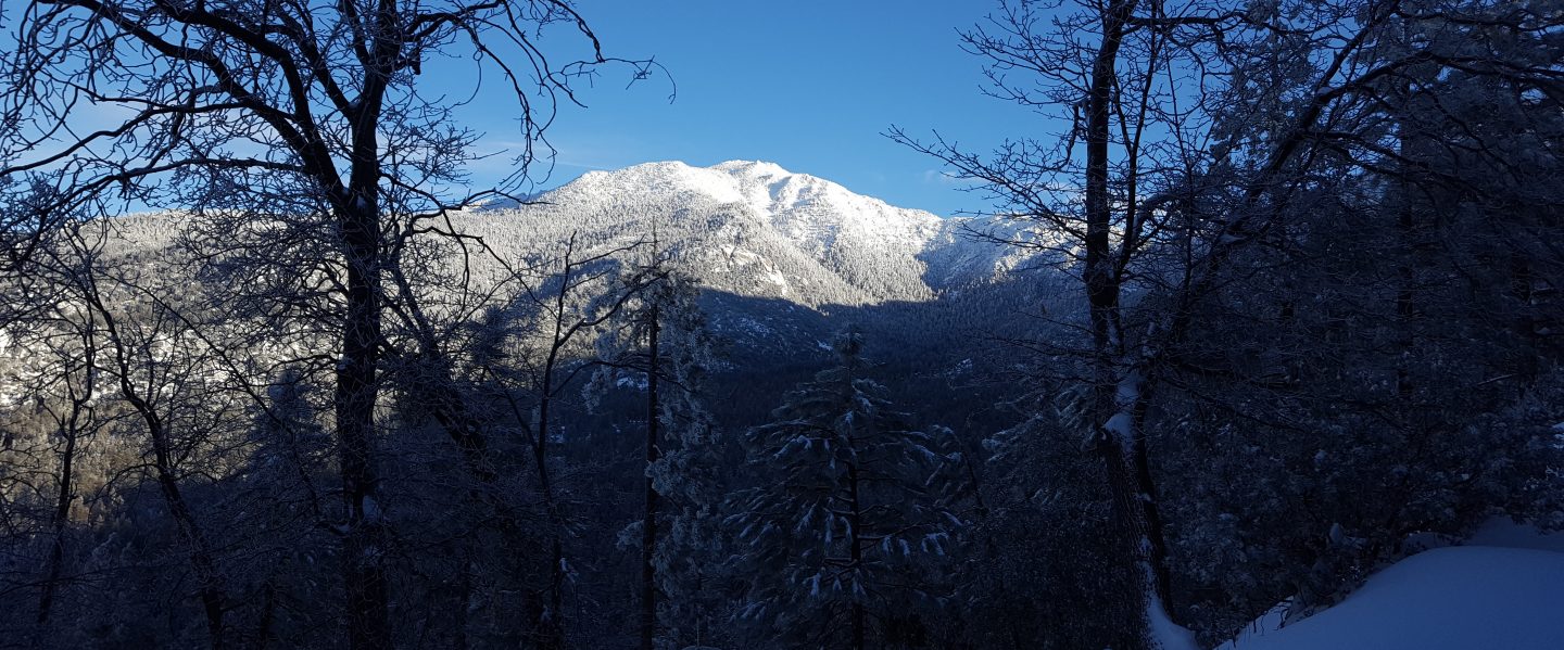
All trails above about 7500 ft remain lightly snow-covered. However, relatively well-traveled tracks are now in place for most major trails (details below). These conditions are expected to change significantly over the next ten days due to the highly unsettled weather forecast into early January.
The Ernie Maxwell Scenic Trail is largely clear of icy snow, with a few patches remaining, mostly close to Humber Park.
Devil’s Slide Trail is functionally clear of snow below 7600 ft, about two miles up, and then snow cover is about 60% up to Saddle Junction but becoming almost continuous within 0.2 mile of the junction. Spikes are recommended.
The 0.4 mile section of South Ridge Trail between Chinquapin Flat/PCT and Tahquitz Peak has a lightly traveled posthole track to follow through the drifted powder. Although not essential in the moderate depth powder, spikes are strongly recommended and many hikers will find them useful especially for descending. Hikers who have an ice axe (and know how to use it) may find it useful in places on this short section of trail. This trail will become significantly more treacherous as it is expected to add freezing rain and/or layers of snow and ice over the next ten days.
For about one mile north of Saddle Junction, snow cover is only a patchy 30% on the sun exposed slope (“Angel’s Glide”) and then averages about 50% on the Wellman Trail, but then icy snow cover is about 95% on the Peak Trail to San Jacinto Peak. However the route is now well-traveled and compacted.
There is a lightly traveled compacted snowshoe track on the East Ridge between Miller Peak and San Jacinto Peak but it does not accurately follow the route of the East Ridge Trail.
There is a compacted, well-traveled track on continuous light icy snow from Long Valley/Tram to Wellman Divide.
Skyline Trail has a good track to follow through very thin and patchy icy snow above about 7200 ft (the Traverse to Grubb’s Notch). Some hikers will find spikes preferable.
South Ridge Trail [updated 24th December] has about 30% icy snow cover from the top of South Ridge Road to Old Lookout Flat (7600 ft). To Tahquitz Peak snow cover averages about 40%, alternating on the 18 switchbacks between those that are largely clear (south-facing) and those that are largely snow-covered (north-facing). There is a well-traveled track to follow through the very light and patchy 1-3 inches of icy snow. Spikes are not generally required for ascending, but most hikers will find them useful for descending.
Deer Springs Trail [updated 22nd December] has an accurate track to follow all the way to San Jacinto Peak as I broke trail the entire way down to the Suicide Rock Trail junction on 15th December. I was pleased to see that over the weekend some posthole tracks were added on top of my snowshoe track from last week all the way up Deer Springs Trail to San Jacinto Peak. Although my original track accurately followed the trail above Little Round Valley, there are now a fair number of alternate shortcut tracks across this slope, so cautious navigation is advised. The trail is largely clear of snow from Highway 243 to Strawberry Junction, and with about 60% snow cover from there up to 8600 ft.
Marion Mountain Trail [updated 22nd December] has a well-defined but lumpy posthole track throughout. Spikes are recommended, at least for descending. A few cleared patches are developing below 7000 ft.
Seven Pines Trail has not been traveled since the storm in mid December, at least not in its uppermost section, and there is no track to follow through the snow.
Spitler Peak Trail is now functionally clear of snow. There is a very visible boot track – through light snow in places in its upper switchbacks – to the PCT.
SNOW DEPTHS measured on 22nd-27th December 2022 are as follows. The first number is the current total snow depth, followed in parentheses by the greatest depth of the winter to date following the latest storm on 11th-12th December. Note that average depth is given; due to strong winds accompanying the storm there is extensive drifting, often particularly accumulating in the trails. Conversely in some places scouring by the wind means the depths are well below the average. Altitudes are approximate.
San Jacinto Peak (10810 ft): 6-8 inches (12-14 inches on 12th December)
Little Round Valley (9800 ft): 8 inches (10-12 inches on 12th December)
Wellman Divide (9700 ft): 0-2 inches (7 inches on 12th December)
Annie’s Junction/approx. PCT Mile 181.8 (9070 ft): 2-3 inches (5.5 inches on 12th December)
Marion Mountain Trail at junction with PCT (8700 ft): 3-4 inches (6 inches on 12th December)
Long Valley (8600 ft): 1-2 inches (5-6 inches on 12th December)
Strawberry Junction (8100 ft): 0-1 inches (4 inches on 12th December)
Saddle Junction/approx. PCT Mile 179.9 (8070 ft): 0-1 inch (4 inches on 12th December)
Devil’s Slide trailhead at Humber Park (6550 ft): 0 inch (3.5 inches on 12th December)
Idyllwild (at 5550 ft): 0 inch (3.0 inches on 12th December).
Thank you for taking the time to read this. While all time and labor is volunteered, the San Jacinto Trail Report uses small private donations to cover costs. Every year seems to have its unique challenges and 2022 has been no exception. Your contribution keeps the Report available to all, free from advertising or paywalls, and independent from agencies. If you have found this Report useful, please consider using this link to the Donate page. Zelle, Venmo, and PayPal are all options. Thank you so much for your support.


Hey, Merry Christmas to you and your family, Jon! TY for your reports. I hope we don’t get too much warm rain in the high country with this next storm system. Jeri John jerijohn@verizon.net
LikeLike
Thank you Jeri, likewise to you and yours. It is a bit of a mystery what we might get over the next ten days, the forecasters are having a hard enough time and our mountains have a habit of making their own weather, as we know.
LikeLike