
[UPDATED Wednesday 7th September @ 1630: news from the Fairview Fire has not been good this afternoon. Dramatic fire activity up (and out of) Bautista Canyon has continued and latest size estimate is now 9845 acres. The fire has apparently crossed Rouse Hill Road (5S15) near its northern end putting it less than one mile from Highway 74 (roughly a couple of miles east of Cranston).]
[UPDATED Wednesday 7th September @ 1430: latest reports indicate the Fairview Fire continues steady progress south-east up both sides of Bautista Canyon. Total size now at least 7100 acres. Crews have been placed at Bautista Conservation Camp for structure defense. An intensive Phos-Chek campaign is underway to protect the antennas and fire lookout at Red Mountain.]
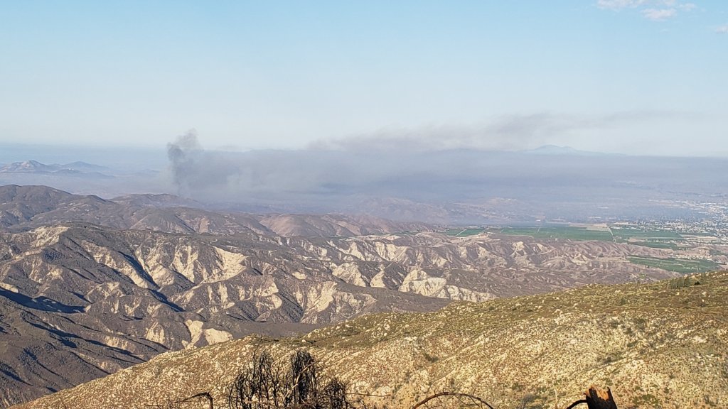
[UPDATED Wednesday 7th September @ 0530: early this morning the Fairview Fire was estimated at 6520 acres, having more than doubled in size in the past 24 hours. Almost all of the spread was east into northern Bautista Canyon. The good news for residents of Idyllwild and Mountain Center is that winds today are expected to be weaker and variable but largely easterly, hopefully holding the fire well to our west in the Bautista Canyon area. Thanks to Hurricane Kay, cooler, damp, cloudy conditions are forecast for 9th and 10th September.]
[UPDATED Tuesday 6th September @ 2030: the Fairview Fire, now well over 5000 acres, is expanding steadily along a broad front, mainly to the southeast, occupying much of northern Bautista Canyon. A huge expanse of flame was visible to the naked eye about eight miles west of town this evening from Idyllwild.]
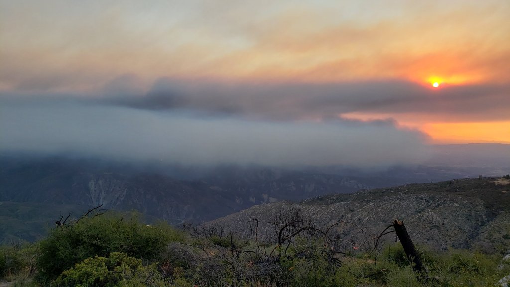
[UPDATED Tuesday 6th September @ 1650: the Fairview Fire is now estimated at 4500 acres. It continues to push east, having crossed into the National Forest and jumped Bautista Canyon Road. At that point the fire hits very rugged terrain with a lot of unburned fuel and it will be challenging to slow its progress. A combination of evacuation order and evacuation warning was recently issued for a huge area south and west of Highway 74 and north of Highway 371, roughly Mountain Center to Thomas Mountain and south to Anza.]
Attention is currently on the Fairview Fire which started just south-east of Hemet late afternoon on 5th September, quickly spreading to over 2000 acres, killing two people and destroying multiple properties. Although early this morning the eastern flank of the fire was about ten miles west of Mountain Center, and just over one mile west of the National Forest boundary, we know from recent experience (notably the Cranston Fire in July 2018) that fires can cover the ground from the east end of Hemet to the fringes of Idyllwild in a few hours. Thankfully the wind direction and wind speed currently make that scenario unlikely.
The exceptional heatwave that has been impacting our region since the end of August continues for another couple of days. The heatwave is forecast to break quite dramatically on Friday 9th, when the San Jacinto mountains will catch the edge of Hurricane Kay as it churns off the northwest coast of Baja California. Gale force winds around the highest peaks on Friday 9th will result in windchill temperatures below freezing on 9th-10th September in the high country even though air temperatures may be near 50°F (10°C). How much precipitation is associated with the wind and cloud is unclear from the divergent forecast models, currently ranging from a light drizzle to a couple of inches, but about 0.5-1.0 inch is suggested by most forecasts, mainly overnight on Friday 9th into the morning of Saturday 10th.
Water conditions where known are detailed at the foot of this Report. Please note these may change rapidly if there is substantial precipitation on 9th-10th September. Hikes have included thorough surveys of water resources on the major trail systems on both the western and eastern slopes of the San Jacinto high country frequently, plus Round Valley and the Tahquitz area meadows. Current conditions for individual trails are discussed in detail below where known.
Hikers should continue to be prepared for exceptionally hot weather until Friday 9th September, with overnight “low” temperatures at least 15-20°F above seasonal and daytime high temperatures around 90°F (32°C) even at 6000 ft elevation. Plan accordingly regarding route choice, start time, clothing, sun protection, and water requirements.
Hikers should be prepared for unpredictable, rapidly changing weather conditions in the high country in late summer. Monsoonal storms, typically in the afternoon, remain a possibility throughout September (in addition to the possible tropical storm spinoff on 9th-10th). Thunderstorms with lightning, brief but intense precipitation, and rapid temperature drops, can occur in the high country even when such storms are not forecast for lower elevations.
All hikers, but especially those planning to hike Skyline Trail (either on its own or as part of the “Cactus-to-Clouds”), should note that the Palm Springs Aerial Tramway is closed for annual maintenance from Monday 12th September to Sunday 9th October 2022, with a tentative reopening date of 10th October.
Full fire restrictions were introduced on Thursday 26th May on Forest Service lands, as described in detail here. Campfires on all USFS lands in the San Jacinto mountains (including in fire rings at campgrounds and yellow post sites), and smoking, are prohibited for the remainder of the year. Fires are never permitted in the State Park wilderness.
Dark Canyon Campground will not reopen this year due to staffing/maintenance issues.
May Valley Road (5S21) remains closed, including to foot traffic. Work to remove hazardous trees, burned by the 2018 Cranston Fire, finally got underway in mid August. The current closure order expired on 5th September, but work looks unlikely to be completed until later this month.
WEATHER
Temperatures that have been far above seasonal since 30th August will continue until 8th September. Daytime highs have exceeded 90°F (32°C) at 5000-6000 ft elevation while overnight low temperatures average 15-20°F above seasonal at mid elevations (5000-7500 ft). Daytime high temperatures finally drop to about average for September from 9th onwards (although overnight lows will apparently remain well above seasonal).
As described above, spinoff from Hurricane Kay will produce strong winds in the high country, windchill temperatures below freezing on 9th-11th September around the highest peaks, heavily cloudy days on 9th and 10th, and the possibility of up to an inch of rain at all elevations mainly on Saturday 10th. From 11th September onwards, temperatures are forecast to be closer to seasonal for the month, but with possibilities for monsoon rainfall continuing for several days.
According to National Weather Service data (available here) recorded at the Idyllwild Fire station, precipitation was slightly below average for August, despite some good monsoon rains. The air temperature averaged 2.7°F above normal for the month of August. The maximum high temperature of 96°F recorded on 31st August broke the record for that day (previously 94°F recorded in 2017).
In Idyllwild the overnight low temperature has dropped below the monthly average only once since 9th July 2022, currently a sequence of 56 days (the sole exception was on 27th August when a low of 55°F was recorded, the average low for August being 55.4°F). The record for consecutive days of above-monthly-average low temperatures was set just last summer at 56 days (12th June-6th August 2021).
At San Jacinto Peak (10,810ft/3295m) on Friday 2nd September 2022 at 0740 the air temperature was 60.5°F (16°C), with a windchill temperature of 54.5°F (13°C), 47% relative humidity, and a gusty NNE breeze sustained at 5 mph gusting to 10.4 mph.
TRAIL CONDITIONS
Due to greatly reduced maintenance work by the agencies and PCTA during the coronavirus pandemic, many trails have accumulated treefall hazards since late 2019, passable with care by hikers but not for stock.
Willow Creek Trail is a slow, messy hike for a couple of miles, and is currently only recommended for experienced hikers. Some 46 trees are down on the Forest Service section of this trail between Skunk Cabbage Junction and the State Park boundary (August 2022 survey). Of those, 35 are in the 0.6 mile section between Willow Creek crossing and the State Park boundary. This situation has been reported to USFS. The State Park cut about a dozen trees on the section of trail under their jurisdiction in late July. The huge amount of work that Bill Rhoads and I undertook to clear whitethorn along this trail in 2020 was not completely in vain and parts of the trail would have largely disappeared otherwise, but it has grown back rapidly and makes some of the treefall hazards more complicated to negotiate (photos in previous Report).
Although some treefall hazards from Red Tahquitz to Antsell Rock (PCT Miles 172.5-175) were cleared in June 2021 prior to the rockslide removal work, the situation has badly deteriorated. In my most recent survey I counted about 80 treefall hazards between PCT Miles 170-175, plus about six more on PCT Miles 175-177. At least a third of the former are major hazards that require scrambling over or around.
On 9th August a California Conservation Corps team cut the four treefall hazards on Deer Springs Trail between Strawberry Junction and the top of Marion Mountain Trail, including the huge one of three that came down in late 2021 just south of the latter junction (photo in previous Report).
The middle section of South Ridge Trail (between May Valley Road and the top of South Ridge Road) has several trees down which are significant obstructions.
Spitler Peak Trail is currently in its most hiker-friendly condition since the July 2013 Mountain Fire. Forty downed trees, most from an ice storm in late December 2021, plus dozens of additional trunks and branches in the trail, were removed by the Trail Report from this trail in early 2022.
Fuller Ridge Trail has 14 treefall hazards (multiple 2022 surveys) obstructing the trail, but all are readily passable by relatively agile hikers. Eleven of these are in the 1.5 mile section closest to Fuller Ridge Campground (approx. PCT Miles 189-190.5).
The Caramba Trail from near Reeds Meadow through Laws Camp and on to Caramba, and the Cedar Trail from Willow Creek Trail to Laws, are optimistically described by the Forest Service as “not maintained”. In reality both trails no longer exist and are so heavily overgrown I strongly advise hikers do not attempt to follow them. An informal use trail to Laws is much more direct and avoids all of the very challenging bushwhacking of the unmaintained trails (some local hikers dubbed it the “King Trail” when I established the route in 2019). It leaves the Willow Creek Trail exactly 1.0 mile from Saddle Junction (0.46 mile from the Skunk Cabbage turning), descending largely on established deer trails for 1.2 miles, meeting Willow Creek just upstream from the old Laws Camp. From Laws east to Caramba the route of the original Caramba Trail has been well-cairned by myself and others and can largely be followed with very careful route-finding. My 2022 survey counted 97 trees down on this 2.1 miles of trail. It is especially obscure 0.1-0.3 mile east of the Willow Creek crossing, becoming more obvious near Caramba. Very cautious navigation is advised throughout the area.
Seven Pines Trail has had limited hiker traffic since November 2018, largely because Dark Canyon Road was closed almost continuously from February 2019 to July 2022. Dark Canyon Road finally reopened in mid July 2022. The Trail Report has “adopted” Seven Pines Trail as a priority for maintenance work as the trail has had a disproportionate number of lost hiker rescues in the past decade. Between November 2021 and May 2022, 61 downed trees were removed and almost the entire trail thoroughly trimmed and cleared. Nevertheless Seven Pines remains a genuine wilderness trail and is nothing like the relatively wide, bare, and obvious routes of, for example, Devil’s Slide or Marion Mountain trails. Cautious navigation remains required for those who do not have significant experience of hiking this trail.
WATER CONDITIONS: Eastern slope
The Round Valley pipe is trickling at about 0.5 L/min (photo below). It is only continuing to flow into September thanks to some monsoonal rainfall input over the past month, but recent history suggests it could now dry up at any time without further precipitation. The nearby Round Valley creek dried up in May. The small creek in Tamarack Valley also dried up in May.
All springs at Wellman’s Cienega are flowing extremely weakly for the time of year, at about 0.25 L/min. They did not receive significant input from summer thunderstorms, and the well-known north springs may dry completely in the next month or two without significant precipitation. They should no longer be relied upon for anything other than emergency filtering. This spring dried for the first time in recorded history in October 2015, then again in September 2016.
The Wellman’s Cienega springs are the sources for Willow Creek, which is currently flowing weakly but reliably where it crosses the Willow Creek Trail.
Tahquitz Creek is flowing gently at the northern (lower) end of Little Tahquitz Valley at a flow rate of roughly 1.5L/min. It is flowing weakly further upstream at its source, known colloquially as Grethe Spring, where it crosses the PCT at approx. PCT Mile 177. Between these locations Tahquitz Creek is largely dry (but presumably flowing subsurface). The small creek in Tahquitz Valley dried up in May.
Skunk Cabbage (“Candy’s”) Creek dried up in late June where it crosses under the trail through Skunk Cabbage Meadow.
WATER CONDITIONS: Western slope
Ephemeral creeks, such as those along Marion Mountain Trail and on Deer Springs Trail, have been dry since May.
The North Fork of the San Jacinto River is flowing weakly, but reliably, at about 6.0 L/min where it crosses the Deer Springs Trail and more weakly downstream where it crosses the Fuller Ridge Trail on the PCT (approx. PCT Mile 186.2). However the river is completely dry where it crosses Seven Pines Trail and Dark Canyon Road (photos in previous Report).
The creek in Little Round Valley (photos below) dried dramatically in late August, and will not last beyond September without further rainfall. There is gentle surface flow in two short sections, for about 50 yards behind the “Campsite 2 Owl’s Hootch” sign, and for another 70 yards a little further downstream.
Shooting Star Spring (below Little Round Valley but above the North Fork of the San Jacinto River crossing) is now flowing very weakly and is inadequate for filtering.
The Deer Springs stream crossing at the PCT/Deer Springs Trail (approx. PCT mile 185.6) completely dried up in late May where it crosses the trail and did not receive any meaningful water from rains in July.
The tiny Switchback Spring at PCT Mile 183.5 (about 0.4 miles on the PCT northbound from Strawberry Junction) is flowing gently, and there is just about adequate depth from which to filter water in the tiny pool on the upslope side of the trail (photo in previous Report).
The little creek at Strawberry Cienega (PCT mile 183.0) has been dry since June.
On Devil’s Slide Trail, Middle Spring is barely trickling and will dry soon without new rain input. A tiny pool remains as a useful emergency drinking source for dogs. Other springs on this trail have been dry for months.
On the Ernie Maxwell Trail, the crossing of Chinquapin Creek just below Humber Park is dry where it crosses the trail. However, even when Fern Valley Water District is diverting flow into the pipe system small fresh pools remain among the rocks just upslope from the trail (these are an important source of water for the many dogs walked on the Ernie Maxwell).
WATER CONDITIONS: Desert Divide
Live Oak Spring (N 33 37 21, W 116 33 24) Flowing. The most reliable water source on the Desert Divide.
Cedar Spring (N 33 40 36, W 116 34 35) Flowing (upslope from the trail that leads to the campsite). Sadly the inflow pipe to the trough – formerly the most accessible water source – was vandalized in May 2022 and consequently the trough is dry. This damage has been reported to the Forest Service, but no repair is expected until later in the year.
Apache Spring (N 33 43 11, W 116 37 13) Flowing very weakly, but the spring box remains full. This spring has functionally dried up in recent years and may not be reliable by autumn.
Spitler Peak Trail Descending the trail there are five water crossings. The first two, at 0.90 and 0.95 miles down, cross a tiny side creek which is largely dry and should be ignored. The next three crossings, at 1.1-1.5 miles down, are Spitler Creek and is the best source of water (currently flowing gently at both the uppermost and lowest crossings).
Antsell Rock Creek (N 33 41 52, W 116 39 08) Right by the Spitler Peak Trail trailhead on Apple Canyon Road, Antsell Rock Creek is dry, nearly two months earlier than last year.
Thank you for taking the time to read this. While all time and labor is volunteered, the San Jacinto Trail Report depends on small private donations to cover our costs. Your contribution keeps the Report available to all, free from advertising or paywalls, and independent from agencies. If you have found this Report useful, please use this link to the Donate page. Zelle, Venmo, and PayPal are all options. Thank you for your support.


