The minor snow storm on Friday 22nd April produced a few inches of fine powder in the high country, down to a very light dusting in Idyllwild, as detailed in the previous Report and this short video recorded from San Jacinto Peak as the storm abated. The majority of that new snow has already melted, especially on sun-exposed slopes, with rapidly warming temperatures in recent days.
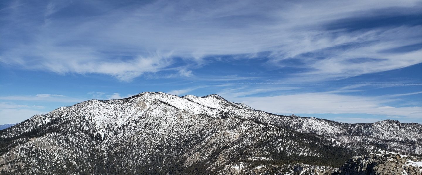
Early on Monday 25th April we ascended via Marion Mountain and Deer Springs trails to San Jacinto Peak, descending via the East Ridge, Peak, Wellman’s, PCT, and Devil’s Slide trails. This loop also facilitated survey of the highest parts of the PCT in the San Jacinto mountains (roughly PCT Miles 179-181 and 185-186) plus several of its side trails.
For the third Peak ascent in the past six days my spikes went unused, even for descending. Of the 16 PCT hikers I talked with on our loop on 25th, none were using (or even carrying) spikes.
Hikers may find spikes remain useful in a few areas above about 8000 ft (generally discussed below), depending on individual comfort level and experience on patches of icy snow, where snow on trails is compacted by hiker traffic and following freeze-thaw cycles. In general spikes are no longer required, especially on extensively melted and/or well-traveled trails with defined snow steps. Spikes remain most useful for descending, especially for the first few hundred feet of elevation down from the highest peaks. Spikes remain recommended in certain locations, such as the north side of Tahquitz Peak.
Snow depths, such as they are, measured on 25th April are given below. Current conditions for individual trails are discussed in detail below where known.
Despite periodic warmer temperatures, hikers should nevertheless be prepared for temperatures near freezing in the high country, and below freezing when considering wind chill effects (see below for some of my most recent weather observations from San Jacinto Peak).
The USFS gates at Humber Park and South Ridge Road are open, and those areas are clear of snow. South Ridge Road was partially graded in mid April, removing the most uneven sections. Santa Rosa Road (7S02) reopened on 7th April. Black Mountain (4S01) and Dark Canyon (5S02) roads remain in winter closure (for vehicle traffic only).
The Forest Service ranger station in Idyllwild, closed for more than two years (originally due to the coronavirus pandemic), is now tentatively scheduled to reopen in May 2022.
WEATHER
Temperatures are forecast to be generally around seasonal for the remainder of April, with the exception of a cooler day on Thursday 28th, warming to above seasonal for the first ten days of May (and well above seasonal in the high country). There is no further precipitation in the forecasts.
The first three months of the year combined to be the second driest ever here in Riverside County, and the driest on record for the entire northern half of California (NWS data). The Sierra snowpack, at an impressive 160% of average on 1st January, was only 38% of average by 1st April. In the San Jacinto mountains precipitation has been below average in the high country for the tenth consecutive winter (and eight of those ten winters, including the past three seasons, have been well below average).
At San Jacinto Peak (10,810ft/3295m) on Monday 25th April 2022 at 0825 the air temperature was 40.8°F (5°C), with a windchill temperature of 38.3°F (4°C), 23% relative humidity, and a barely perceptible SE breeze sustained at 1 mph gusting to 2.6 mph.
At the Peak on Friday 22nd April 2022 at 1130 the air temperature was 16.5°F (-9°C), with a windchill temperature of -11.7°F (-24°C), 98% relative humidity, and a wild WSW wind sustained at 23 mph gusting to 47.3 mph. The latter was the strongest wind gust reliably recorded at San Jacinto Peak this winter.
At the Peak on Wednesday 20th April 2022 at 0750 the air temperature was 30.5°F (-1°C), with a windchill temperature of 12.1°F (-11°C), 61% relative humidity, and a strong due West wind sustained at 22 mph gusting to 32.1 mph.
TRAIL CONDITIONS
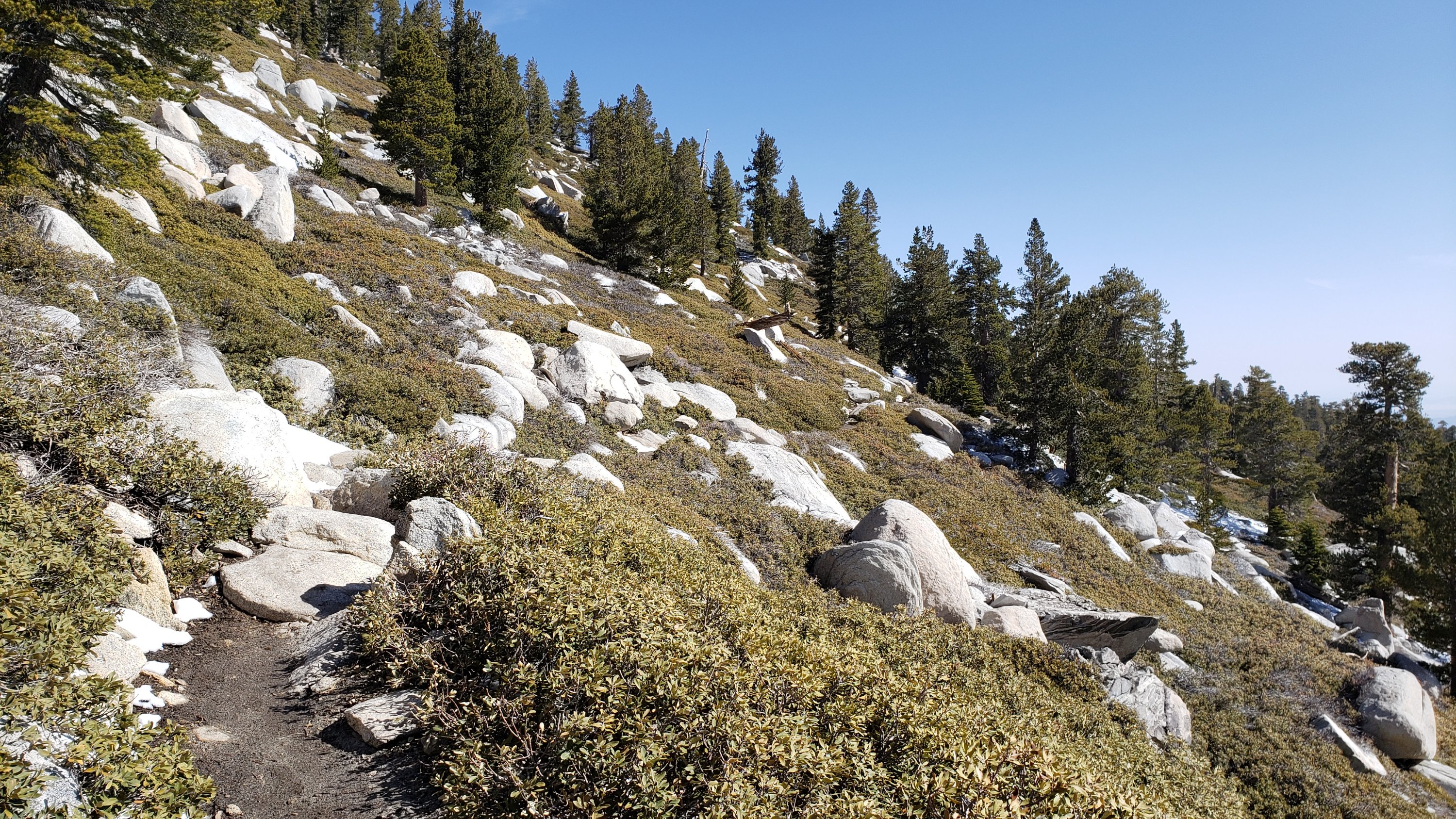
Trails below about 8700ft are largely or completely clear of snow, and thin patchy snow cover is increasingly limited above that elevation.
Effective Tuesday 1st February 2022 the State Park closed the section of Skyline Trail that falls within its jurisdiction, above 5800 ft elevation, “due to dangerous ice accumulation” (Skyline Trail forms the lower two-thirds of the “Cactus-to-Clouds” [C2C] route). The Superintendent stated on 25th April “we are monitoring weather conditions and the route and hope to reopen in the coming weeks”. The State Park boundary is not marked but is near the site of the old Florian’s Cache, below Flat Rock.
Due to greatly reduced maintenance work by the agencies and PCTA during the coronavirus pandemic, many trails have accumulated treefall hazards since late 2019, passable with care by hikers but not for stock. Although reported promptly, most hazards were not removed in 2021. With storms this season being accompanied by strong winds and heavy ice loads, hikers should expect to encounter many new and additional hazards, especially in vulnerable burn areas (e.g., Willow Creek Trail, PCT Miles 170-177).
Although some treefall hazards from Red Tahquitz to Antsell Rock (PCT Miles 172.5-175) were cleared in June 2021 prior to the rockslide removal work, the situation has badly deteriorated this winter. In a full survey in March 2022, I counted at least 72 treefall hazards between PCT Miles 170-175. At least a third of these are major hazards that require scrambling over or around.
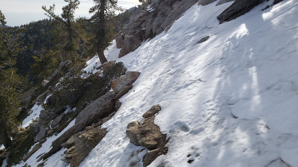
The 0.4 mile section of South Ridge Trail to Tahquitz Peak from Chinquapin Flat/PCT Mile 178 is clearing rapidly. However one extended patch of angled icy snow remains for which spikes, or even better crampons and ice axe, are required (see photo above).
The following trails below 8800 ft elevation are completely clear of snow/ice: Ernie Maxwell, Devil’s Slide, Suicide Rock, South Ridge (south from Tahquitz Peak), all Garner Valley trails.
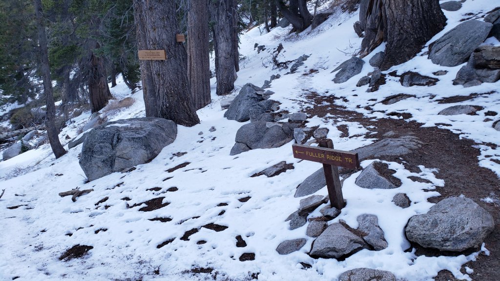
The PCT is functionally clear of snow from Mile 151 to 175 (Red Tahquitz). A few tiny patches remain on the north-east side of Apache Peak but will clear in the next day or two. Snow cover remains about 40% between Miles 175-178, and some hikers are finding that spikes remain useful for those few miles. Snow cover is now limited between Miles 178 to 184, with the exception of the notoriously stubborn half mile just south of Annie’s Junction starting at about Mile 180.3. Some lengthy snow patches remain on the sheltered sections of Fuller Ridge (notably Miles 188-189.5)
Snow cover now only averages 10% on the Peak Trail, persisting in the handful of traditional areas that are less sun-exposed (e.g., around 9900-10,100 ft). Spikes are generally not required for ascending, but may be useful in places for descending. A posthole snow route on the East Ridge still has >95% snow cover but is becoming increasingly uneven due to melting.
The Wellman Trail is almost clear of snow, other than the first 0.3 mile north of Annie’s Junction.
Marion Mountain Trail has about 10% cover of thin, patchy, icy snow, largely above 7600 ft elevation. Spikes are not required. There is one huge new treefall hazard across the trail exactly at the State Park/Forest Service boundary.
Deer Springs Trail is functionally clear of snow to about 8600ft (c.0.2 mile south of Marion Mountain Trail junction). Thereafter snow cover is a patchy 50% to about 9300 ft. Above that elevation snow cover currently averages 70%, but will melt rapidly in the next few days. Snow is most extensive (90%) in Little Round Valley. Above Little Round Valley snow cover averages 60%, with the first switchbacks above LRV, and those closest to Summit Junction, rapidly clearing of snow. Most hikers will find spikes useful, especially for descending. (Three new trees came down in late 2021 on the PCT/Deer Springs Trail just south of its junction with Marion Mountain Trail, but they are readily passable for hikers.)
South Ridge Trail (south of Tahquitz Peak) [checked 26th April] is clear of snow to Tahquitz Peak and spikes are not required. The middle section of South Ridge Trail (between May Valley Road and the top of South Ridge Road) has several trees down which are significant obstructions.
Willow Creek Trail has less than 30% snow cover overall, with most remaining snow expected to melt in the next few days. However there are at least 40 downed trees between Skunk Cabbage Junction and Hidden Divide, nearly 30 of these on the Forest Service section.
Spitler Peak Trail is functionally clear of snow. Forty downed trees, most from an ice storm in late December 2021, plus dozens of additional trunks and branches in the trail, have been removed by the Trail Report from this trail in early 2022.
The Caramba Trail from near Reeds Meadow through Laws Camp and on to Caramba, and the Cedar Trail from Willow Creek Trail to Laws, are optimistically described by the Forest Service as “not maintained”. In reality both trails no longer exist and are so heavily overgrown I advise hikers do not attempt to follow them. An informal use trail to Laws is much more direct and avoids all of the very challenging bushwhacking of the unmaintained trails (some local hikers dubbed it the “King Trail” when I established the route in 2019). It leaves the Willow Creek Trail exactly 1.0 mile from Saddle Junction (0.46 mile from the Skunk Cabbage turning), descending largely on established deer trails for 1.2 miles, meeting Willow Creek just upstream from the old Laws Camp. From Laws east to Caramba the route of the original Caramba Trail has been well-cairned by myself and others and can largely be followed with very careful route-finding. My February 2022 survey counted 97 trees down on this 2.1 miles of trail. It is especially obscure 0.1-0.3 mile east of the Willow Creek crossing, generally becoming clearer near Caramba. Cautious navigation is advised throughout the area.
Seven Pines Trail is functionally clear of snow to 7500 ft. Above that elevation snow cover is a patchy 30%. This trail has had very limited hiker traffic since November 2018, largely because Dark Canyon Road was closed from February 2019 to early October 2021, and again since December 2021. The Trail Report has “adopted” Seven Pines Trail as a priority for maintenance work as the trail has had a disproportionate number of lost hiker rescues in recent years. Starting in November 2021, 42 downed trees on the lower 3.0 miles of trail have been removed. Almost all of this section has also been thoroughly trimmed and cleared, and the trail is now obvious and easy to follow for much of its length (when clear of snow). However at least 18 downed trees remain on the upper 0.7 mile of trail, the route is very obscure in places (especially in snow conditions), and cautious navigation is essential for those who do not have extensive experience of hiking this trail. Dark Canyon campground remains closed.
SNOW DEPTHS measured on Monday 25th April 2022 are as follows. Where known, the fresh snowfall following the minor storm on Friday 22nd April 2022 is given in parentheses. As mentioned in previous Reports, although many areas retain some extensive patches of snow from December and February storms, average measurements were functionally zero inches in all locations immediately prior to 22nd April. Note that there was considerable drifting in the trails in the latest storm. Altitudes are approximate.
San Jacinto Peak (10810 ft): 1-2 inches (5 inches on 22nd April)
Little Round Valley (9800 ft): 3-5 inches
Wellman Divide (9700 ft): 0 inches (3.5 inches on 22nd April)
Annie’s Junction/approx. PCT Mile 180.8 (9070 ft): 2 inches (3.5 inches on 22nd April)
Seven Pines Trail junction with Deer Springs Trail/approx. PCT Mile 184.9 (8700 ft): 1 inch
Saddle Junction/approx. PCT Mile 179 (8070 ft): 0 inches (2.5 inches on 22nd April)
Devil’s Slide Trail at Humber Park (6520 ft): 0 inches (1.5 inches on 22nd April, largely melted by that afternoon)
Marion Mountain trailhead (6300 ft): 0 inches
Idyllwild (at 5550 ft): 0 inches (<0.25 inch on 22nd April 2022, all melted by that afternoon)
PACIFIC CREST TRAIL
Detailed snow conditions on the PCT are described above under “Trail Conditions”.
This has been a well-below average snow year for the San Jacinto high country (for the third season in a row, and now for eight of the past ten winters). Given rapid climate change here there could well be relatively little snow and ice by the time you reach the San Jacinto mountains. Nevertheless even small, isolated sections of icy snow can be challenging, especially for those with limited experience of snow/ice hiking. Details of current snow/ice conditions will be clear from updates to the Trail Report over coming weeks.
The rockslide at PCT Mile 172.5, just north of Antsell Rock, was removed on 14th June 2021. My “before, during, and after” video is available here. This section of the PCT is now safer and is narrow but readily passable with care by hikers (but remains impassable by stock).
If you take an alternate further south, it is possible to regain the PCT from Idyllwild via Devil’s Slide Trail at Saddle Junction (about Mile 179.5). Do not attempt to regain the PCT via South Ridge Trail as the slope on the north side of Tahquitz Peak always remains ice-covered well into April, requires spikes (at least), and is notoriously treacherous.
Black Mountain Road is not closed to hiker traffic, only to vehicles. This is a temporary, seasonal closure, and usually it reopens to vehicles in April or May (although that is weather and/or maintenance dependent).
PCT hikers are reminded that overnight stays are not permitted at or near San Jacinto Peak, including in the historic shelter. Mt. San Jacinto State Park permits overnight stays only in established campgrounds. Little Round Valley and Strawberry Junction are good options for thru-hikers.
It’s northbound PCT season! Please help the Trail Report at our busiest time of the year. While all labor and time is volunteered, the San Jacinto Trail Report completely depends on your small private donations to cover costs. Your contribution helps to keep the Report active, free from advertising, and independent from agencies. If you have found this Report useful, please visit the Donate page. Zelle, Venmo, and PayPal are all now options. Thank you for your support.


Great report! Thank you.
LikeLike