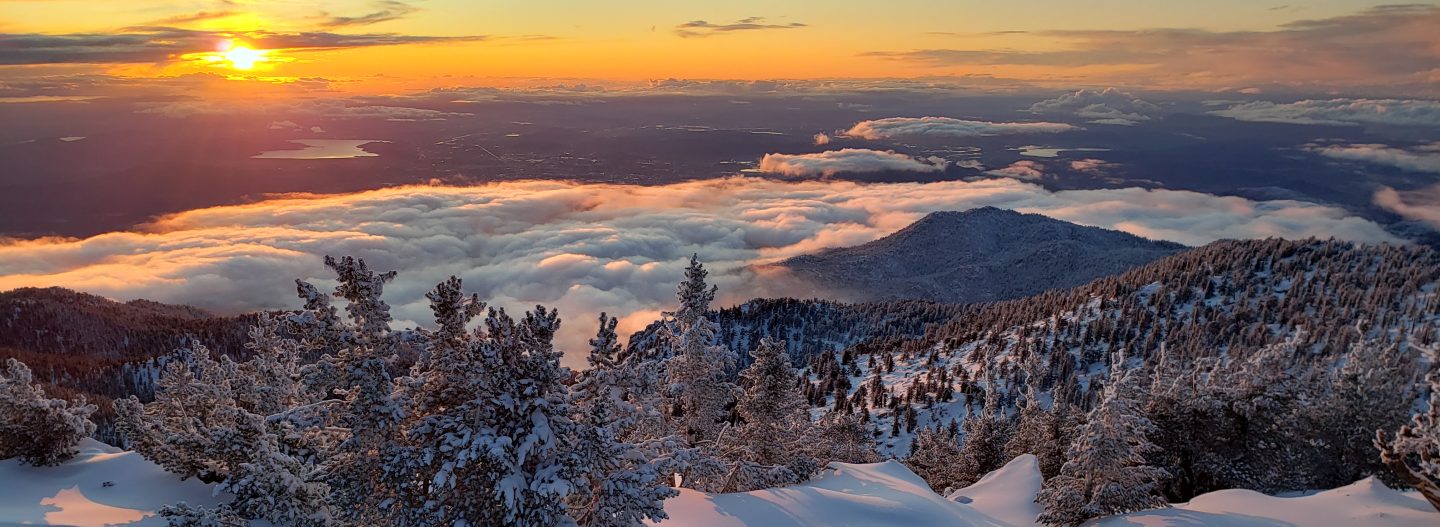
The third and most significant snowstorm of the 2021/22 winter to date passed through the San Jacinto mountains on Tuesday 14th December, as described in detail in the previous Report. About nine inches fell at San Jacinto Peak (10,810ft) and about an inch in Idyllwild. It rained steadily at mid elevations before turning to snow, with 1.43 inches measured at 5550ft in Idyllwild.
The storm included strong, gusty winds, and drifting of snow was particularly severe. These winds, combined with trees heavily laden with ice, led to many new treefall hazards (both broken branches and whole trees). For example on May Valley Road on 16th I found seven trees down across the road (reported to USFS), and on 20th found three new trees down on a short section of Deer Springs Trail. Hikers should expect to find new treefall hazards on trails, especially in burn areas.
Although temperatures have been at or even slightly above seasonal averages since the storm, melting has been very slow everywhere above 5000ft, with the sun at its lowest potency of the year this week.
This morning we ascended San Jacinto Peak via the east side (Devil’s Slide, Wellman and Peak trails) and descended via Deer Springs Trail. This allowed for thorough survey of snow and treefall conditions on most of the high country trail system.
Rarely have I seen the weather forecasts for the San Jacinto mountains so variable and inconsistent as they are for the remainder of December 2021. The latest details are given in Weather below, but in summary the period is expected to be very unsettled, with precipitation possible almost any day in the next two weeks. Consequently trail conditions, and required equipment, could change frequently and at short notice.
Hikers should be prepared for temperatures below freezing in the high country, and generally well below freezing when considering wind chill effects (see below for my recent weather observations from San Jacinto Peak).
Spikes are strongly recommended everywhere above about 6000ft for the foreseeable future as well-used trails are compacted by hiker traffic and undergo further freeze-thaw cycles. They are especially valuable on icy consolidated tracks and for descending (details of individual trails are given below). Snow depths are currently adequate for snowshoeing everywhere off-trail above about 9000ft although they are not essential depending on your comfort level with light postholing in relatively shallow snow. They are not advised on the main trails, which are largely too compacted for comfortable snowshoeing.
The USFS gate at Humber Park closed on 13th December. Even when closed there are nine legal parking spaces just below the gate. In recent winters vehicles not parked in these spaces have periodically been ticketed and/or towed, usually at weekends or immediately following snow storms. When “Road Closed” signs are in place further down Fern Valley Road, these nine spaces are also unavailable for legal parking (according to CHP).
The Marion Mountain trailhead remains open. However Azalea Trail, the access road, has not been plowed, is extensively ice-covered and treacherous, and is 4WD/AWD passable only.
For details regarding pre-existing (non snow/ice) hazards on the trails, coronavirus issues and ranger station access, please see this recent Report or contact the State Park or Forest Service as indicated on their websites.
WEATHER Temperatures above seasonal averages, such as those we experienced this weekend, will continue until Wednesday 22nd. Forecast resolution remains relatively poor for the rest of December, but unsettled weather into early January is expected, with below average temperatures from 23rd December onwards, plus snow (high country) and moderate rain with dustings of snow (mid elevations). Moderate to heavy precipitation is expected on 23rd-24th, with 12+ inches of snow at the highest peaks and 2-3 inches of rain at Idyllwild elevation. The freeze level may be as high as 7000ft, so snow currently at mid elevations may be washed away by rain. Lighter precipitation is possible again on 25th and from 29th into early January 2022, but frankly could also occur any day for the remainder of December.
At San Jacinto Peak (10,810ft/3295m) on Monday 20th December 2021 at 0940 the air temperature was 33.8°F (1°C), with a windchill temperature of 23.4°F (-5°C), 17% relative humidity, and a gentle WSW wind sustained at 6 mph gusting to 10.8 mph.
At the Peak on Wednesday 15th December 2021 at 0640 the air temperature was 22.1°F (-6°C), with a windchill temperature of 0°F (-18°C), 31% relative humidity, and a gusty NW wind sustained at 21 mph gusting to 33.5 mph.
At the Peak on Tuesday 14th December 2021 at 1630 the air temperature was 10.4°F (-12°C), with a windchill temperature of -17.5°F (-27.5°C), 93% relative humidity, and a wild WNW wind sustained at 21 mph gusting to 32.5 mph.
TRAIL CONDITIONS
Note that conditions may change starting 23rd December when significant additional precipitation is possible, potentially adding light powder on top of ice and icy snow in the high country, and ice (initially falling as rain) to surfaces at mid elevations.
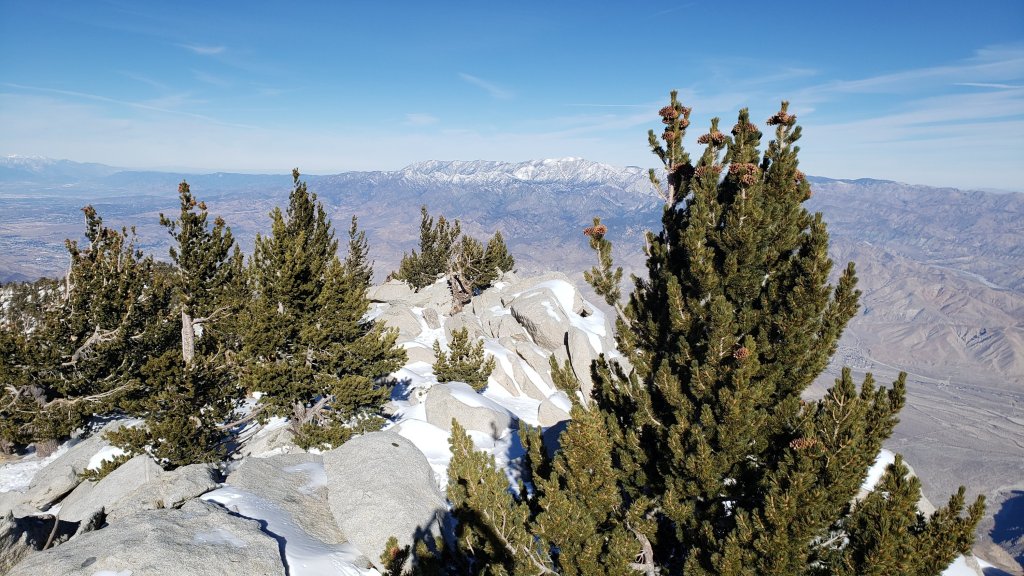
All trails above about 6000′ are largely or completely snow- and ice-covered. However, reliable and relatively prominent tracks are in place for almost all major trails as described below.
Tahquitz Peak trail from Chinquapin Flat/PCT Mile 178 has steps to follow through the angled icy snow. These icy slopes are notoriously treacherous. Currently spikes are strongly recommended. Snowshoes are rarely advisable on these slopes due to the angle of the icy snow.
The Ernie Maxwell Trail is almost completely covered with ice and compacted icy snow, and spikes are strongly recommended.
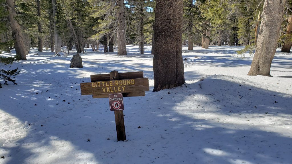
Deer Springs Trail has an excellent track to follow, well-traveled to Little Round Valley following the established trail route. Above Little Round Valley several different tracks meander up to the Peak, none of which accurately follow the actual trail for more than short sections, but several of which are relatively easy to follow.
Devil’s Slide and Marion Mountain trails have very well-traveled tracks to follow.
There are reasonable tracks to follow through the light snow around the Tahquitz meadows trail complex.
The Wellman Trail has been lightly traveled, and involves some uneven postholing through shallow snow, but there are a few tracks to follow.
There is a very well-traveled and consolidated trail from Long Valley through to Wellman Divide, which continues up the Peak Trail.
Spitler Peak Trail [updated 22nd] is virtually clear of snow. However there are six new trees down, all in the upper mile of the trail, including two major obstructions that require caution to get around.
Seven Pines Trail has a reasonable set of tracks to follow through the snow, although the track wanders from the established trail in its uppermost section. Dark Canyon Road is almost completely covered in 1-2 inches of snow, and is 4WD/AWD passable only.
There were no visible hiker tracks on Fuller Ridge Trail as of this afternoon.
May Valley Road is largely clear of snow, however it is largely impassable by vehicles due to multiple trees down (mentioned above, reported to USFS).
There is well-defined track on the Suicide Rock Trail through the snow from Deer Springs Trail.
SNOW DEPTHS measured on 20th December 2021, are as follows. Note that current average total depth is given first, followed in parentheses by the depth after the storm of 14th where known. Due to strong winds accompanying the storm there is extensive drifting, especially in and near the trails. Altitudes are approximate. Locations are listed in descending order by altitude.
San Jacinto Peak (10810ft): 8 inches (very heavily drifted; was 11 inches on 15th)
Little Round Valley (9800ft): 6 inches
Wellman Divide (9700ft): 3 inches (was 6.5 inches on 15th)
Annie’s Junction/approx. PCT Mile 181.8 (9070ft): 4 inches (was 5 inches on 15th)
Deer Springs Trail at Seven Pines Trail junction (8700ft): 4 inches
Strawberry Junction (8100ft): 1 inch
Saddle Junction/approx. PCT Mile 179.9 (8070ft): 2 inches (was 3 inches on 15th)
Deer Springs Trail at Suicide Rock Trail junction (6950ft): <1 inch (patchy, largely melted)
Devil’s Slide Trail at Humber Park (6520ft): <1 inch (2 inches on 15th)
Idyllwild (at 5550ft): 0.5 inch (very patchy, largely melted, was 1 inch on 15th)

Thank you fellow hikers for taking the time to read this. While all labor and time is volunteered, the San Jacinto Trail Report completely depends on small private donations to cover operating costs. Every year seems to have its challenges and 2021 has been no exception, so every contribution, no matter how small, is truly valuable. If you have found this Report useful, please consider visiting the Donate page. Thank you for your support.


