November 2021 will likely set a number of unwanted meteorological records, most notably being the first November in recorded history with no snowfall in the San Jacinto high country. It will certainly be the driest November, and probably the warmest, since local records began. Although unfortunate for many other reasons, dry conditions with benign temperatures have been ideal for making major progress on trail maintenance, with continued focus on Seven Pines Trail, South Ridge Trail, and Spitler Peak Trail.
Santa Ana wind events peak in frequency in December and January (as discussed in this NWS San Diego video). Another major event is forecast for 24th-26th November, with extremely low humidity expected. Dry north-east winds prevail until 2nd December.
Full fire restrictions remain in place on Forest Service lands, as described here. All campfires anywhere in the San Jacinto mountains, including at all USFS campgrounds and yellow post sites, are prohibited. All forms of campfire are always prohibited in wilderness (State Park and USFS lands). With unseasonably warm, dry conditions, and periodic Santa Ana wind events, fire risk remains very high.
The effects of the light precipitation from multiple storms in October rapidly dissipated regionally (as mentioned in another NWS video) and water conditions in the high country continue to deteriorate further. Many springs and creeks dried months ago. The current status of most key water sources is discussed below.
Most major Forest Service campgrounds closed for the season earlier this month, along with the State Park Stone Creek campground (Marion Mountain will close 1st December, no water available). The State Park campground at the Idyllwild Ranger Station normally remains open all year. Black Mountain fire lookout closed on 13th, and Tahquitz Peak lookout on 20th November.
Despite recent relatively warm days, hikers should nevertheless be prepared for temperatures near or below freezing around the highest peaks (>10,000ft), and potentially well below freezing when considering wind chill effects (see below for most recent weather observations from San Jacinto Peak).
Be bear aware. Although rarely reported, several Black Bears remain active in the San Jacinto mountains. I was fortunate to see a very large (>300lb) uniformly dark brown individual at dawn on 7th September near Humber Park. I was able to get a couple of short, poor quality videos, of which one is available here.
The U.S. Forest Service ranger station in Idyllwild has been closed due to USFS coronavirus protocols since March 2020. Apparently it will not reopen until 2022. Hiking and camping permits are nevertheless required for USFS lands, and should be available at the kiosk outside the ranger station.
The State Park ranger station has been open almost all year, and is the best source in Idyllwild for permits and additional trail information.
WEATHER The current three day cool spell, in which temperatures are around seasonal averages, continues until Thursday 25th November. Thereafter a strong warming trend will bring temperatures far above seasonal for the last few days of November and into the first week of December. North-east winds, accompanied by very low relative humidity, are forecast for the next ten days. Regrettably there continues to be no significant precipitation in the forecast.
At San Jacinto Peak (10,810ft/3295m) on Wednesday 24th November 2021 at 0830 the air temperature was 30.7°F (-1°C), with a windchill temperature of 20.1°F (-7°C), 31% relative humidity, and a cool NNE wind sustained at 5 mph gusting to 9.1 mph.
At the Peak (10,810ft/3295m) on Monday 22nd November 2021 at 0905 the air temperature was 38.1°F (3°C), with a windchill temperature of 26.7°F (-3°C), 36% relative humidity, and a sharp SSE wind sustained at 9 mph gusting to 17.3 mph.
TRAIL CONDITIONS
Trails throughout the San Jacinto high country cleared several weeks ago of the very light snow that fell in late October, and spikes are not required anywhere. Water conditions remain challenging despite five minor storms in October, with many springs and creeks already having dried up or having very low flows, as discussed in detail below. To date, temperatures have not been low enough to freeze springs in the high country, although on the morning of Monday 22nd most of the North Fork of the San Jacinto River where it crosses Fuller Ridge Trail was solidly frozen (some unfrozen pools remained just upstream).
The rockslide at PCT Mile 172.5, just north of Antsell Rock, was removed on Monday 14th June 2021. My “before, during, and after” video is available here. This section of the PCT is now safer and is narrow but readily passable with care by hikers (but remains impassable by stock).
Due to greatly reduced maintenance work by the agencies and PCTA during the coronavirus pandemic, many trails have accumulated treefall hazards since late 2019, passable with care by hikers but not for stock. Although reported promptly, regrettably neither Forest Service nor State Park have moved quickly to remove most hazards in 2021. With Santa Ana events and recent storms being accompanied by strong winds, hikers may encounter some new and additional hazards. Some are described below, others include the PCT between Strawberry Cienega and Strawberry Junction (PCT Miles 182-183, at least 7 trees down), and Fuller Ridge Trail near its northern end (PCT Miles 189.1-190.2, three trees).
Willow Creek Trail has at least 33 downed trees between Skunk Cabbage Junction and Hidden Divide. Of these 22 are on the Forest Service section (16 between Willow Creek and the Park boundary), with 11 in the State Park. Most are readily passable by hikers with care. Despite so much work last year by USFS volunteer Bill Rhoads and myself, the whitethorn has grown back rapidly, but still remains much less challenging than in 2019.
Spitler Peak Trail was cleared of multiple tree hazards by the Trail Report in early July, and has been trimmed periodically throughout 2021.
Marion Mountain Trail was cleared of multiple tree hazards by a California Conservation Corps team in late August, along with the adjacent PCT/Deer Springs Trail for 0.6 mile north to the south end of Fuller Ridge Trail. One new tree came down in early November 2021 on the PCT just yards south of its junction with Marion Mountain Trail, but it is easily passable for hikers.
Many treefall hazards from Red Tahquitz to Antsell Rock (PCT Miles 172.5-175) were cleared in June prior to the rockslide removal work mentioned above. Nevertheless about 20 remain, including at least six major obstructions for hikers. Tahquitz Creek to Red Tahquitz (PCT Miles 175-177) was cleared in early June.
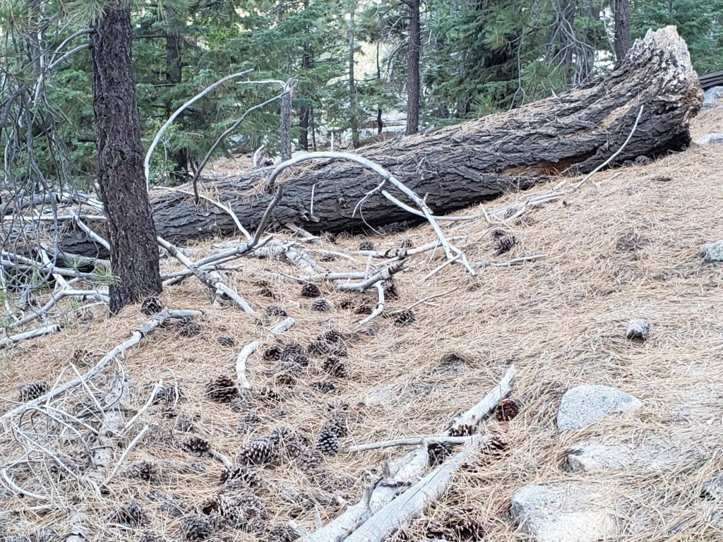
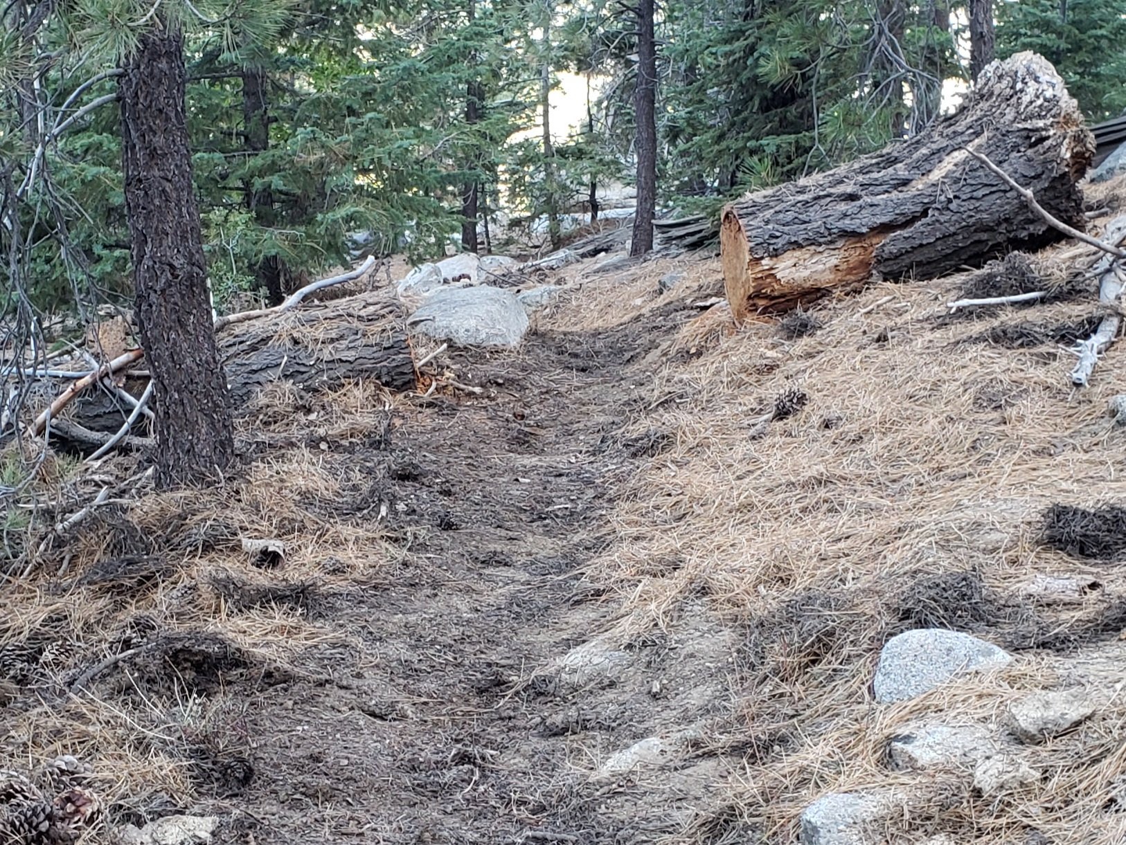
Seven Pines Trail has had limited hiker traffic since November 2018, largely because Dark Canyon Road was closed between February 2019 and early October 2021. The Trail Report has “adopted” Seven Pines Trail as a priority for maintenance work to improve hiker safety on a trail which has had a disproportionate number of lost hiker rescues in recent years. In November 2021, all 22 major treefall hazards on the lower 2.4 miles of trail have been removed, plus a couple more further up. The lower 1.5 miles have also been trimmed and cleared, with less systematic trimming for another mile further up also. The trail is now obvious and easy to follow in this lower section. However 33 treefall hazards remain on the upper trail, the route is very obscure in places, and cautious navigation is required for those who are not very familiar with hiking this trail. Dark Canyon campground remains closed.
The Caramba Trail from near Reeds Meadow through Laws Camp and on to Caramba, and the Cedar Trail from Willow Creek Trail to Laws (which both nominally reopened in late 2018) are optimistically described by the Forest Service as “not maintained”. In reality parts of these trails no longer exist with significant sections of both so heavily overgrown that I strongly advise hikers do not attempt to follow them. Multiple experienced hikers have reported getting lost in this area since summer 2019. An informal use trail to the Laws Camp area is much more direct and completely avoids all of the challenging bush-whacking of the unmaintained trails (other hikers kindly nicknamed it the “King Trail”). It leaves Willow Creek Trail exactly 1.0 mile from Saddle Junction, 0.45 mile from the Skunk Cabbage turning (trailhead at N33°46’46”, W116°39’32”, WGS84). The cairned use trail descends largely on established deer tracks for 0.9 mile, reaching Willow Creek just upstream of the former site of Laws Camp. From Laws east to Caramba the route of the old Caramba Trail has become increasingly tricky to follow, especially for the first 1.2 miles east of Laws where there are dozens of trees down. Closer to Caramba the trail is relatively obvious (for those familiar with the route prior to the 2013 Mountain Fire). Very cautious navigation is recommended throughout this area.
WATER STATUS: Eastern slope
The Round Valley pipe is now flowing only intermittently and is no longer reliable. Creeks in Round Valley and Tamarack Valley were dry in May (in 2020 neither dried until August).
Hidden Lake dried up completely in June.
Both the northern and southern springs at Wellman’s Cienega are flowing gently (but adequately to filter). These are the sources for Willow Creek, which is flowing where it crosses the Willow Creek Trail (the flow remains good for filtering, but is the lowest I have ever seen this creek). Sections of the creek are dry near Laws Camp (the creek presumably sustained by subsurface flow).
Tahquitz Creek is flowing at the northern end of Little Tahquitz Meadow. It is also flowing gently further upstream at its source (known colloquially as Grethe Spring) where it crosses the PCT at approx. Mile 177.
The small creek in Tahquitz Valley dried in May, some four months earlier than in 2020.
Candy’s Creek – that flows through Skunk Cabbage Meadow and then crosses the remaining visible section of Caramba Trail near Reeds Meadow – dried up in early July.
WATER STATUS: Western slope
The North Fork of the San Jacinto River continues to flow gently where it crosses the Deer Springs Trail, and also very weakly where it crosses the Fuller Ridge Trail on the PCT (approx. PCT Mile 186.2). Less than two miles further downstream this river is, remarkably, completely dry (see photos in an earlier report here).
The creek in Little Round Valley completely dried up in early July, reminiscent of the extremely dry years of 2014-16. The same creek dried up where it crosses Fuller Ridge Trail (PCT Mile 186.4) in April.
Shooting Star Spring (not far below Little Round Valley but above the North Fork of the San Jacinto River crossing) is flowing weakly and is a very poor option for filtering.
The Deer Springs stream crossing is dry at the PCT/Deer Springs Trail (approx. PCT mile 185.6). (Despite some online mapping to the contrary, this is NOT the source for the North Fork of the San Jacinto River.)
The tiny but perennial spring about 0.4 miles north of Strawberry Junction (known colloquially as Switchback Spring) continues to flow remarkably well. I rework the tiny pool every week when I pass by and there is sufficient depth from which to filter water.
The little creek at Strawberry Cienega (PCT mile 183.0) is dry.
On Devil’s Slide Trail all springs have been dry for many months.
On the Ernie Maxwell Trail, the crossing of Chinquapin Creek just below Humber Park is currently flowing where it crosses the trail. Even when the creek is dry across the trail, small but invaluable fresh pools remain just upslope from the trail (this creek is an especially useful source of water for the many dogs walked on this trail).
The faucet at Cinco Poses Spring about 4.5 miles up Black Mountain Road continues to flow.
WATER STATUS: Desert Divide
Live Oak Spring (N 33 37 21, W 116 33 24) Flowing. The most reliable water source on the Desert Divide.
Cedar Spring (N 33 40 36, W 116 34 35) Flowing weakly. Easiest access is the trough about 60 yards upstream from the trail to the campsite.
Apache Spring (N 33 43 11, W 116 37 13) Barely trickling, not now reliable.
Spitler Peak Trail Descending the trail from the PCT there are five water crossings. The first two, at 0.9 and 0.95 miles down, cross a tiny side creek which is largely dry and should be ignored. The next crossing, at 1.1 miles down, is Spitler Creek and is the best source of water (currently flowing very gently, but can be filtered). The next two crossings are the same creek, also flowing adequately for filtering.
Antsell Rock Creek (N 33 41 52, W 116 39 08) Right by the Spitler Peak Trail trailhead on Apple Canyon Road, Antsell Rock Creek dried up in July. Even in the very dry years of 2015 and 2016, this source did not dry until the autumn.

Thank you for taking the time to read this. While all labor and time is volunteered, the San Jacinto Trail Report completely depends on small private donations to cover operating costs. Every year seems to be challenging and 2021 has been no exception, so every contribution, no matter how small, is truly valuable. If you have found this Report useful, please consider visiting the Donate page. Thank you for your support.

Thank you Jon for your report as always! Very upsetting to view the amount of trash you are STILL removing! Spitler Peak Trail in great shape having travelled Nov 20th! All of the work and clearing is very much appreciated! The large trees take a few minutes to navigate over with exposure… however very manageable. Camped at the base of Red Tahquitz at established area. Very pleasant night at freezing. Grethe Creek running nicely with a great pooling spot to filter water. Thank you for all the updates and management! The buckthorn aka whitethorn is a noticeable improvement due to your work on Willow Trail since I was on it a few months ago! THANK YOU!
LikeLike