Daily hikes have included San Jacinto Peak 2-3 times per week and Tahquitz Peak once a week, both by a variety of routes. Additional trails surveyed in the past week have included Seven Pines Trail, Laws area and lower Caramba Trail, Willow Creek Trail, and the Tahquitz/Skunk Cabbage meadow trail complex.
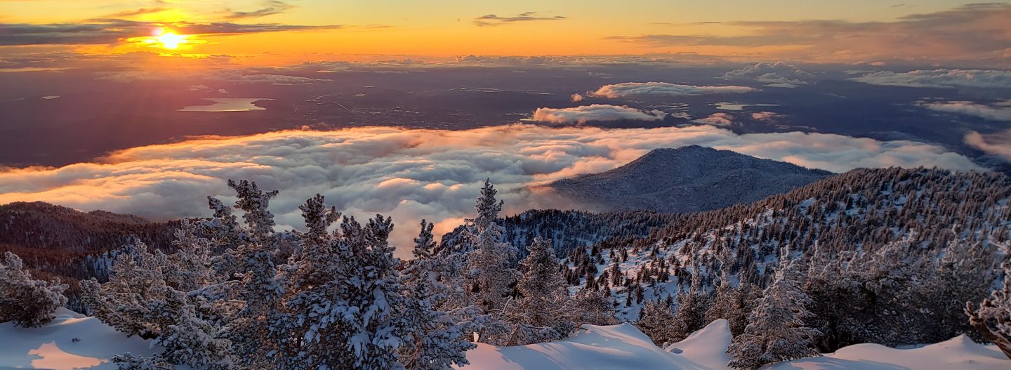
Trails throughout the San Jacinto high country have been clear of snow since early May. Water conditions in the high country are already worryingly reminiscent of the extremely dry years of 2015 and 2016. The status of many key springs and creeks is described below.
Be rattlesnake aware. Southern Pacific Rattlesnakes (Crotalus helleri) have already been seen on multiple trails at elevations close to 9000ft.
Be bear aware. Although reports have been very infrequent in the past two years, at least one Black Bear remains in the San Jacinto mountains. We found very fresh tracks on lower Seven Pines Trail on 22nd May.
The U.S. Forest Service ranger station in Idyllwild remains closed due to the coronavirus crisis. It is not expected to reopen before July. Hiking and camping permits are required for USFS lands, and are available at the kiosk outside the ranger station.
Black Mountain Road reopened on 23rd April, and the Black Mountain Fire Lookout on 23rd May. Boulder Basin campground reopened on 22nd May (having been closed for two years due to maintenance issues) along with other USFS seasonal campgrounds.
Tahquitz Peak Fire Lookout reopens for the season on Sunday 30th May. Note that visitors are currently unable to access fire lookouts when manned due to coronavirus protocols.
WEATHER Temperatures are forecast to be above seasonal averages into early June, with some days well above seasonal (especially overnight lows). The first week of June is forecast to have weather more typical of July-August. There is no precipitation in the forecast. Fire risk is high.
A brief but dramatic cooling on Friday 21st and Saturday 22nd May provided a reminder of how quickly conditions can change in the mountains. The cooling was accompanied by strong westerly winds, with windchill temperatures far below freezing in the high country.
At San Jacinto Peak (10,810ft/3295m) on Wednesday 26th May 2021 at 0720 the air temperature was 38.7°F (2°C), with a windchill temperature of 28.6°F (-2°C), 32% relative humidity, and a moderate WSW breeze sustained at 7 mph gusting to 13.2 mph.
At the Peak on Saturday 22nd May 2021 at 0805 the air temperature was 18.8°F (-7°C), with a windchill temperature of 5.8°F (-15°C), 47% relative humidity, and a fresh West breeze sustained at 4 mph gusting to 8.8 mph.
At the Peak on Friday 21st May 2021 at 0830 the air temperature was 13.4°F (-10°C), with a windchill temperature of -11.0°F (-24°C), 68% relative humidity, and a frigid due West wind sustained at 18 mph gusting to 30.1 mph.

TRAIL CONDITIONS
Trails throughout the San Jacinto high country are clear of snow. Regrettably water conditions are already becoming a concern, with most springs and creeks already having flows more typical of late summer at best.
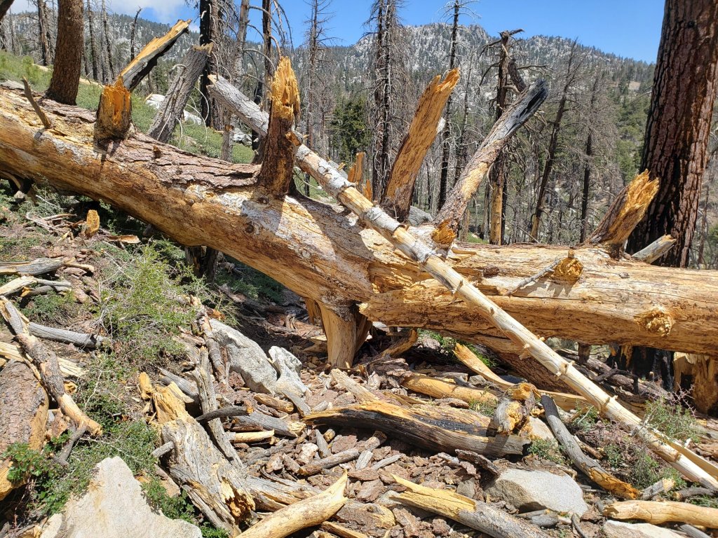
Many trails have accumulated treefall hazards from the past two winters, passable with care by hikers but not for stock. Some are described below, others include: PCT from Tahquitz Creek to the rockslide (PCT Miles 172.5-177, about 60 trees down), PCT between Strawberry Cienega and Deer Springs camp (PCT Miles 182-185, about 12 trees down), Fuller Ridge Trail near its northern end (PCT Miles 189.1-190.2, three trees), and upper Spitler Peak Trail (five trees). A trail crew is scheduled to work on the PCT section Miles 173-175 starting in June.
Willow Creek Trail has 12 downed trees on its Forest Service section, including a couple of large, heavily-branched trees that are somewhat challenging to pass. USFS has been notified.
The Caramba Trail from near Reeds Meadow through Laws Camp and on to Caramba, and the Cedar Trail from Willow Creek Trail to Laws (which both nominally reopened in late 2018) are optimistically described by the Forest Service as “not maintained”. In reality parts of these trails no longer exist with significant sections of both so heavily overgrown that I strongly advise hikers do not attempt to follow them. Experienced hikers have reported getting lost in this area since summer 2019. An informal use trail to the Laws area is much more direct and completely avoids all of the challenging bush-whacking of the unmaintained trails (local hikers have kindly dubbed it the “King Trail“). It leaves Willow Creek Trail exactly 1.0 mile from Saddle Junction, 0.45 mile from the Skunk Cabbage turning (trailhead at N33°46’46”, W116°39’32”, WGS84). The cairned trail descends largely on established deer tracks for 0.9 mile. Be advised that it is a use trail, becoming somewhat less obvious as it nears Willow Creek. From Laws east to Caramba the route of the old Caramba Trail has become increasingly tricky to follow, especially for the first 1.2 miles east of Laws. Closer to Caramba the trail is relatively obvious (for those familiar with the route prior to the 2013 Mountain Fire). Cautious navigation is required throughout this area.
Seven Pines Trail has had limited hiker traffic since November 2018. There are 35 treefall hazards on the trail, four large ones on the short Forest Service section, and the remainder in the State Park, based on my May 2021 survey. Cautious navigation is recommended for those who are not familiar with hiking this trail. Dark Canyon Road has been closed since early 2019, and there is no vehicular access to Seven Pines trailhead.
The PCT through the Snow Fire closure area (approx. PCT Miles 191-207) reopened on 3rd April 2021. Only the tread of the Trail has reopened, USFS is not permitting camping along the roughly 17 mile section.
The Pacific Crest Trail remains open at the rockslide north of Antsell Rock (Mile 172.5). Reports that the assisting rope around the rockslide is “in tatters” are misleading. However the rope is ageing and if you choose to use it you do so completely at your own risk. USFS has told the Trail Report that responsibility for removing the rockslide is currently with the PCTA, and that there are no imminent plans to close this section of the PCT for rock removal work. This video report (recorded on 1st March 2021, starts at minute 9.05) may be useful for deciding whether to hike around the rockslide.
The State Park reminds all hikers that overnight stays are not permitted at or near San Jacinto Peak, including in the historic shelter. This is especially critical during the coronavirus pandemic as it is impossible to adequately clean and sterilize the shelter. Mt. San Jacinto State Park regulations permit overnight stays only in established campgrounds. Strawberry Junction (approx. Mile 183) is a good option for thru-hikers.
WATER STATUS: Eastern slope
The Round Valley pipe is flowing. Creeks in Round Valley and Tamarack Valley are already dry (last year neither dried until August).
Both the northern and southern springs at Wellman’s Cienega are flowing gently. These are the sources for Willow Creek, which is flowing relatively weakly where it crosses the Willow Creek Trail.
Tahquitz Creek is flowing steadily at the northern end of Little Tahquitz Meadow. It is also flowing further upstream at its source (known locally as Grethe Spring) where it crosses the PCT at approx. PCT Mile 177.
The small creek in Tahquitz Valley is already dry where it crosses the trail, four months earlier than in 2020. However about 100 yards upstream there is some flow, with pools suitable for filtering.
Candy’s Creek – that flows through Skunk Cabbage Meadow and then crosses the remaining visible section of Caramba Trail near Reeds Meadow – is currently flowing gently in both locations.
WATER STATUS: Western slope
The North Fork of the San Jacinto River is flowing steadily where it crosses the Deer Springs Trail and again downstream where it crosses the Fuller Ridge Trail on the PCT (approx. PCT Mile 186.2).
The creek in Little Round Valley is flowing very weakly for only a few hundred feet and dries up before leaving the Valley. There will not be water in LRV beyond June this year. The same creek dried up where it crosses Fuller Ridge Trail (at about PCT Mile 186.4) in April.
Shooting Star Spring (below Little Round Valley but above the North Fork of the San Jacinto River crossing) is flowing weakly.
The Deer Springs stream crossing at the PCT (approx. PCT mile 185.6) is flowing gently.
Switchback Spring at PCT Mile 183.5 (about 0.4 miles on the PCT northbound from Strawberry Junction) is trickling. I reworked the tiny pool and there is just adequate depth from which to filter water.
The little creek at Strawberry Cienega (PCT mile 183.0) is dry.
On Devil’s Slide Trail, Middle Spring barely continues to trickle. Other springs on this trail are dry.
On the Ernie Maxwell Trail, the crossing of Chinquapin Creek just below Humber Park is already dry where it crosses the trail. However, there are small fresh pools just upslope from the trail (this creek is an important source of water for the many dogs walked on this trail).
WATER STATUS: Desert Divide
Live Oak Spring (N 33 37 21, W 116 33 24) Flowing well. The most reliable water source on the Desert Divide.
Cedar Spring (N 33 40 36, W 116 34 35) Flowing well. Easiest access is the trough 60 yards upstream from the trail to the campsite.
Apache Spring (N 33 43 11, W 116 37 13) Barely trickling.
Spitler Peak Trail Descending the trail there are five water crossings. The first two, at 0.9 and 0.95 miles down, cross a tiny side creek which is largely dry and should be ignored. The next crossing, at 1.1 miles down, is Spitler Creek and is the best source of water (currently flowing). The next two crossings are the same creek, but for obvious reasons it is best to fill up at the highest of the three crossings.
Antsell Rock Creek (N 33 41 52, W 116 39 08) Right by the Spitler Peak Trail trailhead on Apple Canyon Road, Antsell Rock Creek is flowing very well. Just on the upstream side of the road there is excellent access to the creek. Useful if hikers are descending the Spitler Peak Trail.
Thank you hikers for taking the time to read this. While labor and time is volunteered, the San Jacinto Trail Report completely depends on small private donations to cover costs. Every year seems to be challenging and 2021 has been no exception, so every contribution, no matter how small, is truly valuable. If you have found this Report useful, please consider visiting the Donate page. Thank you.

