[For information specific to the Pacific Crest Trail please see the dedicated PCT report, updated daily and best used in conjunction with this latest general Report.]
[UPDATED 19th March: Humber Park reopened for all parking this evening.]
[UPDATED 18th March: a short video describing conditions on the PCT at its junction with Spitler Peak Trail (Mile 168.5) is available here.]
The past week has seen the tenth, eleventh, and twelfth snow storms of winter 2020/21, the last of these yesterday. Conditions after the moderate storm of 10th-11th March were summarised in the previous Report. The two most recent storms produced much less precipitation, up to three inches of snow on 12th March, and 1-4 inches of snow yesterday.
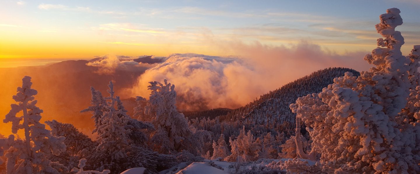
This morning I ascended San Jacinto Peak breaking trail via the east side (Devil’s Slide, Wellman, and Peak trails) and descended via Deer Springs Trail. This facilitated survey of the highest parts of the PCT in the San Jacinto mountains (roughly Miles 179-181 and 185.5-183.5) plus several of its feeder trails.
I recorded video on today’s hike to give a feel for current conditions especially at high elevation locations along the PCT (available here on YouTube, special thanks to my neighbour Alex Coleman for expert video production). Although excellent tracks are now in place for some major trails (discussed below), cautious navigation is strongly recommended everywhere for the next few days in particular.
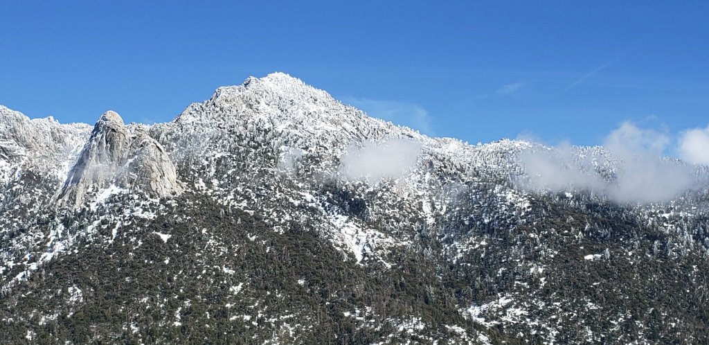
The storm system yesterday was warmer than others this winter, with rain initially as high as 6500ft before turning to snow. Coupled with cold overnight temperatures for the next couple of days, this creates hazardous conditions on slopes, where snow lies on top of ice (frozen rain), itself on top of older snow. Considerable caution and appropriate equipment are currently required everywhere, especially traditionally challenging slopes such as parts of PCT Miles 167-176, north face of Tahquitz Peak, north and east slopes of San Jacinto Peak, and Fuller Ridge, among others.
Current forecasts suggest that there may be no more precipitation for a couple of weeks, with warming and steady melting likely at most elevations. Days of freeze-thaw cycles will make the snow-ice conditions additionally challenging and variable.
As is increasingly the trend with a changed climate in recent years, there was little difference in snowfall between the mid and upper elevations in the storm yesterday, with 2.5 inches measured at Humber Park (at 6500ft) through to about 3.5 inches at San Jacinto Peak (10,810ft). Current overall snow depths for many locations around the mountain are given at the foot of this posting.
Snow conditions are currently ideal for snowshoeing everywhere above about 7000ft, potentially lower on less exposed trails for the next day or two. With steady melting already underway by this afternoon and compaction caused by freeze-thaw cycles and hiker traffic, conditions will deteriorate for snowshoeing over the next few days, especially on more heavily traveled trails below 9000ft. Nevertheless, snowshoes will be valuable anywhere off trail above about 8000ft for the foreseeable future. In addition to snowshoes, and as conditions change, spikes are strongly recommended for the foreseeable future everywhere above about 5500ft. They will be especially valuable on well-consolidated tracks over the next week (e.g., PCT, Devil’s Slide and Deer Springs trails) on colder mornings when conditions are icy, and for descending.
Hikers should be prepared for temperatures at or below freezing in the high country, and well below freezing when considering wind chill effects (see below for recent temperatures at San Jacinto Peak).
Snow depths are currently insufficient for significant avalanche risk in the high country, with the exception of the traditionally unstable north face of San Jacinto Peak (and possibly the north face of Tahquitz Peak).
The USFS gate at Humber Park was closed on 10th March. There is legal parking for nine vehicles only just below the gate. USFS has recently ticketed illegally parked vehicles. On snowy weekends this year the uppermost 0.1 mile of Fern Valley Road has been closed by CHP at its junction with Forest Drive. Although parking is normally legal along Forest Drive, CHP has periodically towed vehicles parked along that street. Exercise considerable caution when parking anywhere in this area especially during weekends.
South Ridge Road remains open, although the road is completely snow-covered and is becoming increasingly icy.
WEATHER Temperatures are forecast to fluctuate around seasonal averages at most elevations (but generally above average in the high country) for the next ten days. With many sunny days snow melt will steadily accelerate and will likely be particularly rapid below 8000ft and on sun-exposed slopes at all elevations. There is no significant precipitation in the forecast.
At San Jacinto Peak (10,810ft/3295m) on Tuesday 16th March 2021 at 1145 the air temperature was 21.2°F (-6°C), with a windchill temperature of 2.8°F (-16°C), 71% relative humidity, and a gusty NNW wind sustained at 12 mph gusting to 20.7 mph.
At the Peak on Friday 12th March 2021 at 1120 the air temperature was 10.2°F (-12°C), with a windchill temperature of 3.4°F (-16°C),100% relative humidity, and a light SW wind sustained at 2 mph gusting to 10.8 mph.
TRAIL CONDITIONS
All trails above about 5500′ are largely or completely snow-covered. By this afternoon, melting was already well underway below 7000′. Reliable tracks are currently only known to be in place for Devil’s Slide Trail through to San Jacinto Peak via Wellman Divide, and the entire Deer Springs Trail. At elevations below 10,000ft by this afternoon snow was softening rapidly, and was taking on the consistency of soft-serve ice cream even in the high country. This makes snowshoes even more valuable.
Tahquitz Peak trail from Chinquapin Flat/PCT Mile 178 has no steps to follow through the steeply angled icy snow. These icy slopes are treacherous. Currently crampons (with an ice axe) are strongly recommended. Snowshoes are not advised due to the angle of the icy snow.
Devil’s Slide Trail has a well-traveled track to follow.
The Ernie Maxwell Trail has a well-defined track to follow along its entire length.
There were no visible hiker tracks on Marion Mountain, Seven Pines, or Fuller Ridge trails, as of this afternoon.
Deer Springs Trail has an excellent snowshoe track to follow, well-traveled to Strawberry Junction, then a single set of tracks to Little Round Valley, all largely following the established trail route. Above Little Round Valley, my snowshoe track down from the Peak is very direct, steep, and would be a challenging ascent.
May Valley Road – a major component of the PCT Mile 168.5 alternate – is clear of snow [updated 17th March].
There is well-defined posthole track on the Suicide Rock Trail through the snow from Deer Springs Trail.
Spitler Peak Trail [updated 18th March] is almost clear of snow below the first creek crossing (about 6500ft elevation), but then snow cover is about 50% in the switchbacks up to the PCT. There is a well-defined track through most of this snow cover.
Current snow cover on the PCT is minimal from Miles 151 (Highway 74) to about 160, and increasingly patchy between Miles 160 and about 175 (Red Tahquitz), concentrated on north-facing slopes e.g., Spitler Peak (Mile 168) and Apache Peak (Mile 169.5-170). Note that in addition to the challenging north-east side of Apache Peak, the off-trail north side of the Apache saddle is also still largely snow-covered (also requiring spikes). Snow is then more-or-less continuous between Miles 175-191. Snow cover will become increasingly patchy between Miles 178 to 183.5 in the next few days, with the exception of the notoriously stubborn half mile just south of Annie’s Junction starting at about Mile 180.3. From Mile 183.5 to 191, snow is largely continuous, although some exposed sections of Fuller Ridge (e.g., parts of Miles 186.5-188.5) are thinning rapidly.
SNOW DEPTHS measured on 16th March 2021, are as follows. Note that current average total depth is given first, followed by added snow from the latest storm in parentheses where known. Note that there was some melting between the previous storm systems, accounting for the discrepancy between depths reported here and last weeks report. Due to strong winds accompanying the storms there is extensive drifting, especially in the trails. Altitudes are approximate.
San Jacinto Peak (10810ft): 38 inches (4 inches new snow in latest storm)
Little Round Valley (9800ft): 29 inches
Wellman Divide (9700ft): 19 inches (3 inches new)
Annie’s Junction/approx. PCT Mile 181.8 (9070ft): 24 inches (3 inches new)
Deer Springs Trail at Seven Pines Trail junction (8700ft): 14 inches
Strawberry Junction (8100ft): 8 inches
Saddle Junction/approx. PCT Mile 179.9 (8070′): 17 inches (3 inches new)
Deer Springs Trail at Suicide Rock Trail junction (6950ft): 3 inches
Devil’s Slide Trail at Humber Park (6550′): 12 inches (2.5 inches new, but melting rapidly)
Idyllwild (at 5550′): 6 inches (1.0 inch new; rapid melting was underway this afternoon)

San Jacinto Trail Report: available for everyone, funded by readers. The Report completely depends on small private donations to cover its costs. With a busy winter coinciding with a complex PCT season, every contribution is deeply appreciated. If you have found this Report useful, please consider visiting the Donate page. Thank you.
