[UPDATED 11th December 2020: The Palm Springs Aerial Tramway will close again from 12th December for the foreseeable future due to the coronavirus crisis.]
A month of freeze-thaw cycles, plus compaction by hiker traffic, has left the limited patches of snow very icy on high country trails. Consequently it is still advised to carry spikes for all trails above about 8000′ elevation, which all have some patches of ice and compacted icy snow, as described in detail below. Although often not required for ascending, spikes can be helpful for descending icy sections of trails, depending upon your comfort level on ice and icy compacted snow. No new snow depth data are given here, as almost all measurements average 1-2″ at most.
I have continued to average at least three ascents to the highest peaks of the San Jacinto mountains every week. Recent surveys also include the PCT from Mile 162 (Cedar Spring Trail) south to Mile 151 (Highway 74).
Hikers should be prepared for temperatures near or below freezing in the high country, and potentially well below freezing when considering wind chill effects. The dramatically differing winds and temperatures I recorded at San Jacinto Peak on my past three ascents over the last five days (see below) perfectly illustrate the unpredictability of mountain weather.
Due to continuing severe fire risk, all wilderness and dispersed camping remains prohibited in both the Mount San Jacinto State Park and the San Jacinto Ranger District of the San Bernardino National Forest, as does all stove use. For further information contact the State Park or Forest Service as indicated on their websites. All developed campgrounds are now also closed (either seasonally, or due to the coronavirus crisis).
Due to the coronavirus crisis the Idyllwild ranger station of the Mount San Jacinto State Park has again closed (the U.S. Forest Service ranger station in Idyllwild has not reopened since March). Day use permits are nevertheless required for the San Jacinto wilderness, and should be available at the self-serve kiosks outside either ranger station.
WEATHER Temperatures at all elevations are forecast to average several degrees above seasonal until mid December. A cold system is forecast around 15th-16th, with frigid temperatures possible in the high country. There continues to be no significant precipitation in the forecast.
At San Jacinto Peak (10,810ft/3295m) on Monday 7th December 2020 at 0825 the air temperature was 25.0°F (-4°C), with a windchill temperature of 6.9°F (-14°C), 43% relative humidity, and a sharp SE wind sustained at 13 mph gusting to 25.0 mph.
At the Peak on Sunday 6th December 2020 at 0830 the air temperature was 41.6°F (5°C), with a windchill temperature of 39.7°F (4°C), 14% relative humidity, under calm conditions, with an occasional light and variable breeze gusting to 3 mph.
At the Peak on Thursday 3rd December 2020 at 0840 the air temperature was 23.1°F (-5°C), with a windchill temperature of -0.6°F (-18°C), 21% relative humidity, and a howling due East wind sustained at 28 mph gusting to 48.1 mph.

TRAIL CONDITIONS
Trails below about 8000′ are snow-free, with most areas at higher elevations continuing to clear steadily. Snow on trails largely persists in traditional areas that are colder and/or less sun-exposed, such as the north face of Tahquitz Peak, in Little Round Valley, on Deer Springs Trail between Marion Mountain and Fuller Ridge trails, either side of Annie’s Junction, at around 10,000′ on the Peak Trail, between Round Valley and Wellman Divide, and around the summit boulders of San Jacinto Peak.
Tahquitz Peak trail from Chinquapin Flat/PCT Mile 178 has a well-defined track to follow through the angled icy snow. These icy slopes are treacherous. Spikes remain recommended.
The trails around the Tahquitz area meadows remain surprisingly snow-covered in patches, especially around Skunk Cabbage and Little Tahquitz meadows. Trails in that area also have a few new treefalls, but none that present hazards to hikers.
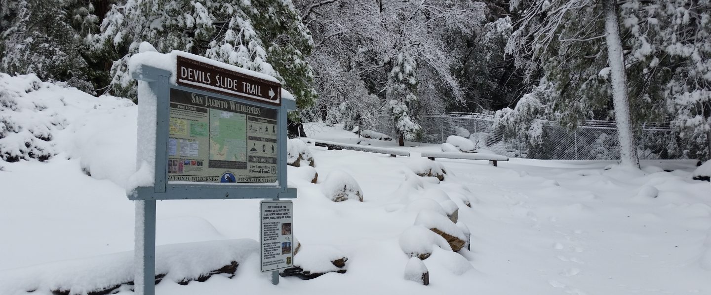
Devil’s Slide Trail is basically clear of snow. Most hikers will not need spikes on the handful of tiny icy snow patches that remain near Saddle Junction.
South Ridge Trail is clear and spikes are no longer required all the way to Tahquitz Peak.
Deer Springs Trail is clear of snow past Strawberry Junction to about 8600′, shortly before the Marion Mountain Trail junction (no spikes required). Snow cover is about 40% from there to the Fuller Ridge Trail junction. Thereafter icy snow cover averages 10% depending on exposure, but it is 50% in Little Round Valley. Above Little Round Valley the icy snow cover is only 5%. Most hikers may find spikes useful, depending upon your comfort level on ice and compacted snow, especially for descending some sections.
The East Ridge Trail between Miller and San Jacinto peaks remains 90% snow-covered, ranging from 1-6″ deep. There are reasonable tracks to follow.
Marion Mountain Trail is almost completely clear of icy snow, however a few tiny, tricky patches remain. Spikes could be useful for descending.
The Pacific Crest Trail at the northern end of the Desert Divide (PCT Miles 172-177) had 43 treefall hazards and three minor landslide hazards (in addition to the major rockslide at Mile 172.5) during my survey on 27th November. It goes without saying that the trail is impassable by stock, and it is relatively slow-going for hikers also. The Trail on the north side of Red Tahquitz (Miles 175-177) remains 80% snow-covered, and spikes are useful. Thankfully there are no treefall hazards on the PCT south from Cedar Spring Trail (Miles 151-162).
Fuller Ridge Trail has cleared completely on sun-exposed slopes, but extensive sections of icy snow remain in several sections. Icy snow cover is especially extensive in the canyon of the North Fork crossing (PCT Mile 186), on heavily forested parts of the ridge crest around Mile 187, and on the north facing slope near the northern end (Miles 189.5-191). There are a couple of reasonable sets of tracks to follow through the snow patches, and spikes are recommended.
The Pacific Crest Trail above Snow Creek (approx. PCT Miles 198-206) was burned on both sides by the Snow Fire (17th-19th September 2020). A closure order for the burn scar means that the Trail remains closed between Snow Creek and Black Mountain Road (PCT Miles 191-206).
Spitler Peak Trail has two new large treefall hazards in the upper switchbacks. The previous dozen downed trees on this trail were removed in early November.
Seven Pines Trail has had no hiker traffic since the last snowfall. Indeed this trail has been hiked very little since November 2018, initially due to snowfall, then the road closure from February 2019. Extremely cautious navigation is recommended for those who are not very familiar with hiking this trail. The Forest Service closure of Dark Canyon Road continues, and there is no vehicular access to Seven Pines trailhead.
San Jacinto Trail Report: available for everyone, funded by readers. While all labor and time is volunteered, this Report completely depends on small private donations to cover its direct costs. In an especially challenging year, and with a busy winter already underway, every contribution is invaluable. If you have found this Report useful, please consider visiting the Donate page. Thank you.
