
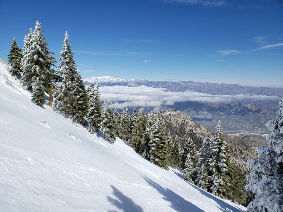
Yesterday I hiked to Castle Rocks on Fuller Ridge. With our continuing road closures, this involved a lengthy hike each way, along a closed section of Highway 243, then up a snowy Black Mountain Road, before using crampons and ice axe to ascend Fuller Ridge. Most of the week was spent hiking trails nearer Idyllwild to check conditions. I recorded the following video from Castle Rocks at about 1140 in the morning yesterday.
Snow conditions are largely unchanged since the previous report on Monday (see that report for detailed snow depth data). Despite very cold conditions, there has been some slow melting at lower elevations, with no significant net change in snow depths. Two days ago it snowed lightly overnight, with an inch in Idyllwild at 5550′, two inches up to 7000′, and three inches above that. This lovely fine powder was sitting on top of very firm, icy snow, a combination which made for easy snow hiking with the right equipment (microspikes to about 8000′, crampons with ice axe higher).
Carrying snowshoes (with poles), crampons (with ice axe), and microspikes, is the unfortunate but ideal gear combination at present, such is the variability of snow conditions due to altitude, aspect, and time of day. PCT hikers may prefer not to carry the weight of snowshoes, accepting that this will result in some serious postholing on warmer days and in the afternoons.
WEATHER After several more days of cold weather including snowfall forecast for tomorrow (with severe cold in the high country), a major shift to settled, sunny weather and above-average temperatures later in the week will result in rapid melting at all elevations.
At Castle Rocks (8600′) on Fuller Ridge yesterday, Saturday 9th March 2019, at 1130 the air temperature was 23°F (-5°C), with a windchill temperature of 7.9°F (-13°C), 80% relative humidity, and an icy 15 mph NW wind gusting to 21 mph.
At San Jacinto Peak (10,810′) on Monday 4th March 2019 at 1025 the air temperature was 34°F (1°C), with a windchill temperature of 17°F (-8°C), 18% relative humidity, and a biting 24 mph WNW wind gusting to 33 mph.
TRAIL CONDITIONS
All trails above about 7500′ remain completely snow-covered, despite rapid melting in the past few days. Details for specific routes are below.
Hikers should be prepared for temperatures below freezing in the high country, and well below freezing above 10,000′ (especially when considering windchill effects).
Microspikes are currently useful mainly in the morning and on well consolidated trails (e.g. Devil’s Slide, lower Deer Springs). Crampons with an ice axe (and solid knowledge of how to use both) are recommended for higher elevations and on moderate angle slopes (e.g. Fuller Ridge, Tahquitz Peak) as the snow consolidates with freeze-thaw cycles, at least in the morning, or all day in colder temperatures. Snowshoes are recommended off-trail above about 8000′, and everywhere at mid elevations after mid-morning on milder days.
Waterproof footwear is useful at least on approach trails (e.g., Devil’s Slide, lower Deer Springs) due to multiple stream crossings and considerable water flowing in the trails. It is also advisable currently due to the slushy quality of the snow on sun-exposed slopes after mid-morning.
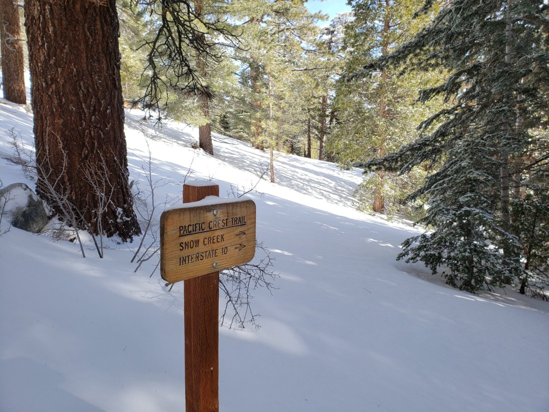
Routefinding remains very challenging for those not familiar with the area. Almost all signage above about 8500′ is snow-covered. Many PCT marker posts are obscured. Very few trails have been broken whatsoever, and tracks from will be at least partly obscured by forecast snow tomorrow.
Pacific Crest Trail Most of the PCT through the San Jacinto mountains has been traversed by only a handful of hikers (or not at all) for weeks, so caution is required for route finding. Patchy snow starts at about Mile 155. By Mile 164, snow depths in places are 1-2 feet. Fuller Ridge Trail is largely a featureless ice slope along almost all its five mile length. Crampons and ice axe are essential. Most PCT hikers should consider the Black Mountain Road alternative.
Black Mountain Road was largely clear of snow by yesterday afternoon for its lower three miles. Up to 7000′ (5 miles up) there was shallow patchy snow. From the Lookout junction to the PCT/Fuller Ridge campground (miles 5 to 8) snow cover is continuous at about 20″ deep. Snow is currently firm and easy to traverse, with or without microspikes.
Devil’s Slide Trail is largely snow-covered to 7500′, then completely under snow thereafter. The trail has been heavily traveled, is obvious, and microspikes are ideal for the consolidated icy snow.
Deer Springs Trail is largely clear to the Suicide Rock trail junction (6900′). From there to Strawberry Junction (8100′) there is about 90% soft snow cover, with many hazardous sections of water flowing under or on the trail route.
Tahquitz Peak trail from Chinquapin Flat is extremely treacherous. Crampons in conjunction with an ice axe, and excellent knowledge of how to use both, are critical.
Ernie Maxwell Trail has about 10% snow cover (1-2″ deep) for most of its length, increasing to about 40% near Humber Park.
South Ridge Road is largely clear of snow in its lower half, but is impassable near the trailhead due to severe road damage. South Ridge Trail is continuously snow-covered ranging from a few inches deep below Old Lookout Flat, to 1-3 feet deep above it. Crampons are very useful on the final approach to Tahquitz Peak (above about 8500′).
Access closures The Valentine’s Day floods continue to make access to the San Jacinto mountains challenging. Palm Springs Aerial Tramway remains closed until approximately 1st April. Highway 243 between Banning and Idyllwild is closed from north of Bay Tree Spring to just north of Alandale until at least April. Highway 74 between Mountain Center and Valle Vista (Hemet) is closed until sometime in March or April. Many minor roads around Idyllwild-Pine Cove remain partly closed or damaged. Apple Canyon Road (access for the Spitler Peak trailhead) is still flooded at Hurkey Creek and closed to non-residents.

One thought on “Snow and trail update 10th March 2019”