
Our hike today went to San Jacinto Peak via Wellman’s Cienega, then descending Deer Springs Trail, which allowed a check of most higher elevation water sources around the mountain. Other hikes this week have included a couple in the Tahquitz area and one up-and-down the Black Mountain Trail. A hike with friends on Thursday 18th October to several peaks above 10,000′ included my 100th ascent of San Jacinto Peak this year.
Weather The moderate precipitation of 12th-13th October is already a distant memory. Temperatures had been pleasantly cool and more-or-less seasonal, but a marked warming to above-average temperatures starting today will continue over the next few days, before a return to cooler weather early next week.
Other than during the unseasonably warm weather for about the next week, hikers should now expect temperatures near freezing in the high country >9,000′ elevation, and at or below freezing at the high peaks (potentially well below freezing with windchill).
At San Jacinto Peak at 0925 this morning, Thursday 25th October, the air temperature was 45°F (7°C), with a windchill temperature of 40.4F (5°C), 32% relative humidity, and a very light mph North wind gusting to 5 mph. Note that the windchill temperature was 45° warmer than at the same time ten days earlier!
On Thursday 18th October at 0730, the air temperature was 27°F (-3°C), with a windchill temperature of 9.4°F (-12.5°C), 62% relative humidity, and a bitter 21 mph NNE wind gusting to 24 mph.

Trail overview The modest rainfall throughout the mountain – with even a dusting of snow in the high country – nearly two weeks ago has had no lasting impact on the water situation in the San Jacinto mountains, which remains very poor. The overall status of water sources is basically unchanged from early October. Miniscule patches of snow remain on San Jacinto Peak near the East Ridge Trail, but some decent patches (1-2″ deep) remain in Snow Creek on the uppermost North Face.
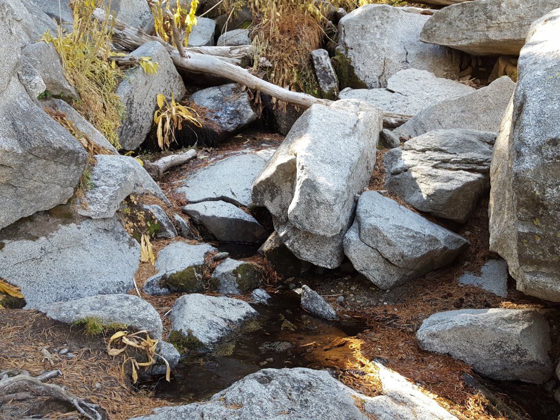
Cedar Spring on the Desert Divide just to the east of the PCT continues to flow gently, as detailed in a prior report at this link.
Excellent news on the Seven Pines Trail, as first reported here last week. It seems that frequent reporting of the poor condition of this trail to the agencies paid off, and the several dozen trees that were across this lovely trail have been largely cleared by a State maintenance team.
EASTERN SLOPE WATER FEATURES
The Round Valley faucet has been dry since the summer.
Both the northern and southern springs at Wellman’s Cienega continue to flow gently.

These springs are the sources for Willow Creek, which is no longer flowing where it crosses the Willow Creek Trail. There are small pools where water could be filtered just upstream from the crossing. The creek is actually flowing gently a few hundred yards upstream from the trail crossing, but access is not easy. Willow Creek has not previously been known to stop flowing at the trail crossing.
Tahquitz Valley has been completely dry since May.
Tahquitz Creek continues to flow well at the northern (lower) end of Little Tahquitz Meadow. This is the last remaining “reliable” water source in the Tahquitz meadows area.

Tahquitz Creek is barely trickling further upstream at its source (known locally as Grethe Spring) where it crosses the PCT at the northern end of the fire closure (approx. PCT Mile 177). Immediately after (barely) crossing the PCT, the creek dries up.
Skunk Cabbage Creek is dry where the trail crosses Skunk Cabbage Meadow at the small wooden bridge.
WESTERN SLOPE WATER FEATURES
The North Fork of the San Jacinto River continues to flow poorly where it crosses the Deer Springs Trail. Flow rate was down to about 0.5 gallons per minute today. Flow of this major west-side water source this year has been the lowest in known history.
Just downstream, the North Fork of the San Jacinto River was still dry today where it crosses the Pacific Crest Trail on Fuller Ridge (approx. PCT Mile 186). This was the critical water source for PCTers and others hiking to or from Snow Creek, a 22 mile section of trail infamous for being waterless (but now waterless for >25 miles). Options for southbound PCT hikers (and other hikers on this section) are all poor. Switchback Spring and Strawberry Cienega (see below) are possibilities staying on the PCT, but both are at extremely low flows. If heading to San Jacinto Peak, the North Fork where it crosses the Deer Springs Trail is a good option. Alternatively, from where the PCT crosses the Black Mountain Road it is possible to descend the road 2.4 miles to the Cinco Poses Spring (a faucet by the roadside, see below). This undulating and exposed road is a descent of about 600′ and ascent of 200′, that would have to be reversed on the way back. PCT hikers who choose to leave the PCT to ascend San Jacinto Peak quickly get access to water at the North Fork on Deer Springs Trail (as described above) and subsequently at Wellman’s Cienega (assuming they choose to descend via the east side).
O’Sullivan Creek (PCT Mile 186.3) on Fuller Ridge Trail has been dry since early May.
The spring in the creek in Little Round Valley has been completely dry since early June.
Shooting Star Spring – 0.28 trail miles below Little Round Valley – continues to flow very gently. For hikers it is just possible to filter water from the source at the base of the obvious huge rock at the top of the wet area of trail, but a better option is to descend to the North Fork crossing mentioned above.
The Deer Springs stream crossing at the PCT (approx. PCT mile 185.6) is dry, and the pools just upstream (and downstream) of the trail are also dry. The Deer Springs themselves continue to flow gently, about 0.15 miles upslope from the trail. Unfortunately, almost all the flow is diverted into a pipe for the Deer Springs camp. The Deer Springs camp just downslope from the trail has been occupied by a crew from the California Conservation Corps off-and-on since late May.
Switchback Spring – the small spring just below the eight switchbacks on Deer Springs Trail about 0.4 miles north of Strawberry Junction – continues to trickle gently, although flow was very weak today. The tiny pool on the upslope side of the trail is now so shallow that filtering is very challenging.

The little spring at Strawberry Cienega (PCT mile 183) is dry. The tiny pool in the crack between the two large rocks might be useable for emergency filtering.
Cinco Poses Spring on Black Mountain Road (4.7 miles up from Highway 243) still has abundant water at the faucet. Please do not forget to completely turn off the faucet when you are finished here. This could be an important emergency water source as others dry up throughout the western side of the mountain. [Many thanks to Florian Boyd for this update from our joint shift at the Black Mountain fire lookout on Tuesday 23rd October.]
On Devil’s Slide Trail, Middle Spring has been dry since 26th July.
On the Ernie Maxwell Trail, Chinquapin Creek just below Humber Park has been periodically diverted by Fern Valley Water District since the summer. It was dry where it crosses the trail when I checked it on Monday 22nd October. Even when the creek is diverted, good pools receive some fresh flow immediately upstream from the trail. This is a very important water source for the many dogs walked on this trail.
