[UPDATE 1st December 2022: the double storm system that looks likely to bring significant precipitation to northern and central California appears to be missing the San Jacinto mountains, despite optimistic forecasts over the previous week. Three periods of cold, cloudy days are now expected over the next ten days, but little if any precipitation.]
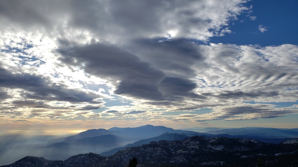
The storm expected on 28th November failed to materialize, producing only below average temperatures, wind, and spectacular clouds (photos below). A second forecast storm system may bring some light precipitation to the San Jacinto mountains on 2nd December, and possibly again on 4th-5th.
Current trail conditions are oddly reminiscent of spring, with snow distribution and iciness feeling more typical for April or May than late November. Snow from the moderate storm on 8th-9th November (summarized here) has been melting steadily at mid elevations but more slowly in the high country given the relative weakness of the sun at this time of year.
We have surveyed the high country almost daily, with hikes taking in San Jacinto Peak at least twice per week, Tahquitz Peak area once per week, and a variety of other trails on other days (World Cup viewing permitting of course). On 24th and 28th we barebooted to the Peak on well-traveled and compacted tracks through light icy snow. Both days I put spikes on at the Peak for the descent, on 24th keeping them on until about 8000 ft on Marion Mountain Trail, and on 28th until about 9900 ft on the Peak Trail, roughly one mile north of Wellman Divide.
Trails remain very icy due to daily freeze/thaw cycles and compaction from hiker traffic, so spikes are recommended throughout the trail system above about 8000 ft (lower in places). Spikes are especially valuable for descending even when they are no necessarily needed for ascending. Given colder temperatures for the foreseeable future, melting is expected to slow (or almost stop in the high country) and spikes will remain recommended well into December at least.
Snowshoes are not required anywhere on the established trail system, where snow is now too shallow, icy and compacted. In my recent experience off-trail snow is now also largely too shallow and/or patchy for snowshoes.
Snow depths measured at various locations on the trail system are given at the foot of this posting. Note however that snow depth is rarely indicative of the challenge (or otherwise) of a given trail. Although excellent tracks are now in place for almost all major trails cautious navigation remains recommended.
Hikers should be prepared for temperatures near or below freezing in the high country, and generally well below freezing when considering wind chill effects (see below for my recent weather observations from San Jacinto Peak).
Dark Canyon Road (4S02, the access to Seven Pines Trail) and Santa Rosa Truck Trail (7S02) closed to vehicle traffic for the season on 7th November 2022. Black Mountain Road also closed on 7th November to vehicle traffic at the gate 1.7 miles up from Highway 243. Forest Service campgrounds at Boulder Basin, Marion Mountain, and Fern Basin are closed for the season. Stone Creek campground had also closed, but I saw that it had apparently reopened for Thanksgiving weekend.

WEATHER
Temperatures will be near or generally below seasonal for the next ten days at least. A weather system, possibly in two waves across a broad time window between 2nd and 5th December, is currently forecast to produce light precipitation at all elevations, including a possible dusting of snow in the high country [update 1st December: no precipitation is now expected from these storms passing to the north of us]. The highest probability of precipitation is early morning on Friday 2nd. Precipitation on Sunday 4th into the early hours of Monday 5th is significantly less likely in the latest models. Temperatures may be mild enough to produce rain at mid elevations, for example totaling less than 0.25 inch in Idyllwild, while snow accumulation above 10,000 ft elevation is currently forecast to be a dusting, perhaps few inches at most.
At San Jacinto Peak (10,810ft/3295m) on Monday 28th November 2022 at 0855 the air temperature was 26.2°F (-3°C), with a windchill temperature of 8.8°F (-13°C), 11% relative humidity, and a sharp due West wind sustained at 17 mph gusting to 24.6 mph.
At the Peak on Thursday 24th November 2022 at 0810 the air temperature was 29.0°F (-2°C), with a windchill temperature of 5.7°F (-15°C), 16% relative humidity, and a severe NNW wind sustained at 25 mph gusting to 35.1 mph.
TRAIL CONDITIONS
Trails above about 7500 ft currently remain lightly covered with patchy icy snow (more continuous above about 9000 ft). However excellent well-traveled and compacted tracks are now in place for almost all major trails (details below).
Hikers will encounter new treefall hazards due to the enormous weight of ice from freezing rain associated with the early November storm, followed by recent Santa Ana winds, and since the passage of Tropical Storm Kay in September. New treefall hazards on major trails have been reported to relevant agencies, and those on Spitler Peak Trail have already been cleared by the Trail Report.
The Ernie Maxwell Trail is functionally clear of icy snow, although a few minor patches remain, especially close to Humber Park. Spikes are not required. One major treefall hazard is across the trail almost exactly midway between the trailheads at Humber Park and Tahquitz View Drive.
Devil’s Slide Trail is functionally clear of icy snow to about 7700 ft (about 1.7 miles up) although some dirty icy patches remain below that. Spikes not required to that elevation. Above that elevation, icy snow cover is about 60% to Saddle Junction. Spikes are generally not required for ascending, but most hikers find them useful at least for descending.
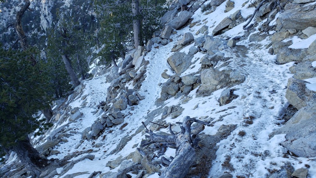
There is a very well-traveled track from Saddle Junction to Tahquitz Peak. The 0.4 mile section of South Ridge Trail between Chinquapin Flat/PCT and Tahquitz Peak has a well-traveled and level track to follow through the slowly melting inch of patchy icy snow (photo below from 30th). Although not required, many hikers will find spikes useful especially for descending.
The PCT on the south-facing slope (“Angel’s Glide”) for about 1.0 mile north of Saddle Junction is largely clear of snow (spikes not required).
The Wellman Trail from Annie’s Junction to Wellman Divide has about 40% icy snow cover. Some hikers will find spikes are useful at least for descending.
The Peak Trail has about 90% cover of icy snow to 9900 ft elevation, and then >95% cover to San Jacinto Peak. Spikes are recommended.
The East Ridge Trail (from near Miller Peak to San Jacinto Peak) has a handful of tracks through the continuous snow, though none (including mine) accurately follow the trail route. Snow on this east slope is drifted, and remains up to 12 inches deep in places.
There is a well-traveled track on light icy snow from Long Valley/Tram to Wellman Divide. Skyline Trail has a good track to follow through increasingly patchy, very thin, icy snow above about 7000 ft (the Traverse to Grubb’s Notch). Spikes are recommended but not required depending upon your comfort level hiking on angled icy snow.
South Ridge Trail (surveyed 26th and 30th November) is now functionally clear of snow to Tahquitz Peak with only 1-2% icy snow cover overall. Some hikers may continue to find spikes useful for some of the minor icy patches but they are no longer required. South Ridge Road is now clear of ice and snow.
Marion Mountain Trail (surveyed at least weekly in past month) has a very well-defined track to follow. Icy snow cover is 60% overall, becoming increasingly patchy below about 7000 ft, and again in the sun-exposed areas above 8000 ft. Spikes are useful, especially for descending.
Deer Springs Trail is clear from the Highway 243 trailhead to the Suicide Rock trail junction at 7000 ft, and functionally clear from there to Strawberry Junction (8100 ft), with a few icy snow patches increasing in length and frequency as you ascend. Snow cover is about 60% from Strawberry Junction north for about 1.0 mile (roughly 8500 ft), and thereafter >90% to San Jacinto Peak. An excellent track is easy to follow to Little Round Valley. Above Little Round Valley there are at least half-a-dozen tracks ascending toward San Jacinto Peak, none of which entirely accurately follow the established trail route. The main track is clearest just above LRV and again close to the Peak junction. Spikes are recommended at least for descending upper Deer Springs Trail.
Spitler Peak Trail (last surveyed 18th November) is clear of snow. Given the importance of this trail for the safety of northbound PCT hikers in particular, it is one of several trails “adopted” by the Trail Report. We removed nine treefall hazards on 18th November and the trail is now completely clear again, bringing to 56 the number of trees we have removed from this trail since mid 2021.
Willow Creek Trail remains a relatively slow, messy hike for a couple of miles. Some 37 trees are down on the Forest Service section of this trail between Skunk Cabbage Junction and the State Park boundary (23rd September 2022 survey). Of those, 27 are in the 0.6 mile section between Willow Creek crossing and the State Park boundary. A few trees were cut by chainsaw at the far (Hidden Divide) end of the Forest Service section recently, presumably by a CCC or State Park crew. The State Park cut about a dozen trees on the section of trail under their jurisdiction in late July. Another tree came down near the start of this trail close to Saddle Junction in Tropical Storm Kay.
Although some treefall hazards from Red Tahquitz to Antsell Rock (PCT Miles 172.5-175) were cleared in June 2021 prior to the rockslide removal work, the situation has badly deteriorated since. In my most recent survey there were at least 82 treefall hazards between PCT Miles 170-175 including 20+ major ones, and about six more on PCT Miles 175-177. PCTA is aware of the situation, and is hoping to start addressing it soon (weather permitting).
On Fuller Ridge Trail there are five major treefall hazards obstructing the trail in the 1.5 mile section nearest to the campground (PCT Miles 189-190.5). Although most of the downed trees reported this summer were cleared in July, four more major trees came down in Tropical Storm Kay in September.
The Caramba Trail from near Reeds Meadow through Laws Camp and on to Caramba, and the Cedar Trail from Willow Creek Trail to Laws, are described by the Forest Service as “not maintained”. This is frankly grossly misleading and in reality both trails no longer exist and are so completely overgrown I strongly advise hikers do not attempt to follow them. An informal use trail to Laws is much more direct and avoids all of the very challenging bushwhacking of the former trails (local hikers Charles Phelan and Mark Gumprecht kindly nicknamed it the “King Trail” when I established the route in 2019). It leaves the Willow Creek Trail exactly 1.0 mile from Saddle Junction (0.46 mile from the Skunk Cabbage turning), descending largely on established deer trails for 1.2 miles, meeting Willow Creek just upstream from the old Laws Camp. From Laws east to Caramba the route of the original Caramba Trail has been well-cairned by myself and others and can largely be followed with very careful route-finding. My 2022 survey counted 97 trees down on this 2.1 miles of trail. It is especially obscure 0.1-0.3 mile east of the Willow Creek crossing, becoming more obvious near Caramba. Very cautious navigation is advised throughout the area.
Seven Pines Trail has one set of hiker tracks through the snow since the storm in early November 2022. This trail has had limited hiker traffic since November 2018, largely because Dark Canyon Road has only been open for a few months since February 2019. The Trail Report has “adopted” Seven Pines Trail as a priority for maintenance work as the trail has had a disproportionate number of lost hiker rescues in the past decade. Between November 2021 and May 2022, 61 downed trees were removed and almost the entire trail thoroughly trimmed and cleared. Remarkably Tropical Storm Kay did not add any new treefall hazards to this trail. Nevertheless Seven Pines remains a genuine wilderness trail unlike the relatively wide, bare, and obvious routes of, for example, Devil’s Slide or Marion Mountain trails. Cautious navigation remains required for those who do not have significant experience of hiking this trail.
SNOW DEPTHS measured on or around 28th November 2022 are as follows, with depths after the last significant storm (on 9th November) for comparison in parentheses where known. Note that average depth is given; due to strong winds there has been extensive drifting, often particularly accumulating in the trails. Conversely in places scouring by the wind means the depths are well below the average. Altitudes are approximate.
San Jacinto Peak (10810 ft): 4-5 inches (was 12 inches on 9th)
Little Round Valley (9800 ft): 4 inches on 24th (was approx. 10 inches on 9th)
Wellman Divide (9700 ft): 0-1 inch (was 4 inches on 9th)
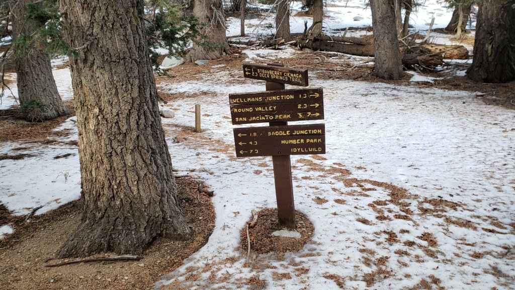
Annie’s Junction/approx. PCT Mile 181.8 (9070 ft): 0-1 inch, photo below (was 6 inches on 9th)
Deer Springs Trail at top of Marion Mountain Trail (8700 ft): 1-2 inches
Tahquitz Peak (north side trail, 8700 ft): 0-1 inch [measured 26th November]
Tahquitz Peak (south side trail, 8500-8700 ft): 0 inch [measured 26th November]
Long Valley (8600 ft): <1 inch (was 2-3 inches on 9th)
Strawberry Junction (8100 ft): 0 inch (was approx. 2-3 inches on 9th)
Saddle Junction/approx. PCT Mile 179.9 (8070 ft): <1 inch (was 3 inches on 9th)
Devil’s Slide Trail at Humber Park (6550 ft): 0 inch (was 2.5 inches on 9th)
Idyllwild (at 5550 ft): 0 inch (was <1 inch on 9th)
While all time and labor is volunteered, the San Jacinto Trail Report uses small private donations to cover costs. Every year seems to have unique challenges and 2022 has been no exception. Your contribution keeps the Report available to all, free from advertising or paywalls, and independent from agencies. If you have found this Report useful, please consider using this link to the Donate page. Zelle, Venmo, and PayPal are all options. Thank you so much for your support.


Thank you for producing this accurate and much appreciated report! Do you happen to know anything about the status of the “Zen Center” trail that connects to the PCT? Jane
>
LikeLike
Thank you Jane. I hike the Zen Center Trail regularly. It is in poor and deteriorating condition (and has been ever since the July 2013 Mountain Fire). It is very overgrown and has several treefall hazards, making it hard to follow even for those who know it well. If you are fine with a rugged trail and a bit of a navigation challenge, it is a very useful shortcut. Safe hiking, Jon.
LikeLike