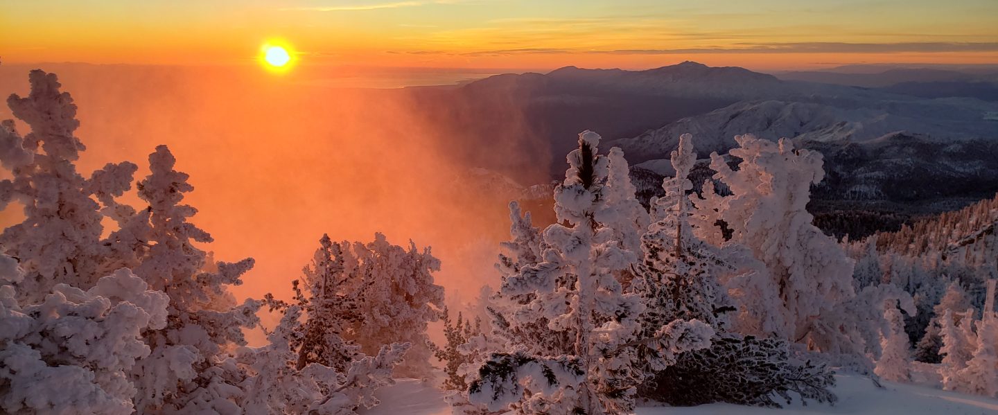
I have continued to hike daily to San Jacinto Peak since 1st May, making today 41 consecutive ascents. The past few days have been delightfully cool, and I recorded windchill temperatures of 18°F (-8°C) at San Jacinto Peak on both Saturday 6th and Sunday 7th. We took advantage of the cool weather on both 8th and 10th June to hike a circuitous route via Willow Creek Trail, Hidden Divide, and Round Valley to the Peak.
It is that time of year when the Trail Report is brief. Snow is now completely gone from the trail system, and water is, for now, flowing steadily everywhere. My focus has been on trail maintenance work and surveying for future projects.
Limited camping is now available in Mount San Jacinto State Park. See their website for details. The U.S. Forest Service ranger station remains closed, although faxed requests for camping permits are being processed promptly. There is a tentative reopening date of 18th June for USFS operations.
The closure of Black Mountain Road has been extended to 1st July, per the Forest Service order issued last week. Grading work may be finished sooner. Palm Springs Aerial Tramway is closed indefinitely (since 12th March) due to the coronavirus crisis.
WEATHER Temperatures will be slightly above seasonal – especially the overnight lows – for the next ten days, averaging coolest this weekend (13th-14th June). There is no precipitation in the forecast.
At San Jacinto Peak (3295m/10,810ft) today, Wednesday 10th June 2020, at 0815 the air temperature was 50.4°F (10°C), with a windchill of 47.3°F (8.5°C), 33% relative humidity, and a very light ESE wind sustained at 1.0 mph gusting to 4.8 mph.
The coolest recent day at the Peak was Sunday 7th June 2020, when at 0720 the air temperature was 34.0°F (1°C), with a windchill of 18.1°F (-8°C), 22% relative humidity, and a brisk WNW wind sustained at 18 mph gusting to 29.0 mph.
The warmest day of 2020 to date recorded at San Jacinto Peak was Thursday 28th May, when at 0830 the air temperature was 54.9°F (13°C).
TRAIL CONDITIONS
All trails are clear of snow. Off-trail travel will still encounter minor drifts, e.g., on the north side of Jean Peak.
Many trails have new treefall hazards from this past winter, passable for hikers but not for stock. Some are described in detail below, others include: PCT south of Red Tahquitz (approx. PCT Miles 173-175), PCT between Strawberry Cienega and Deer Springs camp (Miles 182-185), Spitler Peak, Cedar Spring, and Apache Spring trails.
Willow Creek Trail has 19 tree hazards (8 on Forest Service land, 11 on State Park) between Willow Creek and Hidden Divide from this past winter, based on new surveys on 8th and 11th June. Five additional trees on Forest Service land between Saddle Junction and Willow Creek have been cleared since late May. Great progress has been made on whitethorn removal, with the trail now cleared on the State Park side and only a few more weeks work needed on the Forest Service section.
Seven Pines Trail has been very lightly traveled since November 2018. There are 25 treefall hazards on the trail, based on multiple May/June 2020 surveys. Very cautious navigation is recommended for those unfamiliar with this trail. The Forest Service closure of Dark Canyon Road is expected to continue into 2021, so there is currently no vehicular access to Seven Pines trailhead.
Forest Service temporary signage indicates that the Caramba Trail from near Reeds Meadow through Laws Camp and on to Caramba, and the Cedar Trail from Willow Creek Trail to Laws, are “not maintained”. In reality both trails no longer exist. Both are so heavily overgrown I advise hikers do not attempt to follow them. Many experienced hikers have reported getting lost in this area since summer 2019. An informal use trail to Laws has been developed which is much more direct and avoids all of the challenging bush-whacking of the unmaintained trails (some local hikers have kindly named it the “King Trail”). It leaves the Willow Creek Trail exactly 1.0 mile from Saddle Junction (0.46 mile from the Skunk Cabbage turning), descending largely on established deer trails for 1.2 miles, roughly paralleling Willow Creek just to its south. Currently it is indistinct, becoming even less obvious as it nears Laws (by which time Willow Creek is close by on your left hand side, so navigation is not a challenge). I hope to work on the trail in July. From Laws east to Caramba the route of the original Caramba Trail is relatively easy to follow (for those who were familiar with this trail prior to the 2013 Mountain Fire). Nevertheless very cautious navigation is still advised.
The Pacific Crest Trail remains open at the rockslide just north of Antsell Rock (Mile 172.5). USFS has not indicated when this area may close for removal of the rockslide. The video report (available here) can be useful for deciding whether to hike around the rockslide or take an alternate route.
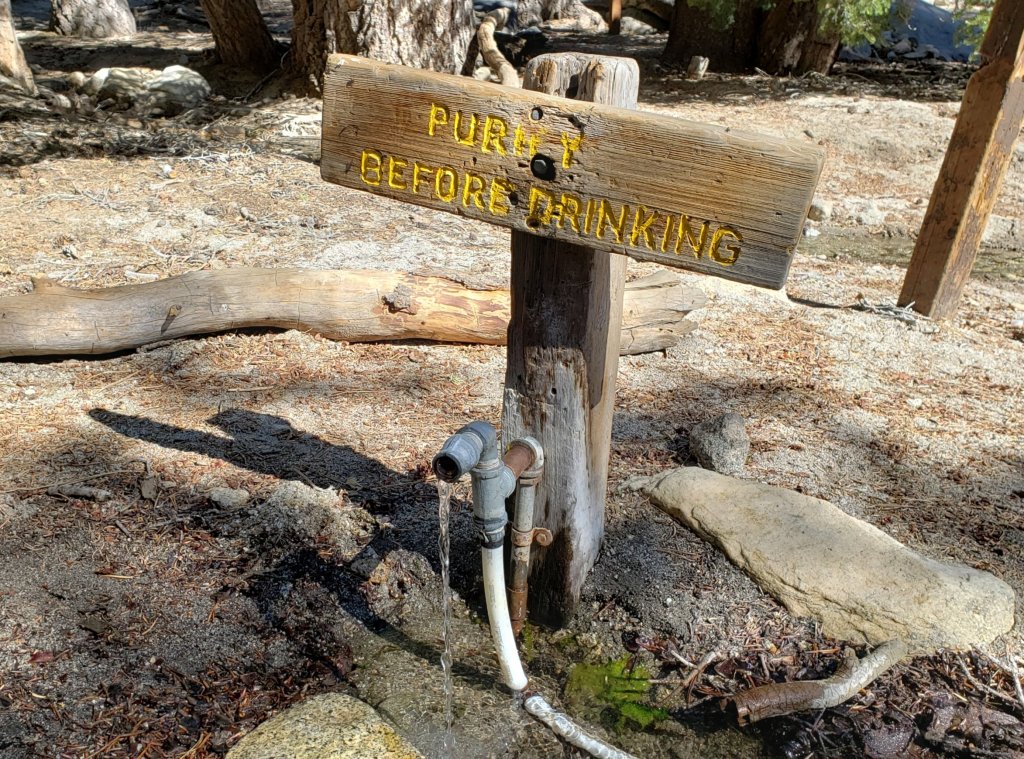
WATER All major creeks and springs are currently flowing well, as are some ephemeral sources. Consequently their status is not being updated in detail at this time. Flow rates have dropped dramatically in recent weeks, some 2-3 months earlier than last year, and some water challenges in late summer and autumn seem likely.
San Jacinto Trail Report: available for everyone, funded by readers.While all labor and time is volunteered, this Report completely depends on small private donations to cover its direct costs. With a very challenging first few months of 2020, every contribution is invaluable. If you have found this Report useful, please consider visiting the Donate page. Thank you.
