
[UPDATED 3rd April 2020: a new discussion of the major snow storm expected next week, and some suggestions for PCT hikers to safely deal with the conditions, is available on YouTube. I have also updated some trail information below based on recent hikes.]
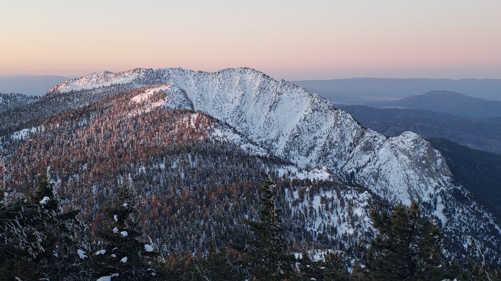
We hiked to the Apache Peak area this morning to assess conditions there (discussed below and in the short video available here), and to San Jacinto Peak two of the previous three days. A very light snow storm on Sunday night produced a barely measurable 0.25″ of graupel everywhere above 7000′, which briefly greatly helped traction early yesterday morning.
Otherwise, a cool and very unsettled March is giving way to a warmer April, and it has felt like the snow conditions have almost been changing by the hour on recent hikes. Icy, reliable snow in the early morning can turn to the consistency of warm ice cream by late morning in many areas, depending on exposure, temperature, and cloud cover, which can help or hinder hiking depending on your preference.
Snow depths measured yesterday are listed at the foot of this posting. There has been little hiker traffic in the high country, so cautious navigation is recommended everywhere, although most major trails, including the entire PCT, have reliable tracks to follow through the snow.
Equipment recommendations are changing almost as quickly as the snow conditions. Microspikes remain useful in some areas (see below) for hikers who are less comfortable on snow and ice, on compacted well-traveled trails, and in particular for descending. Hikers with suitable footwear and hiking poles will often not need any additional traction, depending on temperature as discussed above. Shallow snow depths largely preclude any use for snowshoes now, except perhaps in some areas off-trail above about 9500′ elevation, and on the western side in and above Little Round Valley.
Hikers should be prepared for temperatures near or below freezing in the high country, and potentially well below freezing when considering windchill effects.
Due to the Covid-19 crisis, the Palm Springs Aerial Tramway remains closed indefinitely since 12th March (currently until at least 30th April).
The USFS gate at Humber Park has been closed since 18th March. There are nine legal parking spaces (available for all uses) just below the gate and near the upper Ernie Maxwell trailhead. The next closest legal parking is 0.1 mile downhill on Forest Drive.
WEATHER Warmer – but still below average – temperatures are forecast for the first few days of April, followed by a return to cold weather with a moderate storm system around Monday 6th April, potentially lasting several days. Melting will continue to be rapid this week, especially on sun-exposed slopes and below 9000′ elevation.
At San Jacinto Peak (10,810ft/3295m) yesterday, Monday 30th March 2020, at 0950 the air temperature was 31.2°F (-0.5°C), with a windchill of 21.0°F (-6°C), 39% relative humidity, and a light NNW wind sustained at 4 mph gusting to 9.7 mph.
At the Peak on Saturday 28th March 2020, at 0910 the air temperature was 21.4°F (-6°C), with a windchill of 8.2°F (-13°C), 41% relative humidity, and a fresh due W wind sustained at 8 mph gusting to 11.4 mph.
PACIFIC CREST TRAIL
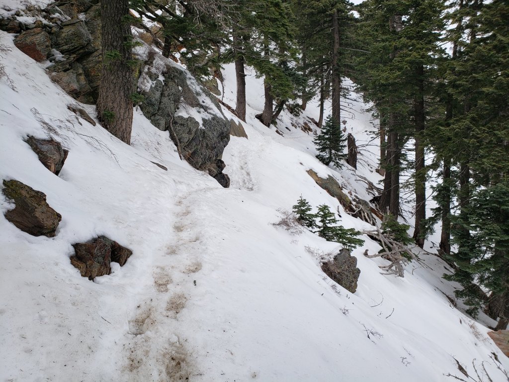
The short icy snow slope on the NE side of Apache Peak (PCT Mile 169.5) that had multiple incidents a few days ago has greatly improved. This morning snow was relatively soft, and steps were large, flat, and well-formed. Most hikers passing through were using spikes, but it was possible to traverse without them securely. Every individual should make their own assessment of whether to cross based on their comfort level on angled snow, their experience, available equipment, time of day, and current snow conditions. If in any doubt, turn around and take the Spitler Peak Trail alternate option at Mile 168.5.
The Pacific Crest Trail remains open at the rockslide just north of Antsell Rock (Mile 172.5). USFS has told the Trail Report that there are currently no plans to close this section of the PCT during spring 2020. The video report (available here) can be useful for deciding whether to try to hike around the rockslide or take an alternate route. All hikers this spring are reporting having no significant difficulty here.
Microspikes may be useful on some of the PCT for patchy snow travel between approximately Miles 160 and 192, depending upon your comfort level in variable snow/ice conditions. Many thru-hikers using poles will probably find spikes unnecessary in most areas however. See below for conditions on some specific sections of the PCT and the many side trails.
Current snow cover on the PCT is patchy and thin between Miles 160 and about 175 (Red Tahquitz), mainly confined to certain north-facing slopes e.g., Spitler Peak (Mile 168) and Apache Peak (Mile 169.5). Snow is then continuous between Miles 175-179 (to near Saddle Junction). The Trail is then clear in large patches to about Mile 184, except for a stubborn section of 0.5 mile approaching Annie’s Junction (Mile 180.8) which is always among the last areas to clear every spring. Most of Miles 184-191 is snow-covered, although some exposed sections of Fuller Ridge (e.g., Miles 186.5-188.5) are starting to clear rapidly. North from about Mile 191 to Snow Creek is clear.
PCT hikers are reminded that overnight stays are not permitted at or near San Jacinto Peak, including in the historic shelter. Mt. San Jacinto State Park regulations normally permit overnight stays only in established campgrounds, although due to the Covid-19 crisis, no camping is currently allowed anywhere in the State Park.

TRAIL CONDITIONS
All trails above about 8000′ remain largely snow-covered, with depth depending on elevation (see below) but exposed slopes much higher are clearing rapidly (e.g., around Wellman’s Cienega). Some sections of trails above about 7000′ have patchy icy snow cover, depending on exposure.
Deer Springs Trail is largely clear of snow to Strawberry Junction with just a few patches close to the junction (microspikes not required). The PCT section from here to Fuller Ridge is partly clear of snow to about 8500′ elevation (south of the Marion Mountain Trail junction), then there is extensive snow cover thereafter, currently with an adequate track to follow. From Little Round Valley to San Jacinto Peak there may be drifting in places after strong winds. Snowshoes may be useful above about 9500′ and microspikes can be useful for descending.
South Ridge Trail [updated 4th April] is completely clear to Old Lookout Flat at 7600′. Snow cover is patchy (<20%) higher up, and the small patches are easily hiked. Microspikes may be useful but are not required. South Ridge Road is clear of ice.
Fuller Ridge Trail (PCT Miles 185.5-190.5) has been clearing, especially on sun-exposed slopes, mainly Miles 186.5-188.5. There are tracks to follow through the snow, although these do match the route of the regular trail in places.
Round Valley Trail through to Wellman Divide has not been visibly traveled since the Tram closure in mid March.
Devil’s Slide Trail is largely clear of snow below 7700′. Icy snow cover is about 50% from there to Saddle Junction. Microspikes can be useful mainly above 7600′, especially for descending, but are not essential.
Ernie Maxwell Trail is virtually clear of snow, with just a few tiny patches, mainly near Humber Park.
Tahquitz Peak trail from Chinquapin Flat/PCT Mile 178 has no steps to follow through the angled icy snow for at least 0.3 miles. These ice slopes are notoriously treacherous. Crampons are strongly recommended, in conjunction with an ice axe (if you know how to use both). Snowshoes are not advised due to the angle of the underlying ice.
Seven Pines Trail has had no hiker traffic so far this winter, with no tracks or trail to follow. Indeed this trail has only been hiked a handful of times since November 2018. Extremely cautious navigation is recommended for those who are not very familiar with hiking this trail. The Forest Service closure of Dark Canyon Road continues, and there is no vehicular access to Seven Pines trailhead.
SNOW DEPTHS measured on 3rd April 2020 (with depth on 31st March 2020 in parentheses). Note that average depth is given, drifts can be much deeper in places. Altitudes are approximate.
San Jacinto Peak (10810′): 22″ (27″)
Wellman Divide (9700′): 8″ (12″)
Annie’s Junction (9070′): 16″ (18″)
Long Valley (8600′): 3″ (6″)
Strawberry Junction (8100′): 0″ (1″)
Saddle Junction (8070′): 4″ (7″)
Devil’s Slide trailhead at Humber Park (6550′): 0″ (0″)

