Trail update 1st July 2021

Daily hikes have included San Jacinto Peak multiple times per week by a variety of routes, plus in recent days South Ridge Trail, Laws/Caramba area, South Fork Wilderness Trail, and the Tahquitz/Skunk Cabbage meadow trail complex.

Recently I have focused on vegetation trimming along several major trail sections, notably South Ridge Trail, upper Deer Springs Trail, the “Strawberry Trail” (PCT from Annie’s Junction to Strawberry Junction, Miles 181-183), Spitler Peak Trail, and the South Fork Wilderness Trail, the latter with the help of Forest Service volunteer Bill Rhoads.

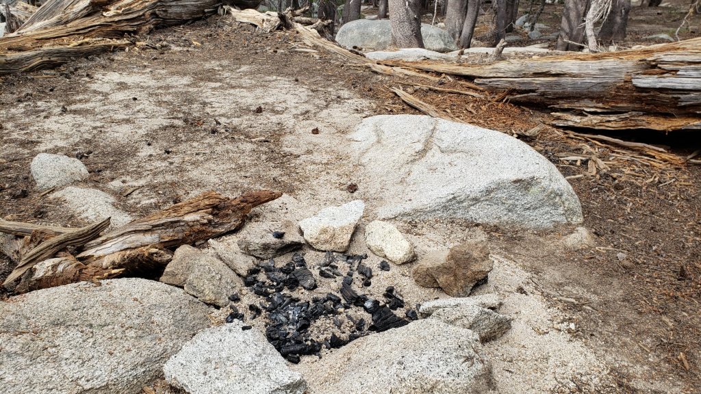
Full fire restrictions began on Wednesday 23rd June on Forest Service lands, as described here. All campfires at USFS campgrounds and yellow post sites in the San Jacinto mountains are now prohibited.

Relatively cool, cloudy weather with minor precipitation (0.02in in Idyllwild at 5550ft) was a pleasant relief last week on 23rd and 24th June. Temperatures for the foreseeable future will be above seasonal averages, so plan your hiking accordingly for hot, dry conditions.

Hikers should also be prepared for rapidly changing weather conditions in the high country in summer. Monsoon conditions, usually in the afternoons, are a slim possibility for the foreseeable future. Thunderstorms with lightning, precipitation, and rapid temperature drops, can occur in the high country even when such storms are not forecast for lower elevations.

Water conditions in the high country continue to deteriorate. Recent hot, dry weather has not helped the situation. The current status of many key springs and creeks is described in detail in the previous Report.

The rockslide at PCT Mile 172.5, just north of Antsell Rock, was removed on Monday 14th June. My “before, during, and after” video is available here, and has been surprisingly popular (likely because it is short and stuff blows up!). The project was a success, making this section of the PCT significantly safer, and it is now readily passable with care by hikers (but it remains impassable for stock).

The U.S. Forest Service ranger station in Idyllwild remains closed due to USFS coronavirus protocols. It is not expected to reopen before late July. Hiking and camping permits are nevertheless required for USFS lands, and are usually available at the kiosk outside the ranger station. The State Park ranger station reopened months ago.

WEATHER Temperatures overall will be at or above seasonal averages for the foreseeable future, with overnight lows in particular tending to be well above seasonal. There is no significant precipitation in the forecast. Fire risk remains severe.

At San Jacinto Peak (10,810ft/3295m) on Thursday 1st July 2021 at 0805 the air temperature was 52.3°F (11°C), with a windchill temperature of 47.6°F (9°C), 48% relative humidity, and a light due West wind sustained at 5 mph gusting to 9.0 mph.

At the Peak on Monday 28th June 2021 at 0655 the air temperature was 58.8°F (15°C), with a windchill temperature of 54.7°F (13°C), 43% relative humidity, and a light due North wind sustained at 5 mph gusting to 8.4 mph.

At the Peak on Thursday 24th June 2021 at 0755 the air temperature was 44.0°F (6°C), with a windchill temperature of 34.7°F (2°C), 96% relative humidity, and a fresh SSW wind sustained at 12 mph gusting to 17.3 mph.

South Fork of the San Jacinto River at 3650ft elevation where it intersects the South Fork Wilderness Trail, 25th June 2021. The riverbed was altered dramatically by the great flood event of 14th February 2019.

TRAIL CONDITIONS

Trails throughout the San Jacinto high country cleared of snow by early May. Water conditions are a major concern, with most springs and creeks already having flows more typical of late autumn. Conditions have not changed significantly since the previous Report.

Black Mountain Road reopened on 23rd April, and the Black Mountain Fire Lookout on 23rd May. Boulder Basin campground reopened on 22nd May along with other USFS seasonal campgrounds. Tahquitz Peak Fire Lookout reopened for the season on Sunday 30th May.

Many trails have accumulated treefall hazards from the past two winters, passable with care by hikers but not for stock. Some are described below, others include: PCT between Strawberry Cienega and Deer Springs camp (PCT Miles 182-185, about 12 trees down), Fuller Ridge Trail near its northern end (PCT Miles 189.1-190.2, three trees), and upper Spitler Peak Trail (five trees).

Excellent work by an ACE crew in anticipation of the rockslide blasting earlier in June resulted in the clearing of many treefall hazards from Red Tahquitz to Antsell Rock (PCT Miles 172.5-175). Nevertheless about 20 hazards remain, including at least six major obstructions for hikers. USFS volunteers had previously cleared all treefall hazards from Tahquitz Creek to Red Tahquitz (Miles 175-177).

Willow Creek Trail has 14 downed trees on its Forest Service section (including a couple of new ones in recent high winds), with a couple of large, heavily-branched trees that are somewhat challenging to pass. USFS has been made aware of the problem. There are half-a-dozen additional trees down on the State Park section of the same trail.

The Caramba Trail from near Reeds Meadow through Laws Camp and on to Caramba, and the Cedar Trail from Willow Creek Trail to Laws (which both nominally reopened in late 2018) are optimistically described by the Forest Service as “not maintained”. In reality parts of these trails no longer exist with significant sections of both so heavily overgrown that I strongly advise hikers do not attempt to follow them. Experienced hikers have reported getting lost in this area since summer 2019. An informal use trail to the Laws area is much more direct and completely avoids all of the challenging bush-whacking of the unmaintained trails (local hikers have kindly dubbed it the “King Trail“). It leaves Willow Creek Trail exactly 1.0 mile from Saddle Junction, 0.45 mile from the Skunk Cabbage turning (trailhead at N33°46’46”, W116°39’32”, WGS84). The cairned trail descends largely on established deer tracks for 0.9 mile. Be advised that it is a use trail, becoming somewhat less obvious as it nears Willow Creek. From Laws east to Caramba the route of the old Caramba Trail has become increasingly tricky to follow, especially for the first 1.2 miles east of Laws. Closer to Caramba the trail is relatively obvious (for those familiar with the route prior to the 2013 Mountain Fire). Cautious navigation is required throughout this area.

Seven Pines Trail has had limited hiker traffic since November 2018. There are 35 treefall hazards on the trail, four large ones on the short Forest Service section, and the remainder in the State Park, based on my May 2021 survey. Cautious navigation is recommended for those who are not familiar with hiking this trail. Dark Canyon Road has been closed since early 2019, and there is currently no vehicular access to Seven Pines trailhead.

Thank you hikers for taking the time to read this. While all labor and time is volunteered, the San Jacinto Trail Report completely depends on small private donations to cover operating costs. Every year seems to be challenging and 2021 has been no exception, so every contribution, no matter how small, is truly valuable. If you have found this Report useful, please consider visiting the Donate page. Thank you.

Trail and water update 24th June 2021

We have been able to maintain daily hikes despite the heat, including San Jacinto Peak multiple times per week by a variety of routes, and usually Tahquitz Peak once a week. Other trails surveyed in recent days have included most of the PCT in the San Jacinto mountains, South Ridge Trail, Laws/Caramba area, Willow Creek Trail, and the Tahquitz/Skunk Cabbage meadow trail complex several times.

Full fire restrictions come into force on Wednesday 23rd June on Forest Service lands, as described in this press release. All campfires at USFS campgrounds and yellow post sites in the San Jacinto mountains are now prohibited.

Temperatures this week will feel pleasantly cool compared to last week. Another heatwave, shorter and less severe than last week, arrives Saturday 26th June, potentially continuing until about 1st July. June 2021 is on pace to set a record for number of days >90°F recorded in June in Idyllwild history. Two hiker fatalities due to heat-related problems in the adjacent Santa Rosa mountains in recent days, including one just south of Highway 74 near PCT Mile 145, highlight the considerable risks of hiking in such weather. If you plan on hiking from 26th June onwards, please pay particular attention to forecasts and plan accordingly for very hot, very dry conditions.

Hikers should always be prepared for rapidly changing weather conditions in the high country in summer. Monsoon conditions, usually in the afternoons, are a slim possibility for the foreseeable future. Thunderstorms with lightning, precipitation, and rapid temperature drops, can occur in the high country even when such storms are not forecast for lower elevations.

The rockslide at PCT Mile 172.5, just north of Antsell Rock, was removed on Monday 14th June. My “before, during, and after” video is available here, and has been surprisingly popular (likely because it is short and stuff blows up!). The project was a success, making this section of the PCT significantly safer, and it is now readily passable with care by hikers (but it remains impassable for stock).

Water conditions in the high country continue to deteriorate. The recent weather will not help the situation. The current status of many key springs and creeks is described below.

Be rattlesnake aware. Although in general it appears to be a very poor year for them, Southern Pacific Rattlesnakes (Crotalus helleri) have been seen on multiple trails at elevations up to near 9000ft.

The U.S. Forest Service ranger station in Idyllwild remains closed due to USFS coronavirus protocols. It is not expected to reopen until July. Hiking and camping permits are required for USFS lands, and are available at the kiosk outside the ranger station. The State Park ranger station reopened months ago.

WEATHER Temperatures will remain around average until Saturday 26th, when they are forecast to rise to well above seasonal (especially overnight lows), accompanied by low humidity. There is currently no significant precipitation in the forecast (although monsoonal storms are a possibility in the first few days of July). Fire risk is severe.

At San Jacinto Peak (10,810ft/3295m) on Tuesday 22nd June 2021 at 0755 the air temperature was 49.3°F (10°C), with a windchill temperature of 41.3°F (5°C), 44% relative humidity, and a cool WSW wind sustained at 12 mph gusting to 22.8 mph.

At the Peak on Wednesday 16th June 2021 at 0700 the air temperature was 60.9°F (16°C), with a windchill temperature of 56.3°F (8°C), 26% relative humidity, and a pleasantly fresh NE wind sustained at 12 mph gusting to 17.8 mph.

TRAIL CONDITIONS

Trails throughout the San Jacinto high country cleared of snow in early May. Water conditions are a major concern, with most springs and creeks already having flows more typical of autumn.

Black Mountain Road reopened on 23rd April, and the Black Mountain Fire Lookout on 23rd May. Boulder Basin campground reopened on 22nd May along with other USFS seasonal campgrounds. Tahquitz Peak Fire Lookout reopened for the season on Sunday 30th May.

Many trails have accumulated treefall hazards from the past two winters, passable with care by hikers but not for stock. Some are described below, others include: PCT between Strawberry Cienega and Deer Springs camp (PCT Miles 182-185, about 12 trees down), Fuller Ridge Trail near its northern end (PCT Miles 189.1-190.2, three trees), and upper Spitler Peak Trail (five trees).

Excellent work by an ACE crew in anticipation of the rockslide blasting last week resulted in the clearing of many treefall hazards from Red Tahquitz to Antsell Rock (PCT Miles 172.5-175). Nevertheless about 20 hazards remain, including at least six major obstructions for hikers. USFS volunteers had previously cleared all treefall hazards from Tahquitz Creek to Red Tahquitz (Miles 175-177).

Willow Creek Trail has 14 downed trees on its Forest Service section (including two new ones in recent high winds), with a couple of large, heavily-branched trees that are somewhat challenging to pass. USFS has been notified. There are half-a-dozen additional trees down on the State Park section of the same trail.

The Caramba Trail from near Reeds Meadow through Laws Camp and on to Caramba, and the Cedar Trail from Willow Creek Trail to Laws (which both nominally reopened in late 2018) are optimistically described by the Forest Service as “not maintained”. In reality parts of these trails no longer exist with significant sections of both so heavily overgrown that I strongly advise hikers do not attempt to follow them. Experienced hikers have reported getting lost in this area since summer 2019. An informal use trail to the Laws area is much more direct and completely avoids all of the challenging bush-whacking of the unmaintained trails (local hikers have kindly dubbed it the “King Trail“). It leaves Willow Creek Trail exactly 1.0 mile from Saddle Junction, 0.45 mile from the Skunk Cabbage turning (trailhead at N33°46’46”, W116°39’32”, WGS84). The cairned trail descends largely on established deer tracks for 0.9 mile. Be advised that it is a use trail, becoming somewhat less obvious as it nears Willow Creek. From Laws east to Caramba the route of the old Caramba Trail has become increasingly tricky to follow, especially for the first 1.2 miles east of Laws. Closer to Caramba the trail is relatively obvious (for those familiar with the route prior to the 2013 Mountain Fire). Cautious navigation is required throughout this area.

Seven Pines Trail has had limited hiker traffic since November 2018. There are 35 treefall hazards on the trail, four large ones on the short Forest Service section, and the remainder in the State Park, based on my May 2021 survey. Cautious navigation is recommended for those who are not familiar with hiking this trail. Dark Canyon Road has been closed since early 2019, and there is currently no vehicular access to Seven Pines trailhead.

WATER STATUS: Eastern slope

The Round Valley pipe is flowing, but weakly (at about 0.5L/min in late June). This source may not be reliable throughout the summer. Creeks in Round Valley and Tamarack Valley are already dry (in 2020 neither dried until August).

Both the northern and southern springs at Wellman’s Cienega are flowing gently (but adequately to filter). These are the sources for Willow Creek, which is flowing relatively weakly where it crosses the Willow Creek Trail.

Tahquitz Creek is flowing steadily at the northern end of Little Tahquitz Meadow. It is also flowing further upstream at its source (known locally as Grethe Spring) where it crosses the PCT at approx. Mile 177.

Tahquitz Creek at the north end of Little Tahquitz Meadow, 14th June 2021.

The small creek in Tahquitz Valley is already dry where it crosses the trail, four months earlier than in 2020.

Candy’s Creek – that flows through Skunk Cabbage Meadow and then crosses the remaining visible section of Caramba Trail near Reeds Meadow – is currently flowing gently in both locations.

WATER STATUS: Western slope

The North Fork of the San Jacinto River is flowing steadily where it crosses the Deer Springs Trail and again downstream where it crosses the Fuller Ridge Trail on the PCT (approx. PCT Mile 186.2).

The creek in Little Round Valley is flowing very weakly for only about fifty feet [updated 1st July] and dries up before leaving the Valley. It is currently marginal for filtering. There is unlikely to be water in LRV beyond July. The same creek dried up where it crosses Fuller Ridge Trail (at about PCT Mile 186.4) in April.

Shooting Star Spring (below Little Round Valley but above the North Fork of the San Jacinto River crossing) is flowing weakly and is very poor for filtering.

The Deer Springs stream crossing is now dry at the PCT/Deer Springs Trail (approx. PCT mile 185.6).

The tiny, but perennial,

spring about 0.4 miles north of Strawberry Junction (known colloquially as Switchback Spring) is trickling. I rework the tiny pool every week and there is just adequate depth from which to filter water.

The little creek at Strawberry Cienega (PCT mile 183.0) is almost dry. The tiny pool is barely sufficient for filtering (I nearly drained it dry trying to filer 0.25L in late June).

Strawberry Cienega, 24th June 2021. The tiny pool (lower left) was barely two inches deep, and about six inches across, and should not be relied upon for filtering.

On Devil’s Slide Trail, Middle Spring is barely trickling. Other springs on this trail are dry.

On the Ernie Maxwell Trail, the crossing of Chinquapin Creek just below Humber Park is dry where it crosses the trail. However, there are tiny fresh pools just upslope from the trail (this creek is an important source of water for the many dogs walked on this trail).

The faucet at Cinco Poses Spring, about 4.5 miles up Black Mountain Road, continues to flowing well.

WATER STATUS: Desert Divide

Live Oak Spring (N 33 37 21, W 116 33 24) Flowing. The most reliable water source on the Desert Divide.

Cedar Spring (N 33 40 36, W 116 34 35) Flowing. Easiest access is the trough about 60 yards upstream from the trail to the campsite.

Apache Spring (N 33 43 11, W 116 37 13) Barely trickling, not now reliable.

Spitler Peak Trail Descending the trail from the PCT there are five water crossings. The first two, at 0.9 and 0.95 miles down, cross a tiny side creek which is largely dry and should be ignored. The next crossing, at 1.1 miles down, is Spitler Creek and is the best source of water (currently flowing gently). The next two crossings are the same creek, but for obvious reasons it is best to fill up at the highest of the three crossings.

Antsell Rock Creek (N 33 41 52, W 116 39 08) Right by the Spitler Peak Trail trailhead on Apple Canyon Road, Antsell Rock Creek is flowing steadily. Just on the upstream side of the road there is excellent access to the creek. Useful if hikers are descending the Spitler Peak Trail.

New fire ring (above) in Little Round Valley, not much over 100 feet from rather clear signage (below) indicating campfires are not permitted there (or indeed anywhere else in the State Park). Photographed 22nd June 2021. I destroyed the fire ring to discourage anyone else from having the same idea.

Thank you hikers for taking the time to read this. While all labor and time is volunteered, the San Jacinto Trail Report completely depends on small private donations to cover operating costs. Every year seems to be challenging and 2021 has been no exception, so every contribution, no matter how small, is truly valuable. If you have found this Report useful, please consider visiting the Donate page. Thank you.

Rockslide and water update 17th June 2021

Temperatures this week will continue to be exceptional for June in the San Jacinto mountains. Tuesday 15th set a record high temperature for that date in Idyllwild (99°F), while 120°F in Palm Springs broke the daily record by four degrees (both locations passing records set in a heatwave in June 1961). If you plan on hiking prior to 21st, please pay particular attention to forecasts and plan accordingly for very hot, very dry conditions.

The major trail news this week is the removal on Monday 14th June of the rockslide at PCT Mile 172.5, just north of Antsell Rock. I have before, during (!), and after video available here. The blasting was a success, making this section of the PCT significantly safer, and thank you to USFS for inviting the Trail Report to assist with the project. The trail tread was improved both before and after the blasting by an American Conservation Experience (ACE) volunteer crew, and is now passable with care by hikers (but remains too narrow for stock).

Water conditions in the high country continue to deteriorate rapidly. This week’s weather will not help the situation. The current status of many key springs and creeks is described below.

Be rattlesnake aware. Southern Pacific Rattlesnakes (Crotalus helleri) have been seen on multiple trails at elevations up to near 9000ft.

Mountain Lions are thankfully always common and widespread locally. One of my camera traps in the San Jacinto mountains near Idyllwild obtained excellent footage of a healthy adult passing by on 22nd May and again on 5th June 2021.

The U.S. Forest Service ranger station in Idyllwild remains closed due to USFS coronavirus protocols. It is not expected to reopen before late July. Hiking and camping permits are required for USFS lands, and are available at the kiosk outside the ranger station. The State Park ranger station reopened months ago.

Black Mountain Road reopened on 23rd April, and the Black Mountain Fire Lookout on 23rd May. Boulder Basin campground reopened on 22nd May along with other USFS seasonal campgrounds. Tahquitz Peak Fire Lookout reopened for the season on Sunday 30th May.

Wildflower array along the PCT at South Peak, 14th June 2021.

WEATHER Temperatures will be far above normal (especially overnight lows), and potentially dangerous, until Sunday 20th, accompanied by low humidity. Temperatures return to near seasonal averages starting Monday 21st June. There is no precipitation in the forecast. Fire risk is severe.

At San Jacinto Peak (10,810ft/3295m) on Wednesday 16th June 2021 at 0700 the air temperature was 60.9°F (16°C), with a windchill temperature of 56.3°F (8°C), 26% relative humidity, and a pleasantly fresh NE wind sustained at 12 mph gusting to 17.8 mph.

At the Peak on Monday 7th June 2021 at 0755 the air temperature was 49.4°F (10°C), with a windchill temperature of 43.3°F (6°C), 28% relative humidity, and a brisk SSW breeze sustained at 6 mph gusting to 11.8 mph.

TRAIL CONDITIONS

Trails throughout the San Jacinto high country cleared of snow in early May. Water conditions are a concern, with most springs and creeks already having flows more typical of autumn.

Many trails have accumulated treefall hazards from the past two winters, passable with care by hikers but not for stock. Some are described below, others include: PCT between Strawberry Cienega and Deer Springs camp (PCT Miles 182-185, about 12 trees down), Fuller Ridge Trail near its northern end (PCT Miles 189.1-190.2, three trees), and upper Spitler Peak Trail (five trees).

Excellent work by the ACE crew in anticipation of the rockslide blasting resulted in the clearing of many treefall hazards from Red Tahquitz to Antsell Rock (PCT Miles 172.5-175). Nevertheless about 20 hazards remain, including at least seven major obstructions for hikers. USFS volunteers had previously cleared all treefall hazards from Tahquitz Creek to Red Tahquitz (Miles 175-177).

Willow Creek Trail has 12 downed trees on its Forest Service section, including a couple of large, heavily-branched trees that are somewhat challenging to pass. USFS has been notified. There are several additional trees down on the State Park section of the same trail.

The Caramba Trail from near Reeds Meadow through Laws Camp and on to Caramba, and the Cedar Trail from Willow Creek Trail to Laws (which both nominally reopened in late 2018) are optimistically described by the Forest Service as “not maintained”. In reality parts of these trails no longer exist with significant sections of both so heavily overgrown that I strongly advise hikers do not attempt to follow them. Experienced hikers have reported getting lost in this area since summer 2019. An informal use trail to the Laws area is much more direct and completely avoids all of the challenging bush-whacking of the unmaintained trails (local hikers have kindly dubbed it the “King Trail“). It leaves Willow Creek Trail exactly 1.0 mile from Saddle Junction, 0.45 mile from the Skunk Cabbage turning (trailhead at N33°46’46”, W116°39’32”, WGS84). The cairned trail descends largely on established deer tracks for 0.9 mile. Be advised that it is a use trail, becoming somewhat less obvious as it nears Willow Creek. From Laws east to Caramba the route of the old Caramba Trail has become increasingly tricky to follow, especially for the first 1.2 miles east of Laws. Closer to Caramba the trail is relatively obvious (for those familiar with the route prior to the 2013 Mountain Fire). Cautious navigation is required throughout this area.

Seven Pines Trail has had limited hiker traffic since November 2018. There are 35 treefall hazards on the trail, four large ones on the short Forest Service section, and the remainder in the State Park, based on my May 2021 survey. Cautious navigation is recommended for those who are not familiar with hiking this trail. Dark Canyon Road has been closed since early 2019, and there is currently no vehicular access to Seven Pines trailhead, although the road is expected to reopen soon.

WATER STATUS: Eastern slope

The Round Valley pipe is flowing. Creeks in Round Valley and Tamarack Valley are already dry (in 2020 neither dried until August).

Both the northern and southern springs at Wellman’s Cienega are flowing gently. These are the sources for Willow Creek, which is flowing relatively weakly where it crosses the Willow Creek Trail.

Tahquitz Creek is flowing steadily at the northern end of Little Tahquitz Meadow. It is also flowing further upstream at its source (known locally as Grethe Spring) where it crosses the PCT at approx. Mile 177.

Tahquitz Creek at the north end of Little Tahquitz Meadow, 14th June 2021.

The small creek in Tahquitz Valley is already dry where it crosses the trail, four months earlier than in 2020. However about 100 yards upstream there is a little surface flow with pools just about suitable for filtering.

Candy’s Creek – that flows through Skunk Cabbage Meadow and then crosses the remaining visible section of Caramba Trail near Reeds Meadow – is currently flowing gently in both locations.

WATER STATUS: Western slope

The North Fork of the San Jacinto River is flowing steadily where it crosses the Deer Springs Trail and again downstream where it crosses the Fuller Ridge Trail on the PCT (approx. PCT Mile 186.2).

The creek in Little Round Valley is flowing very weakly for only a few hundred feet and dries up before leaving the Valley. It is currently marginal for filtering. There is unlikely to be water in LRV beyond June this year. The same creek dried up where it crosses Fuller Ridge Trail (at about PCT Mile 186.4) in April.

Shooting Star Spring (below Little Round Valley but above the North Fork of the San Jacinto River crossing) is flowing weakly and is poor for filtering.

The Deer Springs stream crossing at the PCT (approx. PCT mile 185.6) is now flowing very weakly but remains adequate for filtering.

The tiny spring about 0.4 miles north of Strawberry Junction (known colloquially as Switchback Spring) is trickling. I reworked the tiny pool and there is just adequate depth from which to filter water.

The little creek at Strawberry Cienega (PCT mile 183.0) is functionally dry.

On Devil’s Slide Trail, Middle Spring barely continues to trickle. Other springs on this trail are dry.

On the Ernie Maxwell Trail, the crossing of Chinquapin Creek just below Humber Park is largely dry where it crosses the trail. However, there are small fresh pools just upslope from the trail (this creek is an important source of water for the many dogs walked on this trail).

The faucet at Cinco Poses Spring, about 4.5 miles up Black Mountain Road, was flowing well last week.

WATER STATUS: Desert Divide

Live Oak Spring (N 33 37 21, W 116 33 24) Flowing well. The most reliable water source on the Desert Divide.

Cedar Spring (N 33 40 36, W 116 34 35) Flowing well. Easiest access is the trough about 60 yards upstream from the trail to the campsite.

Apache Spring (N 33 43 11, W 116 37 13) Barely trickling, not now reliable.

Spitler Peak Trail Descending the trail from the PCT there are five water crossings. The first two, at 0.9 and 0.95 miles down, cross a tiny side creek which is largely dry and should be ignored. The next crossing, at 1.1 miles down, is Spitler Creek and is the best source of water (currently flowing gently). The next two crossings are the same creek, but for obvious reasons it is best to fill up at the highest of the three crossings.

Antsell Rock Creek (N 33 41 52, W 116 39 08) Right by the Spitler Peak Trail trailhead on Apple Canyon Road, Antsell Rock Creek is flowing steadily. Just on the upstream side of the road there is excellent access to the creek. Useful if hikers are descending the Spitler Peak Trail.

Thank you hikers for taking the time to read this. While labor and time is volunteered, the San Jacinto Trail Report completely depends on small private donations to cover costs. Every year seems to be challenging and 2021 has been no exception, so every contribution, no matter how small, is truly valuable. If you have found this Report useful, please consider visiting the Donate page. Thank you.

Weather and water update 10th June 2021

UPDATED 13th June: the 400 acre Flats Fire started late this morning just south of the Sugarloaf Cafe in the Pinyon area. Highway 74 is closed between Garner Valley (Hwy 371 junction) and Palm Desert. More information available here.

An ACE trail crew is working 10th-16th June on the northern Desert Divide (mainly PCT Miles 172-176). The PCT will be completely closed for critical maintenance work all day Monday 14th June between Spitler Peak Trail (Mile 168.5) and Tahquitz Creek (Mile 177). In general, hikers should expect significant delays and possible trail closures between about Apache Peak and Red Tahquitz for the next several days at least.

My daily hikes, largely surveying water resources, usually include San Jacinto Peak multiple times per week. The focus recently has transitioned to trail maintenance, fire lookout duties, and wilderness ranger patrol (a.k.a. trash pick up).

Temperatures next week are forecast to be exceptionally high in the San Jacinto mountains, near or above the records for mid June set in a heatwave in 1961. Next week’s weather is discussed in detail in this NWS San Diego video. If you are planning on hiking on 14th-20th, please pay particular attention to forecasts and plan accordingly for extremely hot, dry conditions.

Water conditions in the high country continue to deteriorate rapidly. The current status of many key springs and creeks is described below. Notable changes this week include Deer Springs crossing on the PCT/Deer Springs Trail which is now dry. Water flowing in Little Round Valley creek is down to only about 200ft. This will dry up in the next few weeks. The San Jacinto high country has been clear of snow since early May.

Be rattlesnake aware. Southern Pacific Rattlesnakes (Crotalus helleri) have been seen on multiple trails at elevations up to near 9000ft.

Be bear aware. Although reports have been very infrequent in the past two years, at least one Black Bear remains in the San Jacinto mountains. We found very fresh tracks on lower Seven Pines Trail on 22nd May (see this previous Report for photo).

Mountain Lions are thankfully always common and widespread locally. One of my camera traps in the San Jacinto mountains near Idyllwild obtained excellent footage of a healthy adult passing by on 22nd May and again on 5th June 2021.

Fresh print of a relatively small (yearling?) Mountain Lion in trail at Wellman’s Cienega, 7th June 2021. The knife is 3.6″ long for scale.

The U.S. Forest Service ranger station in Idyllwild remains closed due to USFS coronavirus protocols. It is not expected to reopen before mid July. Hiking and camping permits are required for USFS lands, and are available at the kiosk outside the ranger station. The State Park ranger station reopened months ago.

Black Mountain Road reopened on 23rd April, and the Black Mountain Fire Lookout on 23rd May. Boulder Basin campground reopened on 22nd May along with other USFS seasonal campgrounds. Tahquitz Peak Fire Lookout reopened for the season on Sunday 30th May. Visitors are currently unable to access fire lookouts when manned due to USFS coronavirus protocols.

WEATHER Temperatures are – pleasantly, and unusually – currently below seasonal averages, before swinging dramatically to far above normal after Saturday 12th. Temperatures on at least 14th-19th June will be well above midsummer highs, accompanied by low humidity. There is no precipitation in the forecast. Fire risk is severe.

At San Jacinto Peak (10,810ft/3295m) on Monday 7th June 2021 at 0755 the air temperature was 49.4°F (10°C), with a windchill temperature of 43.3°F (6°C), 28% relative humidity, and a brisk SSW breeze sustained at 6 mph gusting to 11.8 mph.

At the Peak on Tuesday 1st June 2021 at 0810 the air temperature was 52.1°F (11°C), with a windchill temperature of 47.1°F (8°C), 41% relative humidity, and a light NE breeze sustained at 4 mph gusting to 7.6 mph.

TRAIL CONDITIONS

Trails throughout the San Jacinto high country are clear of snow. Water conditions are a concern, with most springs and creeks already having flows more typical of autumn.

Many trails have accumulated treefall hazards from the past two winters, passable with care by hikers but not for stock. Some are described below, others include: PCT from Tahquitz Creek to the rockslide (PCT Miles 172.5-177, about 60 trees down), PCT between Strawberry Cienega and Deer Springs camp (PCT Miles 182-185, about 12 trees down), Fuller Ridge Trail near its northern end (PCT Miles 189.1-190.2, three trees), and upper Spitler Peak Trail (five trees).

In addition to the trail crew on the PCT section Miles 172-175 mentioned above,, USFS volunteers are currently working on clearing treefall hazards between Red Tahquitz and Tahquitz Creek (PCT Miles 175-177).

Willow Creek Trail has 12 downed trees on its Forest Service section, including a couple of large, heavily-branched trees that are somewhat challenging to pass. USFS has been notified. There are several additional trees down on the State Park section of the same trail.

The Caramba Trail from near Reeds Meadow through Laws Camp and on to Caramba, and the Cedar Trail from Willow Creek Trail to Laws (which both nominally reopened in late 2018) are optimistically described by the Forest Service as “not maintained”. In reality parts of these trails no longer exist with significant sections of both so heavily overgrown that I strongly advise hikers do not attempt to follow them. Experienced hikers have reported getting lost in this area since summer 2019. An informal use trail to the Laws area is much more direct and completely avoids all of the challenging bush-whacking of the unmaintained trails (local hikers have kindly dubbed it the “King Trail“). It leaves Willow Creek Trail exactly 1.0 mile from Saddle Junction, 0.45 mile from the Skunk Cabbage turning (trailhead at N33°46’46”, W116°39’32”, WGS84). The cairned trail descends largely on established deer tracks for 0.9 mile. Be advised that it is a use trail, becoming somewhat less obvious as it nears Willow Creek. From Laws east to Caramba the route of the old Caramba Trail has become increasingly tricky to follow, especially for the first 1.2 miles east of Laws. Closer to Caramba the trail is relatively obvious (for those familiar with the route prior to the 2013 Mountain Fire). Cautious navigation is required throughout this area.

Seven Pines Trail has had limited hiker traffic since November 2018. There are 35 treefall hazards on the trail, four large ones on the short Forest Service section, and the remainder in the State Park, based on my May 2021 survey. Cautious navigation is recommended for those who are not familiar with hiking this trail. Dark Canyon Road has been closed since early 2019, and there is currently no vehicular access to Seven Pines trailhead, although the road is expected to reopen soon.

WATER STATUS: Eastern slope

The Round Valley pipe is flowing. Creeks in Round Valley and Tamarack Valley are already dry (in 2020 neither dried until August).

Both the northern and southern springs at Wellman’s Cienega are flowing gently. These are the sources for Willow Creek, which is flowing relatively weakly where it crosses the Willow Creek Trail.

Tahquitz Creek is flowing steadily at the northern end of Little Tahquitz Meadow. It is also flowing further upstream at its source (known locally as Grethe Spring) where it crosses the PCT at approx. Mile 177.

The small creek in Tahquitz Valley is already dry where it crosses the trail, four months earlier than in 2020. However about 100 yards upstream there is a little surface flow with pools just about suitable for filtering.

Candy’s Creek – that flows through Skunk Cabbage Meadow and then crosses the remaining visible section of Caramba Trail near Reeds Meadow – is currently flowing gently in both locations.

WATER STATUS: Western slope

The North Fork of the San Jacinto River is flowing steadily where it crosses the Deer Springs Trail and again downstream where it crosses the Fuller Ridge Trail on the PCT (approx. PCT Mile 186.2).

The creek in Little Round Valley is flowing very weakly for only a few hundred feet and dries up before leaving the Valley. It is currently marginal for filtering. There is unlikely to be water in LRV beyond June this year. The same creek dried up where it crosses Fuller Ridge Trail (at about PCT Mile 186.4) in April.

Shooting Star Spring (below Little Round Valley but above the North Fork of the San Jacinto River crossing) is flowing weakly and is poor for filtering.

The Deer Springs stream crossing at the PCT (approx. PCT mile 185.6) is now flowing very weakly but remains adequate for filtering.

The tiny spring about 0.4 miles north of Strawberry Junction (known colloquially as Switchback Spring) is trickling. I reworked the tiny pool and there is just adequate depth from which to filter water.

The little creek at Strawberry Cienega (PCT mile 183.0) is functionally dry.

On Devil’s Slide Trail, Middle Spring barely continues to trickle. Other springs on this trail are dry.

On the Ernie Maxwell Trail, the crossing of Chinquapin Creek just below Humber Park is largely dry where it crosses the trail. However, there are small fresh pools just upslope from the trail (this creek is an important source of water for the many dogs walked on this trail).

The faucet at Cinco Poses Spring, about 4.5 miles up Black Mountain Road, was flowing well last week.

WATER STATUS: Desert Divide

Live Oak Spring (N 33 37 21, W 116 33 24) Flowing well. The most reliable water source on the Desert Divide.

Cedar Spring (N 33 40 36, W 116 34 35) Flowing well. Easiest access is the trough about 60 yards upstream from the trail to the campsite.

Apache Spring (N 33 43 11, W 116 37 13) Barely trickling.

Spitler Peak Trail Descending the trail from the PCT there are five water crossings. The first two, at 0.9 and 0.95 miles down, cross a tiny side creek which is largely dry and should be ignored. The next crossing, at 1.1 miles down, is Spitler Creek and is the best source of water (currently flowing gently). The next two crossings are the same creek, but for obvious reasons it is best to fill up at the highest of the three crossings.

Antsell Rock Creek (N 33 41 52, W 116 39 08) Right by the Spitler Peak Trail trailhead on Apple Canyon Road, Antsell Rock Creek is flowing steadily. Just on the upstream side of the road there is excellent access to the creek. Useful if hikers are descending the Spitler Peak Trail.

Thank you hikers for taking the time to read this. While labor and time is volunteered, the San Jacinto Trail Report completely depends on small private donations to cover costs. Every year seems to be challenging and 2021 has been no exception, so every contribution, no matter how small, is truly valuable. If you have found this Report useful, please consider visiting the Donate page. Thank you.

Water and trail update 3rd June 2021

Daily hikes have included San Jacinto Peak multiple times per week and typically Tahquitz Peak once a week, both by a variety of routes. Additional trails surveyed in the last few days have included Spitler Peak Trail, Laws area, Willow Creek Trail, and the Tahquitz/Skunk Cabbage meadow trail complex.

Trails throughout the San Jacinto high country have been clear of snow since early May. Water conditions in the high country are deteriorating rapidly, and are reminiscent of the extremely dry years of 2015 and 2016. The current status of many key springs and creeks is described below.

Be rattlesnake aware. Southern Pacific Rattlesnakes (Crotalus helleri) have already been seen on multiple trails at elevations up to near 9000ft.

Southern Pacific Rattlesnake at about 4900ft near Spitler Peak Trail, 30th May 2021. Compared to higher elevation individuals, this SPR is mainly dark brown (not blackish) with buff markings (not white or pale grey). At this elevation the snake’s venom was likely haemotoxic rather than neurotoxic (the latter is normal higher up), but I decided not to personally test that hypothesis.

Be bear aware. Although reports have been very infrequent in the past two years, at least one Black Bear remains in the San Jacinto mountains. We found very fresh tracks on lower Seven Pines Trail on 22nd May (see previous Report for photo).

Mountain Lions are of course always common and widespread locally. One of my camera traps in the San Jacinto mountains near Idyllwild obtained excellent footage of a healthy adult (probably female?) on 22nd May, available here.

The U.S. Forest Service ranger station in Idyllwild remains closed due to the coronavirus crisis. It is not expected to reopen before July. Hiking and camping permits are required for USFS lands, and are available at the kiosk outside the ranger station. The State Park ranger station reopened months ago.

Black Mountain Road reopened on 23rd April, and the Black Mountain Fire Lookout on 23rd May. Boulder Basin campground reopened on 22nd May along with other USFS seasonal campgrounds.

Tahquitz Peak Fire Lookout reopened for the season on Sunday 30th May. Visitors are currently unable to access fire lookouts when manned due to USFS coronavirus protocols.

WEATHER Temperatures are forecast to be above seasonal averages in the first week of June (especially overnight lows). A significant cooling trend starts Sunday 6th for several days. There is no precipitation in the forecast. Fire risk is very high.

At San Jacinto Peak (10,810ft/3295m) on Tuesday 1st June 2021 at 0810 the air temperature was 52.1°F (11°C), with a windchill temperature of 47.1°F (8°C), 41% relative humidity, and a light NE breeze sustained at 4 mph gusting to 7.6 mph.

At the Peak on Wednesday 26th May 2021 at 0720 the air temperature was 38.7°F (2°C), with a windchill temperature of 28.6°F (-2°C), 32% relative humidity, and a moderate WSW breeze sustained at 7 mph gusting to 13.2 mph.

At the Peak on Saturday 22nd May 2021 at 0805 the air temperature was 18.8°F (-7°C), with a windchill temperature of 5.8°F (-15°C), 47% relative humidity, and a fresh West breeze sustained at 4 mph gusting to 8.8 mph.

TRAIL CONDITIONS

Trails throughout the San Jacinto high country are clear of snow. Water conditions are a concern, with most springs and creeks already having flows more typical of late summer or autumn at best.

Many trails have accumulated treefall hazards from the past two winters, passable with care by hikers but not for stock. Some are described below, others include: PCT from Tahquitz Creek to the rockslide (PCT Miles 172.5-177, about 60 trees down), PCT between Strawberry Cienega and Deer Springs camp (PCT Miles 182-185, about 12 trees down), Fuller Ridge Trail near its northern end (PCT Miles 189.1-190.2, three trees), and upper Spitler Peak Trail (five trees).

A trail crew is scheduled to work on the PCT section Miles 173-175 starting later this month. USFS volunteers are currently working on clearing treefall hazards between Red Tahquitz and Tahquitz Creek (PCT Miles 175-177).

Willow Creek Trail has 12 downed trees on its Forest Service section, including a couple of large, heavily-branched trees that are somewhat challenging to pass. USFS has been notified.

The Caramba Trail from near Reeds Meadow through Laws Camp and on to Caramba, and the Cedar Trail from Willow Creek Trail to Laws (which both nominally reopened in late 2018) are optimistically described by the Forest Service as “not maintained”. In reality parts of these trails no longer exist with significant sections of both so heavily overgrown that I strongly advise hikers do not attempt to follow them. Experienced hikers have reported getting lost in this area since summer 2019. An informal use trail to the Laws area is much more direct and completely avoids all of the challenging bush-whacking of the unmaintained trails (local hikers have kindly dubbed it the “King Trail“). It leaves Willow Creek Trail exactly 1.0 mile from Saddle Junction, 0.45 mile from the Skunk Cabbage turning (trailhead at N33°46’46”, W116°39’32”, WGS84). The cairned trail descends largely on established deer tracks for 0.9 mile. Be advised that it is a use trail, becoming somewhat less obvious as it nears Willow Creek. From Laws east to Caramba the route of the old Caramba Trail has become increasingly tricky to follow, especially for the first 1.2 miles east of Laws. Closer to Caramba the trail is relatively obvious (for those familiar with the route prior to the 2013 Mountain Fire). Cautious navigation is required throughout this area.

Seven Pines Trail has had limited hiker traffic since November 2018. There are 35 treefall hazards on the trail, four large ones on the short Forest Service section, and the remainder in the State Park, based on my May 2021 survey. Cautious navigation is recommended for those who are not familiar with hiking this trail. Dark Canyon Road has been closed since early 2019, and there is no vehicular access to Seven Pines trailhead.

The PCT through the Snow Fire closure area (approx. PCT Miles 191-207) reopened on 3rd April 2021. Only the tread of the Trail has reopened, USFS is not permitting camping along the roughly 17 mile section.

The Pacific Crest Trail remains open at the rockslide north of Antsell Rock (Mile 172.5). Reports that the assisting rope around the rockslide is “in tatters” are misleading. However the rope is ageing and if you choose to use it you do so completely at your own risk. USFS has told the Trail Report that responsibility for removing the rockslide is currently with the PCTA, and that there are no imminent plans to close this section of the PCT for rock removal work. This video report (recorded on 1st March 2021, starts at minute 9.05) may be useful for deciding whether to hike around the rockslide.

The State Park reminds all hikers that overnight stays are not permitted at or near San Jacinto Peak, including in the historic shelter. This is especially critical during the coronavirus pandemic as it is impossible to adequately clean and sterilize the shelter. Mt. San Jacinto State Park regulations permit overnight stays only in established campgrounds. Strawberry Junction (approx. Mile 183) is a good option for thru-hikers.

WATER STATUS: Eastern slope

The Round Valley pipe is flowing. Creeks in Round Valley and Tamarack Valley are already dry (in 2020 neither dried until August).

Both the northern and southern springs at Wellman’s Cienega are flowing gently. These are the sources for Willow Creek, which is flowing relatively weakly where it crosses the Willow Creek Trail.

Tahquitz Creek is flowing steadily at the northern end of Little Tahquitz Meadow. It is also flowing further upstream at its source (known locally as Grethe Spring) where it crosses the PCT at approx. Mile 177.

The small creek in Tahquitz Valley is already dry where it crosses the trail, four months earlier than in 2020. However about 100 yards upstream there is a little surface flow with pools just about suitable for filtering.

Candy’s Creek – that flows through Skunk Cabbage Meadow and then crosses the remaining visible section of Caramba Trail near Reeds Meadow – is currently flowing gently in both locations.

WATER STATUS: Western slope

The North Fork of the San Jacinto River is flowing steadily where it crosses the Deer Springs Trail and again downstream where it crosses the Fuller Ridge Trail on the PCT (approx. PCT Mile 186.2).

The creek in Little Round Valley is flowing very weakly for only a few hundred feet and dries up before leaving the Valley. It is currently marginal for filtering. There is unlikely to be water in LRV beyond June this year. The same creek dried up where it crosses Fuller Ridge Trail (at about PCT Mile 186.4) in April.

Shooting Star Spring (below Little Round Valley but above the North Fork of the San Jacinto River crossing) is flowing weakly and is poor for filtering.

The Deer Springs stream crossing at the PCT (approx. PCT mile 185.6) is now flowing very weakly but remains adequate for filtering.

The tiny spring about 0.4 miles north of Strawberry Junction (known colloquially as Switchback Spring) is trickling. I reworked the tiny pool and there is just adequate depth from which to filter water.

The little creek at Strawberry Cienega (PCT mile 183.0) is functionally dry.

On Devil’s Slide Trail, Middle Spring barely continues to trickle. Other springs on this trail are dry.

On the Ernie Maxwell Trail, the crossing of Chinquapin Creek just below Humber Park is largely dry where it crosses the trail. However, there are small fresh pools just upslope from the trail (this creek is an important source of water for the many dogs walked on this trail).

The faucet at Cinco Poses Spring, about 4.5 miles up Black Mountain Road, was flowing well last week.

WATER STATUS: Desert Divide

Live Oak Spring (N 33 37 21, W 116 33 24) Flowing well. The most reliable water source on the Desert Divide.

Cedar Spring (N 33 40 36, W 116 34 35) Flowing well. Easiest access is the trough about 60 yards upstream from the trail to the campsite.

Apache Spring (N 33 43 11, W 116 37 13) Barely trickling.

Spitler Peak Trail Descending the trail from the PCT there are five water crossings. The first two, at 0.9 and 0.95 miles down, cross a tiny side creek which is largely dry and should be ignored. The next crossing, at 1.1 miles down, is Spitler Creek and is the best source of water (currently flowing gently). The next two crossings are the same creek, but for obvious reasons it is best to fill up at the highest of the three crossings.

Antsell Rock Creek (N 33 41 52, W 116 39 08) Right by the Spitler Peak Trail trailhead on Apple Canyon Road, Antsell Rock Creek is flowing steadily. Just on the upstream side of the road there is excellent access to the creek. Useful if hikers are descending the Spitler Peak Trail.

Thank you hikers for taking the time to read this. While labor and time is volunteered, the San Jacinto Trail Report completely depends on small private donations to cover costs. Every year seems to be challenging and 2021 has been no exception, so every contribution, no matter how small, is truly valuable. If you have found this Report useful, please consider visiting the Donate page. Thank you.