[UPDATED 8th January: melting has been steady at all elevations, but is especially noticeable below 7000ft. Equipment recommendations are unchanged. Specific trail conditions have been updated in the text below as needed.]
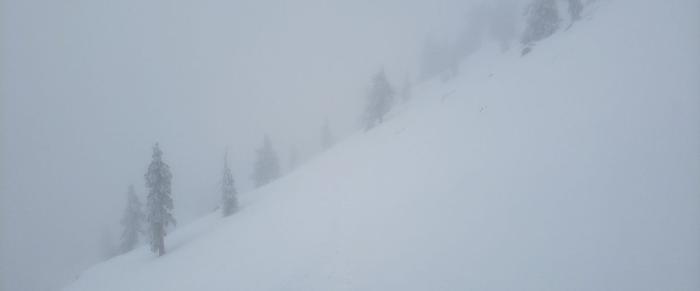
The third storm of this winter on Monday 28th December produced 15-17 inches of snow at all elevations above 5000ft, and a few inches down to near 4000ft in places. Strong Santa Ana winds on both 29th and 31st December undid some of the hard work of breaking trails in the high country, but the holiday weekend over the first three days of January resulted in further trails being established. A significant change in the forecast to unseasonably warm conditions at all elevations is already producing rapid melting at lower and mid elevations, and softening snow higher up. The latter was very striking by noon yesterday above 8500ft, and this will continue to worsen throughout this week.
Many major trails have now been traveled, and conditions are discussed below for specific trails where known. In addition to those, there are posthole tracks around the Tahquitz area meadows on Willow Creek and Caramba trails, to Chinquapin Flat and to Tahquitz Peak. There are no tracks emerging at Wellman Divide from Round Valley. Nevertheless, cautious navigation is strongly recommended everywhere. Snow depths measured today are listed at the foot of this posting.
Snowshoes are recommended everywhere above about 9000‘, and can be useful in less exposed areas down to 7800’ (e.g. around the Tahquitz area meadows). Elsewhere (and in addition), spikes are recommended for the foreseeable future in most areas above about 6000′, especially in the morning and for descending, as established trails become consolidated by hiker traffic and undergo freeze-thaw cycles.
Despite temperatures above seasonal averages, hikers should nevertheless be prepared for temperatures near or below freezing in the high country, and below freezing when considering wind chill effects (see below for recent temperatures at San Jacinto Peak).
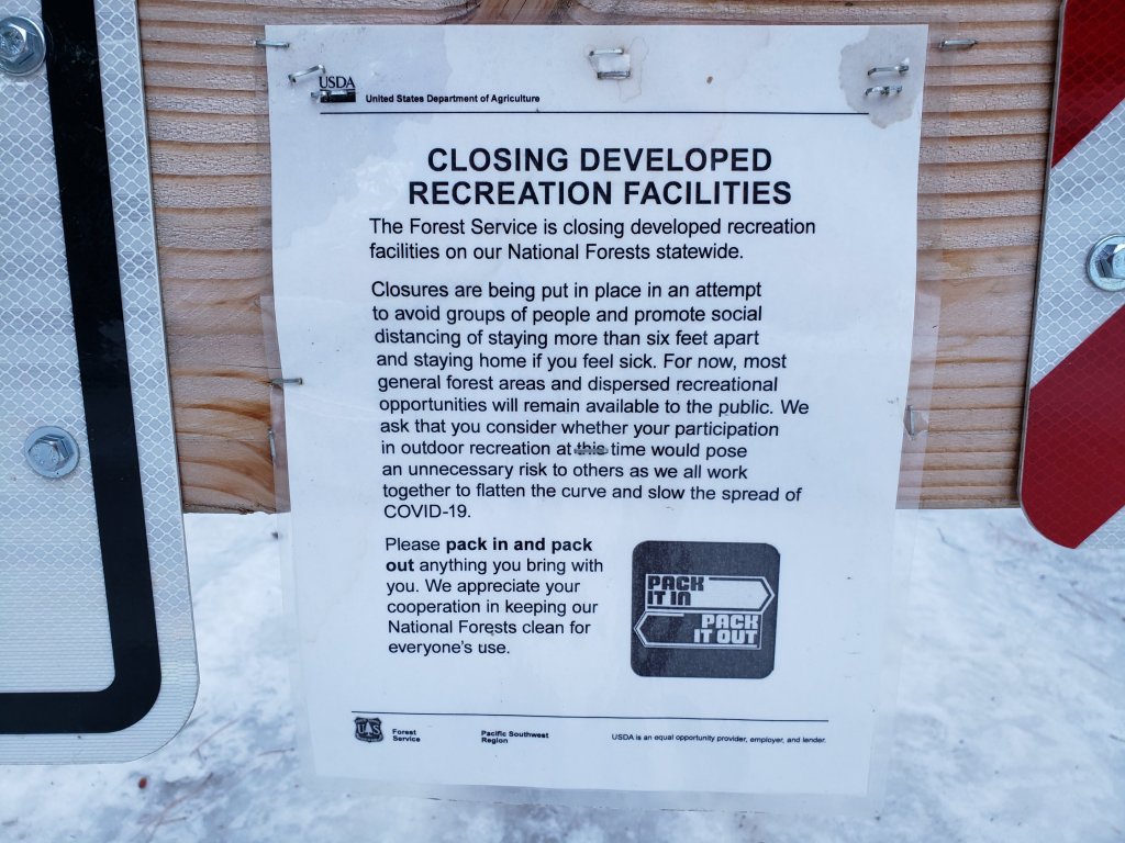
For details regarding coronavirus closures, hiking permits, camping restrictions, ranger station access, and the Tramway, please see this earlier report, or contact the State Park or Forest Service as indicated on their websites.
The USFS gate at Humber Park is closed. There is legal parking for nine vehicles. On weekends, the uppermost 0.1 mile of Fern Valley Road may also be closed at its junction with Forest Drive. Park along Forest Drive to access the Devil’s Slide and Ernie Maxwell trailheads.
On my ascent of San Jacinto Peak on New Year’s Eve, I was treated to a half-inch snow storm that had not been forecast, which bubbled up, and almost as quickly disappeared, for an hour or so around noon. It was a useful reminder of the unpredictability of weather in the high mountains. The strong winds and spindrift meant I had to break trail on the ascent, and rather unfairly break it again on the descent! I recorded a short thank you video to 2020 supporters of the Report just below the summit that day. That final ascent of 2020 was my 207th of the year, part of 1.24 million feet of elevation gain in 2020 (both records for the San Jacinto mountains).
WEATHER Temperatures are forecast to be well above seasonal for at least the first half of January, with daytime highs at least 5-10°F above average at the elevation of Idyllwild. The impacts will be especially pronounced at higher elevation, with the peaks above 10,000ft forecast to have air temperatures at or above freezing into mid month, far above typical for January. Snow melt will accelerate in the next few days, especially on sun-exposed slopes.
At San Jacinto Peak (10,810ft/3295m) on Monday 4th January 2021 at 0945 the air temperature was 34.3°F (1°C), with a windchill temperature of 20.4°F (-6°C), 46% relative humidity, and a moderate due West wind sustained at 13 mph gusting to 21.7 mph.
At the Peak on Thursday 31st December 2020 at 1150 the air temperature was 13.1°F (-11°C), with a windchill temperature of -6.9°F (-22°C), 93% relative humidity, and a steady NNW wind sustained at 10 mph gusting to 14.9 mph, with light snow falling.
TRAIL CONDITIONS
Trails above about 5500ft are largely snow-covered, with snow cover increasingly patchy below 7000ft depending on aspect. Warm temperatures are making for ugly snow conditions at all elevations, with soft, wet, and unpredictable snow increasingly prevalent at all elevations.
Tahquitz Peak trail from Chinquapin Flat/PCT Mile 178 has limited steps to follow through the steeply angled icy snow, which may be partially eliminated at any time by strong winds drifting snow. These icy slopes are treacherous. Currently spikes (ideally with an ice axe if you know how to use one) are strongly recommended. Snowshoes are not advised due to the angle of the icy snow.
Deer Springs Trail has a relatively well-traveled posthole trail to follow to Little Round Valley. Beyond there, there is a single challenging posthole track to San Jacinto Peak (which is relatively direct and does not follow the trail route as such).
Marion Mountain Trail has a relatively well traveled posthole track through the snow to its junction with the PCT/Deer Springs Trail. Spikes are especially valuable for descending.
Devil’s Slide Trail has a well-traveled icy snow track to follow. Spikes are recommended. Snow is melting in patches below 7500ft, and especially on sun-exposed slopes below 7000ft.
North of Saddle Junction on the PCT there is a well worn posthole track for about 1.3 miles (to the top of “Angel’s Glide” at about 9000ft) for which spikes are useful. Thereafter, hikers attempting to summit San Jacinto Peak via the Wellman and Peak trails are recommended to switch to snowshoes and follow the clear snowshoe track to the Peak. Snow depths on this route make for atrocious postholing conditions as the snow softens after mid morning.
The Ernie Maxwell Trail [updated 8th January] is now largely clear in its lower 1.8 miles. Icy snow patches cover about 20% of the upper part closest to Humber Park. Spikes remain helpful especially for descending in the morning.

SNOW DEPTHS measured on 4th January 2021 as follows (with comparison to six days earlier on 29th December 2020). Note that average depth is given; due to strong winds there can be extensive drifting, especially in the trails. Altitudes are approximate.
San Jacinto Peak (10810′): 15 inches (17 inches on 29th December 2020)
Wellman Divide (9700′): 9 inches (15 inches on 29th December 2020)
Annie’s Junction/approx. PCT Mile 181.8 (9070′): 13 inches (15 inches on 29th December 2020)
Saddle Junction/approx. PCT Mile 179.9 (8070′): 12 inches (16 inches on 29th December 2020)
Devil’s Slide Trail at Humber Park (6550′): 8 inches (14 inches on 29th December 2020)
Idyllwild (at 5550′): 5 inches (15.5 inches on 29th December 2020)
San Jacinto Trail Report: available for everyone, funded by readers. While all labor and time is volunteered, this Report completely depends on small private donations to cover its costs. In an especially challenging year, and with a busy winter already well underway, every contribution is invaluable. If you have found this Report useful, please consider visiting the Donate page. Thank you.
