Again I’ve spent the last three days camped in the San Jacinto high country, hiking extensively on the trail system and elsewhere.
Autumnal weather arrived abruptly (and in some style) on Monday evening, with strong, chilly winds dominating the high country for the past two nights. I documented the spectacular cloud effects at sunset on Monday 16th at San Jacinto Peak in a short video, available here on YouTube.
The status of water sources, most of which having experienced significant declines in flow rates in the past couple of weeks, is updated below. The status of highway closures is unchanged and is described at the foot of this posting.
Hikers should be prepared for autumnal temperatures at or below freezing above about 10,000′ elevation (but potentially lower), at least when considering windchill effects.

WEATHER Autumnal temperatures dominate, accompanied by extremely low humidity and periodic strong winds at the highest peaks. Windchill values at or below freezing overnight, generally above 10,000′ elevation, are now typical. There is a chance of precipitation on several days next week (25th-29th September).
At San Jacinto Peak (10,810’/3295m) today, Wednesday 18th September 2019 at 0620 the air temperature was 42.9°F (6°C), with a windchill temperature of 30.9°F (-1°C), 7% relative humidity, and a potent SW wind sustained at 27 mph gusting to 31.8 mph.
At the Peak on Tuesday 17th September 2019 at 0625, the air temperature was 38.0°F (3°C), with a windchill temperature of 24.2°F (-4°C), 35% relative humidity, and a fresh WSW wind at 17 mph gusting to 26.4 mph.
TRAIL CONDITIONS
All trails, including the entire Pacific Crest Trail throughout the San Jacinto mountains, have been free of snow since the end of June.
Hikers planning ascents of Skyline Trail are reminded that the Palm Springs Aerial Tramway is closed for maintenance 9th-29th September. Warning signs have been posted at the Ramon and Museum trailheads by friend of the Trail Report, Florian Boyd.
The Pacific Crest Trail remains open at the rockslide near Antsell Rock (Mile 172.5). The video report from late May (available here) can be useful for deciding whether to try to hike around the rockslide.
Forest Service closures to the Boulder Basin and Black Mountain Group campgrounds (both accessed from Black Mountain Road), and Dark Canyon Road, will remain in place all year. Consequently, Dark Canyon campground is also closed, and there is no vehicular access to Seven Pines trailhead.
Seven Pines Trail has at least 35 trees down, almost all above 7500′ elevation. State Park has apparently scheduled work this month to remove some or most of these obstructing trees. This trail has been very lightly traveled since 2018, and is indistinct in places. Hikers without considerable prior experience of this trail should take great care with routefinding.
The Caramba Trail from near Reeds Meadow through Laws Camp to Caramba, and the Cedar Trail from Willow Creek Trail to Laws, are not maintained. Temporary signage to this effect has been in place since the end of June. Both trails are indistinct in places, and hikers without considerable prior experience of this area should use cautious navigation.
The Cranston Fire closure order expired at the beginning of August. Although this does not impact the wilderness trail situation, it does mean that the popular dirt roads and mountain bike trails of the May Valley and Bonita Vista roads area are now open.
WATER STATUS: Eastern slope
The Round Valley spigot continues to flow well at about 2.0 gpm.
Both the northern and southern springs at Wellman’s Cienega are flowing steadily. These springs are the sources for Willow Creek, which is flowing well where it crosses the Willow Creek Trail.
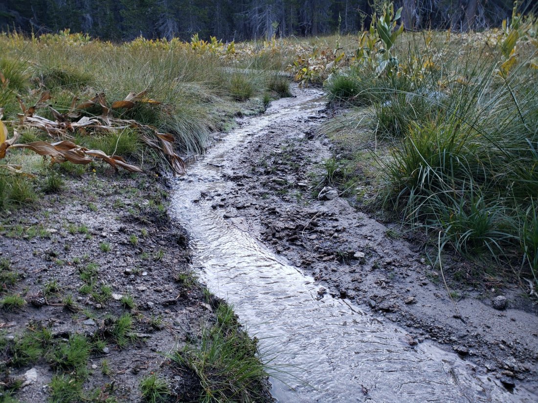
Tahquitz Valley continues to flow gently where it crosses the meadow trail, the first time in some seven years that this has flowed all summer.
Tahquitz Creek is flowing well at the northern end of Little Tahquitz Meadow. It is also flowing gently further upstream at its source (known locally as Grethe Spring) where it crosses the PCT (approx. PCT Mile 177).
Candy’s Creek – that flows through Skunk Cabbage Meadow and then crosses the Caramba Trail near Reeds Meadow – is flowing gently, but is very overgrown with thick vegetation, and is too shallow for easy filtering. It is much more accessible where it is flowing steadily across the Caramba Trail.
WATER STATUS: Western slope
The North Fork of the San Jacinto River is flowing well both where it crosses the Deer Springs Trail and the Fuller Ridge Trail on the PCT (approx. PCT Mile 186.0).

O’Sullivan Creek (PCT Mile 186.4) on Fuller Ridge Trail is also flowing.
The creek in Little Round Valley is flowing at its strongest in at least six years, but the flow rate continues to decline steadily.
Shooting Star Spring (below Little Round Valley but above the North Fork of the San Jacinto River crossing) is flowing well.
The Deer Springs stream crossing at the PCT (approx. PCT mile 185) is flowing well.

Switchback Spring (about 0.4 miles north of Strawberry Junction) is now flowing only gently, there is very little depth in which to filter water, and it is heavily overgrown.
Strawberry Cienega spring is flowing very gently. The tiny pool between the rocks, formerly good for filtering, filled with sediment over the winter.
On Devil’s Slide Trail, Middle Spring is flowing very weakly now.
On the Ernie Maxwell Trail, the crossing of Chinquapin Creek just below Humber Park continues to flow well just upstream of the trail. Intermittent diversion by Fern Valley Water District (who unhelpfully refer to it as Tahquitz Creek!) results in the flow across the actual trail being unreliable at present. This creek is an important source of water for the many dogs walked on this trail.
WATER STATUS: Desert Divide
Live Oak Spring (N 33 37 21, W 116 33 24) Flowing well. The most reliable water source on the Desert Divide.
Cedar Spring (N 33 40 36, W 116 34 35) Flowing well. Easiest access is the trough just upstream from the trail to the campsite.
Apache Spring (N 33 43 11, W 116 37 13) Flowing weakly. The trail off the PCT to this spring was greatly improved earlier this summer.
Spitler Peak Trail Descending this trail from the PCT there are five water crossings. The first two, at 0.9 and 0.95 miles down, cross a tiny side creek which is largely dry and should be ignored. The next three crossings, at 1.1 to 1.3 miles down, are Spitler Creek, which continues to flow gently.
Antsell Rock Creek (N 33 41 52, W 116 39 08) Right by the Spitler Peak Trail trailhead on Apple Canyon Road, Antsell Rock Creek is flowing well. Just on the upstream side of the road there is excellent access to the creek. Useful if hikers are descending the Spitler Peak Trail.
ACCESS CLOSURES The Valentine’s Day 2019 flood events continue to make access to the San Jacinto mountains challenging, however the news is encouraging. Highway 243 between Banning and Idyllwild is closed from Skyland Ranch (north of Bay Tree Spring) to just north of Lake Fulmor. This highway is now estimated to reopen on 1st November 2019, with some form of traffic control (details to be determined). Highway 74 from Mountain Center to Hemet reopened full time, but with a pilot car, on 30th August, likely continuing until October.

Thank you again for these reports, I could never get there…perhaps on a horse or mule? I look forward your posts!
LikeLike