[UPDATE 19th May 2019, 1150: Rainfall so far today has been 0.68″ in Idyllwild. It snowed barely an inch over 6000′ overnight, with 2″ (5cm) snow at San Jacinto Peak. Much snow has already melted this morning at the elevation of Long Valley (8500′). After some rainfall, it is now sleeting again in the high country. Extreme winds have been reported, especially along the Desert Divide (approx PCT Miles 157-175).]
[WEATHER UPDATE 18th May 2019: A winter weather warning has been issued for the next two days available here. Although these tend to overestimate snowfall in the San Jacinto mountains, some precipitation is likely and it will be very cold. Temperatures well below freezing (10-30 degrees below freezing with windchill) are expected for much of the next six days, 19th-24th May, in the San Jacinto high country.]
Yesterday we hiked to San Jacinto Peak in the rain, hoping for some snow up high. After a few hours around the Peak we descended via Wellman Divide and Devil’s Slide Trail in clearer conditions. The rain started and ended a couple of hours earlier than forecast, between about 0700-1300, and the system was milder than expected with no snowfall even at the Peak. In Idyllwild at 5550′ we received 0.20″ rain, but rainfall was significantly heavier than that between about 8000-10,000′ elevation.
I recorded the following short video at San Jacinto Peak on 16th May.
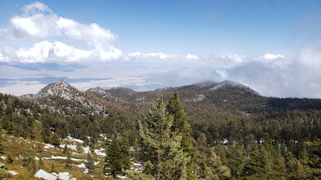
At about 1400 as we descended, the high country cleared (see photo below) but Idyllwild and the mountain below about 9000′ largely remained in the cloud until dusk.
Details of trail conditions are below. I am no longer updating snow depths as most areas below 10,000′ are largely clear (albeit with some persistent drifts around). Currently I am not updating water conditions. Due to rainfall and rapid snow melt all established water sources are flowing well, and many ephemeral sources are flowing also.
With this mild system and rainfall, melting has continued rapidly. The PCT in the San Jacinto mountains is now safely passable for hikers without microspikes. Depending on confidence and experience on icy snow, some PCT hikers may still prefer to use microspikes, especially on the north end of Fuller Ridge (aroud Mile 190).
Microspikes remain useful (but not essential) above 9700′ in some areas, especially descending from San Jacinto Peak, in particular on the western (Deer Springs Trail) route.
WEATHER Following a couple of milder days, there is the chance of light precipitation on most days from Sunday 19th to Thursday 23rd May. Temperatures will be below seasonal averages, and at or below freezing in the high country (well below freezing with windchill). Light snowfall at the highest elevations is a possibility on several days in the next week.
At San Jacinto Peak (10,810ft/3295m) yesterday, 16th May 2019, at 1345 the air temperature was 27°F (-3°C), with a windchill temperature of 8.4°F (-13°C), 100% relative humidity, and a sharp SW wind at 15 mph gusting to 24 mph.
At San Jacinto Peak on 11th May 2019, at 1530 the air temperature was 30°F (-1°C), with a windchill temperature of 15°F (-9°C), 97% relative humidity, and a fresh NE wind at 12 mph gusting to 20 mph.
TRAIL CONDITIONS
Trails above about 8700′ remain partly snow-covered. All main trails are now well traveled, and have good tracks to follow which largely align with the established trail system.
Pacific Crest Trail The trail is clear of snow from Highway 74 (Mile 151) to about Mile 174 (Red Tahquitz) after which the trail has a few snow patches to about Mile 179. There is a short section with about 80% snow cover near Mile 181. There is patchy snow on Miles 185-186 at about 30% coverage.
Fuller Ridge Trail (approx. PCT Miles 185.5-190.5) can be traversed without microspikes, although they are useful for those less experienced on angled icy snow. Snow patches are frequent enough to use microspikes for parts of the five mile length of the Fuller Ridge Trail, briefly around Miles 187.5-188, and then more continuously on Miles 188.5-190. Particularly at the northernmost end, the track does not follow the trail in places, and there are a couple of steeper descents.
San Jacinto Peak trails On the eastern side, the Wellman Trail from Annie’s Junction (PCT turning near Mile 181.5) to Wellman Divide (9700′) is clear of snow. The Peak Trail from Wellman Divide to the Peak averages less than 20% snow-covered and the track now largely follows the trail route, but microspikes remain useful, especially for descending those areas where stubborn icy snow patches remain. The East Ridge Trail remains almost completely under snow. On the western side, the upper Deer Springs Trail from Little Round Valley is about 60% snow-covered through the Valley, 50% covered on the ascent to the Peak, and about 50% snow-covered at San Jacinto Peak itself. The tracks through the snow patches now largely follow the route of the Deer Springs Trail. Microspikes are recommended in places, especially for descending from the Peak to about 9600′.
Tahquitz Peak trail from Chinquapin Flat was updated in detail earlier this week. Microspikes are no longer required for the steps through the very short remaining sections of icy snow.
Black Mountain Road is clear of snow. No microspikes are required to hike to the PCT. The road has been cleared, repaired, and partially graded to the turning to Boulder Basin, and cleared and repaired to the Fuller Ridge campground.
Skyline Trail is clear. C2C hikers have not been encountering snow until well past Long Valley Ranger Station.
Devil’s Slide Trail is clear of snow.
Tahquitz meadows trails are clear of snow with only occasional small patches to cross. No microspikes required.
Deer Springs Trail is clear of snow to Strawberry Junction (8100′) and almost completely clear to the Seven Pines Trail junction. There is about 20% snow cover from there to the Fuller Ridge Trail junction, but microspikes are no longer required. The track above the Fuller Ridge junction now follows the trail and there is only about 20% snow cover as the trail nears Little Round Valley. For the section through and beyond Little Round Valley, see “San Jacinto Peak trails” above.
Marion Mountain Trail is clear of snow.

Hi Jon. The trees to the right (south) of Cornell in your image seem rather brown. Are they distressed or an artifact of the image? I don’t remember them looking so brown.
LikeLike
I think it is likely a lighting artifact but stress is a possibility. I haven’t personally been up close to trees in that area for months, so it would be worth a look this summer. Thanks.
LikeLike