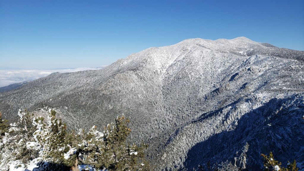
This is a summary of conditions following the only notable (so far) snow storm of winter 2024/25, albeit a minor storm by the standards of the San Jacinto mountains, with snow falling on 26th and 27th January. As is increasingly the trend with a rapidly changing climate in recent years, the snowfall did not fit an obvious altitudinal pattern (in which snow depth generally increases at higher elevations), with storm totals of about four inches at both Idyllwild (at 5550ft) and at San Jacinto Peak (10,810ft). The greatest depths I measured were between 7500 and 9500 ft, peaking at 6.5 inches at Saddle Junction (8100 ft).
The storm system was not a conventional “atmospheric river” originating well to the west, but came from a stalled “cut off” low pressure system around which the jet stream took a sinuous path from northern Canada. Consequently the system was cold, with a dusting of snow below 4000 ft on the morning of 27th, and the slow movement resulted in light snow continuing on/off for most of two days. The bulk of the snowfall was nevertheless concentrated in two phases, in the early hours of Sunday 26th, and then again overnight into the early hours of Monday 27th.
I broke trail to San Jacinto Peak via Devil’s Slide, Wellman, Peak, and East Ridge trails on Sunday 26th January, enjoying the conditions so much that I then repeated the same route, again breaking trail through further fresh snow, on Monday 27th. I recorded short video reports from the Peak on both days (linked here for Sunday 26th, and here for Monday 27th). We broke trail up South Ridge to Tahquitz Peak on 29th, and also put in a trail on the north side of Tahquitz between the peak and Chinquapin Flat.
Currently some trails have not been traveled and most are somewhat obscured by light snowfall. On my descent on the afternoon of 27th I noted that apart from Devil’s Slide Trail (and my own tracks on the PCT northbound ultimately heading to San Jacinto Peak) there were no other broken trails away from Saddle Junction. This will change soon with limited hiker traffic, but cautious navigation is recommended everywhere. Snow depths are listed at the foot of this posting, but note that due to drifting, snow is sometimes deeper in the trails themselves.
Snow depth and structure are both currently suitable for spikes above roughly 7000 ft, and spikes will become increasingly valuable as established trails become consolidated by hiker traffic and undergo freeze-thaw cycles. With rapid melting expected in the next week, the elevation at which spikes are needed will rise quickly. Snow depths are generally insufficient for snowshoes (except possibly around the Tahquitz area meadows for the next day or two) and crampons/ice axe are not required anywhere.
Hikers should be prepared for temperatures below freezing in the high country, and well below freezing when considering wind chill effects until Thursday 30th (see below for my recent weather observations from San Jacinto Peak).
The USFS gate at Humber Park closed on Sunday 26th January. Even when closed there are nine legal parking spaces immediately below the gate. Vehicles not parked in these spaces have been ticketed in past winters. South Ridge Road remains (unexpectedly) open and is readily passable with AWD/4WD vehicles.
WEATHER
Temperatures are forecast to remain below seasonal averages until Thursday 30th, with no significant further precipitation in January, although a possibility of light precipitation on the afternoon of Tuesday 28th. Temperatures are then forecast to rise dramatically to far above seasonal starting Friday 31st, with both daytime highs and overnight lows 10-15°F above average for January/February. The high country will not be spared, with temperatures also some 15°F above normal during the first couple of days of February. This will obviously very rapidly accelerate snowmelt at all elevations.
Temperatures are expected to cool somewhat into the second week of February, with light precipitation currently forecast for Wednesday 5th. This rainfall may be confined to the mid elevations with about 0.25 inch forecast for Idyllwild, with the high country forecast to be above the cloud with no snow expected at this time.
The latest video report from National Weather Service San Diego (linked here) summarizes the recent storm event and describes the weather patterns for the next week.
At San Jacinto Peak (10,810ft/3295m) on Monday 27th January 2025 at 1040 the air temperature was 16.0°F (-9°C), with a windchill temperature of 9.0°F (-13°C), 74% relative humidity, and a remarkably calm hint of a NNW breeze sustained at 0 mph gusting to 2.8 mph.
At the Peak on Sunday 26th January 2025 at 1110 the air temperature was 17.8°F (-8°C), with a windchill temperature of -3.8°F (-20°C), 100% relative humidity, and a cool WSW wind sustained at 9 mph gusting to 15.9 mph.

TRAIL CONDITIONS
For details of specific trail conditions (and water availability) prior to this latest minor storm, see the previous Report (linked here).
All trails above about 6000 ft are at least partially snow-covered. By the afternoon of 27th melting was already underway below 6500 ft, and this will accelerate rapidly over the next few days. Reliable tracks are currently only known to be in place for Devil’s Slide Trail through to San Jacinto Peak via Wellman Divide.
Devil’s Slide Trail has a relatively well-traveled track to follow.
Deer Springs Trail has a reliable track through the snow all the way to San Jacinto Peak as of Thursday 30th.
South Ridge Trail has a lightly traveled posthole track through to Tahquitz Peak as of Wednesday 29th. On the same day we put through a track on the north side to and from the Peak to Chinquapin Flat, where snow depth averages five inches but is drifted to 8-12 inches in the trail.
The Ernie Maxwell Trail has a well-traveled track to follow.

SNOW DEPTHS
Numbers given here are storm totals, measured initially on 26th then again on 27th January 2025, after each of the two main periods of snowfall. Note that average depth is given; some drifting and accumulation has occurred, especially in trails. Altitudes and PCT Miles are approximate.
San Jacinto Peak (10810 ft): 3.5 inches
Wellman Divide (9700 ft): 5.0 inches
Annie’s Junction/approx. PCT Mile 180.8 (9020 ft): 5.0 inches
Tahquitz Peak (8836 ft): 5.0 inches, drifted 8-12 inches on north side trail, and 6-8 inches on uppermost South Ridge Trail
Long Valley (8400 ft): 4.5 inches
Saddle Junction/approx. PCT Mile 179 (8070 ft): 6.5 inches
Devil’s Slide Trail at Humber Park (6550 ft): 5.0 inches (largely melted by 29th)
Idyllwild (at 5550 ft): 4.0 inches, largely melted by afternoon of 27th.

While all time and labor is volunteered, the San Jacinto Trail Report uses small private donations to help cover operating costs. Your contribution keeps the Report available to all, free from advertising or paywalls, and independent from agencies. If you have found this Report useful, please consider using this link to the Donate page. Thank you very much for your support.


One thought on “Minor snow storm update 29th January 2025”