Hikes every day, including four ascents of San Jacinto Peak in the past five days by different routes, have allowed for a thorough check of water sources and trail conditions. A brief period of relatively cool weather (although still above seasonal averages!) in recent days included, on Monday 31st August, the first windchill temperature below 40°F recorded at San Jacinto Peak in exactly two months. Regrettably, these few cool days will be short-lived, with another spell of record heat forecast starting Friday 4th September until Tuesday 8th.
Hikers should be prepared for unseasonably hot weather, with temperatures far above seasonal, the overnight low temperatures in particular 15-22°F above average this weekend. Please give considerable extra thought to route choice, start times, clothing, sun protection, and water requirements. Air quality in the mountains had improved markedly in recent days, but then deteriorated again dramatically today (3rd September) with a switch in wind direction.
Although monsoon conditions are not forecast for the foreseeable future, hikers should always be prepared for rapidly changing weather conditions in the high country in late summer. Thunderstorms with lightning, intense precipitation, and rapid temperature drops, most likely in the afternoon or evening, can occur at or near the high peaks even when such storms are not forecast for lower elevations.
Permits are required for hiking and camping in Mount San Jacinto State Park, see their website for details. The U.S. Forest Service ranger station in Idyllwild remains closed due to the coronavirus crisis. USFS day use permits are required again for the San Jacinto wilderness starting 1st September, and should be available at the kiosk outside the ranger station. USFS has indicated that a permit quota will not be enforced for Devil’s Slide Trail for Labor Day weekend. USFS campgrounds are open, except those mentioned elsewhere in this update.
Palm Springs Aerial Tramway is closed indefinitely (since 12th March) due to the coronavirus crisis. The Tram has brought forward the normal September maintenance program into August this year, although no tentative reopening date has been approved.
Black Mountain Road reopened on 20th June, having been graded through to the Fuller Ridge campground. Boulder Basin campground will remain closed all year.
WEATHER As mentioned above, relatively cool weather ends on Thursday 3rd September, after which record-breaking hot temperatures are forecast until about 9th September. A couple of cool days will be followed by yet another warming starting 11th. There is no significant precipitation in the forecast. Regrettably, for the fourth year in a row, the late summer monsoons have largely missed us, with only 0.08″ rain measured in Idyllwild in August. Fire risk remains severe.
The National Weather Service has issued an excellent video discussion of the record-breaking heatwave expected over the Labor Day weekend. The video includes a brief summary of an exceptionally hot and dry August, the hottest ever recorded for much of Southern California.
The past month was likely the hottest August in recorded Idyllwild history (pending final National Weather Service data). Remarkably, 24 of the 31 days in August recorded an overnight low temperature of at least 60°F. Historically the average low for Idyllwild in August is 54°F.
At San Jacinto Peak (3295m/10,810ft) on Thursday 3rd September 2020, at 0745 the air temperature was 53.7°F (12°C), with a windchill of 47.1°F (8°C), 37% relative humidity, and a steady due East wind sustained at 13 mph gusting to 20.8 mph.
At the Peak on Monday 31st August 2020, at 0745 the air temperature was 47.4°F (9°C), with a windchill of 39.7°F (5°C), 58% relative humidity, and a firm SW wind sustained at 10 mph gusting to 17.6 mph.
The warmest temperature I have ever recorded (to date) at San Jacinto Peak was on Wednesday 19th August 2020, when at 0745 the air temperature was 62.3°F (17°C), with no measurable windchill, 42% relative humidity, and calm, extremely hazy conditions.
TRAIL CONDITIONS
All trails have been clear of snow since early June. Many trails have treefall hazards from this past winter, passable for hikers but not for stock. Some are described in detail below, others include: PCT south of Red Tahquitz (approx. PCT Miles 173-175), PCT between Strawberry Cienega and Deer Springs camp (Miles 182-185), Fuller Ridge Trail near its northern end (PCT Miles 189.1-190.2), Spitler Peak, Cedar Spring, and Apache Spring trails. All significant tree hazards on Willow Creek Trail have now been removed.
Seven Pines Trail has been very lightly traveled since November 2018. There are 25 treefall hazards on the trail, almost all in the upper State Park section of trail, based on multiple June 2020 surveys. Very cautious navigation is recommended for those unfamiliar with this trail. The Forest Service closure of Dark Canyon Road is expected to continue into 2021, so there is currently no vehicular access to Seven Pines trailhead.
The Pacific Crest Trail remains open at the rockslide just north of Antsell Rock (Mile 172.5). USFS plans for removal of the rockslide have been delayed due to the coronavirus crisis. The video report (available here) can be useful for deciding whether to hike around the rockslide or take an alternate route.
Forest Service temporary signage indicates that the Caramba Trail from near Reeds Meadow through Laws Camp and on to Caramba, and the Cedar Trail from Willow Creek Trail to Laws, are “not maintained”. In reality both trails no longer exist. Both are so heavily overgrown I advise hikers do not attempt to follow them. Many experienced hikers have reported getting lost in this area since summer 2019. An informal use trail to Laws is much more direct and avoids all of the challenging bush-whacking of the unmaintained trails (some local hikers have dubbed it the “King Trail”). It leaves the Willow Creek Trail exactly 1.0 mile from Saddle Junction (0.46 mile from the Skunk Cabbage turning), descending largely on established deer trails for 1.2 miles, roughly paralleling Willow Creek just to its south. Be advised that it is an indistinct use trail, becoming less obvious as it nears Laws (by which time Willow Creek is close by on your left hand side, so navigation is not a challenge). From Laws east to Caramba the route of the original Caramba Trail is relatively easy to follow (for those who were familiar with this trail prior to the 2013 Mountain Fire). Nevertheless, cautious navigation is still advised.
WATER STATUS: Eastern slope
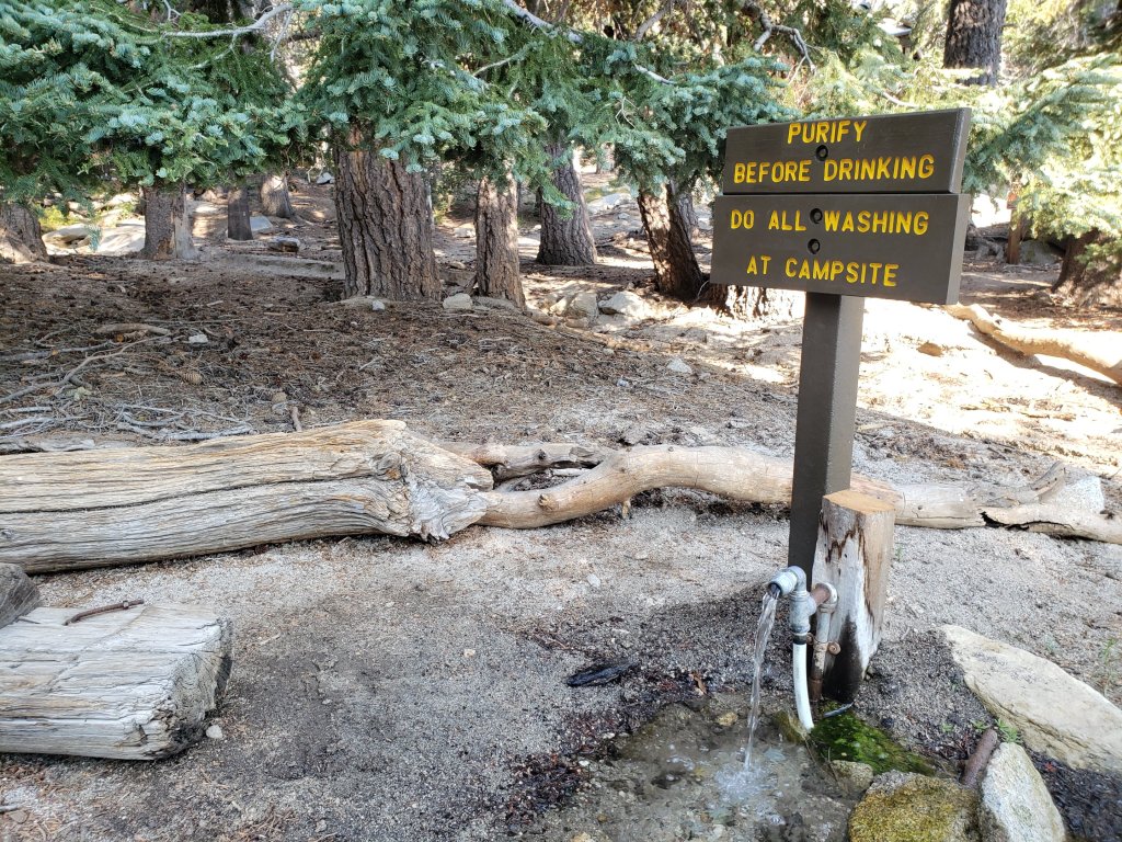
The Round Valley pipe is flowing again. Flow has periodically been redirected to the CCC/ACE camp in Long Valley and water pressure can be insufficient to also flow at the pipe (currently there is no maintenance crew camped in Long Valley). The nearby Round Valley creek dried up in early August.
The small creek in Tamarack Valley also dried up in August.
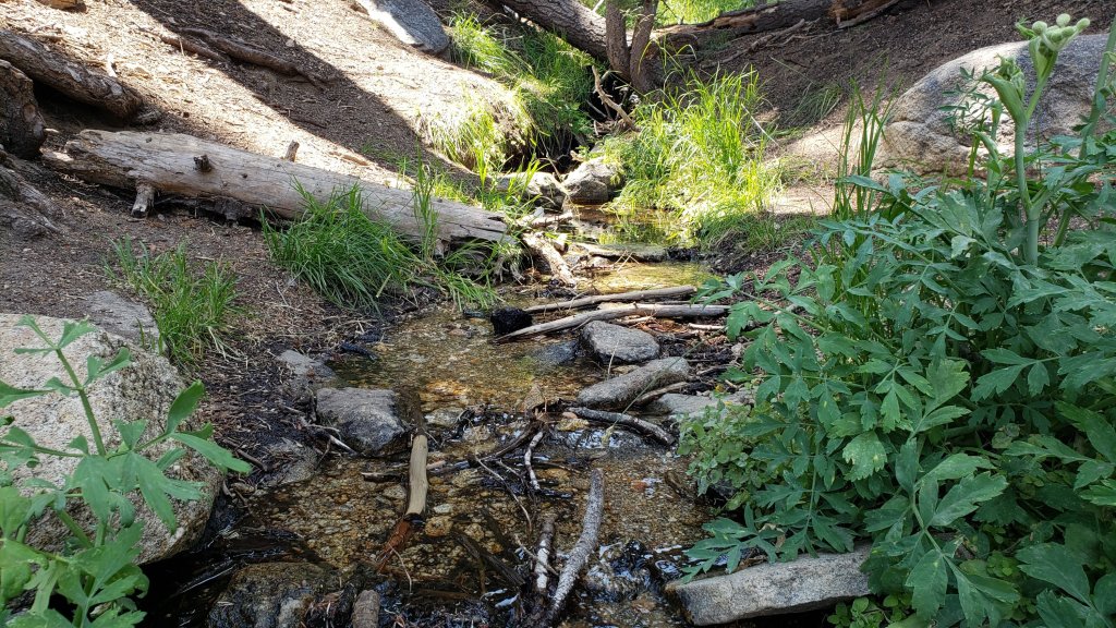
Both the northern and southern springs at Wellman’s Cienega are flowing gently. These are the sources for Willow Creek, which is flowing well where it crosses the Willow Creek Trail.
Tahquitz Creek is flowing well at the northern end of Little Tahquitz Meadow. It is also flowing further upstream at its source (known locally as Grethe Spring) where it crosses the PCT (approx. PCT Mile 177). The small creek in Tahquitz Valley dried up in early August.
Candy’s Creek – that flows through Skunk Cabbage Meadow and then crosses the remaining visible section of Caramba Trail near Reeds Meadow – is currently flowing gently in both locations.
WATER STATUS: Western slope
Ephemeral creeks, such as those along Marion Mountain Trail and on Deer Springs Trail, are now all dry.
The North Fork of the San Jacinto River is flowing well where it crosses the Deer Springs Trail and again downstream where it crosses the Fuller Ridge Trail on the PCT (approx. PCT Mile 186.2).
The creek in Little Round Valley is flowing, although at less than half the volume compared to this time last year. The same creek has now dried up where it crosses Fuller Ridge Trail (at about PCT Mile 186.4).
Shooting Star Spring (below Little Round Valley but above the North Fork of the San Jacinto River crossing) is flowing steadily.
The Deer Springs stream crossing at the PCT (approx. PCT mile 185.6) is flowing steadily, but flow rate dropped markedly in August.
Switchback Spring at PCT Mile 183.5 (about 0.4 miles on the PCT northbound from Strawberry Junction) is trickling, but there is not adequate depth in which to filter water.
The little creek at Strawberry Cienega (PCT mile 183.0) is now dry.
On Devil’s Slide Trail, Middle Spring continues to trickle gently. Other springs on this trail are dry.
On the Ernie Maxwell Trail, the crossing of Chinquapin Creek just below Humber Park is dry again where it crosses the trail. Even when Fern Valley Water District diverts flow into the pipe system, as it has for much of August, there are small fresh pools just upslope from the trail (this creek is an important source of water for the many dogs walked on the Ernie Maxwell).
WATER STATUS: Desert Divide
Live Oak Spring (N 33 37 21, W 116 33 24) Flowing well. The most reliable water source on the Desert Divide.
Cedar Spring (N 33 40 36, W 116 34 35) Flowing well. Easiest access is the trough 60 yards upstream from the trail to the campsite.
Apache Spring (N 33 43 11, W 116 37 13) Flowing very weakly.
Spitler Peak Trail Descending the trail there are five water crossings. The first two, at 0.9 and 0.95 miles down, cross a tiny side creek which is largely dry and should be ignored. The next crossing, at 1.1 miles down, is Spitler Creek and is the best source of water (currently flowing). The next two crossings are the same creek, but for obvious reasons it is best to fill up at the highest of the three crossings.
Antsell Rock Creek (N 33 41 52, W 116 39 08) Right by the Spitler Peak Trail trailhead on Apple Canyon Road, Antsell Rock Creek is flowing very well. Just on the upstream side of the road there is excellent access to the creek. Useful if hikers are descending the Spitler Peak Trail.
San Jacinto Trail Report: available for everyone, funded by readers. While all labor and time is volunteered, this Report completely depends on small private donations to cover costs. With an especially challenging year in 2020, every contribution is invaluable. If you have found this Report useful, please consider visiting the Donate page. Thank you.

I hiked down from South Ridge trailhead to Earnie Maxwell trailhead. I would not recommend attempting the road without 4-wheel drive. While most parts are OK, the first bit and a very rough and steep section with very fine sand just before the pavement starts definitely require it.
LikeLiked by 1 person
Hey Jon — Thanks for your excellent report as always. Wondering if you’ve been to the South Ridge trailhead lately — specifically wondering if the road has been plowed? Super hard to get in without four-wheel drive earlier in the summer.
LikeLiked by 1 person
South Ridge Road has not been graded, and I have heard from USFS that it is not a priority for this year.
LikeLiked by 1 person