Very hot temperatures far above seasonal even for July – close to 100°F (38°C) as high as 6000 ft – are forecast for 3rd-13th, with the hottest days expected to dangerously coincide with the extended holiday weekend. Overnight low temperatures in particular will be at least 15°F above seasonal into mid July. Hikers must be prepared for unseasonably hot weather in the high country, with temperatures well above seasonal at all times of day and at all mountain elevations. Please give considerable extra thought to start times, route choice, clothing, sun protection, and hydration requirements, or indeed whether it is wise to be hiking at all in such conditions.
A comprehensive fire ban is now in place on Forest Service lands throughout the San Jacinto Ranger District (link to USFS order here). Fires are completely prohibited in all camping areas, including those provided with fire rings. Fires are of course always prohibited throughout both the State Park and National Forest wilderness areas.
Survey hikes by the Trail Report every day year-round in the San Jacinto mountains include varied and often circuitous routes to San Jacinto Peak multiple times per week (most recently daily on 1st-5th July), plus many other trails on intervening days.
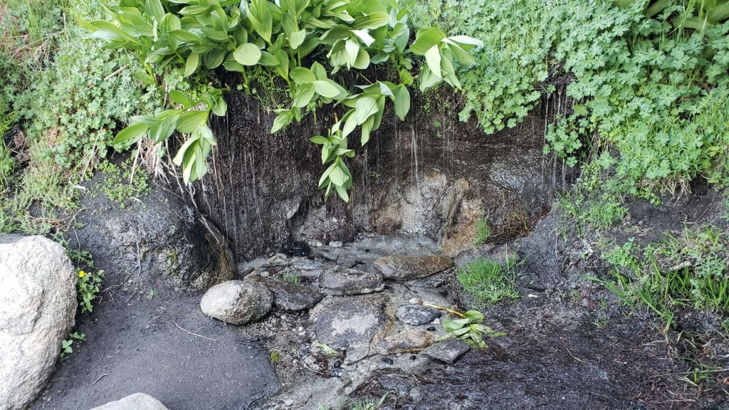
All major springs, creeks, and pipes are flowing relatively well at this time (example photos below). However flow rates are dropping steadily at upper elevations and most ephemeral water sources are now dry.
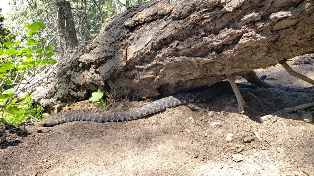
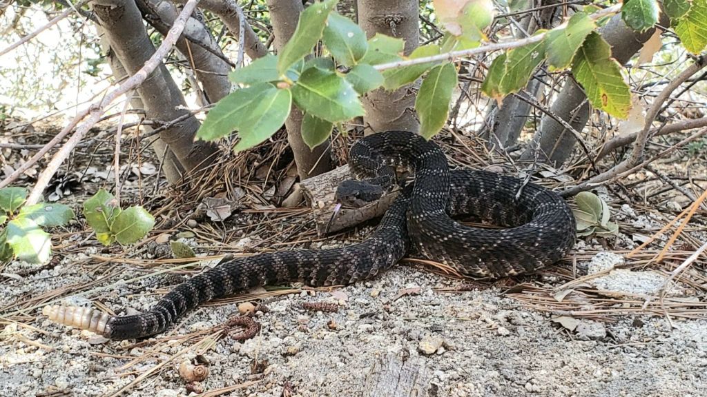
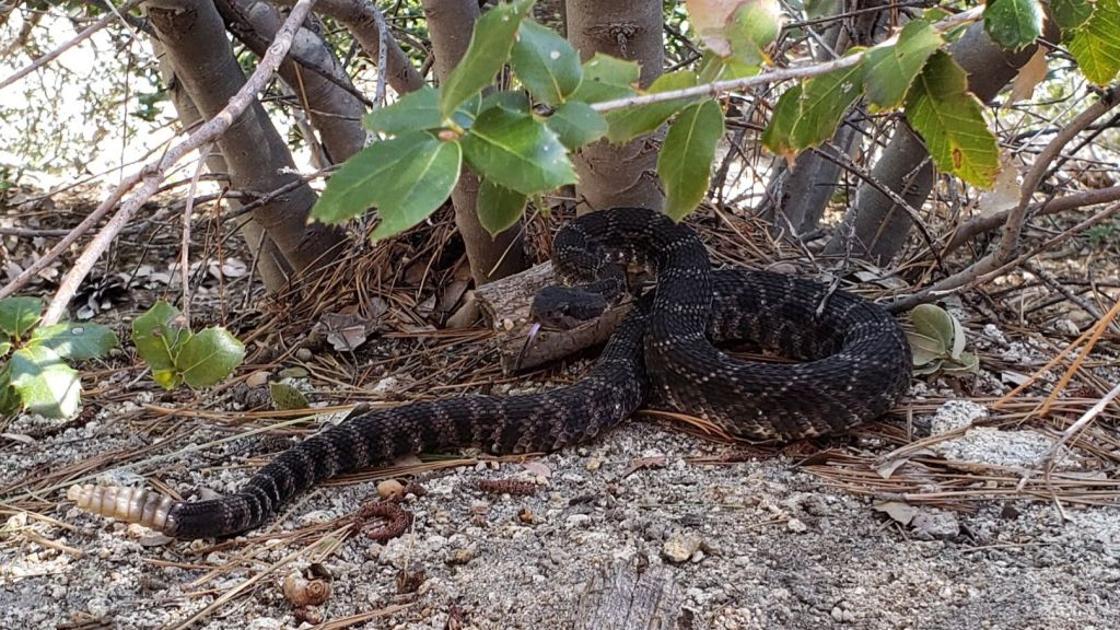
Be rattlesnake aware. Southern Pacific Rattlesnakes (Crotalus helleri) have been seen on the trail system up to at least 8800 ft elevation, and may be seen as high as 9300 ft. The volume of early season sightings suggested abundant snake populations this year in the San Jacinto mountains.
Be bear aware. Although rarely reported, up to three Black Bears have been in the San Jacinto mountains since 2017, where I have seen at least one annually for the past six years, most recently on upper Marion Mountain Trail on 14th September 2023. I found fresh prints in snow on 12th February this year at 9000 ft near PCT Mile 180.5 (photo here). Brief videos from Devil’s Slide Trail in September 2021 (available here) and at home in Idyllwild in 2018 (linked here) show two different individuals. There have been no reports of negative interactions with humans at or near campsites.
WEATHER
Above seasonal temperatures started on 21st June and this trend will continue into mid July (at least). Forecast temperatures suggest the first two weeks of July will be very hot and well above average for the month on 2nd-13th at least. There will be little relief in the high country, with near-record temperatures expected even above 10,000 ft elevation on 4th-12th July. As is increasingly the case with a steadily heating climate in the San Jacinto mountains, overnight low temperatures in particular will be well above seasonal into mid July. There is currently no significant precipitation in the forecasts, but a slim chance of light monsoonal rain on 13th-14th most likely around the highest peaks.
The latest video forecast issued on 2nd July by NWS San Diego (linked here) describes in detail the imminent “heat dome” that will impact us in early July, plus expectations for the remainder of the month.
At San Jacinto Peak (3295m/10,810ft) on Friday 5th July 2024 at 0645 the air temperature was 61.6°F (16°C), with a “windchill” temperature of 58.1°F (14°C), 24% relative humidity, and a steady NE wind sustained at 11 mph gusting to 13.5 mph.
At the Peak on Thursday 4th July 2024 at 0750 the air temperature was 64.4°F (18°C), with a “windchill” temperature of 59.8°F (15°C), 33% relative humidity, and a subtle ESE breeze sustained at 2 mph gusting to 4.1 mph.
At the Peak on Wednesday 3rd July 2024 at 0910 the air temperature was 61.4°F (16°C), with a “windchill” temperature of 58.5°F (15°C), 44% relative humidity, and a very light SSE wind sustained at 3 mph gusting to 6.2 mph.
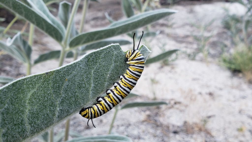
Monarch (Danaus plexippus) caterpillar on Woollypod Milkweed (Asclepias eriocarpa) at about 5600 ft in Idyllwild, 29th June 2024. The western population of Monarch butterflies has declined so rapidly (>90% in the past 40 years) that the species is under consideration for listing as federally endangered. We have been monitoring Monarchs and reporting observations from the San Jacinto mountains for several years.
TRAIL CONDITIONS
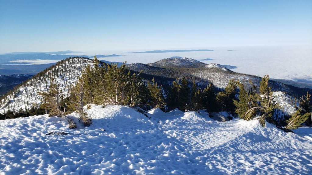
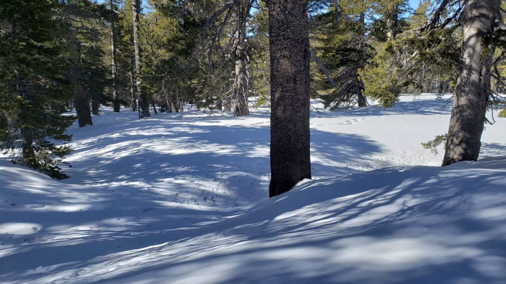
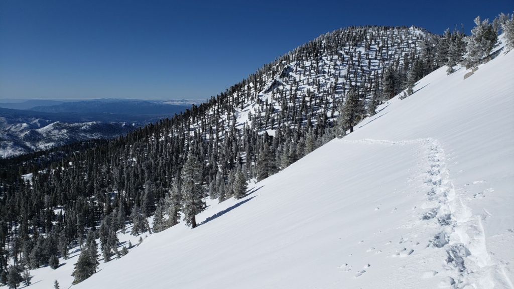
Snow was gone from the high country trails by mid June.
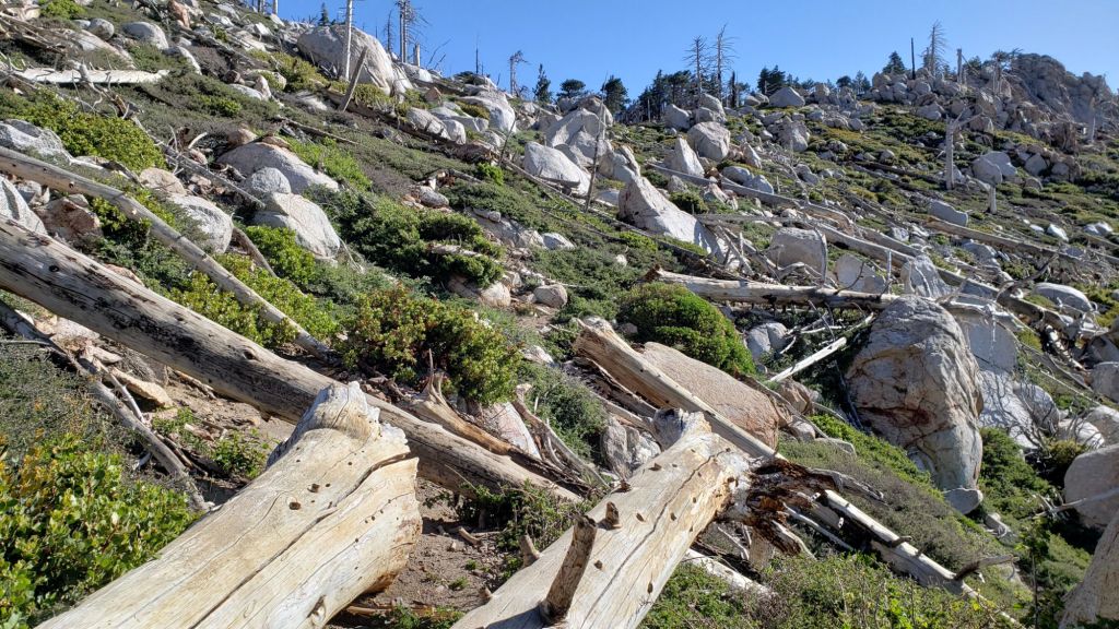
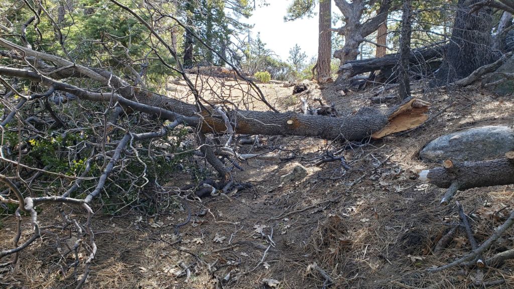
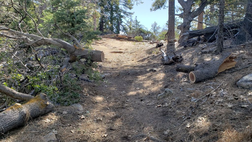
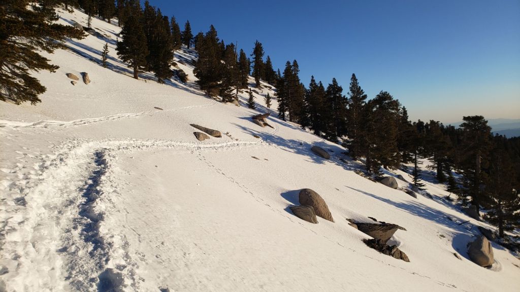
About 12 treefall hazards on Deer Springs Trail include 8-9 in the upper trail that have been down and reported repeatedly for years but with no action from the State Park. All but one of the treefall hazards down between Strawberry Junction and the top of Marion Mountain Trail (roughly PCT Miles 183-185) were removed by the Trail Report in late June (example photos below).
Willow Creek Trail is in much more hiker-friendly condition than this time last year. Smaller treefall hazards on the Forest Service section were cut in June. The two huge (c.50 inch diameter) hazards remaining on the Forest Service side are being removed in early July. Whitethorn along the trail has not (yet) grown back significantly, other than a couple of minor areas near Hidden Divide in the State Park section. Treefall hazards currently on the State Park side include two large ones remaining from last year, plus three small new ones, but none pose significant problems for hikers.
Treefall hazards remain a major problem along parts of the Pacific Crest Trail, most notably between Antsell Rock and Red Tahquitz, with 132 recorded in my June 2024 survey between Miles 170.5-175.5. The disinterest of Forest Service and PCTA in maintaining this section of trail for the past five years is unconscionable. A further 15 smaller trees are down from Miles 168.5-170.5 (Spitler Peak Trail to Zen Center Trail). Concentrations of large downed trees make for especially slow-going around Miles 170.5-172 (east side of Antsell Rock) and Miles 174-175 (south and east sides of Red Tahquitz).
The Trail Report cleared this winter’s accumulated treefall hazards from South Ridge Trail in April and has also undertaken extensive trail trimming in the first half of this year.
The 34 treefall hazards that came down across Spitler Peak Trail during ice storms in February 2024 were almost all cleared by the Trail Report on 14th June. The couple of minor stepover branches that remain pose no problem for hikers. This work brings to 120+ the total number of trees removed by the Report from this trail in the past three years. Currently the upper trail in particular is heavily overgrown with lush seasonal vegetation.
The Caramba Trail from near Reeds Meadow through Laws Camp and on to Caramba, and the Cedar Trail from Willow Creek Trail to Laws, are euphemistically described by the Forest Service as “not maintained”. In reality both trails have been abandoned and functionally no longer exist. They are so heavily overgrown with dense whitethorn, which obscures dozens of downed trees, that I strongly advise hikers do not attempt to follow them (regardless of how much you may trust an app). An informaluse trail to Laws is much more direct, maintained, and avoids the challenging bushwhacking of the unmaintained trails (local Idyllwild hikers dubbed it the “King Trail” when I established the route in 2019). It leaves Willow Creek Trail exactly 1.0 mile from Saddle Junction, 0.46 mile from the Skunk Cabbage turning (trailhead at N 33.7796, W 116.6590). The route descends largely following established deer trails for 1.2 miles, meeting Willow Creek about 0.2 mile upstream from the site of the historic Laws Camp (the remains of which were destroyed by the 2013 Mountain Fire and subsequent flood and treefall damage). Eleven trees down on the King Trail were removed in June-July 2023. The tread of the trail received some damage from Tropical Storm Hilary last year. From Laws east to Caramba the route of the original Caramba Trail has been well-cairned by myself and others and can largely be followed with very careful route-finding. My 2023 survey counted about 110 trees down on this 2.1 miles of trail. It is especially obscure for the first 0.3 mile east of the Willow Creek crossing, becoming more obvious (but still subtle) as it descends towards Caramba. Very cautious navigation is advised throughout the area.
The Trail Report has “adopted” Seven Pines Trail as a priority for maintenance work as the trail has had a disproportionate number of lost hiker rescues in the past decade, and it has been functionally abandoned by both the State Park and Forest Service for years. Since 2020 about 75 downed trees have been cut and the trail is thoroughly trimmed and cleared annually. As of July 2024 the trail is largely clear of treefall hazards, with three down across the trail in its upper section, all easily passable for hikers. A further half-a-dozen downed trees near the PCT would need to be removed to fully restore the original route of the trail. Although the condition of the trail is literally many times better than just a few years ago, Seven Pines remains a genuine wilderness trail unlike the wider, bare, and obvious routes of, for example, Devil’s Slide or Marion Mountain trails. Cautious navigation remains essential for those without considerable experience of hiking this trail. Be advised that in general Seven Pines Trail becomes most obscure in the mile closest to its junction with the PCT.
The Zen Center Trail continues to deteriorate since the 2013 Mountain Fire, with a combination of vigorous regrowth and treefall hazards further obscuring the route with each passing season. The lower and upper parts of this trail are partially cairned and not too bad for those who are very familiar with the former route, but even the experienced find navigating the central section tricky. Long trousers, scrambling gloves, and an enjoyment of bush-whacking are all strongly recommended.
While all time and labor is volunteered, the San Jacinto Trail Report uses small private donations to help cover operating costs. Your contribution keeps the Report available to all, free from advertising or paywalls, and independent from agencies. If you have found this Report useful, please consider using this link to the Donate page.Thank you very much for your support.
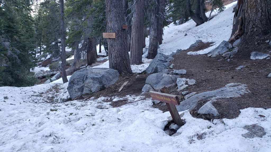
Above and below, examples of work by the Trail Report to restore the route of the PCT north of Strawberry Junction, at about Miles 183.1 and 184.0 respectively, 27th June 2024.The well-known north spring at Wellman’s Cienega (9300 ft) flowing well, 1st July 2024.The small creek in Tahquitz Valley flowing gently where it crosses the meadow trail, 4th July 2024.The creek in Little Round Valley (9750 ft) flowing very well, 2nd July 2024.Stone Creek flowing gently along Deer Springs Trail at about PCT Mile 183.5 (8350 ft), 27th June 2024.The North Fork of the San Jacinto River flowing well where it crosses Fuller Ridge Trail (approx. PCT Mile 186.1) at about 8900 ft, 28th June 2024.
Cooler, seasonal, temperatures on 17th-19th June rapidly transitioned to hot summer temperatures from 21st. Very hot temperatures are forecast for 2nd-8th July, dangerously coinciding with the extended holiday weekend. Overnight low temperatures in particular will be far above seasonal into the second week of July at least. Hikers should be prepared for unseasonably hot weather in the high country, with temperatures above seasonal at all times of day and at all mountain elevations. Give considerable extra thought to start times, route choice, clothing, sun protection, and hydration requirements.
We are already in fire season. Fires – thankfully so far all relatively small – are starting almost daily in the surrounding lowlands of interior Southern California. The first to impact the fringe of the San Jacinto mountains was the Tuscany Fire on 17th June on BLM land on the south side of Chino Canyon (near the Tramway road, north-west Palm Springs), contained at 126 acres.
Survey hikes every day in the San Jacinto mountains include varied routes to San Jacinto Peak multiple times per week (most recently on 21st, 24th, and twice on 28th June) plus many other trails on intervening days. I fully surveyed the northern Desert Divide and associated side trails (PCT Miles 170.5-179) on 18th June.
All major springs, creeks, and pipes are flowing well at this time (example photos below). However flow rates are dropping steadily at upper elevations, many ephemeral water sources are dry, and grassy meadows below 7000 ft are already largely dry. A long, hot, dry summer is forecast.
Campgrounds, forest roads, and fire lookouts all opened in time for the Memorial Day weekend, as described in detail in the previous Report (available here).
Be rattlesnake aware. Southern Pacific Rattlesnakes (Crotalus helleri) have been seen on the trail system up to at least 8800 ft elevation already, and may be seen as high as 9300 ft this month. The volume of sightings suggest abundant snake populations this year in the San Jacinto mountains.
Adult Southern Pacific Rattlesnake at 7750 ft on Marion Mountain Trail, early afternoon 7th June 2024. I nearly trod on this one, seeing the tail just in time as I stepped over this downed tree across the trail (I was descending, right to left in the image). Someone at the State Park has been paying attention; five days after I posted this photo and caption, the tree in question (and another further up the trail) had been cut.
Be bear aware. Although rarely reported, up to three Black Bears have been in the San Jacinto mountains since 2017, where I have seen at least one annually for the past six years, most recently on upper Marion Mountain Trail on 14th September 2023. I found fresh prints in snow on 12th February this year at 9000 ft near PCT Mile 180.5 (photo here). Brief videos from Devil’s Slide Trail in September 2021 (available here) and at home in Idyllwild in 2018 (linked here) show two different individuals. There have been no reports of negative interactions with humans at or near campsites.
WEATHER
Temperatures above average for June are forecast starting 21st and continuing to the end of the month. Forecast temperatures suggest the first two weeks of July will be hot, and well above average for that month on 1st-8th at least. As is increasingly the case with a heating climate in the San Jacinto mountains, overnight low temperatures in particular will be well above seasonal in late June and into July. There is currently no significant new precipitation in the forecasts.
This video forecast from NWS San Diego (linked here) details the forthcoming heat dome, and the current projections for July and the remainder of the summer. Below average precipitation and above average temperatures are predicted, with vegetation moisture content (a key indicator of fire risk) already below average in much of interior Southern California.
At San Jacinto Peak (3295m/10,810ft) on Friday 28th June 2024 at 0715 the air temperature was 52.4°F (11°C), with a windchill temperature of 42.8°F (6°C), 11% relative humidity, and a pleasantly fresh WSW wind sustained at 14 mph gusting to 22.7 mph.
At the Peak on Monday 24th June 2024 at 0800 the air temperature was 56.2°F (13°C), with a “windchill” temperature of 50.8°F (10°C), 76% relative humidity, and a light ESE wind sustained at 5 mph gusting to 10.6 mph.
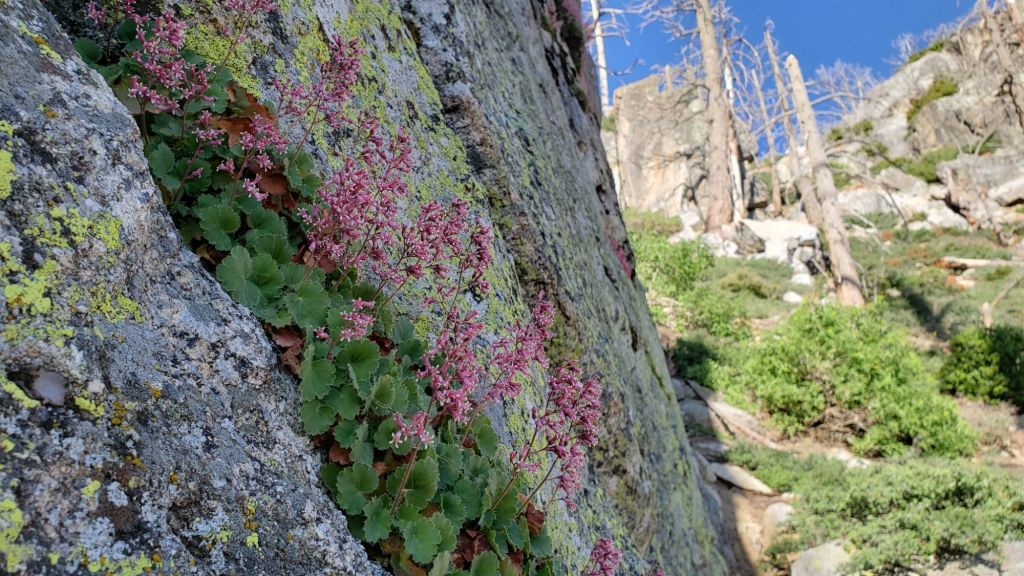
Pink Alumroot (Heuchera rubescens) flowering in a beautiful setting on a near-vertical rock face alongside the PCT on the east side of Antsell Rock, 18th June 2024.
TRAIL CONDITIONS
Snow was gone from the high country trails by mid June.
Trail maintenance has made progress this month, although ultimately less than hoped. An American Conservation Experience (and PCTA-supported) crew worked on Miles 162-165 (south from Fobes Saddle, trimmed plus 17 trees cut), and Miles 177-179 (Tahquitz Creek to Saddle Junction, nine trees cut and tread improved). In mid June several smaller trees were removed from Willow Creek Trail and six trees were cleared from the Little Tahquitz Valley Trail by Forest Service. The Trail Report cleared several trees from the PCT section north of Saddle Junction (Miles 179-181) on 10th June, more than 30 trees from Spitler Peak Trail on 14th, and half-a-dozen more from Deer Springs Trail on 27th.
Deer Springs Trail is clear of snow. About 12 treefall hazards on the trail include 8-9 in the upper trail that have been down and reported repeatedly for years but with no action from the State Park. All but one of the treefall hazards down between Strawberry Junction and the top of Marion Mountain Trail (roughly PCT Miles 183-185) were removed by the Trail Report in late June (example photos below).
The Trail Report cleared this winter’s accumulated treefall hazards from South Ridge Trail in April and has also undertaken extensive trail trimming in the first half of this year.
The 34 treefall hazards that came down across Spitler Peak Trail during ice storms in February 2024 were almost all cleared by the Trail Report on 14th June. The couple of minor stepover branches that remain pose no problem for hikers. This work brings to 120+ the total number of trees removed by the Report from this trail in the past three years. Currently the upper trail in particular is heavily overgrown with lush seasonal vegetation.
Willow Creek Trail is in much more hiker-friendly than this time last year. Several of the smaller trees on the Forest Service section were cut in June. Whitethorn along the trail has not (yet) grown back significantly, other than a couple of minor areas near Hidden Divide in the State Park section. Remaining treefall hazards on the trail include three on the Forest Service section and five on the State Park side (two large ones from last year, plus three small new ones). Unfortunately two of the remaining trees on the Forest Service section are huge (four-plus feet diameter) and some hikers will find them challenging to cross (see photo in previous Report linked here).
The Caramba Trail from near Reeds Meadow through Laws Camp and on to Caramba, and the Cedar Trail from Willow Creek Trail to Laws, are euphemistically described by the Forest Service as “not maintained”. In reality both trails have been abandoned and functionally no longer exist. They are so heavily overgrown with dense whitethorn, which obscures dozens of downed trees, that I strongly advise hikers do not attempt to follow them (regardless of how much you may trust an app). An informaluse trail to Laws is much more direct, maintained, and avoids the challenging bushwhacking of the unmaintained trails (local Idyllwild hikers dubbed it the “King Trail” when I established the route in 2019). It leaves Willow Creek Trail exactly 1.0 mile from Saddle Junction, 0.46 mile from the Skunk Cabbage turning (trailhead at N 33.7796, W 116.6590). The route descends largely following established deer trails for 1.2 miles, meeting Willow Creek about 0.2 mile upstream from the site of the historic Laws Camp (the remains of which were destroyed by the 2013 Mountain Fire and subsequent flood and treefall damage). Eleven trees down on the King Trail were removed in June-July 2023. The tread of the trail received some damage from Tropical Storm Hilary last year. From Laws east to Caramba the route of the original Caramba Trail has been well-cairned by myself and others and can largely be followed with very careful route-finding. My 2023 survey counted about 110 trees down on this 2.1 miles of trail. It is especially obscure for the first 0.3 mile east of the Willow Creek crossing, becoming more obvious (but still subtle) as it descends towards Caramba. Very cautious navigation is advised throughout the area.
Seven Pines Trail is largely (by its formerly low standards) clear of treefall hazards, with about ten down across the trail, most in the central mile, but they are easily passable for hikers. Be advised that the trail in general becomes more obscure in the mile closest to its junction with the PCT. The Trail Report has “adopted” Seven Pines Trail as a priority for maintenance work as the trail has had a disproportionate number of lost hiker rescues in the past decade. Since November 2021, 70 downed trees have been removed and the trail is thoroughly trimmed and cleared regularly (but not yet in 2024). Nevertheless Seven Pines remains a genuine wilderness trail unlike the relatively wide, bare, and obvious routes of, for example, Devil’s Slide or Marion Mountain trails. Cautious navigation remains essential for those without considerable experience of hiking this trail.
Treefall hazards remain a major problem along parts of the Pacific Crest Trail, most notably between Antsell Rock and Red Tahquitz, with 132 recorded in my June 2024 survey between Miles 170.5-175.5. The disinterest of Forest Service and PCTA in maintaining this section of trail for the past five years is unconscionable. A further 15 smaller trees are down from Miles 168.5-170.5 (Spitler Peak Trail to Zen Center Trail). Concentrations of large downed trees make for especially slow-going around Miles 170.5-172 (east side of Antsell Rock) and Miles 174-175 (south and east sides of Red Tahquitz).
The Pacific Crest Trail on the south side of Red Tahquitz (approx. Mile 174.4), 18th June 2024. If it looks like it would be hard to follow the trail, it is, even for those of us very familiar with the route who hike it multiple times per year. Letting any trail, least of all one as internationally famous as the PCT, fall into this state of disrepair seems frankly inexcusable.
The Zen Center Trail continues to deteriorate since the 2013 Mountain Fire, with a combination of vigorous regrowth and treefall hazards further obscuring the route with each passing season. The lower and upper parts of this trail are partially cairned and not too bad for those who are very familiar with the route, but even the experienced find navigating the central section tricky. Long trousers and scrambling gloves are strongly recommended.
While all time and labor is volunteered, the San Jacinto Trail Report uses small private donations to help cover operating costs. Your contribution keeps the Report available to all, free from advertising or paywalls, and independent from agencies. If you have found this Report useful, please consider using this link to the Donate page.Thank you very much for your support.
Above and below, examples of work by the Trail Report to restore the route of the PCT north of Strawberry Junction, at about Miles 183.1 and 184 respectively, 27th June 2024.Spitler Peak Trail, one of the routes “adopted” by the Trail Report due to its importance to PCT hikers as a seasonal safety alternate, has required significant clearing work in recent years following the 2013 Mountain Fire. Above an example of cutting of dead live oak trunks undertaken on 14th June 2024 to keep the trail readily passable.Stone Creek flowing gently along Deer Springs Trail at about PCT Mile 183.5 (8350 ft), 27th June 2024.The well-known north spring at Wellman’s Cienega (9300 ft) flowing well, 17th June 2024.The creek in Little Round Valley (9750 ft) flowing very well, 28th June 2024.The North Fork of the San Jacinto River flowing well where it crosses Fuller Ridge Trail (approx. PCT Mile 186.1) at about 8900 ft, 28th June 2024.The North Fork of the San Jacinto River flowing steadily where it crosses upper Deer Springs Trail at about 9400 ft, 17th June 2024.After a hiatus of a couple of years, which was filled by several short-lived homemade signs, a new State Park sign was placed at the Peak on 15th June 2024. For the first time in many years the name of the mountain is correct, while data from multiple modern technologies suggest that the decades-old official USGS elevation is probably overdue for a new measurement.
Regrettably we are periodically experiencing July-August temperatures in the first half of June. Overnight low temperatures in particular will generally be well above seasonal into late June. Hikers should be prepared for unseasonably warm weather in the high country on most days, with temperatures at or above seasonal at all times of day and at all mountain elevations. Give considerable extra thought to route choice, start times, clothing, sun protection, and hydration requirements.
Prescribed burning actions on Thomas Mountain started on Monday 10th June and are expected to impact access in that area for 7-10 days. Thomas Mountain Road (6S13 to 6S15) and Rouse Ridge Road (5S15) are closed, along with all camping areas on Thomas Mountain. Ramona Trail (3E2) is also closed. Fobes Ranch Road/Quinn Flat is being used for crew staging and as a helicopter base, and may have reduced access.
After years of neglect, there is encouraging news regarding trail maintenance along the PCT on Forest Service lands. An ACE (American Conservation Experience) crew, supported by PCTA, worked last week south from Fobes Saddle, roughly Miles 165-160. Trees were cleared by Forest Service south from Saddle Junction to near Red Tahquitz on 10th-11th June (Miles 179-175), followed by an ACE crew working south from Mile 175 on 12th-18th June down the Desert Divide, the notorious PCT section with 100+ downed trees. The Trail Report cleared several obstructing trees on the PCT section north of Saddle Junction (Miles 179-181) on 10th June, and cut almost all of 35 trees down on Spitler Peak Trail on 14th June.
Snow is gone from the high country trails. Some high elevation areas still hold localized patches (e.g,, north and east flanks of San Jacinto Peak, north side of Jean Peak). Traction devices are no longer required.
Survey hikes every day in the San Jacinto mountains include varied routes to San Jacinto Peak multiple times per week (most recently on 7th, 9th, 10th, and 13th June), Tahquitz Peak and area at least once per week (most recently on 11th June), plus many other trails on intervening days.
All major springs, creeks, and pipes are flowing well at this time. However, flow rates are dropping steadily at upper elevations, many ephemeral water sources are drying, and grassy meadows below 7000 ft are already largely dry. A long, hot summer seems inevitable.
Campgrounds, forest roads, and fire lookouts all opened in time for the Memorial Day weekend, as described in detail in the previous Report (available here).
Be rattlesnake aware. Southern Pacific Rattlesnakes (Crotalus helleri) have been seen on the trail system up to at least 8100 ft elevation already, and may be seen as high as 9300 ft this month. The volume of sightings suggest abundant snake populations this year in the San Jacinto mountains.
Adult Southern Pacific Rattlesnake at 7750 ft on Marion Mountain Trail, early afternoon 7th June 2024. I nearly trod on this one, seeing the tail just in time as I stepped over this downed tree across the trail (I was descending, right to left in the image). Someone at the State Park has been paying attention; five days after I posted this photo and caption, the tree in question (and another further up the trail) had been cut.
WEATHER
Temperatures more typical of midsummer started last week and will persist on some days into mid June (notably on 14th-15th and from 20th onwards). Temperatures will be briefly seasonal (and feel pleasantly cool) on 17th-19th June. As is increasingly the case with a heating climate in the San Jacinto mountains, overnight low temperatures in particular will be above seasonal almost daily into the third week of June. Remaining snow patches will of course disappear rapidly. There is currently no new precipitation in the forecasts.
At San Jacinto Peak (3295m/10,810ft) on Thursday 13th June 2024 at 0750 the air temperature was 46.6°F (8°C), with a windchill temperature of 34.9°F (2°C), 28% relative humidity, and a strong SSW wind sustained at 19 mph gusting to 32.3 mph.
At the Peak on Monday 10th June 2024 at 0800 the air temperature was 54.0°F (12°C), with a “windchill” temperature of 47.3°F (8°C), 18% relative humidity, and a gusty SSE wind sustained at 5 mph gusting to 12.9 mph.
At the Peak on Sunday 9th June 2024 at 0745 the air temperature was 51.3°F (11°C), with a “windchill” temperature of 48.4°F (9°C), 16% relative humidity, and a very light SW breeze sustained at 1 mph gusting to 4.6 mph.
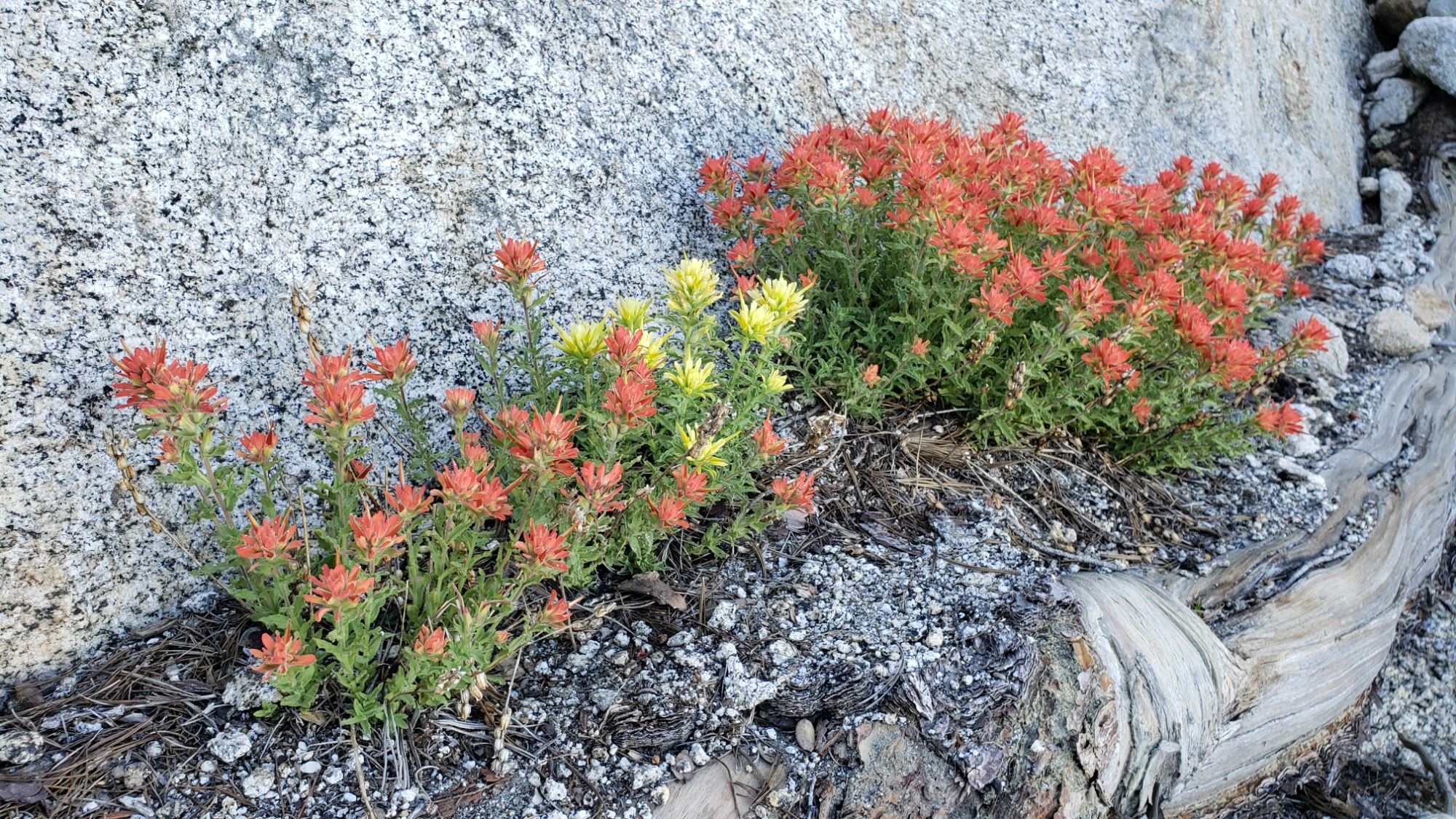
Martin’s Paintbrush (Castilleja applegatei martinii) at 8100 ft on the south flank of Tahquitz Peak, 11th June 2024. Probably the most widespread of several species of “Indian paintbrush” that occur in the San Jacinto mountains. The colored bracts – from which the plants get their common name – are typically bright red, but occasional genetic mutations can produce other colors, such as the yellow plant shown here.
TRAIL CONDITIONS
Trails are clear of snow, with the few tiny remaining patches mentioned below. No notable snow remains below 10,000 ft, and above that elevation only in a handful of less-traveled areas.
South Ridge Trail is clear of snow to Tahquitz Peak. The Trail Report cleared this winter’s accumulated treefall hazards from South Ridge Trail in April and has also undertaken extensive trail trimming in recent months. The notorious 0.4 mile section of South Ridge Trail between Chinquapin Flat/PCT Mile 177 and Tahquitz Peak is now completely clear of snow.
The Peak Trail is clear of snow to its junction with Deer Springs Trail. The area immediately around San Jacinto Peak is now almost entirely snow-free. The East Ridge trail route is now only 10% snow-covered, with the track now largely visible and easy to follow. The Round Valley Trail is now clear of snow.
Deer Springs Trail is clear of snow. The remaining snow patches through and above Little Round Valley have gone in the last few days.
Willow Creek Trail is clear of snow. Overall the trail is in reasonable condition, and certainly far more hiker-friendly than this time last year. Whitethorn along the trail has not (yet) grown back significantly, other than a couple of minor areas near Hidden Divide in the State Park section. Sixteen treefall hazards on the trail include 11 on the Forest Service section (two remaining from last year, plus nine new this winter) and five on the State Park side (two large ones from last year, plus three small new ones). Almost all of the downed trees on the USFS section are north of Willow Creek. Unfortunately two of the hazards on the Forest Service section are huge (four-plus feet diameter) and some hikers will find them challenging to cross (see photo in previous Report linked here).
The Caramba Trail from near Reeds Meadow through Laws Camp and on to Caramba, and the Cedar Trail from Willow Creek Trail to Laws, are euphemistically described by the Forest Service as “not maintained”. In reality both trails have been abandoned and functionally no longer exist. They are so heavily overgrown with dense whitethorn, which obscures dozens of downed trees, that I strongly advise hikers do not attempt to follow them (regardless of how much you may trust an app). An informaluse trail to Laws is much more direct, maintained, and avoids the challenging bushwhacking of the unmaintained trails (local Idyllwild hikers dubbed it the “King Trail” when I established the route in 2019). It leaves Willow Creek Trail exactly 1.0 mile from Saddle Junction, 0.46 mile from the Skunk Cabbage turning (trailhead at N 33.7796, W 116.6590). The route descends largely following established deer trails for 1.2 miles, meeting Willow Creek about 0.2 mile upstream from the site of the historic Laws Camp (the remains of which were destroyed by the 2013 Mountain Fire and subsequent flood and treefall damage). Eleven trees down on the King Trail were removed in June-July 2023. The tread of the trail received some damage from Tropical Storm Hilary last year. From Laws east to Caramba the route of the original Caramba Trail has been well-cairned by myself and others and can largely be followed with very careful route-finding. My 2023 survey counted about 110 trees down on this 2.1 miles of trail. It is especially obscure for the first 0.3 mile east of the Willow Creek crossing, becoming more obvious (but still subtle) as it descends towards Caramba. Very cautious navigation is advised throughout the area.
Seven Pines Trail is largely (by its formerly low standards) clear of treefall hazards, with about ten down across the trail, most in the central mile, but they are easily passable for hikers. Be advised that the trail in general becomes more obscure in the mile closest to its junction with the PCT. The Trail Report has “adopted” Seven Pines Trail as a priority for maintenance work as the trail has had a disproportionate number of lost hiker rescues in the past decade. Since November 2021, 70 downed trees have been removed and the trail is thoroughly trimmed and cleared regularly (but not yet in 2024). Nevertheless Seven Pines remains a genuine wilderness trail unlike the relatively wide, bare, and obvious routes of, for example, Devil’s Slide or Marion Mountain trails. Cautious navigation remains essential for those without considerable experience of hiking this trail.
The 34 treefall hazards that came down across Spitler Peak Trail during ice storms in February 2024 were almost all cleared by the Trail Report in mid June. The couple that remain pose no problem for hikers. Note that the upper trail in particular is currently heavily overgrown with lush seasonal vegetation.
The Pacific Crest Trail is now clear of snow through the San Jacinto mountains. Treefall hazards remain a problem in many places, most notably between Apache Peak and Red Tahquitz, with at least 110 down in my most recent survey. Large downed trees make for especially slow-going around Miles 172-175 (a section severely burned in the July 2013 Mountain Fire). However as described above, significant work is expected in this area in June 2024. A crew is working this week on the PCT south from Fobes Saddle, roughly Miles 160-165. Trees should be cleared by Forest Service south from Saddle Junction early next week (Miles 179-175) and then another crew will be working south from Mile 175 from 12th-18th June. The Trail Report cleared the section north of Saddle Junction (PCT Miles 179-181) on 10th June of several trees across the trail from this past winter.
An example of treefall hazard clearance work undertaken by the Trail Report on a short section of the PCT generally overlooked by the agencies (approx. PCT Mile 180.5), just south of Annie’s Junction, 10th June 2024.
While all time and labor is volunteered, the San Jacinto Trail Report uses small private donations to help cover operating costs. Your contribution keeps the Report available to all, free from advertising or paywalls, and independent from agencies. If you have found this Report useful, please consider using this link to the Donate page.Thank you very much for your support.
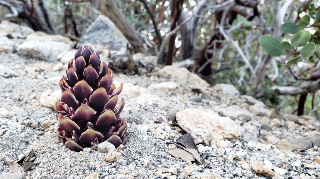
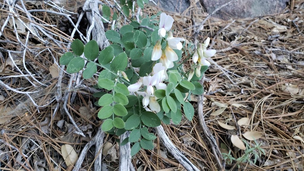
Before you kick that pine cone out of the trail, make sure it isn’t a living plant! The California Groundcone (Kopsiopsis strobilacea) is a parasitic plant that is especially abundant in the San Jacinto mountains this season. As a parasite it has no need for chlorophyll. In our mountains they specialize on parasitizing the roots of manzanita bushes (the leaves to the right of the image) but apparently cause no harm to the host. The image shows the emergent inflorescence, complete with little purplish flowers, that looks remarkably cone-like, photographed at 8300 ft on South Ridge Trail, 29th May 2024.Pacific (or Canyon) Sweet Pea (Lathyrus vestitus), Ernie Maxwell Trail, 3rd June 2024. This species, with the classic sweet pea flower, is native to coastal California including the San Jacinto mountains, in contrast to the widespread introduced European Sweet Pea (Lathyrus latifolius). The latter typically has a much thicker, vine-like growth form, sometimes choking out native vegetation, generally comes in wider variety of colours, and has much larger, longer (not rounded) leaves.
Most hikers will find it is now straightforward to bareboot all of the established trails, including the entire PCT through the San Jacinto mountains. Hikers with limited experience on patchy icy snow may find that carrying spikes remains a good option locally above about 9000 ft. Spikes tend to be particularly useful for descending, especially later in the day as the snow structure deteriorates, even when they generally not required for ascending. Spikes remain recommended for off-trail travel above 10,000 ft.
Daily survey hikes in the San Jacinto mountains include various routes to San Jacinto Peak multiple times per week (most recently on 20th, 24th, 28th May, and 1st June), Tahquitz Peak and area at least once per week (most recently on 25th and 29th May), plus a wide variety of other routes on intervening days.
I am no longer providing snow depth data, as very little snow remains below 10,000 ft. This does not mean there is no snow in the high country, only that it is too patchy to give meaningful measurements (see photos below). Some high elevation areas still hold 1-2 feet of increasingly patchy snow (e.g,, Little Round Valley, east flank of San Jacinto Peak, north side of Jean Peak)
All major springs, creeks, and pipes (and many ephemeral ones too) are flowing well at this time (example photo below). Flow rates are dropping rapidly however – Middle Spring on Devil’s Slide Trail is already down to just 25% of its early May flow – and a long, hot summer is provisionally forecast (e.g., see NWS San Diego discussion linked here).
Campgrounds reopened in time for the Memorial Day weekend. Black Mountain Road reopened for the season on Wednesday 22nd May. The boulder in the road about 0.5 mile above that gate was removed last week, and Pinewood residents graded the lower 1.7 miles of the road on 18th May. The entire road is clear of snow.
Dark Canyon Road had been closed almost continuously since February 2019, but reopened on 24th May for the summer. Black Mountain fire lookout reopened on 19th May, and Tahquitz Peak fire lookout on 26th May. South Ridge Road reopened for the season on 23rd April. Due to a localized section of mud, the uppermost road is currently best suited to high clearance AWD/4WD vehicles.
Be rattlesnake aware. Southern Pacific Rattlesnakes (Crotalus helleri) have been seen on the trail system up to at least 8100 ft elevation already. The volume of reports and sightings suggest abundant snake populations this year in the San Jacinto mountains. Rattlesnakes will get increasingly active with warmer weather and may be seen anywhere up to about 9300 ft by the end of May.
The Round Valley pipe (9100 ft) flowing very well, 28th May 2024.
WEATHER
Seasonal temperatures in recent days will soon be replaced by hot weather and temperatures more typical of July-August than for late May/early June, starting on Thursday 30th May. Temperatures will be above even midsummer averages on 5th-6th June at least. As is increasingly the case in a heating climate in the San Jacinto mountains, overnight low temperatures in particular will be far above seasonal well into the first week of June. What little snow remains will of course melt rapidly. There is currently no significant precipitation in the forecasts.
At San Jacinto Peak (3295m/10,810ft) on Tuesday 28th May 2024 at 0740 the air temperature was 47.2°F (8°C), with a windchill temperature of 41.0°F (5°C), 13% relative humidity, and a light due South wind sustained at 4 mph gusting to 10.3 mph.
At the Peak on Friday 24th May 2024 at 0800 the air temperature was 35.4°F (2°C), with a windchill temperature of 21.6°F (-6°C), 37% relative humidity, and a fresh due West wind sustained at 16 mph gusting to 22.6 mph.
A field of “suncups” at about 10,600 ft on the East Ridge of San Jacinto Peak, 28th May 2024. Subtle unevenness in the snow surface becomes greatly exaggerated with differential melting, forming this feature that does not make for particularly easy hiking.
TRAIL CONDITIONS
Except where discussed below, trails are clear of snow. All trails below 8000 ft are now clear of snow. Notable snow remains below 9000 ft only in a few sheltered areas. Sun-exposed trails as high as San Jacinto Peak are now largely clear of snow, especially on the Peak’s south flank. Tracks through the remaining snow patches remain hard and icy in places early in the morning, but soften quickly by mid morning, getting sloppy as early as midday.
South Ridge Trail is clear of snow to Tahquitz Peak on its south approach. The Trail Report cleared this winter’s accumulated treefall hazards from South Ridge Trail in April and has also undertaken extensive trail trimming in recent months. The 0.4 mile section of South Ridge Trail between Chinquapin Flat/PCT Mile 177 and Tahquitz Peak is now functionally clear of snow. A couple of remaining tiny snow patches are easy to hike around.
Devil’s Slide Trail is clear of snow. The Trail Report has undertaken extensive trail maintenance work since February to remove many tree limbs in and over the trail damaged by ice storms this winter.
The Peak Trail is now functionally clear of snow to its junction with Deer Springs Trail at 10,500 ft, but a few areas of limited snow patches remain. As usual the most persistent sections of snow patches remain around 9900-10,100 ft, and then above 10,400 ft. The area immediately around San Jacinto Peak is still largely snow-covered on the east approach, but snow-free on the south side. The East Ridge trail route remains 80% snow-covered, and the track is increasingly riddled with suncups (photo above).
Wellman Trail is now clear of snow where it is outside of forest cover, with only patchy 20% snow cover on the forested first 0.25 mile north of Annie’s Junction (the Forest/State Park boundary).
The Round Valley Trail averages only 10% snow cover in its uppermost section, within 0.3 mile of Wellman Divide. The remainder of the trail is clear of snow.
Deer Springs Trail is now functionally clear of snow to its junction with the Peak Trail at 10,500 ft. Snow cover averages only 5% on the trail above 8700 ft (the Marion Mountain Trail junction). In Little Round Valley snow cover averages 30% but is declining daily, and the drifts pose no navigation or traction issues. From the upper end of Little Round Valley to San Jacinto Peak snow cover is now only 10% with most of the trail exposed. Spikes are generally no longer required but some hikers may find them helpful, along with cautious navigation.
Willow Creek Trail is clear of snow. Overall the trail is in reasonable condition, and certainly far more hiker-friendly than this time last year. Whitethorn along the trail has not (yet) grown back significantly, other than a couple of minor areas near Hidden Divide in the State Park section. Sixteen treefall hazards on the trail include 11 on the Forest Service section (two remaining from last year, plus nine new this winter) and five on the State Park side (two large ones from last year, plus three small new ones). Almost all of the downed trees on the USFS section are north of Willow Creek. Unfortunately two of the hazards on the Forest Service section are huge (four-plus feet diameter) and some hikers will find them challenging to cross.
Huge treefall hazard on the USFS section of Willow Creek Trail, new this past winter, photographed 28th May 2024. Some conveniently placed side branches make this easier to cross than another even larger tree down about 0.6 mile further north.
Spitler Peak Trail suffered badly during ice storms in early February, and I found 34 new treefall hazards down during my surveys in late winter, almost all in the upper half. Most are relatively small and readily passable, but a few are larger, and the combined effect is to make for a slower and scrappier hike.
The Caramba Trail from near Reeds Meadow through Laws Camp and on to Caramba, and the Cedar Trail from Willow Creek Trail to Laws, are euphemistically described by the Forest Service as “not maintained”. In reality both trails have been abandoned and functionally no longer exist. They are so heavily overgrown with dense whitethorn, which obscures dozens of downed trees, that I strongly advise hikers do not attempt to follow them (regardless of how much you may trust an app). An informaluse trail to Laws is much more direct, well maintained, and avoids the challenging bushwhacking of the unmaintained trails (local Idyllwild hikers dubbed it the “King Trail” when I established the route in 2019). It leaves Willow Creek Trail exactly 1.0 mile from Saddle Junction, 0.46 mile from the Skunk Cabbage turning (trailhead at lat/long N 33.7796, W 116.6590). The route descends largely following established deer trails for 1.2 miles, meeting Willow Creek about 0.2 mile upstream from the site of the historic Laws Camp (the remains of which were destroyed by the 2013 Mountain Fire and subsequent flood and treefall damage). The 11 trees down on the King Trail were removed in June-July 2023. The tread of the trail received some minor damage from Tropical Storm Hilary last year. From Laws east to Caramba the route of the original Caramba Trail has been well-cairned by myself and others and can largely be followed with very careful route-finding. My August 2023 survey counted about 110 trees down on this 2.1 miles of trail. It is especially obscure for the first 0.3 mile east of the Willow Creek crossing, becoming more obvious (but still subtle) as it descends towards Caramba. Very cautious navigation is advised throughout the area.
Seven Pines Trail is largely (by its formerly low standards) clear of treefall hazards, with about ten down across the trail, most in the central mile, but they are easily passable for hikers. A few extended snow patches remain near the junction with Deer Springs Trail. Be advised that the trail in general becomes more obscure in the mile closest to its junction with the PCT. The Trail Report has “adopted” Seven Pines Trail as a priority for maintenance work as the trail has had a disproportionate number of lost hiker rescues in the past decade. Since November 2021, about 70 downed trees have been removed and the trail is thoroughly trimmed and cleared regularly (but not yet in 2024). Nevertheless Seven Pines remains a genuine wilderness trail unlike the relatively wide, bare, and obvious routes of, for example, Devil’s Slide or Marion Mountain trails. Cautious navigation remains essential for those without considerable experience of hiking this trail.
On the PCT treefall hazards remain a problem in many places, most notably between Apache Peak and Red Tahquitz, with at least 110 down in my most recent survey. Large downed trees make for especially slow-going around Miles 172-175 (a section severely burned in the July 2013 Mountain Fire).
The Pacific Crest Trail is now largely clear of snow through the San Jacinto mountains, but hikers less experienced with patchy icy snow may continue to find spikes useful for a few more days. The trail is clear from Miles 151 (Highway 74) to about 174.5. The track on the north side of Red Tahquitz (Miles 175-177) has some persistent snow patches averaging 20% snow cover. The trail is functionally clear of snow to Mile 184.5, with a few snow patches through the sheltered forest at Miles 180-181. The frequency of snow patches is higher, but no longer problematic, between Miles 184.5-190. A few short sections average about 30% snow cover.Large sections of Fuller Ridge Trail are now clear. Traversing this section is now straightforward barebooting but carrying spikes will continue to be preferred by some hikers.
While all time and labor is volunteered, the San Jacinto Trail Report uses small private donations to help cover operating costs. Your contribution keeps the Report available to all, free from advertising or paywalls, and independent from agencies. If you have found this Report useful, please consider using this link to the Donate page.Thank you very much for your support.
Cornus nuttallii, commonly known as Pacific or Mountain Dogwood, in full bloom on Dark Canyon Road, 27th May 2024. This species is highly localized in the San Jacinto mountains, but at least 20 trees flourish in the cool, damp drainages in this area.Upper Little Round Valley (9800 ft), 24th May 2024, with a rough average of six inches of snow remaining. However as shown here snow depth varies greatly due to past drifting and differential melting, with extensive bare patches alternating with drifts from 1-3 feet deep.PCT Mile 185.5, the junction of Fuller Ridge Trail (left) with Deer Springs Trail (right), illustrating recent rapid snowmelt. Above, mid morning 24th May 2024, and below, two weeks earlier on 10th May 2024.
Snowmelt has been very rapid in the past week with temperatures generally above seasonal. It is now possible to bareboot all of the established trails, including the entire PCT through the San Jacinto mountains. However for many hikers carrying spikes remains a good option above about 8500 ft. Spikes tend to be particularly useful for descending, especially later in the day as the snow structure deteriorates, even when they generally not required for ascending.
Daily survey hikes in the San Jacinto mountains include various routes to San Jacinto Peak multiple times per week (most recently on 13th, 17th, 20th, and 24th May), Tahquitz Peak and area at least once per week (most recently on 19th May), plus a wide variety of other trails on intervening days.
I am no longer providing snow depth data, as very little snow remains below 9000 ft. Please note that this does not mean there is no snow in the high country, only that it is generally too patchy to give meaningful measurements (see photos below). Indeed some sheltered high elevation areas (e.g,, Little Round Valley) still hold pockets with 2-3 feet of snow.
At this time I am not providing detailed updates on water sources, as all major springs, creeks, and pipes (and many ephemeral ones too) are flowing well and reliably. Flow rates are dropping rapidly however – Middle Spring on Devil’s Slide Trail is already down to just 25% of its early May flow – and a long, hot summer is provisionally forecast (see NWS San Diego discussion linked here).
All campgrounds reopened in time for the Memorial Day weekend. Black Mountain Road reopened for the season on Wednesday 22nd May. The boulder in the road about 0.5 mile above that gate was removed last week, and Pinewood residents graded the lower 1.7 miles of the road on 18th May. The entire road is clear of snow.
South Ridge Road reopened for the season on 23rd April. Due to a localized section of mud, the uppermost road is currently best suited to high clearance AWD/4WD vehicles. Dark Canyon Road has been closed almost continuously since February 2019, but reopened on 24th May for the summer. Black Mountain fire lookout reopened on 19th May, and Tahquitz Peak fire lookout will reopen on 26th May.
Be rattlesnake aware. Southern Pacific Rattlesnakes (Crotalus helleri) have been seen on the trail system up to at least 7100 ft elevation already. Initial sightings suggest abundant snake populations this year in the San Jacinto mountains. Rattlesnakes will get increasingly active with warmer weather next week and may be seen anywhere up to about 9300 ft by the end of May.
Adult Southern Pacific Rattlesnake, Marion Mountain Trail at 7100 ft, early morning on 17th May 2024. This is very rarely how hikers will encounter rattlesnakes, where the snake has used its body to “dig” a bowl in which to spend the night. This is only the second time I have found a rattlesnake “roosting” in the open adjacent to a trail in the San Jacinto mountains. When I descended a few hours later, the snake was still in the same location, likely waiting to warm up in some direct sunlight.
WEATHER
Temperatures will be near (or even slightly below) seasonal until Sunday 26th May, before again rising to well above seasonal starting around Monday 27th. Snowmelt will be steady and widespread, before accelerating rapidly next week. There is currently no significant precipitation in the forecasts.
At San Jacinto Peak (3295m/10,810ft) on Friday 24th May 2024 at 0800 the air temperature was 35.4°F (2°C), with a windchill temperature of 21.6°F (-6°C), 37% relative humidity, and a fresh due West wind sustained at 16 mph gusting to 22.6 mph.
At the Peak on Monday 20th May 2024 at 0755 the air temperature was 31.9°F (0°C), with a windchill temperature of 16.2°F (-9°C), 28% relative humidity, and a stiff due West wind sustained at 18 mph gusting to 26.2 mph.
TRAIL CONDITIONS
Snowmelt has continued to be very rapid in the past week. Trails below 8000 ft are now clear of snow. Significant snow remains below 9000 ft only in sheltered areas. Sun-exposed trails up to 10,500 ft are now largely clear of snow. Clear patches are increasing as high as San Jacinto Peak, especially on the south flank.
Snow quality has deteriorated with warmer weather in recent weeks. Tracks can still be hard and icy in places especially early morning, but then soften quickly by mid morning, getting sloppy as early as midday.
Carrying spikes remains a good option for most hikers everywhere above about 8500 ft. Icy compacted snow – following many freeze-thaw cycles and now that most trails have been well-traveled – is largely ideal for spikes. Snowshoes are no longer recommended anywhere, and are at best of very limited use away from compacted tracks above about 10,000 ft elevation on warm days later in the day on sunny slopes. I see no recent evidence of hikers using snowshoes anywhere on the mountain.
Devil’s Slide Trail is clear of snow to Saddle Junction. The Trail Report has undertaken extensive trail maintenance work since February to remove many tree limbs in and over the trail damaged by ice storms this winter.
South Ridge Trail (on the south side) is clear of snow to Tahquitz Peak. The Trail Report cleared this winter’s accumulated treefall hazards from South Ridge Trail in April and has also undertaken extensive trail trimming in the past month.
The 0.4 mile section of South Ridge Trail between Chinquapin Flat/PCT Mile 177 and Tahquitz Peakis largely clear andhas an adequate track to follow through the remaining small icy snow patches at this time [surveyed 20th May]. In many places it is possible to hike around remnant snow patches on adjacent rocks. Most hikers will find that spikes are not required, but it is best to turn around if you are not comfortable traversing this type of exposed terrain.
The Peak Trail is now largely clear of snow. As usual the most persistent lengthy sections of snow remain around 9900-10,100 ft elevation. Where there is a snow track it roughly follows the true trail route. The most heavily-traveled track above 10,400 ft now follows the true Peak Trail route through very sparse snow patches. The area immediately around San Jacinto Peak is still largely snow-covered on the east approach. The East Ridge trail route remains 95% snow-covered, and is increasingly lumpy (due to melting) and unclear (as most hikers now use the Peak Trail proper).
Wellman Trail is now clear of snow where it is outside of forest cover, with only patchy 60% snow cover on the forested first 0.25 mile north of Annie’s Junction.
Deer Springs Trail is clear of snow to Strawberry Junction. Above Strawberry Junction snow cover is now very sparse (averaging only 20%) to the Marion Mountain Trail junction. A well-traveled but largely uneven posthole track, that does not accurately follow the trail route in places, continues through about 40% snow cover thereafter. Above the Fuller Ridge Trail junction (8900 ft) the trail is largely clear and snow cover is now only averages 10%. However in sheltered sections at 9300-9600 ft the track(s) are a mess in places, only roughly following the trail route, and at times diverging into two or even three options. There are places where more than one track passes through Little Round Valley, where snow cover averages 50%. From the upper end of Little Round Valley to San Jacinto Peak snow cover is now only 10% with most of the trail exposed. However in the central part of this section (roughly 10,100-10,300 ft) the icy drifts are more continuous and the trail is obscure in places. Spikes are generally no longer required but some hikers will find them helpful, along with cautious navigation.
Marion Mountain Trail is clear of snow. A couple of tiny icy snow patches remain close to the Deer Springs/PCT junction. Spikes no longer required.
The State Park section of Skyline Trail reopened on Tuesday 7th May. The trail is clear of ice and spikes are not required.
Spitler Peak Trail suffered badly during ice storms in early February, and I found 34 new treefall hazards down during my surveys in late winter, almost all in the upper half. Most are relatively small and readily passable, but a few are larger, and the combined effect is to make for a slower and scrappier hike.
On the PCT treefall hazards remain a problem in many places, most notably between Apache Peak and Red Tahquitz, with at least 110 down in my most recent survey. Large downed trees make for especially slow-going around Miles 172-175 (a section severely burned in the July 2013 Mountain Fire).
The Caramba Trail from near Reeds Meadow through Laws Camp and on to Caramba, and the Cedar Trail from Willow Creek Trail to Laws, are euphemistically described by the Forest Service as “not maintained”. In reality both trails have been abandoned and functionally no longer exist. They are so heavily overgrown with dense whitethorn, which obscures dozens of downed trees, that I strongly advise hikers do not attempt to follow them (regardless of how much you may trust a certain app). An informaluse trail to Laws is much more direct, well maintained, and avoids the challenging bushwhacking of the unmaintained trails (local Idyllwild hikers dubbed it the “King Trail” when I established the route in 2019). It leaves Willow Creek Trail exactly 1.0 mile from Saddle Junction, 0.46 mile from the Skunk Cabbage turning (trailhead at lat/long N 33.7796, W 116.6590). The route descends largely following established deer trails for 1.2 miles, meeting Willow Creek about 0.2 mile upstream from the site of the historic Laws Camp (the remains of which were destroyed by the 2013 Mountain Fire and subsequent flood and treefall damage). The 11 trees down on the King Trail after this winter were removed in June-July 2023. The tread of the trail received some minor damage from Tropical Storm Hilary. From Laws east to Caramba the route of the original Caramba Trail has been well-cairned by myself and others and can largely be followed with very careful route-finding. My August 2023 survey counted about 110 trees down on this 2.1 miles of trail. It is especially obscure for the first 0.3 mile east of the Willow Creek crossing, becoming more obvious (but still subtle) as it descends towards Caramba. Very cautious navigation is advised throughout the area.
Seven Pines Trail is largely (by its low standards) clear of treefall hazards, with about ten down across the trail, most in the central mile, but they are easily passable for hikers. Be advised that the trail in general becomes more obscure in the mile closest to its junction with the PCT. The Trail Report has “adopted” Seven Pines Trail as a priority for maintenance work as the trail has had a disproportionate number of lost hiker rescues in the past decade. Since November 2021, about 70 downed trees have been removed and the trail is thoroughly trimmed and cleared regularly (but not yet in 2024). Nevertheless Seven Pines remains a genuine wilderness trail unlike the relatively wide, bare, and obvious routes of, for example, Devil’s Slide or Marion Mountain trails. Cautious navigation remains essential for those without considerable experience of hiking this trail.
PACIFIC CREST TRAIL
The PCT is now largely clear of snow through the San Jacinto mountains, but hikers less experienced with patchy icy snow will continue to find spikes useful.
The trail is clear from Miles 151 (Highway 74) to about 174.5. A handful of tiny patches remain on some north-facing slopes. Apache Peak (Mile 169.5) is now clear of snow.
The track on the north side of Red Tahquitz (Miles 175-177) does not accurately follow the PCT route in a few minor places, through an average of 30% snow cover. Snow cover declines to only about 10% between Miles 178-179. The south-facing slopes at Miles 179-180.3 and 181-183 are now clear of snow, with the exception of a handful of tiny patches.
Snow cover is then locally significant, but with snow-free patches increasing every day, between Miles 184.5-190. There is a well-traveled and reliable posthole track to follow on the remaining snow-covered sections of Fuller Ridge (Miles 185.5-191), averaging about 40% snow cover. Large sections of this trail, especially on top of the ridge and on south- and west-facing slopes, are now clear. Although the posthole track does not always accurately the PCT route in places, following the main track is the safest way to traverse these miles. Traversing this section is now possible barebooting but carrying spikes will continue to be preferred by some hikers.
Hikers wanting to avoid Fuller Ridgecan use the Black Mountain Road alternate. Black Mountain Road is open to hikers but not to vehicle traffic at this time. Spikes are not required on Black Mountain Road.
On the PCT treefall hazards remain a problem in many places, most notably between Apache Peak and Red Tahquitz, with at least 110 down in my most recent survey. Large downed trees make for especially slow-going around Miles 172-175 (a section severely burned in the July 2013 Mountain Fire).
PCT hikers are politely reminded that overnight stays are not permitted at or near San Jacinto Peak, including in the historic shelter. Mt. San Jacinto State Park regulations do not permit overnight stays in the shelter, which is dedicated for emergency, SAR, and ranger use.
While all time and labor is volunteered, the San Jacinto Trail Report uses small private donations to help cover operating costs. Your contribution keeps the Report available to all, free from advertising or paywalls, and independent from agencies. If you have found this Report useful, please consider using this link to the Donate page.Thank you very much for your support.
The Peak Trail at 9800 ft elevation north of Wellman Divide. Above, on 20th May 2024, and for comparison the same view one year earlier on 19th May 2023, when an average of about two feet of snow remained at that elevation even on such a sun-exposed slope.Upper Little Round Valley (9800 ft), 24th May 2024, with a rough average of 6-12 inches of snow remaining. However as shown here snow depth varies greatly due to past drifting and differential melting, with extensive bare patches alternating with drifts as much as 2-3 feet deep.PCT Mile 185.5, the junction of Fuller Ridge Trail (left) with Deer Springs Trail (right), illustrating recent rapid snowmelt. Above, mid morning 24th May 2024, and below, two weeks earlier on 10th May 2024.
UPDATE Sunday 19th May 2024: the 0.4 mile section of South Ridge Trail on the north side of Tahquitz Peak is now largely clear of snow. Although some icy snow patches remain there are well-defined steps to follow, or it is possible to hike around the patches on adjacent rocks. Most hikers will find that they no longer require spikes on this trail.
Above seasonal temperatures in recent days have greatly accelerated snowmelt. It is now possible to bareboot almost all of the established trail routes, including the entire PCT through the San Jacinto mountains. However, that option is recommended only for those experienced hiking on unevenly distributed icy snow and using appropriate footwear. For many hikers, carrying spikes remains useful everywhere above about 8500 ft.Spikes tend to be particularly useful for descending, especially later in the day as the snow structure deteriorates, even when they not required for ascending.
Daily survey hikes in the San Jacinto mountains include various routes to San Jacinto Peak multiple times per week (most recently on 10th, 13th, and 17th May), Tahquitz Peak and area at least once per week (most recently on 12th and 19th May), plus a wide variety of other trails on intervening days.
Details of snow depths measured at various locations on the trail system are given at the foot of this posting. Note however that snow depth itself is very rarely indicative of the difficulty (or ease) of hiking a particular track or trail. For example a well-traveled and defined track across deep snow is often much easier hiking than a lightly traveled track across shallow, angled, icy snow.
Black Mountain Road remains closed to vehicle trafficdue to winter conditions at the gate 1.7 miles up from Highway 243, but is scheduled to reopen on Thursday 23rd May. The boulder in the road about 0.5 mile above that gate was removed this week. The road is clear of snow to Fuller Ridge campground. Black Mountain fire lookout is scheduled to reopen on 18th May and Tahquitz Peak fire lookout on 26th May.
South Ridge Road reopened for the season on 23rd April. Due to a localized section of deep mud, the uppermost road is currently best suited to high clearance AWD/4WD vehicles. Dark Canyon Road has been closed almost continuously for five years, but is expected to reopen in late May 2024.
Be rattlesnake aware. Southern Pacific Rattlesnakes (Crotalus helleri) have emerged even at the upper end of their elevational distribution and have been seen on the trail system up to at least 7100 ft elevation already. Initial sightings suggest an abundant rattlesnake population this year. They will get increasingly active with warmer weather and may be seen anywhere up to about 9300 ft by the end of May.
Adult Southern Pacific Rattlesnake about one metre long, Marion Mountain Trail at 6500 ft (just above the campground), late morning on 10th May 2024. This is typically how hikers will encounter rattlesnakes, sunning in the trail. I measured the air temperature here at only 55°F and this individual was predictably sluggish.
WEATHER
Temperatures remain above seasonal for May for at least the next week, and especially warm on 16th-19th. Temperatures then drop to about average for late May from Monday 20th. Snowmelt will be rapid and widespread. There is no currently no significant precipitation in the forecasts.
NWS San Diego data (linked here) indicates that rainfall in Idyllwild is at 77% of average so far this water year. My provisional data indicate snowfall in Idyllwild has been about 85% of seasonal, but well below average (c.65%) at San Jacinto Peak.
At San Jacinto Peak (3295m/10,810ft) on Friday 17th May 2024 at 0750 the air temperature was 41.6°F (5°C), with a windchill temperature of 33.1°F (1°C), 32% relative humidity, and a steady due West wind sustained at 8 mph gusting to 11.5 mph.
At the Peak on Monday 13th May 2024 at 0750 the air temperature was 44.5°F (7°C), with a windchill temperature of 35.2°F (2°C), 32% relative humidity, and a light SE wind sustained at 6 mph gusting to 10.3 mph.
At the Peak on Friday 10th May 2024 at 0745 the air temperature was 37.0°F (3°C), with no measurable windchill temperature, 56% relative humidity, and essentially calm conditions.
TRAIL CONDITIONS
Snowmelt has continued to be very rapid in the past week. Trails below 8000 ft are now generally clear of snow. Sun-exposed trails up to 9700 ft are now largely clear of snow (e.g., PCT Miles 179-184.5 from Saddle Junction north to near the top of Marion Mountain Trail). Significant snow-free sections of trails as high as 10,400 ft are increasing every day, notably on the sun-exposed eastern side Peak Trail. A few tiny clear patches are even appearing up to 10,700 ft near San Jacinto Peak.
Snow quality has deteriorated with warmer weather in recent weeks. Tracks have largely consolidated due to freeze-thaw cycles and hiker traffic, and can still be hard and icy in places especially early morning, but then soften quickly by mid morning, getting sloppy as early as midday.
Carrying spikes remains useful for most hikers everywhere above about 8000 ft. Icy compacted snow – following many freeze-thaw cycles and now that most trails have been well-traveled – is largely ideal for spikes.
The State Park section of Skyline Trail reopened on Tuesday 7th May. The trail is clear of ice and spikes are not required.
Devil’s Slide Trail is now clear of snow to Saddle Junction. A few tiny icy snow patches remain very close to the Saddle. The Trail Report has undertaken extensive trail maintenance work since February to remove many tree limbs in and over the trail damaged by ice storms this winter.
South Ridge Trail is now clear of snow to Tahquitz Peak. The Trail Report cleared this winter’s accumulated treefall hazards from South Ridge Trail in April and has also undertaken extensive trail trimming in April-May.
The 0.4 mile section of South Ridge Trail between Chinquapin Flat/PCT Mile 177 and Tahquitz Peak has an adequate track to follow through the few remaining small icy snow patches at this time [most recently surveyed 20th May]. Most hikers will find that spikes are not required, but it is best to turn around if you are not comfortable traversing this type of exposed terrain.
The Peak Trail is now largely clear of snow for the 0.5 mile north of Wellman Divide. The snow track has been well-traveled, fairly accurately follows the true trail route, and already has a few short snow-free patches developing to 10,500 ft. The most heavily-traveled track above 10,400 ft now follows the true Peak Trail route, while a completely snow-covered track ascends directly up the East Ridge route.
Wellman Trail is now clear of snow for most of its length where it is outside of forest cover, with only patchy snow on the forested first 0.25 mile north of Annie’s Junction.
Deer Springs Trail is clear of snow to Strawberry Junction. Above Strawberry Junction snow cover is now very sparse to about 8500 ft, within 0.25 mile of the junction with Marion Mountain Trail. A well-traveled but largely uneven posthole track, that does not accurately follow the trail route in many places, continues through about 70% snow cover thereafter. Above the Fuller Ridge Trail junction (8900 ft) snow cover is now only averages 20% on the sun-exposed slopes until 9300 ft. The track(s) are a mess above that elevation, only roughly following the trail route, and at times diverging into two or even three options, through an average of 70% snow cover. All of the tracks ultimately get to Little Round Valley however. The tracks largely coalesce through Little Round Valley where snow cover is 75%. From the upper end of Little Round Valley to San Jacinto Peak snow cover is now only 60% and lengthy sections of the trail are exposed, especially in the upper 0.5 mile. There are several moderately-traveled posthole tracks that meander up the slope, with none accurately following the true trail route. Spikes are no longer required but can be helpful, especially for descending the upper trail, along with cautious navigation.
Marion Mountain Trail is almost entirely clear of snow. A handful of small icy snow patches remain close to the Deer Springs/PCT junction. Spikes are generally no longer required.
Spitler Peak Trail suffered badly during ice storms in early February, and I found 34 new treefall hazards down during my surveys in late winter, almost all in the upper half. Most are relatively small and readily passable, but a few are larger, and the combined effect is to make for a slower and scrappier hike.
PACIFIC CREST TRAIL
The PCT is clear of snow from Miles 151 (Highway 74) to about 174.5. A handful of tiny patches remain on some north-facing slopes. Apache Peak (Mile 169.5) is now functionally clear of snow.
The posthole track on the north side of Red Tahquitz (Miles 175-177) does not accurately follow the PCT route in places, through an average of 50% snow cover. Snow cover declines to only about 20% between Miles 178-179. The south-facing slopes at Miles 179-180.3 and 181-183 are now clear of snow, with the exception of a handful of tiny patches.
Snow cover is then significant, but with snow-free patches increasing every day, between Miles 184.5-190. There is a well-traveled and reliable posthole track to follow on the remaining snow-covered sections of Fuller Ridge (Miles 185.5-191). Large sections of this trail, especially on top of the ridge and on south- and west-facing slopes, are now clear. Although the posthole track does not always accurately the PCT route in places, following the main track is the safest way to traverse these miles. Traversing this section is possible barebooting but carrying spikes will continue to be preferred by most hikers.
Some PCT hikers are continuing to report that Fuller Ridge is challenging for those who are not experienced with icy snow travel. Hikers wanting to avoid Fuller Ridgecan use the Black Mountain Road alternate. Black Mountain Road is open to hikers but not to vehicle traffic at this time. Spikes are not required on Black Mountain Road.
PCT hikers are politely reminded that overnight stays are not permitted at or near San Jacinto Peak, including in the historic shelter. Mt. San Jacinto State Park regulations do not permit overnight stays in the shelter, which is dedicated for emergency, SAR, and ranger use.
While all time and labor is volunteered, the San Jacinto Trail Report uses small private donations to help cover operating costs. Your contribution keeps the Report available to all, free from advertising or paywalls, and independent from agencies. If you have found this Report useful, please consider using this link to the Donate page.Thank you very much for your support.
Saddle Junction (8100 ft, approx. PCT Mile 179), early morning Monday 13th May 2024, with snow cover now very limited.
SNOW DEPTHS measured on 13th May 2024 (unless otherwise indicated) are as follows. The first number gives current average total depth, which also accounts for substantial melting between and since winter storms. The number in brackets is the greatest depth at that location this winter (where known). Note that averages are given; due to strong winds during and after most storms there has been considerable drifting, plus often very uneven melting during warm interludes. Altitudes and PCT mileages are approximate.
San Jacinto Peak (10810 ft): 18 inches, ranging from 0-40 inches [60 inches on 1st April]
Little Round Valley (9800 ft): 24 inches, ranging from 0-50 inches, measured 10th May
Wellman Divide (9700 ft): 0 inches, ranging from 0-10 [41-43 inches on 8th February], photos below
Annie’s Junction/approx. PCT Mile 181.8 (9070 ft): 11 inches, ranging from 0-22 [55 inches on 1st April]
Seven Pines Trail junction with Deer Springs Trail/PCT Mile 184.9(8650 ft): 4 inches, measured 10th May
Long Valley (8400 ft): 0 inch [24 inches on 8th February]
Strawberry Junction/PCT Mile 183 (8100 ft): 0 inch
Saddle Junction/PCT Mile 179.9 (8070 ft): 0 inch, isolated drifts up to 8 inches [32 inches on 1st April]
Devil’s Slide Trail at Humber Park (6550 ft): 0 inch [15 inches on 8th February]
Idyllwild (at 5550 ft): 0 inch [9 inches on 8th February]
Above and below, Wellman Divide (9700 ft), where the Wellman, Round Valley, and Peak trails meet. Above, late morning on 6th May 2024. Below, the same view the previous year on 11th May 2023, when 3-5 feet of snow persisted at that elevation, demonstrating what an historically average snow year should look like (the only one we have experienced in the past 12+ years).PCT Mile 185.5, the junction of Fuller Ridge Trail (left) with Deer Springs Trail (right), early morning 10th May 2024.Upper Little Round Valley (9800 ft), 10th May 2024, with an average of about two feet of snow remaining, but as can be seen snow depth varies greatly due to past drifting and differential melting.Adult Southern Pacific Rattlesnake, Marion Mountain Trail at 6500 ft (just above the campground), late morning on 10th May 2024. The same individual as shown above, after I had gently encouraged it to move off the trail.The trash that I found and packed down from my hike to San Jacinto Peak on 10th May 2024. More rubbish than an average day for me, but considering that I hike to the Peak multiple times per week, it is certainly not months (or even weeks) worth of accumulation.
UPDATE Wednesday 8th May: the State Park section of Skyline Trail has reopened. The trail is clear of ice and spikes are not required.
I had a delightful hike to San Jacinto Peak early morning Sunday 5th through our 28th storm of winter 2023/24. We only caught the southernmost edge of a more significant system moving through further north and the storm was yet again very minor in terms of precipitation. Light rain started in the early hours and stopped by about 0830. The storm was (relatively) mild and freezing rain plastered the vegetation and rocks as high as 10,100 ft. Although very fine powder dusted down to 9800 ft, there was a barely measurable snow accumulation of 0.25 inch at San Jacinto Peak, with no impact on the trails. Idyllwild recorded a total of 0.18 inch of rain (at 5550 ft).
Daily survey hikes in the San Jacinto mountains include various routes to San Jacinto Peak multiple times per week (most recently on 5th, 6th, and 10th May), Tahquitz Peak and area at least once per week (most recently on 9th and 12th May), plus a wide variety of other trails on intervening days.
With generally warm spring temperatures in recent days, most striking has been the rapid acceleration of snowmelt at all elevations (example photos below). It is now possible to bareboot all of the established trail routes, including the entire PCT through the San Jacinto mountains. However, that option is recommended only for hikers very comfortable and experienced hiking on icy snow and using suitable footwear. For most hikers, given variable conditions at present, carrying spikes remains advised everywhere above about 8000 ft.Spikes tend to be particularly useful for descending, especially later in the day, even when they not required for ascending.
Details of snow depths measured at various locations on the trail system are given at the foot of this posting. Note however that snow depth itself is very rarely indicative of the difficulty (or ease) of hiking a particular track or trail. For example a well-traveled and defined track across deep snow is often much easier hiking than a lightly traveled track across shallow, angled, icy snow.
Black Mountain Road is closed to vehicle trafficdue to winter conditions at the gate 1.7 miles up from Highway 243. The new boulder in the road about 0.5 mile above that gate is tentatively planned for removal by late May. The road is now clear of snow to the PCT crossing/Fuller Ridge campground.
South Ridge Road reopened for the season on 23rd April. The upper road is currently suitable only for high clearance AWD/4WD vehicles. Dark Canyon Road has been closed almost continuously for five years, but is expected to reopen in late May 2024. Black Mountain Fire lookout is tentatively scheduled to reopen on 18th May, and Tahquitz Peak Fire lookout on or around 25th May.
Be rattlesnake aware. Despite comments elsewhere in this Report regarding snow and cool temperatures, Southern Pacific Rattlesnakes (Crotalus helleri) are now active and have already been seen on the trail system up to at least 6500 ft elevation. Rattlesnakes will get much more active with hot weather in the next two weeks and may be seen anywhere up to 9300 ft by the end of May.
Adult Southern Pacific Rattlesnake, Marion Mountain Trail at 6500 ft (just above the campground), late morning on 10th May 2024. The air temperature was only about 55 degrees F and this individual sunning itself in the trail was predictably sluggish.
WEATHER
Following the very minor storm on 5th May, spring-like temperatures return to the San Jacinto mountains starting 6th May. Temperatures may then warm even further from Saturday 11th May, and become summer-like, far above seasonal for May, into next week. Snowmelt will be rapid and widespread. There is no currently no further precipitation in the forecasts.
Newly available NWS San Diego data (linked here) indicates that rainfall in Idyllwild is at 77% of average so far this water year. My provisional data indicate snowfall in Idyllwild has been about 85% of seasonal, but well below average (c.65%) at San Jacinto Peak.
At San Jacinto Peak (3295m/10,810ft) on Monday 6th May 2024 at 1425 the air temperature was 39.7°F (5°C), with a windchill temperature of 35.4°F (2°C), 29% relative humidity, and a very light NNE breeze sustained at 2 mph gusting to 6.0 mph.
At the Peak on Sunday 5th May 2024 at 0830 the air temperature was 19.8°F (-7°C), with a windchill temperature of -0.4°F (-18°C), 100% relative humidity, and a bitter WSW wind sustained at 17 mph gusting to 24.8 mph.
The view from above the multi-layer remnant storm cloud, mid morning 5th May 2024. Looking south-south-east from San Jacinto Peak, with Jean Peak on the near-right of the image. Note the rime ice, with a dusting of fresh snow, on the trees around the Peak.
TRAIL CONDITIONS
Snowmelt has been very rapid in the past week or so. Trails below 8000 ft are now generally clear of snow. Sun-exposed trails up to 9000 ft are now largely clear of snow (e.g., PCT Miles 179-184.5 from Saddle Junction north to near the top of Marion Mountain Trail). Significant snow-free sections of trails as high as 9900 ft are increasing every day, notably on the sun-exposed eastern side Wellman and Peak trails. A few tiny clear patches are even appearing up to 10,400 ft on the Peak Trail.
Snow quality has deteriorated with warmer weather in recent weeks. Tracks have largely consolidated due to freeze-thaw cycles and hiker traffic, and can still be hard and icy in places especially early morning.
Carrying spikes remains useful for most hikers everywhere above about 8000 ft. Icy compacted snow – following many freeze-thaw cycles and now that most trails have been well-traveled – is largely ideal for spikes. Crampons are essential for the north side of Tahquitz Peak (discussed below) and could be used as an alternative to spikes anywhere on compacted trails above about 10,000 ft for the next few days until bare patches start to become widespread.
Snowshoes are now only of very limited use away from compacted tracks above about 9000 ft elevation on warm days, especially later in the day on sunny slopes. Snowshoes are no longer useful for on-trail travel anywhere as the established tracks are compacted and quickly clearing of snow.
Devil’s Slide Trail is now functionally clear of snow to Saddle Junction. A few tiny icy snow patches remain very close to the Saddle. The Trail Report has undertaken extensive trail maintenance work since February to remove many tree limbs in and over the trail damaged by ice storms this winter.
South Ridge Trail is now functionally clear of snow to Tahquitz Peak, with only a few tiny icy drifts remaining on the uppermost switchbacks. Spikes are no longer required. The Trail Report cleared this winter’s accumulated treefall hazards from South Ridge Trail in April and has also undertaken extensive trail trimming in the past month.
The 0.4 mile section of South Ridge Trail between Chinquapin Flat/PCT MIle 177 and Tahquitz Peakhas no reliable track to follow all the way through at this time [surveyed most recently on 9th May] across patchy angled icy snow. This ice slope is notoriously treacherous. Spikes at least (preferably crampons with an ice axe) are recommended if attempting to follow this trail section at this time, along with the necessary skills and experience to use that equipment in icy, angled terrain with considerable exposure. This section is however clearing rapidly and will likely have a useable track to follow by mid May.
The Peak Trail track has been well-traveled, fairly accurately follows the true trail route, and already has a few short snow-free patches developing. Near Miller Peak at about 10,400 ft the most heavily-traveled track ascends directly up the East Ridge route, rather than following the Peak Trail switchback, as is traditional in winter conditions. However there is now a posthole track on the uppermost Peak Trail. Wellman Trail is already largely clear of snow where it is outside of forest cover, and the track almost entirely follows the true trail route.
Deer Springs Trail is clear of snow to Strawberry Junction. Above Strawberry Junction snow cover is now very sparse to about 8500 ft, within 0.25 mile of the junction with Marion Mountain Trail. A well-traveled but largely uneven posthole track, that does not accurately follow the trail route in many places, continues through largely continuous snow thereafter. Above the Fuller Ridge Trail junction (8900 ft) snow cover is now only 60% on the sun-exposed slopes until 9300 ft. The track(s) are a mess above that elevation, only vaguely following the trail route, and at times diverging into two or even three options, through largely continuous snow cover. All of the tracks ultimately get to Little Round Valley however. The tracks largely coalesce through Little Round Valley where snow cover is 90%. From the upper end of Little Round Valley to San Jacinto Peak snow cover is almost continuous but thinning steadily, and there are several relatively lightly-traveled posthole tracks that all climb directly up the slope, none approximating the true trail route. Spikes are no longer essential but can be helpful, especially for descending the upper trail, along with cautious navigation.
Marion Mountain Trail is almost entirely clear of snow. A handful of small icy snow patches remain, mostly close to the Deer Springs/PCT junction. Some hikers may find spikes are useful for descending the uppermost trail patches.
Spitler Peak Trail suffered badly during ice storms in early February, and I found 34 new treefall hazards down during my surveys earlier this winter, almost all in the upper half. Most are relatively small and readily passable, but a few are larger, and the combined effect is to make for a slower and scrappier hike.
PACIFIC CREST TRAIL
The PCT is functionally clear of snow from Miles 151 (Highway 74) to about 174.5. Old icy snow is now confined to a few tiny patches on north- and east-facing slopes. Apache Peak (Mile 169.5) is now functionally clear of snow. The posthole track on the north side of Red Tahquitz (175-177) does not accurately follow the PCT route in places, through about 80% snow cover.
Snow cover is then significant, but with long snow-free patches increasing every day, between Miles 175-190. The south-facing slopes at Miles 179-180 and 181-183 are now functionally clear of snow.
There is now a reliable posthole track to follow on Fuller Ridge (Miles 185.5-191), and large sections, especially on top of the ridge and on south- and west-facing slopes, are now clear. Although the posthole track does not always accurately the PCT route in places, following the main track is the safest way to traverse these miles. Traversing this section is possible barebooting but spikes may continue to be preferred by most hikers. Also useful are patience, cautious navigation, and an adequate comfort level with hiking on angled icy snow patches.
Hikers wanting to avoid Fuller Ridgecan use the Black Mountain Road alternate. Black Mountain Road is open to hikers but not to vehicle traffic at this time. Spikes are not required on Black Mountain Road.
PCT hikers should not attempt to use South Ridge Trail from the PCT at Chinquapin Flat (roughly Mile 177.7) to Idyllwild via Tahquitz Peak, even though this looks temptingly simple on apps and maps. There are no steps to follow through a significant (but diminishing) section of angled and notoriously treacherous ice slopes.Crampons, always with an ice axe, and expert knowledge of how to use this equipment on high angle terrain, remain recommended. Even in below average snow years like 2024 these slopes always take many weeks longer to clear of ice than adjacent areas, and they will not safely clear until mid May.
PCT hikers are politely reminded that overnight stays are not permitted at or near San Jacinto Peak, including in the historic shelter. Mt. San Jacinto State Park regulations do not permit overnight stays in the shelter, which is dedicated for emergency, SAR, and ranger use.
Saddle Junction (8100 ft, approx. PCT Mile 179) in a light drizzle, early morning Sunday 5th May 2024, with snow cover now very patchy.
While all time and labor is volunteered, the San Jacinto Trail Report uses small private donations to help cover operating costs. Every year seems to have its unique challenges, and clearly 2024 will be no exception. Your contribution keeps the Report available to all, free from advertising or paywalls, and independent from agencies. If you have found this Report useful, please consider using this link to the Donate page.Thank you very much for your support.
SNOW DEPTHS measured on 5th May 2024 (unless otherwise indicated) are as follows. The first number gives current average total depth, which also accounts for substantial melting between and since recent storms. The number in brackets is the greatest depth at that location this winter (where known). Note that averages are given; due to strong winds during and after most storms there has been considerable drifting, plus often very uneven melting during warm interludes. Altitudes and PCT mileages are approximate.
San Jacinto Peak (10810 ft): 20-24 inches [60 inches on 1st April]
Little Round Valley (9800 ft): 24 inches, ranging from 0-50 inches, measured 10th May
Wellman Divide (9700 ft): 0 inches, ranging from 0-10 [41-43 inches on 8th February] photos below
Seven Pines Trail junction with Deer Springs Trail/PCT Mile 184.9: 4 inches, measured 10th May
Long Valley (8400 ft): 0 inch [24 inches on 8th February]
Strawberry Junction/PCT Mile 183 (8100 ft): 0 inch
Saddle Junction/PCT Mile 179.9 (8070 ft): 2 inches, ranging from 0-12 [32 inches on 1st April]
Devil’s Slide Trail at Humber Park (6550 ft): 0 inch [15 inches on 8th February]
Idyllwild (at 5550 ft): 0 inch [9 inches on 8th February]
Above and below, the same view looking north-west from San Jacinto Peak, mid morning 5th May 2024. When I summited at 0820 the Peak was in the clouds (above), but within 15 minutes the sky cleared leaving a spectacular 360-degree vista (below).Above and below, Wellman Divide (9700 ft), where the Wellman, Round Valley, and Peak trails meet. Above, late morning on 6th May 2024, and below, the same view about five weeks earlier on 1st April 2024. A sun-exposed location like the Divide lost some four feet of snow to melting in April.On Sunday 5th May just below San Jacinto Peak the moisture accumulated on my leg hairs from the mist and drizzle as I hiked up through the storm abruptly froze at about 10,500 ft elevation! This phenomenon is much more typical on a beard, as I have illustrated in past Reports over the years. Thankfully my legs are very used to the cold, and I appreciated being in shorts on a sunny descent.PCT Mile 185.5, the junction of Fuller Ridge Trail (left) with Deer Springs Trail (right), early morning 10th May 2024.Upper Little Round Valley (9800 ft), 10th May 2024, with an average of about two feet of snow remaining, but as shown the depth varies greatly due to past drifting and differential melting.Adult Southern Pacific Rattlesnake, Marion Mountain Trail at 6500 ft (just above the campground), late morning on 10th May 2024. The same individual as shown above, after I had gently encouraged it to move off the trail.
Our 27th storm of winter 2023/24 was no more than a light dusting of snow on the evening of Friday 26th which did not significantly impact tracks and trails. Any new snow had melted within 48 hours.Snow depth was 0.5 inch above 8500 ft all the way to San Jacinto Peak with a dusting down to 6800 ft. Idyllwild recorded 0.13 inch of rain.
Forecasts suggest a possibility of another very minor storm in the early morning of Sunday 5th May. Precipitation amounts are tentatively forecast to be minimal, similar to the storm of 26th April.
Daily survey hikes in the San Jacinto mountains include various routes to San Jacinto Peak multiple times per week (most recently on 23rd, 27th, and 29th April), Tahquitz Peak and area at least once per week (most recently on 1st May), plus a wide variety of other trails on intervening days.
I surveyed Fuller Ridge (PCT Miles 181.5-191) on the morning of Thursday 18th April and described conditions in a short video report available here on YouTube. Since then further melting has occurred, with trail conditions generally continuing to improve for PCT hikers.
With warm spring or even summer-like temperatures and major springtime melting for most of the past ten days, and with similar weather forecast for the foreseeable future, trail conditions continue to change rapidly.
It is now possible to bareboot all of the established trail routes, including the entire PCT through the San Jacinto mountains. However, that option is recommended only for hikers very comfortable and experienced hiking on icy snow and using especially grippy footwear. For most hikers, given variable conditions at present, carrying spikes remains recommended everywhere above about 7500 ft.Spikes tend to be especially useful for descending, even if rarely required for ascending. Crampons (and ice axe) continue to be required on the north side of Tahquitz Peak as discussed below.
Details of snow depths measured at various locations on the trail system are given at the foot of this posting. Note however that snow depth itself is very rarely indicative of the difficulty (or ease) of hiking a particular track or trail. For example a well-traveled and defined track across deep snow is often much easier hiking than a lightly traveled track across shallow, angled, icy snow.
Black Mountain Road is closed to vehicle trafficdue to winter conditions at the gate 1.7 miles up from Highway 243. The new boulder in the road about 0.5 mile above that gate is expected to be removed by mid May. The road is clear of snow as far as the turning to Boulder Basin five miles from the highway. Limited patchy snow cover on the road has largely melted from there for the next three miles to the PCT crossing/Fuller Ridge campground.
South Ridge Road reopened for the season on 23rd April. The upper road is currently suitable only for high clearance AWD/4WD vehicles. Dark Canyon Road has been closed almost continuously for five years, but is expected to reopen in late May 2024. Black Mountain Fire lookout is tentatively scheduled to reopen for the season on 18th May, and Tahquitz Peak Fire lookout on or around 25th May.
WEATHER
Spring temperatures return to the San Jacinto mountains starting 30th April continuing until Sunday 5th May. After a colder day on 5th, temperatures quickly rise near or above seasonal. There is the possibility of minor precipitation overnight on Saturday 4th May, continuing into the morning of Sunday 5th. Impacts on trails are expected to be negligible at this time.
Newly available NWS San Diego data (linked here) indicates that rainfall in Idyllwild is at 77% of average so far this water year. My provisional data indicate snowfall in Idyllwild has been about 85% of seasonal, but well below average (c.70%) at San Jacinto Peak.
At San Jacinto Peak (3295m/10,810ft) on Monday 29th April 2024 at 0800 the air temperature was 40.2°F (5°C), with a windchill temperature of 30.3°F (-1°C), 16% relative humidity, and a light WNW wind sustained at 5 mph gusting to 11.1 mph.
At the Peak on Saturday 27th April 2024 at 0805 the air temperature was 25.8°F (-3°C), with a windchill temperature of 13.4°F (-10°C), 43% relative humidity, and a cool NNE wind sustained at 7 mph gusting to 11.1 mph.
At the Peak on Tuesday 23rd April 2024 at 0735 the air temperature was 37.3°F (3°C), with a windchill temperature of 26.1°F (-3°C), 23% relative humidity, and a steady WSW wind sustained at 12 mph gusting to 16.8 mph.
TRAIL CONDITIONS
Snow quality has deteriorated with generally warmer weather in the past two weeks, with associated rapid melting at all elevations. This trend will continue into May. Tracks have largely consolidated due to freeze-thaw cycles and hiker traffic, and can still be hard and icy in places especially early morning. Icy snow travel requires considerably more caution than soft, postholing snow, but can be much faster and more reliable underfoot for hikers experienced with such conditions.
Carrying spikes remains recommended everywhere above about 7500 ft. Icy compacted snow – following many freeze-thaw cycles and now that most trails have been well-traveled – is largely ideal for spikes. Crampons are essential for the north side of Tahquitz Peak (discussed below) and can be used as an alternative to spikes anywhere on compacted trails above about 9000 ft for the next week or two until bare patches start to become widespread.
Snowshoes are now only valuable away from compacted tracks above about 9000 ft elevation. On very warm days, especially later in the day on sunny slopes, they may become increasingly helpful. They are no longer useful for on-trail travel as the established tracks are firm and compacted.
Trails completely clear of snow include Ernie Maxwell, Spitler Peak, and Cedar Springs.
Devil’s Slide Trail is almost clear of snow. The trail is functionally clear below 7700 ft with just a few isolated patches remaining. Some extended icy snow patches remain between 7700 ft and Saddle Junction, especially around 7700-7900 ft where icy conditions remain around switchbacks 6-8. Some hikers may find spikes useful for the snow patches on this trail, especially for descending. The Trail Report has undertaken extensive trail maintenance work since February to remove many tree limbs in and over the trail damaged by storms this winter.
South Ridge Trail is now functionally clear of snow to Tahquitz Peak, with only a few tiny icy drifts remaining on the uppermost switchbacks. Few hikers will find spikes are required. The Trail Report cleared this winter’s accumulated treefall hazards from South Ridge Trail in April and has also undertaken extensive trail trimming in the past month.
The 0.4 mile section of South Ridge Trail between Chinquapin Flat/PCT MIle 177 and Tahquitz Peakhas no track to follow at this time [surveyed most recently on 1st May] through feet of angled ice and icy snow. This ice slope is notoriously treacherous. Neither snowshoes nor spikes are helpful at this time, due to the angled slope and structure of the snow, respectively. Crampons with an ice axe are required on this section at this time, along with the necessary skills and experience to use that equipment in icy, angled terrain with considerable exposure.
The Peak Trail track has been well-traveled and fairly accurately follows the true trail route. However near Miller Peak at about 10,400 ft the track ascends directly up the East Ridge route, rather than following the Peak Trail switchback, as is traditional in winter conditions. Steady melting should make the uppermost Peak Trail route accessible by early May. Wellman Trail is already rapidly clearing of snow, and the track almost entirely follows the true trail route.
Deer Springs Trail is clear of snow to Strawberry Junction. Above Strawberry Junction snow cover is increasingly sparse to about 8500 ft, close to the top of Marion Mountain Trail. A well-traveled but largely uneven posthole track, that does not accurately follow the trail route in many places, continues through almost continuous snow thereafter. Above the Fuller Ridge Trail junction the track only occasionally follows the trail route, and at times diverges into two or even three options. All of them ultimately get to Little Round Valley however. The tracks largely coalesce through Little Round Valley. From the upper end of Little Round Valley to San Jacinto Peak there are several relatively lightly-traveled posthole tracks that all climb directly up the slope, none approximating the true trail route. Spikes are helpful, especially for descending the upper trail, along with cautious navigation.
Marion Mountain Trail is clear of snow below about 7500 ft elevation. Above that the trail averages only about 30% snow cover but has a surprisingly lightly-traveled and uneven posthole track through the snow patches generally following close to the true trail route. Spikes are useful for descending the upper trail.
Spitler Peak Trail suffered badly during ice storms in early February, and I found 34 new treefall hazards down during my surveys earlier this winter, almost all in the upper half. Most are relatively small and readily passable, but a few are larger, and the combined effect is to make for a slower and scrappier hike.
Despite limited snow this season and being readily passable with the appropriate skills and equipment for angled icy snow (currently crampons plus ice axe recommended), the State Park closed the uppermost section of Skyline Trail in their jurisdiction (above about 5600 ft) starting 21st February due to perceived unsafe conditions.
The upper end of Little Round Valley (9800 ft), mid morning 29th April 2024. Although snow depth averages 2-3 feet, some bare patches are starting to appear, while in heavily drifted areas (traditionally around the vault toilets!) snow remains four feet deep.
PACIFIC CREST TRAIL
Snow cover on the PCT is minimal from Miles 151 (Highway 74) to about 174.5. Old icy snow is now very patchy and largely confined to north- and east-facing slopes. Note that these patches can be still be icy (depending on time of day) and require caution. Apache Peak (Mile 169.5) is now functionally clear of snow. The posthole track on the north side of Red Tahquitz (175-177) does not accurately follow the PCT route.
Snow cover is then extensive, but with snow-free patches increasing every day, between Miles 175-192. The south-facing slopes at Miles 179-180 and 181-183 are now largely clear of snow.
There is now a relatively reliable posthole track to follow on Fuller Ridge (Miles 185.5-191). Although it does not accurately the PCT route in several places, following the main track is the safest way to traverse these miles. Traversing this section is possible barebooting but spikes are recommended. Also useful are patience, cautious navigation, and an adequate comfort level with hiking on angled icy snow slopes. I thoroughly surveyed Fuller Ridge on the morning of Thursday 18th April and reported on conditions in a short video report available here on YouTube.
Hikers wanting to avoid Fuller Ridge until the snow conditions improvecan use the Black Mountain Road alternate. Black Mountain Road is open to hikers but not to vehicle traffic at this time. Spikes are no longer required on the upper three miles of Black Mountain Road.
PCT hikers should not attempt to use South Ridge Trail from the PCT at Chinquapin Flat (roughly Mile 177.7) to Idyllwild via Tahquitz Peak, even though this looks temptingly simple on apps and maps. There are no steps to follow through a lengthy section of steeply angled (and notoriously treacherous) ice slopes (photo below).Crampons, always with an ice axe, and expert knowledge of how to use this equipment on high angle terrain, arecritical. Even in below average snow years like 2024 these slopes always take many weeks longer to clear of ice than adjacent areas, and they will remain challenging into late April this year, possibly even May.
PCT hikers are politely reminded that overnight stays are not permitted at or near San Jacinto Peak, including in the historic shelter. Mt. San Jacinto State Park regulations do not permit overnight stays in the shelter, which is dedicated for emergency, SAR, and ranger use.
The southern end of Fuller Ridge Trail (PCT Mile 185.5) where the PCT (left) diverges from Deer Springs Trail (right), mid morning 29th April 2024. Snow cover remains functionally continuous here, but is thinning rapidly on both trails.
While all time and labor is volunteered, the San Jacinto Trail Report uses small private donations to help cover operating costs. Every year seems to have its unique challenges, and clearly 2024 will be no exception. Your contribution keeps the Report available to all, free from advertising or paywalls, and independent from agencies. If you have found this Report useful, please consider using this link to the Donate page.Thank you very much for your support.
SNOW DEPTHS measured on 27th (east slope trails) and 29th April 2024 (Deer Springs Trail) are as follows. The first number gives current average total depth, which also accounts for substantial melting between and since recent storms. The number in brackets is the greatest depth at that location this winter (where known). Note that averages are given; due to strong winds during and after most storms there has been considerable drifting, plus often very uneven melting during warm interludes. Altitudes and PCT mileages are approximate.
San Jacinto Peak (10810 ft): 28-32 inches [60 inches on 1st April]
Little Round Valley (9800 ft): 28 inches, ranging from 0-50 inches, photo above
Wellman Divide (9700 ft): 6 inches, ranging from 0-20 [41-43 inches on 8th February] photos below
Long Valley (8400 ft): 0 inch, a few limited snow patches persist [24 inches on 8th February]
Strawberry Junction/PCT Mile 183 (8100 ft): 0 inch
Saddle Junction/PCT Mile 179.9 (8070 ft): 6 inches, ranging from 0-18 [32 inches on 1st April]
Devil’s Slide Trail at Humber Park (6550 ft): 0 inch [15 inches on 8th February]
Idyllwild (at 5550 ft): 0 inch [9 inches on 8th February]
The top of Seven Pines Trail where it reaches Deer Springs Trail at PCT Mile 184.9, mid morning 29th April 2024. Snow cover on both trails is continuous at this elevation (c.8700 ft), but a few small cleared patches are expanding daily.Above and below, Wellman Divide (9700 ft), where the Wellman, Round Valley, and Peak trails meet. Above, early morning on 27th April 2024 following a light overnight dusting of 0.5 inch of snow, and below, the same view roughly four weeks earlier on 1st April 2024. A sun-exposed location like the Divide has lost at least three feet of snow to melting so far this month.
UPDATE Saturday 27th April 2024: a very light dusting of snow yesterday eveninghas not significantly affected the tracks and trails. Snow depth is only 0.5 inch above 8500 ft all the way to San Jacinto Peak, and dusted down to 6800 ft on Devil’s Slide Trail. Idyllwild recorded 0.13 inch of rain. By late this morning the snow had already largely melted from sun-exposed trails below 9000 ft.
——————
For only the second time in the past four months we have gone more than ten days without a storm system. With recent summer-like temperatures and major springtime melting, trail conditions have changed dramatically, but should stabilize somewhat for a few days with cooler temperatures expected.
Daily survey hikes in the San Jacinto mountains include various routes to San Jacinto Peak multiple times per week (most recently on 14th, 15th, 19th, and 23rd April), Tahquitz Peak and area at least once per week (most recently on 22nd April), Apache Peak and Fuller Ridge areas regularly during nobo PCT season, plus a wide variety of other trails on intervening days. I surveyed Fuller Ridge (PCT Miles 181.5-191) on the morning of Thursday 18th April and described conditions in a short video report available here on YouTube.
Decisions regarding traction devices are currently not necessarily straightforward, as temperatures in the high country fluctuate around freezing, and relatively firm early morning snow often softens dramatically within hours as temperatures climb. It is currently possible to bareboot all of the established trail routes, including the entire PCT through the San Jacinto mountains. However, that option is recommended only for hikers very comfortable and experienced hiking on angled icy snow and using excellent, appropriate footwear. For most hikers, given variable conditions at present, spikes are recommended everywhere above about 7500 ft. Crampons (and ice axe) are required on the north side of Tahquitz Peak as discussed below.
Details of snow depths measured at various locations on the trail system are given at the foot of this posting. Note however that snow depth itself is very rarely indicative of the difficulty (or ease) of hiking a particular track or trail. For example a well-traveled and defined track across deep snow is often much easier hiking than a lightly traveled track across shallow, angled, icy snow.
Black Mountain Road is closed to vehicle trafficdue to winter conditions at the gate 1.7 miles up from Highway 243. The road is clear of snow as far as the turning to Boulder Basin five miles from the highway. Patchy snow cover (40%) on the road is steadily melting from there for the next three miles to the PCT crossing/Fuller Ridge campground. Spikes are not required for hiking the road.
South Ridge Road reopened for the season on 23rd April. Dark Canyon Road has been closed almost continuously for five years, but is expected to reopen May 2024. Humber Park reopened on 24th April following another brief closure for tree maintenance work.
WEATHER
Following near-summer-like temperatures in the San Jacinto mountains over the past week, a brief cooling trend is underway. Temperatures will be near (or even briefly below) seasonal until Sunday 28th, when very warm temperatures return for the last few days of April into May. Another cooling trend is predicted in the middle of the first week of May.
Partly cloudy and cooler conditions are expected for 25th-27th April, with possibilities for light precipitation, especially rain at mid elevations (below 8000 ft). Showers are most likely in the afternoon and evening of Friday 26th, when a dusting of snow – perhaps an inch around the highest peaks – is tentatively forecast for the high country. Rainfall is expected to be limited, with <0.25 inch forecast for Idyllwild.
At San Jacinto Peak (3295m/10,810ft) on Tuesday 23rd April 2024 at 0735 the air temperature was 37.3°F (3°C), with a windchill temperature of 26.1°F (-3°C), 23% relative humidity, and a steady WSW wind sustained at 12 mph gusting to 16.8 mph.
At the Peak on Friday 19th April 2024 at 0820 the air temperature was 36.2°F (2°C), with a windchill temperature of 24.1°F (-4°C), 22% relative humidity, and a moderate WNW wind sustained at 9 mph gusting to 16.4 mph.
Looking south from San Jacinto Peak across the San Jacinto high country, early morning 23rd April 2024. Very dense marine layer cloud at about 4000 ft elevation is completely obscuring the western flatlands.
TRAIL CONDITIONS
Snow quality has deteriorated with a strong warming trend since 15th April and very rapid melting at all elevations. Nevertheless on cooler mornings old snow is locally firm and icy. Icy snow travel requires considerably more caution than soft, postholing snow.
Snow quality has deteriorated rapidly in recent days but should stabilize with a few cooler days forecast. Tracks have largely consolidated due to freeze-thaw cycles and hiker traffic and can still be hard and icy in places, especially early morning.
Snowshoes may be useful above about 9000 ft elevation on warm days (from 28th April) as snow softens rapidly, especially on less well defined trails such as upper Deer Springs. They are no longer helpful where tracks have been well-traveled and compacted (and hence increasingly suited to spikes and/or crampons). However, snowshoes continue to be valuable for off-trail travel above about 8000 ft through softening snow.
Almost all major tracks have reliable tracks through the remaining snow at this time including all of the PCT through the San Jacinto mountains, South Ridge Trail (south of Tahquitz Peak), Devil’s Slide Trail, onward via the PCT, Wellman, Peak, and East Ridge trails to San Jacinto Peak, the Round Valley Trail from Long Valley through to Wellman Divide, Marion Mountain Trail, and all of Deer Springs Trail (although the track does not accurately follow the trail route above Marion Mountain Trail junction).
Carrying spikes remains strongly recommended everywhere above about 7500 ft. Icy compacted snow – following many freeze-thaw cycles and now that most trails have been well-traveled – is largely ideal for spikes. Crampons are essential for the north side of Tahquitz Peak (discussed below) and can be used as an alternative to spikes anywhere on compacted trails above about 9000 ft.
Snowshoes can be valuable away from compacted tracks above about 8000 ft elevation. On very warm days, especially later in the day on sunny slopes, they may become increasingly helpful. They are generally no longer useful for on-trail travel below 9000 ft as the established tracks are firm and compacted.
Despite limited snow this season and being readily passable with the appropriate skills and equipment for angled icy snow (currently crampons plus ice axe recommended), the State Park closed the uppermost section of Skyline Trail in their jurisdiction (above about 5600 ft) starting 21st February due to perceived unsafe conditions.
Devil’s Slide Trail is largely clear of snow. The trail is almost completely clear below 7700 ft with just a few isolated patches remaining. Some extended icy snow patches remain between 7700 ft and Saddle Junction, especially around 7700-7900 ft where icy conditions remain around switchbacks 6-8. Some hikers will find spikes useful for the snow patches on this trail, especially for descending. The Trail Report undertook extensive trail maintenance work in February to remove many damaged tree limbs in and over the trail resulting from an early February ice storm.
Trails clear of snow include Ernie Maxwell, Spitler Peak, and Cedar Springs.
South Ridge Trail is clear of snow to Old Lookout Flat (7500 ft), and functionally clear of snow from there to about 8400 ft (switchback 9), with only a few minor icy drifts remaining. Snow cover is only about 50% on the final nine switchbacks up to Tahquitz Peak, but many of the snow patches are icy and most hikers will find spikes useful on the uppermost trail. The Trail Report cleared this winter’s treefall hazards from South Ridge Trail in mid April.
The 0.4 mile section of South Ridge Trail between Chinquapin Flat/PCT MIle 177 and Tahquitz Peakhas no track to follow at this time [surveyed multiple times in April] through several feet of heavily drifted and angled ice and icy snow. This ice slope is notoriously treacherous. Neither snowshoes nor spikes are helpful at this time, due to the angled slope and structure of the snow, respectively. Crampons with an ice axe are essential on this section at this time, along with the necessary skills and experience to use that equipment in icy, angled terrain with considerable exposure.
The Peak Trail track has been well-traveled and fairly accurately follows the true trail route. However near Miller Peak at about 10,400 ft the track ascends directly up the East Ridge route, rather than following the Peak Trail switchback, as is traditional in winter conditions.
Deer Springs Trail is clear of snow to Strawberry Junction. Above Strawberry Junction snow cover is increasingly sparse to about 8400 ft. A well-traveled but largely uneven posthole track, that does not accurately follow the trail route in many places, continues through almost continuous snow thereafter. Above the Fuller Ridge Trail junction the track rarely follows the trail route, and often diverges into two or even three options. All of them ultimately get to Little Round Valley however. The tracks largely coalesce briefly through Little Round Valley. From the upper end of Little Round Valley to San Jacinto Peak there are several lightly-traveled posthole tracks that all climb directly up the slope, none even approximating the true trail route. Spikes can be helpful, especially for descending the upper trail, along with cautious navigation.
Marion Mountain Trail is largely clear of snow below 7200 ft elevation. Above that the trail has a surprisingly lightly-traveled and uneven posthole track that generally follows the true trail route through extended icy snow (c.60% snow cover). Spikes are useful, especially for descending.
Spitler Peak Trail suffered badly during ice storms in early February, and I found 34 new treefall hazards down during my surveys earlier this winter, almost all in the upper half. Most are relatively small and readily passable, but a few are larger, and the combined effect is to make for a slower and scrappier hike.
The Peak Trail posthole track at 10,300 ft looking south toward Jean Peak, early morning 23rd April 2024, giving a feel for high country hiking conditions at present.
PACIFIC CREST TRAIL
Snow cover on the PCT is minimal from Miles 151 (Highway 74) to about 163. Old icy snow is now very patchy and largely confined to north- and east-facing slopes, until about Mile 174.5. Note that many of these patches can be icy (depending on time of day) and require caution. See comments below regarding specific conditions around Apache Peak (Mile 169.5). The posthole track on the north side of Red Tahquitz (175-177) does not accurately follow the PCT route.
Snow cover is then extensive, but with snow-free patches increasing every day, between Miles 175-192. The south-facing slopes at Miles 179-180 and 181-183 are now largely clear of snow.
At this time, nobo hikers unfamiliar with hiking across areas of angled icy snow may want to consider taking the alternate at Spitler Peak Trail (Mile 168.5) to avoid the worst of the snow slopes from Miles 169-178, and the 100+ downed treefall hazards in the same section.
There is now a relatively reliable posthole track to follow on Fuller Ridge (Miles 185.5-191). Although it does not accurately the PCT route in several places, following the main track is the safest way to traverse these miles. Traversing this section is possible barebooting but spikes are strongly recommended. Also useful are patience, cautious navigation, and an adequate comfort level with hiking on angled icy snow slopes. I thoroughly surveyed Fuller Ridge on the morning of Thursday 18th April and reported on conditions in a short video report available here on YouTube.
Hikers wanting to avoid Fuller Ridge until the snow conditions improvecan use the Black Mountain Road alternate. Black Mountain Road is open to hikers but not to vehicle traffic at this time. Spikes are no longer required on the upper three miles of Black Mountain Road.
Only a small and patchy icy snow slope remains on the north-east side of Apache Peak. Spikes are recommended (but not essential) to traverse this short section using the PCT route. Another option for nobo hikers is to go up and over the saddle between the double peaks of Apache for those wanting to avoid this traverse.
PCT hikers should not attempt to use South Ridge Trail from the PCT at Chinquapin Flat (roughly Mile 177.7) to Idyllwild via Tahquitz Peak, even though this looks temptingly simple on apps and maps. There are no steps to follow through a lengthy section of steeply angled (and notoriously treacherous) ice slopes (photo below).Crampons, always with an ice axe, and expert knowledge of how to use this equipment on high angle terrain, arecritical. Even in below average snow years like 2024 these slopes always take many weeks longer to clear of ice than adjacent areas, and they will remain challenging into late April this year, possibly even May.
PCT hikers are politely reminded that overnight stays are not permitted at or near San Jacinto Peak, including in the historic shelter. Mt. San Jacinto State Park regulations do not permit overnight stays in the shelter, which is dedicated for emergency, SAR, and ranger use.
While all time and labor is volunteered, the San Jacinto Trail Report uses small private donations to help cover operating costs. Every year seems to have its unique challenges, and clearly 2024 will be no exception. Your contribution keeps the Report available to all, free from advertising or paywalls, and independent from agencies. If you have found this Report useful, please consider using this link to the Donate page.Thank you very much for your support.
SNOW DEPTHS measured on 23rd April 2024 are as follows. The first number gives current average total depth, which also accounts for substantial melting between and since recent storms. The number in brackets is the greatest depth at that location this winter (where known). Note that averages are given; due to strong winds during and after most storms there has been considerable drifting, plus often very uneven melting during warm interludes. Altitudes and PCT mileages are approximate.
San Jacinto Peak (10810 ft): 30-40 inches [60 inches on 1st April]
Wellman Divide (9700 ft): 12 inches, ranging from 0-24 [41-43 inches on 8th February] photos below
Saddle Junction/PCT Mile 179.9 (8070 ft): 8 inches, ranging from 0-24 [32 inches on 1st April]
Devil’s Slide Trail at Humber Park (6550 ft): 0 inch [15 inches on 8th February]
Idyllwild (at 5550 ft): 0 inch [9 inches on 8th February]
Above and below, Wellman Divide (9700 ft), where the Wellman, Round Valley, and Peak trails meet. Above, late morning on 23rd April 2024, and below, the same view three-and-a-half weeks earlier on 1st April 2024. A sun-exposed location like the Divide has lost nearly three feet of snow to melting so far this month.Another day of sandstorms in the Coachella Valley, as seen from San Jacinto Peak, 23rd April 2024. Ever since Tropical Storm Hilary in August 2023, the hundreds (thousands?) of tons of material deposited at the north end of the valley during the dramatic flooding is stirred up whenever there is a moderate or strong west wind blowing through San Gorgonio Pass.
I surveyed Fuller Ridge (PCT Miles 181.5-191) on the morning of Thursday 18th April and detailed conditions in a short video report available here on YouTube. A special thank you to PCT hiker “Sarge” who I met on Friday 19th at Humber Park.
The latest storm system of winter 2023/24 was no more than a light dusting of snow above 7000 ft late on Saturday 13th, increasing to 0.5 inch above 8000 ft and peaking at one inch above 10,000 ft elevation, with barely 0.03 inch of rain in Idyllwild (at 5550 ft).
The second phase of the system late afternoon on Sunday 14th was a little cooler but largely confined to the western slope below 9500 ft, with the highest peaks and the eastern slope remaining above the cloud. There was a dusting of 0.25 inch of snow down to 6500 ft on Deer Springs Trail and at Humber Park, increasing to one inch at Wellman’s Cienega (9300 ft) and on Fuller Ridge.
Early on Monday 15th April we ascended San Jacinto Peak via Devil’s Slide, PCT, Wellman, Peak, and East Ridge trails, descending via Deer Springs Trail. The previous day I had also ascended the Peak Trail route, but descending the same way. Although on both mornings the fresh drifting snow had largely obscured the pre-existing track, especially above 10,000 ft, I was able to bareboot to San Jacinto Peak (I carried spikes and crampons, and most hikers will prefer to use the former). Descending Deer Springs Trail on 15th, I found spikes were invaluable down to about 9000 ft.
Survey hikes every day in the San Jacinto mountains include different routes to San Jacinto Peak multiple times per week (most recently on 14th, 15th, and 19th April), Tahquitz Peak and area at least once per week (most recently on 12th April), Apache Peak and Fuller Ridge areas regularly during nobo PCT season, plus a wide variety of other trails on intervening days.
Decisions regarding traction devices are currently not straightforward, as temperatures in the high country fluctuate around freezing, and firm early morning snow softens dramatically within hours as temperatures climb. It is currently possible to bareboot all of the established trail routes, including the entire PCT through the San Jacinto mountains. However, that option is only for those hikers very experienced hiking on angled icy snow and using excellent, grippy footwear. For most hikers, given the highly variable conditions at present, spikes are recommended everywhere above about 7500 ft. Crampons are required on the north side of Tahquitz Peak as discussed below.
Snow quality is deteriorating rapidly this week, especially by mid morning and anywhere exposed to direct sun. Tracks have largely consolidated due to freeze-thaw cycles and hiker traffic and can be hard and icy in places, especially early morning. Snowshoes can be useful above about 9000 ft elevation on warm days (from 16th April) as snow softens rapidly, especially on less well defined trails such as upper Deer Springs. They are generally unhelpful where tracks have been well-traveled and compacted and hence increasingly suited to spikes and/or crampons. However, snowshoes continue to be invaluable for off-trail travel above about 8000 ft through softening snow.
Details of snow depths measured at various locations on the trail system are given at the foot of this posting. Note however that snow depth itself is very rarely indicative of the difficulty (or ease) of hiking a particular track or trail. For example a well-traveled and defined track across deep snow is often much easier hiking than a lightly traveled track across shallow, angled, icy snow.
Black Mountain Road is closed to vehicle trafficdue to winter conditions at the gate 1.7 miles up from Highway 243. The road is clear of snow as far as the turning to Boulder Basin five miles from the highway. Patchy snow cover (c.50%) on the road is steadily melting from there for the next three miles to the PCT crossing/Fuller Ridge campground. Spikes are not required for hiking the road.
Humber Park reopened on 10th April following tree maintenance work. South Ridge Road remains closed due to winter conditions but is clear of snow and should reopen soon. Dark Canyon Road has been closed almost continuously for the past five years, but is expected to reopen May 2024.
Strawberry Junction (8050 ft, approx. PCT Mile 183) with increasingly patchy and sparse snow cover, late morning 15th April 2024.
WEATHER
Temperatures rapidly warm to well above seasonal for April starting Tuesday 16th, lasting throughout the weekend. Temperatures at mid elevations will be more typical of May (even early June for the overnight lows). Melting will be very rapid everywhere, especially below 9000 ft and on sun-exposed slopes at higher elevations.
Temperatures are expected to be far above freezing even around the highest peaks from 17th April onwards, extremely warm for mid April at those elevations, with associated dramatic melting. Temperatures are forecast to cool to seasonal for Wednesday 24th to Saturday 27th April, before rising once again.
At San Jacinto Peak (3295m/10,810ft) on Friday 19th April 2024 at 0820 the air temperature was 36.2°F (2°C), with a windchill temperature of 24.1°F (-4°C), 22% relative humidity, and a moderate WNW wind sustained at 9 mph gusting to 16.4 mph.
At the Peak on Monday 15th April 2024 at 0850 the air temperature was 23.4°F (-5°C), with a windchill temperature of 5.0°F (-15°C), 64% relative humidity, and a variable NW wind sustained at 11 mph gusting to 24.8 mph.
At the Peak on Sunday 14th April 2024 at 0810 the air temperature was 16.5°F (-9°C), with a windchill temperature of -8.3°F (-22°C), 48% relative humidity, and a strong and steady SW wind sustained at 28 mph gusting to 37.0 mph.
The Peak Trail route at 9800 ft elevation north of Wellman Divide, early morning 14th April 2024, after a light overnight dusting of snow mixed with freezing rain. The compacted track is ideal for spikes (or indeed barebooting) especially when firm before mid morning.
TRAIL CONDITIONS
Snow quality will quickly deteriorate with a strong warming trend after 15th April and widespread rapid melting at all elevations. Under any remaining fresh powder, deeper old snow is locally firm and icy. Icy snow requires considerably more caution plus specialist equipment (and different physical and mental skillsets) than soft, postholing snow.
Most major tracks have been broken through the snow at this time including all of the PCT through the San Jacinto mountains, South Ridge Trail (south of Tahquitz Peak), Devil’s Slide Trail, onward via the PCT, Wellman, Peak, and East Ridge trails to San Jacinto Peak, the Round Valley Trail from Long Valley through to Wellman Divide, the PCT from Highway 74 north to Saddle Junction, Marion Mountain Trail, and all of Deer Springs Trail (although the track does not accurately follow the trail route above the Marion Mountain Trail junction).
Carrying spikes is strongly recommended everywhere above about 7500 ft. Icy compacted snow – following many freeze-thaw cycles and now that most trails have been well-traveled – is largely ideal for spikes. Crampons are essential for the north side of Tahquitz Peak (discussed below) and can be useful as an alternative to spikes anywhere on compacted trails above about 9000 ft.
Snowshoes can be valuable everywhere away from compacted tracks above about 8000 ft elevation. On warm days (notably 16th April onwards) and later in the day on sunny slopes they can become increasingly helpful. They will quickly become less useful for on-trail travel below 9000 ft as the established tracks become well compacted.
Despite limited snow this season and being readily passable with the appropriate skills and equipment for angled icy snow (currently crampons plus ice axe recommended), the State Park closed the uppermost section of Skyline Trail in their jurisdiction (above about 5600 ft) starting 21st February due to perceived unsafe conditions.
Devil’s Slide Trail is almost clear of snow below 7700 ft with just a few isolated patches remaining. Icy snow cover is about 75% in the last 0.6 mile up to Saddle Junction. The track is very well-defined. Note that at about 7700-7900 ft especially icy conditions remain around switchbacks 6-8. Spikes can be useful for the snow patches on this trail, especially for descending, although they are no longer essential. The Trail Report undertook extensive trail maintenance work in February to remove many damaged tree limbs in and over the trail resulting from an early February ice storm.
The Ernie Maxwell Trail is clear of snow. A few tiny snow patches remain near the upper (Humber Park) end. Spikes are not required.
South Ridge Trail is clear of snow to Old Lookout Flat (7500 ft). Snow cover is about 30% on the traverse to 7800 ft but is then 70% to Tahquitz Peak with cleared patches increasing daily. There is a well-traveled posthole track to 8500 ft (switchback 12, for those very familiar with this trail) at which point the track largely goes directly to the Peak, rarely following the established trail route. Most hikers will find spikes and/or an ice axe very useful on the upper trail. The Trail Report cleared the significant treefall hazards on South Ridge Trail in mid April.
The Peak Trail track that I broke on 6th April has been well-traveled and fairly accurately follows the true trail route. However near Miller Peak at about 10,400 ft the track ascends directly up the East Ridge route, rather than following the Peak Trail switchback, as is traditional in winter conditions. The East Ridge section gets covered over regularly by light spindrift whenever winds are strong (such as 13th-14th April), but the underlying track remains largely visible.
The 0.4 mile section of South Ridge Trail between Chinquapin Flat/PCT MIle 177 and Tahquitz Peakhas no track to follow at this time [surveyed multiple times in April] through several feet of heavily drifted and angled ice and icy snow. This ice slope is notoriously treacherous. Neither snowshoes nor spikes are helpful at this time, due to the angled slope and structure of the snow, respectively. Crampons with an ice axe are essential on this section at this time, along with the necessary skills and experience to use that equipment in icy, angled terrain with considerable exposure.
Deer Springs Trail is clear of snow to the Suicide Rock junction, and largely clear from there to Strawberry Junction, with just a few snow patches increasing in frequency close to the latter. Spikes are not needed to that point. Above Strawberry Junction snow cover is largely continuous, with just a few small patches starting to clear just north of the junction. There is a relatively well-traveled but uneven posthole track to the junction with Marion Mountain Trail. From there the route is largely an ugly posthole track that does not accurately follow the trail route in many places. Above the Fuller Ridge Trail junction the track rarely follows the trail route, and often diverges into two or even three options. All of them will ultimately get you to Little Round Valley however. The tracks largely coalesce briefly through Little Round Valley. From the upper end of Little Round Valley to San Jacinto Peak there are several indistinct posthole tracks that all climb directly up the slope, and none closely approximate to the true trail route. Spikes are recommended, especially for descending the upper trail, along with cautious navigation.
Marion Mountain Trail is largely clear of snow below 7200 ft elevation. Above that the trail has a lightly-traveled and uneven posthole track that largely follows the true trail route through largely continuous icy snow (c.80% snow cover). Spikes are useful, especially for descending.
Spitler Peak Trail suffered badly during ice storms in early February, and I found 34 new treefall hazards down during my surveys in late February, almost all in the upper half. Most are relatively small and readily passable, but a few are larger, and the combined effect is to make for a slower and scrappier hike.
South Ridge “Trail”, at about 8600 ft just below Tahquitz Peak, is little more than a subtle series of partial footprints in icy snow, early morning 12th April 2024. The snow is soft, but not necessarily any easier-going, by late morning.
PACIFIC CREST TRAIL
Snow cover on the PCT is minimal from Miles 151 (Highway 74) to about 163. Old icy snow is now very patchy and largely confined to north- and east-facing slopes, until about Mile 174.5. Note that many of these patches remain icy and require considerable caution. See comments below regarding specific conditions around Apache Peak (Mile 169.5). The posthole track on the north side of Red Tahquitz (175-177) does not accurately follow the PCT route.
Snow cover is then extensive, but with snow-free patches increasing every day, between Miles 175-192. The south-facing slopes at Miles 179-180 and 181-183 are now largely clear of snow.
At this time, nobo hikers unfamiliar with hiking across areas of angled icy snow may want to consider taking the alternate at Spitler Peak Trail (Mile 168.5) to avoid the worst of the snow slopes from Miles 169-178, and the 100+ downed treefall hazards in the same section. This situation is improving daily with warming and rapid melting expected daily from Tuesday 16th April onwards.
There is now a relatively reliable posthole track to follow on Fuller Ridge (Miles 185.5-191). Although it does not accurately the PCT route in several places, following the main track is the safest way to traverse these miles. Traversing this section is possible barebooting but spikes are strongly recommended. Also useful are patience, cautious navigation, and an adequate comfort level with hiking on angled icy snow slopes. I thoroughly surveyed Fuller Ridge on the morning of Thursday 18th April and reported on conditions in a short video report available here on YouTube.
It is recommended that hikers wanting to avoid Fuller Ridge until the ice conditions improve (now likely in the next week or two)use the Black Mountain Road alternate. Black Mountain Road is open to hikers but not to vehicle traffic at this time. Spikes are no longer required on the upper three miles of Black Mountain Road.
Only a small and patchy icy snow slope remains on the north-east side of Apache Peak. Spikes are recommended to traverse this short section using the PCT route. Another option for nobo hikers is to go up and over the saddle between the double peaks of Apache for those wanting to avoid this traverse.
PCT hikers should not attempt to use South Ridge Trail from the PCT at Chinquapin Flat (roughly Mile 177.7) to Idyllwild via Tahquitz Peak, even though this looks temptingly simple on apps and maps. There are no steps to follow through a lengthy section of steeply angled (and notoriously treacherous) ice slopes (photo below).Crampons, always with an ice axe, and expert knowledge of how to use this equipment on high angle terrain, arecritical. Even in below average snow years like 2024 these slopes always take many weeks longer to clear of ice than adjacent areas, and they will remain challenging into late April this year, possibly even May.
PCT hikers are politely reminded that overnight stays are not permitted at or near San Jacinto Peak, including in the historic shelter. Mt. San Jacinto State Park regulations do not permit overnight stays in the shelter, which is dedicated for emergency, SAR, and ranger use.
Although just outside the region covered by the Trail Report (and my area of expertise) I understand that northbound hikers are experiencing significant problems due to storm damaged trail in the Mission Creek area of roughly Miles 225-250. More details are available at this link.
While all time and labor is volunteered, the San Jacinto Trail Report uses small private donations to help cover operating costs. Every year seems to have its unique challenges, and clearly 2024 will be no exception. Your contribution keeps the Report available to all, free from advertising or paywalls, and independent from agencies. If you have found this Report useful, please consider using this link to the Donate page.Thank you very much for your support.
Tahquitz Peak, early morning 8th April 2024. A steep and icy direct posthole track comes up from upper South Ridge Trail (in an unconventional direction for those very familiar with hiking this trail in winter). Spikes and/or an ice axe are strongly recommended.
SNOW DEPTHS measured on 15th April 2024 are as follows. The first number gives current average total depth, which also accounts for substantial melting between recent storms. The number in parentheses gives new snow recorded in the minor storm on 13th-14th April, while the number in brackets is the greatest depth at that location this winter (where known). Note that averages are given; due to strong winds during and after most storms there has been considerable drifting, plus often very uneven melting during warm interludes. Altitudes and PCT mileages are approximate.
San Jacinto Peak (10810 ft): 50-52 inches (1.0 inch new snow 13th April)[60 inches on 1st April]
Little Round Valley (9750 ft): 35-40 inches (1.0 inch new on 13th April)
Wellman Divide (9700 ft): 31-33 inches (0.75 inch new 13th April) [41-43 inches on 8th February]
Annie’s Junction/approx. PCT Mile 181.8 (9070 ft): 46 inches (1.0 inch new on 13th-14th April)[55 inches on 1st April]
Long Valley (8400 ft): 0-8 inches, very uneven melting (0.5 inch new 13th April)[24 inches on 8th February]
Strawberry Junction/PCT Mile 183 (8100 ft): 0-5 inches, rapidly melting (1.0 inch new on 13th-14th April)
Saddle Junction/PCT Mile 179.9 (8070 ft): 22-24 inches (1.0 inch new on 13th-14th April)[32 inches on 1st April]
Devil’s Slide Trail at Humber Park (6550 ft): 0-2 inches (0.25 inch new on 14th April)[15 inches on 8th February]
Idyllwild (at 5550 ft): 0 inch (no new snow on 13th April)[9 inches on 8th February]
Above and below, Wellman Divide (9700 ft), where the Wellman, Round Valley, and Peak trails all intersect. Above, early morning on 14th April 2024, and below, the same view two weeks earlier on 1st April 2024. Despite a fresh dusting of less than an inch of snow on 13th April, a sun-exposed location like the Divide has lost some 12-15 inches of snow to melting in the first half of April.Upper end of Little Round Valley (9800 ft) under an average of 3+ feet of snow, 15th April 2024. The sign normally visible in that location is buried in the snow in the immediate foreground.PCT Mile 185.5, at the junction of the southern end of Fuller Ridge Trail (to the left) with Deer Springs Trail (to the right), late morning 15th April 2024.The north face of Tahquitz Peak as seen from just below the peak, 12th April 2024. Although this slope currently looks ominous for those inexperienced in crampons and ice axe terrain, this area will rapidly melt throughout April now that it is in direct springtime sun.Above and below, a before-and-after example of post-winter trail maintenance conducted by the Trail Report, in this case on South Ridge Trail at about 6800 ft, 12th April 2024.
This is a summary of conditions since the 25th storm system of winter 2023/24 on Friday 5th April. First published on 6th April, this Report has been updated daily as I survey additional trails.
As often the case in this unusual winter, two distinct phases characterized the storm. The first, in the morning of Friday 5th, produced light powder everywhere above about 4000 ft, starting in the early hours and continuing steadily all morning, adding up to about 2.5 inches in Idyllwild. I measured at 1.5 inches by 0930 at Saddle Junction on a recon hike (which evidently increased to about three inches by midday).
After clearing at about noon on Friday, it appeared that the storm was over. However the second phase materialized later in the afternoon, when an intense thunderstorm – with minimal actual thunder – deposited an inch or more of graupel snow throughout the mountains in the space of less than an hour.
Total new snow accumulations were five inches at San Jacinto Peak, about four each at elevations from Wellman Divide down to Saddle Junction, 3.5 inches in Idyllwild, and 1-2 inches as low as 4500 ft. Especially above about 6000 ft the impacts of the storm were very significant on the tracks and trails due to the combination of very mobile graupel plus strong winds completely erasing pre-existing tracks. Wind loading was especially striking on the East Ridge of San Jacinto Peak, powered by wild westerly winds, with two feet depth of fresh powder in places generated from only a few inches of actual snowfall.
On Saturday 6th April I broke trail snowshoeing – through delightfully frigid “bluebird” conditions – all the way to San Jacinto Peak via Devil’s Slide, PCT, Wellman, Peak, and East Ridge trails to assess the snowfall and impact to the tracks. A warm spring sun by late morning started rapid melting below 8000 ft. I discussed current conditions, especially for PCT hikers, in a short video report recorded at San Jacinto Peak mid morning on Saturday 6th April following my early morning ascent (linked here).
We repeated that route early on Tuesday 9th. With a well-traveled and demarcated track, I was able to comfortably bareboot all the way to and from San Jacinto Peak (I carried spikes and crampons, and most hikers will prefer to use the former).
Yet another storm system, expected to be minor in terms of expected precipitation, is forecast for 13th-14th April. Snowfall in the high country – about 1-2 inches on both Saturday 13th and Sunday 14th – is not expectedto be sufficient to completely eliminate current broken tracks.
Survey hikes every day in the San Jacinto mountains include different routes to San Jacinto Peak multiple times per week (most recently on 1st, 6th, and 9th April), Tahquitz Peak and area at least once per week (most recently on 4th, 8th, and 12th April), Apache Peak area regularly during PCT season, plus a wide variety of other trails on intervening days.
Tracks remain very icy in places under the fresh powder and have now consolidated due to freeze-thaw cycles and hiker traffic.For the next few days at least – until extensive thawing is expected to be well underway – spikes at a minimum (preferably crampons in some areas) are recommended everywhere above 7500 ft.Crampons are required on the north side of Tahquitz Peakand strongly recommended on Fuller Ridge, as discussed below.
Snowshoes are useful above about 9000 ft elevation, especially on warm days as snow softens rapidly. They have quickly become less useful as tracks have become compacted and increasingly suited to spikes and/or crampons. However, snowshoes will continue to be invaluable for any off-trail travel above about 8000 ft throughout April at least.
Details of snow depths measured at various locations on the trail system are given at the foot of this posting. Note however that snow depth itself is very rarely indicative of the difficulty (or ease) of hiking a particular track or trail. For example a well-traveled and defined track across deep snow is often much easier hiking than a lightly traveled track across just a few inches of angled icy snow.
Black Mountain Road is closed to vehicle trafficdue to winter conditions at the gate 1.7 miles up from Highway 243. The road will very quickly clear of snow as far as the turning to Boulder Basin five miles from the highway. Snow cover on the road will more slowly melt from there for the next three miles to the PCT crossing/Fuller Ridge campground during April.
Humber Park reopened on 10th April following tree maintenance work. Even when closed there are nine legal parking spaces just below the gate (Adventure Pass or equivalent still required). South Ridge Road remains closed due to winter conditions but is clear of snow and should reopen soon. Dark Canyon Road has been closed almost continuously for the past five years.
Tahquitz Peak, early morning 8th April 2024. A steep and icy direct posthole track comes up from upper South Ridge Trail (in an unconventional direction for those very familiar with hiking this trail in winter). Spikes and/or an ice axe are strongly recommended.
WEATHER
Temperatures quickly warm to well above seasonal for 10th-11th April, with sunny days also forecast, so melting will be very rapid everywhere below 9000 ft and on sun-exposed slopes at higher elevations. Temperatures are expected to be at or above freezing even >10,000 ft from 9th April onwards, which is unusually warm for mid April. A minor storm is tentatively forecast for Saturday-Sunday 13th-14th April, although snow/rain quantities are not now expected to be significant. Temperatures are expected to again rise to above seasonal for April after passage of that storm.
At San Jacinto Peak (3295m/10,810ft) on Tuesday 9th April 2024 at 0745 the air temperature was 21.1°F (-6°C), with a windchill temperature of -2.0°F (-19°C), 29% relative humidity, and a frigid NNE wind sustained at 29 mph gusting to 36.2 mph.
At the Peak on Saturday 6th April 2024 at 0950 the air temperature was 17.2°F (-8°C), with a windchill temperature of 0.9°F (-18°C), 25% relative humidity, and a light but cool NNW wind sustained at 7 mph gusting to 11.1 mph.
A classic “bluebird day”, perhaps the last best one of this winter given rapid melting is expected over the next few weeks. Looking north-west towards the San Bernardino range from San Jacinto Peak, mid morning Saturday 6th April 2024.
TRAIL CONDITIONS
There was largely continuous snow cover on all trails above about 4500 ft on the morning of 6th April, but with rapid melting it has already largely disappeared below 7500 ft on the most sun-exposed slopes. Under the fresh powder, the remaining deeper old snow is locally firm and icy. Icy snow requires considerably more caution plus specialist equipment (and different physical and mental skillsets) than soft, postholing snow. Snow quality will improve with cold conditions over the weekend, but then generally deteriorate with a strong warming trend after 15th April and widespread rapid melting at all elevations.
Many major tracks have been broken through the snow at this time including South Ridge Trail (south of Tahquitz Peak), Devil’s Slide Trail, onward via the PCT, Wellman, Peak, and East Ridge trails to San Jacinto Peak, the Round Valley Trail from Long Valley through to Wellman Divide, the PCT from Highway 74 north to Saddle Junction, Marion Mountain Trail, and all of Deer Springs Trail (although the track does not accurately follow the trail route above the Marion Mountain Trail junction).
Carrying spikes is strongly recommended everywhere above about 7000 ft. Icy compacted snow – once the trails become well-traveled – will be largely ideal for spikes, although as discussed above crampons can be an excellent option until next week at least, especially in some locations above about 7700 ft. Crampons are strongly recommended if attempting Fuller Ridge and essential for the north side of Tahquitz Peak (discussed below).
Snowshoes can be valuable everywhere away from compacted tracks above about 8000 ft elevation. On warm days (10th-12th April and after 15th) and later in the day on sunny slopes they will become increasingly helpful. They will quickly become less useful for on-trail travel below 9000 ft as the established tracks become well compacted. Snowshoes are recommended for any significant off-trail travel away from the defined tracks in the high country throughout April.
Despite limited snow this season and being readily passable with the appropriate skills and equipment for angled icy snow (currently crampons plus ice axe recommended), the State Park closed the uppermost section of Skyline Trail in their jurisdiction (above about 5600 ft) starting 21st February due to perceived unsafe conditions.
Although covered with light to moderate depth virgin snow early on the morning of Saturday 6th, Devil’s Slide Trail [resurveyed 9th April] is already largely clear below 7300 ft (just below Middle Spring). Icy snow cover is about 80% from there to Saddle Junction. The track is already very well-defined. Note that at about 7700-7900 ft especially icy conditions remain around switchbacks 6-8. Spikes are useful for the snow patches on this trail, especially for descending, although they are not essential. The Trail Report undertook extensive trail maintenance work in February to remove many damaged tree limbs in and over the trail resulting from an early February ice storm.
The Ernie Maxwell Trail [surveyed 7th April] is largely clear of snow. Some lengthy snow patches remain throughout the trail’s length, but most hikers will find that spikes are not required.
South Ridge Trail [surveyed 8th and 12th April] is clear of snow to Old Lookout Flat (7500 ft). Snow cover is about 50% on the traverse to 7800 ft but is then largely continuous to Tahquitz Peak with small cleared patches increasing daily. There is a well-traveled posthole track to 8500 ft (switchback 12, for those very familiar with this trail) at which point the track largely goes directly to the Peak, rarely following the established trail route. Most hikers will find spikes and/or an ice axe very useful on the upper trail. The Trail Report cleared the significant treefall hazards on South Ridge Trail in mid April.
The Peak Trail track that I broke on 6th April was well-traveled that weekend and fairly accurately follows the true trail route. However near Miller Peak at about 10,400 ft the track ascends directly up the East Ridge route, rather than following the Peak Trail switchback, as is traditional in winter conditions. The East Ridge section gets covered over regularly by light spindrift whenever winds are strong, but the underlying track remains largely visible.
The 0.4 mile section of South Ridge Trail between Chinquapin Flat/PCT MIle 177 and Tahquitz Peakhas no track to follow at this time [surveyed multiple times in April] through several feet of heavily drifted and angled ice and icy snow. This ice slope is notoriously treacherous. Neither snowshoes nor spikes are helpful at this time, due to the angled slope and structure of the snow, respectively. Crampons with an ice axe are essential on this section at this time, along with the necessary skills and experience to use that equipment in icy, angled terrain with considerable exposure.
Spitler Peak Trail suffered badly during ice storms in early February, and I found 34 new treefall hazards down during my surveys in late February, almost all in the upper half. Most are relatively small and readily passable, but a few are larger, and the combined effect is to make for a slower and scrappier hike.
The imposing ice slope on the north face of Tahquitz Peak as seen from just below the peak, 12th April 2024. Currently crampons and ice axe terrain for the experienced, this will rapidly melt throughout April now that it is in direct sun.South Ridge “Trail”, at about 8600 ft just below Tahquitz Peak, is little more than a subtle series of partial footprints in icy snow, early morning 12th April 2024.
PACIFIC CREST TRAIL
Snow cover on the PCT has already largely melted from Miles 151 (Highway 74) to about 163. Underlying snow is then thin, with old snow largely confined to north- and east-facing slopes, until about Mile 174. Note that many of these patches remain icy and require considerable caution, especially when obscured by overlying new snow. See comments below regarding specific conditions around Apache Peak (Mile 169.5). Snow cover is then largely continuous between Miles 174-193. There are currently no reliable tracks to follow on Fuller Ridge (Miles 185.5-191) and traversing this section requires crampons, an ice axe, and appropriate snow skills.
At this time, nobo hikers may want to consider taking the alternate at Spitler Peak Trail (Mile 168.5) to avoid the worst of the icy snow slopes from Miles 169-177, and the 100+ downed treefall hazards in the same section. This situation is improving daily with warming and rapid melting expected most days.
It is recommended that hikers wanting to avoid Fuller Ridge until the ice conditions improve (now unlikely before mid April)use the Black Mountain Road alternate. Black Mountain Road is open to hikers but not to vehicle traffic at this time. Spikes can be useful (but not essential) on the upper three miles of Black Mountain Road.
A small but significanticy snow slope remains on the north-east side of Apache Peak. Spikes at a minimum, but preferably crampons, plus an ice axe, and crucially the skills and experience to use this equipment on angled icy snow, are required to traverse this short section using the PCT route. At this time the best option for nobo hikers is to go up and over the saddle between the double peaks of Apache to avoid this traverse, but note that there are some additional icy chutes and slopes in the next few miles, especially at present around Red Tahquitz (Miles 174-175.5), some of which have proven to be equally problematic in past seasons. The alternate at Mile 168.5 is recommended if you are not completely comfortable traversing some moderate angled snow terrain.
PCT hikers should not attempt to use South Ridge Trail from the PCT at Chinquapin Flat (roughly Mile 177.7) to Idyllwild via Tahquitz Peak, even though this looks temptingly simple on apps and maps. There are no steps to follow through a lengthy section of steeply angled (and notoriously treacherous) ice slopes.Crampons, always with an ice axe, and expert knowledge of how to use this equipment on high angle terrain, arecritical. Even in low-to-moderate snow years like 2024 these slopes always take many weeks longer to clear of ice than adjacent areas, and they will remain challenging into late April this year, possibly even May.
PCT hikers are politely reminded that overnight stays are not permitted at or near San Jacinto Peak, including in the historic shelter. Mt. San Jacinto State Park regulations do not permit overnight stays in the shelter, which is dedicated for emergency, SAR, and ranger use.
Although just outside the region covered by the Trail Report (and my area of expertise) I understand that northbound hikers are experiencing significant problems due to storm damaged trail in the Mission Creek area of roughly Miles 225-250. More details are available at this link.
While all time and labor is volunteered, the San Jacinto Trail Report uses small private donations to help cover operating costs. Every year seems to have its unique challenges, and clearly 2024 will be no exception. Your contribution keeps the Report available to all, free from advertising or paywalls, and independent from agencies. If you have found this Report useful, please consider using this link to the Donate page.Thank you very much for your support.
The Peak Trail at 9800 ft elevation just north of Wellman Divide, early morning 8th April 2024. The well-defined and compacted track is ideal for spikes (or barebooting) especially when firm before mid morning.
SNOW DEPTHS measured on 6th April 2024 are as follows. The first number gives current average total depth, which also accounts for significant melting between recent storms. The number in parentheses gives new snow recorded in the storm on 5th April, while the number in brackets is the greatest depth at that location this winter (where known). Note that averages are given; due to strong winds during and after most storms there has been considerable drifting, plus often very uneven melting during warm interludes. Altitudes and PCT mileages are approximate.
San Jacinto Peak (10810 ft): 60 inches (5 inches new snow 5th April)[60 inches on 1st April]
Wellman Divide (9700 ft): 39 inches (4 inches new 5th April) [41-43 inches on 8th February]
Annie’s Junction/approx. PCT Mile 181.8 (9070 ft): 52-54 inches (4 inches new on 5th April)[55 inches on 1st April]
Long Valley (8400 ft): 0-14 inches, very uneven melting (4 inches new 5th April)[24 inches on 8th February]
Saddle Junction/PCT Mile 179.9 (8070 ft): 30 inches (4.5 inches new on 5th April)[32 inches on 1st April]
Devil’s Slide Trail at Humber Park (6550 ft): 0-6 inches, already largely melted (4 inches new on 5th April)[15 inches on 8th February]
Idyllwild (at 5550 ft): 0-2 inches, already largely melting (3.5 inches new on 5th April)[9 inches on 8th February]
Mountain Center (4400 ft): 0-1 inch, melted (2-3 inches new on 5th April)[3 inches on 9th February and 25th March]
My snowshoe tracks breaking the Peak Trail route at 10,300 ft looking south towards Jean Peak, mid morning Saturday 6th April 2024. Experienced snowshoers may notice the amount of lateral slippage in my tracks where I struggled to get a good grip into the firm icy snow below the fresh powder, a problem not uncommon when breaking lateral traverses on the exposed upper slopes of San Jac Peak.Saddle Junction (8100 ft, approx. PCT Mile 179), mid morning 5th April 2024 during a minor snow storm, with roughly 2.5 feet of total snow accumulation at that time.Tahquitz Peak and Tahquitz Rock as seen looking south from about PCT Mile 180 shortly after sunrise on Saturday 6th April 2024 immediately following the 25th storm (and 19th minor storm) of winter 2023/24. Note how little snow accumulated on the trees, especially down in Strawberry Valley where Idyllwild is located (to the right). Graupel, the snow equivalent of hail, comprises dense polystyrene-like balls that simply don’t stick in the vegetation in the way that larger, wetter snowflakes typically do.Above (before) and below (after), an example of post-winter trail maintenance conducted by the Trail Report, in this case on South Ridge Trail at about 6800 ft, 12th April 2024.
UPDATED 5th April 2024: light snow in the early hours added up to 0.75 inch in Idyllwild. Our morning hike of Devil’s Slide Trail through the snow found 1.5 inches of fresh powder at Saddle Junction (now likely increased to 2-3 inches). Long Valley (8500 ft) added about two inches this morning. Idyllwild had reached 2.5 inches of snow by noon when it abruptly stopped and brightened up. While more snow is possible, it looks likely that total snowfall will be below most forecasts at all elevations. Pre-existing tracks, and their underlying ice, have nevertheless been at least partly obscured, and cautious navigation is required.
UPDATED 4th April 2024: the storm coming in this evening is forecast to be relatively minor and brief – just over 24 hours duration – but will be unusually cold, especially for April. Snow expectations are broadly similar everywhere above 5000 ft, with 3-5 inches possible in Idyllwild and 6-7 inches forecast around the highest peaks. A dusting of snow as low as 3500 ft elevation is possible.
—————————
The 24th storm system of winter 2023/24 started in the early hours of Saturday 30th March and continued until the morning of Monday 1st April. As with so many of this winter’s storms, the bulk of the energy of this system passed tantalizingly close to the San Jacinto mountains but largely just to our west. Consequently the snowfall on Saturday 30th March – 11 inches at San Jacinto Peak – ended up significantly under the 15-20 inches forecast for that day for the high country. Conversely, the snowfall in Idyllwild (5.5 inches on 30th at 5550 ft) accurately matched forecasts.
As has been the case so often in this fascinating winter, two phases characterized this storm. The first, from early morning to late afternoon of 30th, produced moderate powder everywhere above 4000 ft, ranging from 11 inches at San Jacinto Peak (10,810 ft), to 8.5 inches at Saddle Junction (8100 ft), and an impressive 5 inches in Idyllwild (at 5550 ft). With the system coming up from the south-west, as is often the case the eastern side of the mountain experienced a “rain shadow” effect, with only 5 inches in Long Valley (8500 ft) and 8 inches in Round Valley (9100 ft) over a comparable time period.
The second phase on Sunday 31st March ultimately produced limited settled snow, but was periodically spectacular, with intense snow of large, wet flakes at times throughout the day throughout Strawberry Valley (where Idyllwild is located). Had temperatures been a little colder, many inches would have settled, but I estimated an accumulation of about 2.5 inches in town. An additional four inches fell at San Jacinto Peak, for a storm total of 15 inches, ranging down to 3.5 inches at Humber Park (storm total of 10 inches).
At all elevations, but especially above 7000 ft, the impacts of the storm were very significant on the tracks and trails due to very strong and gusty winds completely erasing pre-existing tracks. Near blizzard conditions dominated for much of Saturday 30th above 9500 ft, as both Kyle Eubanks and I witnessed firsthand, with our tracks eliminated within minutes of passing through an area.
On Monday 1st April I broke trail – through delightfully foggy conditions – to San Jacinto Peak via Devil’s Slide, PCT, Wellman, Peak, and East Ridge trails to assess the snowfall and impact to the trails. The mountain remained largely in thick cloud all morning, with very light snow still falling until late morning, but patchy sun and blue skies by the afternoon started very rapid melting.
I discussed the current conditions, principally for PCT hikers, in a short video report recorded at Annie’s Junction (9050 ft, approx. PCT Mile 180.8) at the tail end of the intense storm in the late afternoon of Saturday 30th (linked here). I recorded a further short report at San Jacinto Peak mid morning on Monday 1st April, summarizing the conditions I found on my early morning ascent (video linked here).
Survey hikes every day in the San Jacinto mountains include different routes to San Jacinto Peak multiple times per week (most recently on 24th, 25th, 29th, 30th March, and 1st April), Tahquitz Peak and area at least once per week (most recently on 23rd and 28th March), Apache Peak area regularly during PCT season, plus a wide variety of other trails on intervening days.
Snowshoes are very useful everywhere above about 8000 ft elevation (locally lower). This elevation may rise rapidly to 9000 ft on sun-exposed trails with melting expected this week. They become less useful as tracks become compacted and increasingly suited to spikes and/or crampons. However, snowshoes will continue to be invaluable for any off-trail travel above about 8000 ft for the next month at least.
Tracks remain very icy in places under the fresh powder.For the next 1-2 weeks – until thawing is expected to be partly underway – spikes at a minimum (preferably crampons in some areas) are recommended everywhere above 7500 ft.Crampons are required on the north side of Tahquitz Peakand strongly recommended on Fuller Ridge, as discussed below, and may become increasingly useful everywhere in the high country throughout early April (at least).
Details of snow depths measured at various locations on the trail system are given at the foot of this posting. Note however that snow depth itself is very rarely indicative of the difficulty (or ease) of hiking a particular track or trail. For example a well-traveled and defined track across deep snow is often much easier hiking than a lightly traveled track across just a few inches of angled icy snow.
PCT hikers in particular should note that many high country trails pose greater risks in 2024 – due to underlying ice from prior rain-on-snow – than they did at the same time in 2023 when snow depths were generally double (locally even quadruple) those of this year.
Despite warmer temperatures on days between storms, hikers should generally be prepared for temperatures below freezing at higher elevations, and often well below freezing when considering wind chill effects. See Weather section below for some of my recent observations from San Jacinto Peak. The next storm, expected on 4th-5th April, is forecast to be brief but also unusually coldfor April.
Black Mountain Road is closed to vehicle trafficdue to winter conditions at the gate 1.7 miles up from Highway 243. The road will quickly clear of snow as far as the turning to Boulder Basin five miles from the highway. Snow cover on the road will remain largely continuous from there for the next three miles to the PCT crossing/Fuller Ridge campground into late March.
Humber Park closed again on 30th March. Even when closed there are nine legal parking spaces just below the gate (Adventure Pass or equivalent still required). South Ridge Road remains closed due to winter conditions. Dark Canyon Road has been closed almost continuously for the past five years.
The snow-plastered north and west faces of Tahquitz Rock as seen from lower Devil’s Slide Trail during a short sunny interlude in the storm system, evening of Saturday 30th March 2024.
WEATHER
Temperatures quickly warm to about seasonal for 2nd-3rd April, with sunny days forecast, so melting may be very rapid everywhere below 7500 ft and on sun-exposed slopes at higher elevations. The next storm system is expected starting the evening of Thursday 4th April continuing until the early hours of Saturday 6th. The system is forecast to be very cold, unusually so for April, with freeze levels possibly as low as 4000 ft and hence snow (rather than rain) throughout the San Jacinto mountains. Forecast precipitation amounts include 8-12 inches of snow in the high countryabove 10,000 ft, 3-5 inches at mid elevations (e.g., Idyllwild), and a dusting possibly as low as 3500 ft. At this time, temperatures are tentatively forecast to rise significantly again from 9th April onwards.
At San Jacinto Peak (3295m/10,810ft) on Monday 1st April 2024 at 0955 the air temperature was 18.1°F (-8°C), with a windchill temperature of -1.3°F (-19°C), 100% relative humidity, and a variable NNE wind sustained at 9 mph gusting to 19.5 mph.
At the Peak on Friday 29th March 2024 at 1840 the air temperature was 20.3°F (-7°C), with a windchill temperature of -1.8°F (-19°C), 51% relative humidity, and a bitter SW wind sustained at 20 mph gusting to 31.3 mph.
At the Peak on Monday 25th March 2024 at 0955 the air temperature was 16.3°F (-9°C), with a windchill temperature of -2.6°F (-19°C), 61% relative humidity, and a fresh WNW wind sustained at 11 mph gusting to 19.1 mph.
TRAIL CONDITIONS
There was largely continuous snow cover on all trails above about 5500 ft on the morning of 1st April, but with rapid melting it is already becoming increasingly patchy to 7000 ft on the most sun-exposed slopes. Under the fresh powder, the remaining deeper old snow is locally firm and icy. Icy snow requires considerably more caution plus specialist equipment (and different physical and mental skillsets) than soft, postholing snow. Snow quality will deteriorate rapidly this week with a warming trend and locally rapid melting at all elevations, before hardening again during a brief but very cold storm on 4th-6th April.
Only a few major tracks are known to have been broken through the snow at this time including Devil’s Slide Trail, onward via the PCT, Wellman, Peak, and East Ridge trails to San Jacinto Peak, and the Round Valley Trail from Long Valley through to Wellman Divide.
Carrying spikes is strongly recommended everywhere above about 7000 ft. Icy compacted snow – once the trails become well-traveled – will be largely ideal for spikes, although as discussed above crampons are an excellent option until next week at least, especially in some locations above about 7700 ft. Crampons are essential if attempting Fuller Ridge and the north side of Tahquitz Peak (discussed below).
Snowshoes can be valuable everywhere above about 7500 ft elevation at present. On warm days (most likely 2nd-3rd April and from 9th April onwards) and later in the day on sunny slopes they will become increasingly helpful. They will quickly become less useful for on-trail travel below 9000 ft as the established tracks become well compacted. Snowshoes are recommended for any significant off-trail travel away from the defined tracks in the high country throughout April.
Despite limited snow this season and being readily passable with the appropriate skills and equipment for angled icy snow (currently crampons plus ice axe recommended), the State Park closed the uppermost section of Skyline Trail in their jurisdiction (above about 5600 ft) starting 21st February due to perceived unsafe conditions.
Devil’s Slide Trail is already thinning of snow below 7000 ft – and becoming very slushy – but is otherwise snow-covered above that elevation. It will largely clear of snow up to 6800 ft in the next two days, with patchy clearing to 7500 ft, and a few bare patches appearing as high as 8000 ft. The track is already very well-defined. Note that at about 7700-7900 ft there are very icy conditions around switchbacks 6-8 (and I saw clear sign of a significant hiker fall of about 25 ft at switchback six from 31st March). Spikes are ideal for this trail, although they are not essential. The Trail Report undertook extensive trail maintenance work in February to remove many damaged tree limbs in and over the trail resulting from an early February ice storm.
The Peak Trail snowshoe track that I broke on 1st April fairly accurately follows the true trail route. However near Miller Peak at about 10,400 ft the track ascends directly up the East Ridge route, rather than following the Peak Trail switchback, as is traditional in winter conditions.
The 0.4 mile section of South Ridge Trail between Chinquapin Flat/PCT MIle 177 and Tahquitz Peakhas no track to follow at this time [surveyed multiple times in late March] through several feet of heavily drifted and angled ice and icy snow. This ice slope is notoriously treacherous. Neither snowshoes nor spikes are helpful at this time, due to the angled slope and structure of the snow, respectively. Crampons with an ice axe are essential on this section at this time, along with the necessary skills and experience to use that equipment in icy, angled terrain with considerable exposure.
Spitler Peak Trail suffered badly during ice storms in early February, and I found 34 new treefall hazards down during my surveys in late February, almost all in the upper half. Most are relatively small and readily passable, but a few are larger, and the combined effect is to make for a slower and scrappier hike.
Suicide Rock (center) and Strawberry Valley as seen looking west from upper Devil’s Slide Trail, evening of Saturday 30th March 2024.
PACIFIC CREST TRAIL
Snow cover on the PCT [updated 3rd April] has already largely melted from Miles 151 (Highway 74) to about 163. Underlying snow is then thin, with old snow largely confined to north- and east-facing slopes, until about Mile 174. Note that many of these patches are icy and require considerable caution, especially when obscured by overlying new snow. See comments below regarding specific conditions around Apache Peak (Mile 169.5). Snow cover is then functionally continuous between Miles 174-193. There are currently no reliable tracks to follow on Fuller Ridge (Miles 185.5-191) and traversing this section requires crampons, an ice axe, and appropriate snow skills.
At this time, nobo hikers should consider taking alternates at either Fobes Trail (Mile 166) or Spitler Peak Trail (Mile 168.5) to avoid the worst of the icy snow slopes from Miles 169-177, and the 100+ downed treefall hazards in the same section. This situation will continue to change over the coming days and weeks with a mix of rapid warming and melting either side of a cold storm in early April.
It is recommended that hikers wanting to avoid Fuller Ridge until the ice conditions improve (now unlikely until mid April)use the Black Mountain Road alternate. Black Mountain Road is open to hikers but not to vehicle traffic at this time. Spikes can be useful (but not essential) on the upper three miles of Black Mountain Road.
A small but significanticy snow slope remains on the north-east side of Apache Peak. Spikes at a minimum, but preferably crampons, plus an ice axe, and crucially the skills and experience to use this equipment on angled icy snow, are required to traverse this section using the PCT route. At this time the best option for nobo hikers is to go up and over the saddle between the double peaks of Apache to avoid this traverse, but note that there are some additional icy chutes and slopes in the next few miles, especially at present around Red Tahquitz (Miles 174-175.5), some of which have proven to be equally problematic in past seasons. Alternates at Miles 166 and 168.5 are recommended as mentioned above.
PCT hikers should not attempt to use South Ridge Trail from the PCT at Chinquapin Flat (roughly Mile 177.7) to Idyllwild via Tahquitz Peak, even though this looks temptingly simple on apps and maps. There are no steps to follow through a lengthy section of steeply angled (and notoriously treacherous) ice slopes.Crampons, always with an ice axe, and expert knowledge of how to use this equipment on high angle terrain, arecritical. Even in low-to-moderate snow years like 2024 these slopes always take many weeks longer to clear of ice than adjacent areas, and they will remain challenging into late April this year, possibly May.
Although just outside the region covered by the Trail Report (and my area of expertise) I understand that northbound hikers are experiencing significant problems due to storm damaged trail in the Mission Creek area of roughly Miles 225-250. More details are available at this link.
An example of the current state of the PCT – where the track has been broken – in the San Jacinto high country. Mile 180 at about 8600 ft elevation at midday on 1st April 2024. My snowshoe tracks mark the trail route (lower right) and Idyllwild is in the valley below (left).
While all time and labor is volunteered, the San Jacinto Trail Report uses small private donations to help cover operating costs. Every year seems to have its unique challenges, and it is already clear that 2024 will be no exception. Your contribution keeps the Report available to all, free from advertising or paywalls, and independent from agencies. If you have found this Report useful, please consider using this link to the Donate page.Thank you very much for your support.
SNOW DEPTHS measured on 1st April 2024 are as follows. The first number gives current average total depth, which also accounts for rapid melting between recent storms. The number in parentheses gives new snow recorded in the storm on 30th-31st March, while the number in brackets is the greatest depth at that location this winter (where known). Note that averages are given; due to strong winds during and after most storms there has been considerable drifting, plus often very uneven melting during warm interludes. Altitudes and PCT mileages are approximate.
San Jacinto Peak (10810 ft): 60 inches (15 inches new snow 30th-31st March)[60 inches on 1st April]
Wellman Divide (9700 ft): 40 inches (12 inches new 30th-31st March) [41-43 inches on 8th February]
Annie’s Junction/approx. PCT Mile 181.8 (9070 ft): 55 inches (11 inches new on 30th-31st March)[55 inches on 1st April]
Long Valley (8400 ft): 8-14 inches, very uneven melting (9 inches new 30th-31st March)[24 inches on 8th February]
Saddle Junction/PCT Mile 179.9 (8070 ft): 32 inches (12 inches new on 30th-31st March)[32 inches on 1st April]
Devil’s Slide Trail at Humber Park (6550 ft): 4-8 inches, already rapidly melting (10 inches new on 30th-31st March)[15 inches on 8th February]
Idyllwild (at 5550 ft): 0-2 inches, already rapidly melting (8 inches new on 30th-31st March)[9 inches on 8th February]
Mountain Center (4400 ft): 0-1 inch, largely melted (4 inches new on 30th-31st March struggled to accumulate)[3 inches on 9th February and 25th March]
Wellman Divide (9700 ft), with an average snow depth just over three feet, in near-blizzard conditions mid afternoon 30th March 2024, as modeled by Kyle Eubanks who was about to break trail down to Mountain Station via Round and Long valleys. By comparison, on the same date in 2023 the sign and boulder were completely buried in snow an additional 2-3 feet deep.Saddle Junction (8100 ft, approx. PCT Mile 179), early afternoon 1st April 2024, with a fresh blanket of about 12 inches of snow from 30th-31st March, on top of roughly 20 inches of old icy snow remaining from prior storms, for its greatest total depth of this winter so far.Above and below, Tahquitz Peak and Tahquitz Rock as seen looking south from about PCT Mile 180. Above, late afternoon Saturday 30th March 2024 following nearly one foot of fresh snowfall at that elevation and a dusting clearly visible on distant hills as low as 4000 ft in places. Below, the same view the previous day, Friday 29th March 2024.
The 24th storm system of winter 2023/24 – but only the second major storm in terms of expected precipitation – is forecast to move slowly across the San Jacinto mountains throughout Saturday 30th and Sunday 31st March 2024.
Please check this page for periodic updates – the most recent is at the top – throughout the multiple day storm sequence.The next comprehensive Report update is planned for the evening of Monday 1st April.
UPDATE Monday 1st April at 1030
The mountain remains largely in thick cloud this morning, with very light snow still falling, but sun and blue skies are forecast by this afternoon. New snow that fell on Sunday 31st was about 3.5 inches at Humber Park (storm total of 10 inches) increasing to 4 inches at San Jacinto Peak (storm total 15 inches).
I recorded a short video report at San Jacinto Peak mid morning on Monday 1st April, summarizing the conditions I found on my early morning ascent (video linked here).
Wellman Divide (9700ft) at about 0830 on 1st April 2024. Only 3-4 inches of new snow had been added since late on Saturday 30th March.
UPDATE Sunday 31st March at 1915
Idyllwild added an additional 0.5 inch of snow last night. Periodic snow continued to fall all day. Flakes are often huge and wet, but are struggling to accumulate, with net melting today below 6000 ft. Ultimately perhaps 2.5 inches accumulated, although perhaps it would have been 6+ if it had been a couple of degrees cooler. Likewise Long Valley (8500 ft) added little more than two inches of new accumulation. Little or no new snow is now forecast for mid and upper elevations for the remainder of today, and with much more benign winds in the high country expected, rather than the blizzard conditions of yesterday, fresh broken tracks should largely survive until the next storm (expected on the night of Thursday 4th).
UPDATE Saturday 30th March at 1930
The first phase of the storm has passed. Fresh snow depths recorded on our descending hike were San Jacinto Peak 11 inches, Wellman Divide (9700 ft) 9 inches, Annie’s Junction (PCT Mile 180.8, 9050 ft) 10 inches, Saddle Junction (PCT Mile 179, 8100 ft) 8.5 inches, Humber Park (6500 ft) 6.5 inches, Idyllwild 5 inches. Kyle Eubanks kindly reported 7 inches at Round Valley and 5 inches at Long Valley.
Total snow depth is now about 55-60 inches at San Jacinto Peak. Kyle put in a snowshoe track to/from Long Valley and Wellman Divide, and I broke trail between Wellman Divide and Humber Park. However our tracks between Wellman Divide and San Jacinto Peak will likely have lasted only a few minutes due to very strong winds and drifting snow in near-blizzard conditions. By comparison, total snow depth at Saddle Junction is about 28-30 inches.
I recorded a short video from PCT Mile 180.8 a.k.a. Annie’s Junction late this afternoon, giving a feel for conditions at that time (available here). Several more inches of snow are expected on Sunday 31st.
Suicide Rock and Strawberry Valley as seen looking west from upper Devil’s Slide Trail, early evening 30th March 2024.
While all time and labor is volunteered, the San Jacinto Trail Report uses small private donations to help cover operating costs. Your contribution keeps the Report available to all, free from advertising or paywalls, and independent from agencies. If you have found this Report useful, please consider using this link to the Donate page.Thank you very much for your support.
UPDATE Saturday 30th March at 1130
Immediately after my last post, snow got heavier in the high country, now falling at about two inches per hour, with 4 new inches at San Jacinto Peak this morning, a depth likely to increase rapidly. Accompanied by gusty winds, broken tracks are now largely gone.
Light rain in Idyllwild this morning totaled about 0.2 inch, before transitioning through sleet to snow in the past hour. About one inch of snow has already settled at 5550 ft elevation.
UPDATE Saturday 30th March at 0830
Light rain started in Idyllwild at about 0730 with no significant accumulation so far. The storm is coming up from the south-west and is largely just west of the San Jacinto mountains at this time.
About one inch of fresh fine powder has accumulated at San Jacinto Peak this morning. The underlying old snow (average depth about 45 inches) is very hard and icy, ideal conditions for using crampons.
The USFS gate at Humber Park was closed again early this morning.
On my ascent I was struck by the rapid melting this past week. Large parts of Devil’s Slide Trail were clear of snow. At Wellman Divide the snow level had dropped at least six inches in the four days since I last passed that way. The southern California sun is potent after the spring equinox, regardless of elevation.
UPDATE Thursday 28th March 2024: the next storm rolls in before dawn on Saturday 30th and continues for roughly 48 hours into the early hours of Monday 1st April (no fooling). Current forecasts suggest a relatively cold system, with a dusting of snow possible throughout Garner Valley including even the lowest parts of the PCT in the San Jacinto mountains, several inches of snow perhaps mixed with some rain expected at Idyllwild elevation (5000-6000 ft), and up to 12-18 inches of snow above 10,000 ft. Temperatures will be well below freezing everywhere above 6000 ft, potentially lower. Hikers should be prepared for challenging conditions – much as described in the Report below – into the first week of April (at least).
——————————————–
This is a summary of conditions following the 23rd storm system of this winter. Like 17 of this winter’s storms before it, this system was minor in terms of snow production, although this time the impacts were very significant on the tracks and trails due to high winds and snow type.
Two phases characterized this storm. The first, from the afternoon of 23rd into the morning of 24th, produced light powder, with the most I measured being four inches at Annie’s Junction (9070 ft, PCT Mile 180.8) and generally 2-3 inches from Idyllwild (at 5500 ft ) to San Jacinto Peak (10,810 ft). However strong winds accompanied the snowfall, and the drifting fine powder had completely eliminated tracks all the way down to about 6000 ft.
I discussed the conditions and current challenges for PCT hikers in a video report recorded just below San Jacinto Peak late that morning (available here). I also uploaded a very brief panorama video from the Peak (available here) on what was an especially pretty morning even by San Jac standards. It is worth noting that thewindchill temperature at the Peak that morning was a brisk -12.5°F (-25°C).
The second phase was a spectacular series of thunderstorm cells that came in from the north-west and passed right over the mountains in the early evening of Sunday 24th March. As is typical with winter thunderstorms, the precipitation produced was graupel, the snow equivalent of hail. In a period of 1.5 hours, 2.5 inches of graupel fell in town from 1645-1815. The lightning reflecting off the fresh snow in Idyllwild was especially dramatic. On my survey hike on 25th I found a remarkably even cover of 2-3 inches of graupel throughout the mountain everywhere above 5000 ft.
Daily survey hikes in the San Jacinto mountains include various routes to San Jacinto Peak multiple times per week (most recently on 16th, 19th, 24th, and 25th March), Tahquitz Peak and area at least once per week (most recently on 18th and 23rd March), Apache Peak area regularly during PCT season, plus a wide variety of other trails on intervening days.
On Sunday 24th I broke trail – through moderate blizzard conditions up to 9100 ft – to San Jacinto Peak via Devil’s Slide, PCT, Wellman, Peak, and East Ridge trails to assess the snowfall and impact to the trails. On Monday 25th I found those tracks had all been erased again by the fresh graupel, so re-broke the same route. Those tracks should now last until the weekend. The graupel on 24th made for excellent snowshoeing conditions the following day, but already by late morning on 25th the rapidly warming temperatures were turning the surface snow soft and clumpy.
Snowshoes remain invaluable everywhere above about 8000 ft elevation (see photos below). This elevation may rise rapidly to 9000 ft on sun-exposed trails with melting expected this week, and as tracks become compacted and increasingly suited to spikes and/or crampons.
Tracks remain very icy in places under the fresh powder.For the next two weeks – until thawing is expected to be partly underway – spikes at a minimum (preferably crampons in some areas) are recommended everywhere above 7500 ft.Crampons are required on the north side of Tahquitz Peakand on Fuller Ridge, as discussed below, and may become increasingly useful everywhere in the high country into early April (at least).
Details of snow depths measured at various locations on the trail system are given at the foot of this posting. Note however that snow depth itself is very rarely indicative of the difficulty (or ease) of hiking a particular track or trail. For example a well-traveled and defined track across deep snow is often much easier hiking than a lightly traveled track across just a few inches of angled icy snow. PCT hikers in particular should note that many high country trails potentially pose greater risks in 2024 (due to underlying ice from prior rain-on-snow) than they did at the same time in 2023 when snow depths were generally double or locally even quadruple those of this year.
Despite generally warming temperatures for the next few days, hikers should be prepared for temperatures below freezing at higher elevations, and often well below freezing when considering wind chill effects. See Weather section below for some of my recent observations from San Jacinto Peak.
Black Mountain Road is closed to vehicle trafficdue to winter conditions at the gate 1.7 miles up from Highway 243. The road will quickly clear of snow as far as the turning to Boulder Basin five miles from the highway. Snow cover on the road will remain largely continuous from there for the next three miles to the PCT crossing/Fuller Ridge campground into late March.
Humber Park reopened again on the afternoon of 25th March having been largely plowed. Even when closed – possible again this coming weekend – there are nine legal parking spaces just below the gate (Adventure Pass or equivalent still required). South Ridge Road is closed due to winter conditions. Azalea Drive – access to Marion Mountain trailhead – is clear of snow. Dark Canyon Road has been closed almost continuously for the past five years.
My snowshoe tracks at about 10,300 ft elevation on the Peak Trail route, mid morning 24th March 2024. Note the especially dense and deep marine layer (producing light snow) covering the spine of the San Jacinto mountains and everything to the west. Jean Peak is in the foreground to the right. Although these tracks has gone by 25th, I replaced them that morning, and they should now persist until the next forecast snow on 30th March.
WEATHER
Temperatures rapidly warm to near seasonal for 26th-28th March, with sunny days forecast, so melting will be rapid everywhere below 7500 ft plus on sun-exposed slopes at higher elevations. The next storm system is expected around Saturday 30th March to Tuesday 2nd April. The system will be relatively mild, with freeze levels generally staying above 6000 ft. Precipitation amounts at various elevations remain unclear, but 10-30 inches of snow may be possible in the high countryand predominantly rain with some light snow at mid elevations (e.g., Idyllwild). At this time, temperatures are tentatively forecast to rise again from 3rd April onwards.
At San Jacinto Peak (3295m/10,810ft) on Monday 25th March 2024 at 0955 the air temperature was 16.3°F (-9°C), with a windchill temperature of -2.6°F (-19°C), 61% relative humidity, and a fresh WNW wind sustained at 11 mph gusting to 19.1 mph.
At the Peak on Sunday 24th March 2024 at 1010 the air temperature was 11.1°F (-12°C), with a windchill temperature of -12.5°F (-25°C), 85% relative humidity, and a bitter due West wind sustained at 15 mph gusting to 25.3 mph.
At the Peak on Tuesday 19th March 2024 at 1020 the air temperature was 23.2°F (-5°C), with a windchill temperature of 5.9°F (-14°C), 92% relative humidity, and a gusty due North wind sustained at 14 mph gusting to 21.1 mph.
Saturday 23rd March will live long in the memory as a great day for cloud spotting, as air masses shifted with an approaching storm system. Stunning lenticular clouds were over the Coachella Valley, as seen looking south-east from Tahquitz Peak, early morning 23rd March 2024.
TRAIL CONDITIONS
There was largely continuous snow cover on all trails above about 4500 ft on the morning of 25th, but with rapid melting it is already becoming increasingly patchy to 7000 ft on the most sun-exposed slopes. Under the shallow fresh powder, the remaining deeper old snow is locally firm and icy. Icy snow requires considerably more caution plus specialist equipment (and different physical and mental skillsets) than soft, postholing snow. Snow quality will deteriorate rapidly this week with a warming trend and locally rapid melting at all elevations.
Only a few major tracks have been broken through the snow at this time including Devil’s Slide Trail, onward via the PCT, Wellman, Peak, and East Ridge trails to San Jacinto Peak.
Carrying spikes is strongly recommended everywhere above about 6500 ft. Icy compacted snow – once the trails become well-traveled – will be largely ideal for spikes, although as discussed above crampons are an excellent option until next week at least, especially in some locations above about 7700 ft. Crampons are essential if attempting Fuller Ridge and the north side of Tahquitz Peak (discussed below).
Snowshoes can be valuable everywhere above about 7500 ft elevation at present. On warm days (most likely 19th-22nd March) and later in the day on sunny slopes they will become increasingly helpful. They will quickly become less useful for on-trail travel below 9000 ft as the established tracks become well compacted. Snowshoes will be recommended for any significant off-trail travel away from the defined tracks in the high country into April.
Despite limited snow this season and being readily passable with the appropriate skills and equipment for angled icy snow (currently crampons plus ice axe recommended), the State Park closed the uppermost section of Skyline Trail in their jurisdiction (above about 5600 ft) starting 21st February due to perceived unsafe conditions.
Devil’s Slide Trail is already thinning below 7000 ft but is otherwise snow-covered above that elevation. It will largely clear of snow up to 6800 ft this week, with patchy clearing to 7500 ft, and a few bare patches appearing as high as 8000 ft. The track is already well-defined, but compacted only below 7700 ft. Note that at about 7700-7900 ft there can be very icy conditions around switchbacks 6-8 (for those familiar with this trail). Spikes are ideal for this trail, although they are not essential. The Trail Report undertook extensive trail maintenance work on 15th February to remove many damaged tree limbs in and over the trail resulting from an early February ice storm.
The Peak Trail snowshoe track that I broke on 25th March quite accurately follows the true trail route. However near Miller Peak at about 10,400 ft the track ascends directly up the East Ridge route, rather than following the Peak Trail switchback, as is traditional in winter conditions.
The 0.4 mile section of South Ridge Trail between Chinquapin Flat/PCT MIle 177 and Tahquitz Peakhas no track to follow at this time [surveyed 18th March] through several feet of heavily drifted and angled ice and icy snow. This ice slope is notoriously treacherous. Neither snowshoes nor spikes are helpful at this time, due to the angled slope and structure of the snow, respectively. Crampons with an ice axe are essential on this section at this time, along with the necessary skills and experience to use that equipment in icy, angled terrain.
Spitler Peak Trail suffered badly during the ice storms in early February, and I found 34 new treefall hazards down during my surveys in late February, almost all in the upper half. Most are relatively small and readily passable, but a few are larger, and the combined effect is to make for a slower and scrappier hike.
PACIFIC CREST TRAIL
Current snow cover on the PCT is widespread but rapidly melting from Miles 151 (Highway 74) to about 163. Underlying snow is then thin, with old snow largely confined to north- and east-facing slopes, until about Mile 174. Note that many of these patches are icy and require considerable caution. See comments below regarding specific conditions around Apache Peak (Mile 169.5). Snow cover is then functionally continuous between Miles 174-195. There are currently no reliable tracks to follow on Fuller Ridge (Miles 185.5-191) and traversing this section requires crampons, an ice axe, and appropriate snow skills (a track that was put in on 17th-18th March is now covered in drifted snow).
At this time, nobo hikers should consider taking alternates at either Fobes Trail (Mile 166) or Spitler Peak Trail (Mile 168.5) to avoid the worst of the icy snow slopes from Miles 169-175. This situation will continue to change over the coming days and weeks with a mix of rapid melting then more precipitation expected in the remainder of March.
It is recommended that hikers use the Black Mountain Road alternate to avoid Fuller Ridge until the ice conditions improve (likely in early-mid April). Black Mountain Road is open to hikers but not to vehicle traffic at this time. Spikes are useful (but not essential) on the upper three miles of Black Mountain Road.
A significant icy snow slope remains on the north-east side of Apache Peak (photo in prior Report linked here). At this time spikes at a minimum, but preferably crampons, plus an ice axe, and crucially the skills and experience to use this equipment on angled icy snow, are required to traverse this section. While one option for nobo hikers is to go up and over the saddle between the double peaks of Apache to avoid this traverse, there are further very icy chutes and slopes in the next few miles, especially at present around Red Tahquitz (Miles 174-175.5), some of which have proven to be equally problematic in past seasons. Alternates at Miles 166 and 168.5 are recommended, as mentioned above.
PCT hikers should not attempt to use South Ridge Trail from the PCT at Chinquapin Flat (roughly Mile 177.7) to Idyllwild via Tahquitz Peak, even though this looks temptingly simple on apps and maps. There are no steps to follow through a lengthy section of steeply angled (and notoriously treacherous) ice slopes.Crampons, always with an ice axe, and expert knowledge of how to use this equipment on high angle terrain, arecritical. Even in low snow years like 2024 these slopes always take many weeks longer to clear of ice than adjacent areas, and they will remain challenging into April this year.
Although just outside the region covered by the Trail Report (and my area of expertise) I understand that northbound hikers are experiencing significant problems due to storm damaged trail in the Mission Creek area of Miles 225-250. More details are available at this link.
While all time and labor is volunteered, the San Jacinto Trail Report uses small private donations to help cover operating costs. Every year seems to have its unique challenges, and it is already clear that 2024 will be no exception. Your contribution keeps the Report available to all, free from advertising or paywalls, and independent from agencies. If you have found this Report useful, please consider using this link to the Donate page.Thank you very much for your support.
Saddle Junction (8100 ft, approx. PCT Mile 179), early afternoon 25th March 2024, with a fresh blanket of about five inches of snow from 23rd-24th March, on top of roughly 20 inches of old icy snow remaining from prior storms.
SNOW DEPTHS measured on 25th March 2024 are as follows. The first number gives current average total depth. The number in parentheses gives new snow from the storm on 23rd-24th March, while the number in brackets is the greatest depth at that location this winter (where known). Note that averages are given; due to strong winds during and after most storms there has been considerable drifting, plus often uneven melting. Altitudes and PCT mileages are approximate.
San Jacinto Peak (10810 ft): 48-50 inches (4 inches new snow 23rd-24th March)[55-60 inches on 8th February]
Wellman Divide (9700 ft): 33-35 inches (4 inches new 23rd-24th March) [41-43 inches on 8th February]
Annie’s Junction/approx. PCT Mile 181.8 (9070 ft): 48-52 inches (6 inches new on 23rd-24th March)[48-50 inches on 8th February]
Long Valley (8400 ft): 2-12 inches, very uneven melting (4 inches new 23rd-24th March)[24 inches on 8th February]
Saddle Junction/PCT Mile 179.9 (8070 ft): 23-25 inches (5 inches new on 23rd-24th March)[31 inches on 8th February]
Devil’s Slide Trail at Humber Park (6550 ft): 0-5 inches, already rapidly melting (3.5 inches new on 23rd-24th March)[15 inches on 8th February]
Idyllwild (at 5550 ft): 0-3 inches, already rapidly melting (5 inches new on 23rd-24th March)[9 inches on 8th February]
Mountain Center (4400 ft): 0-2 inch, largely melted (3 inches new on 23rd-24th March)[3 inches on 9th February and 25th March]
Wellman Divide (9700 ft), with an average snow depth a little under three feet, late morning 25th March 2024. My ascending and descending snowshoe tracks are visible to the left.In the early morning of Saturday 23rd March 2024, I found myself inside a perfect cap cloud while at the summit of Tahquitz Peak. It only lasted for about 20 minutes. Above, looking east along the Tahquitz Ridge, and below, looking south down South Ridge towards Mountain Center. In all directions there was a well-defined edge to the cloud well below me, without the peak itself being in the cloud. A surreal effect.
UPDATE Sunday 24th March 2024: starting yesterday we have had a minor storm roll through as forecast. Today I broke trail – through moderate blizzard conditions up to 9100 ft – to San Jacinto Peak via Devil’s Slide, PCT, Wellman, Peak, and East Ridge trails to assess the snowfall and impact to the trails. New snow quantities were limited, with the most being four inches at Annie’s Junction (9070 ft, PCT Mile 180.8) and generally 2-3 inches from Idyllwild (at 5500 ft ) to San Jacinto Peak (10,810 ft). However strong winds accompanied the snowfall, and the drifting fine powder had completely eliminated tracks all the way down to 6500 ft. I discussed the conditions and current challenges for PCT hikers in a short video report recorded just below San Jacinto Peak late this morning (available here). I also uploaded a very brief panorama video from the Peak (available here) on what was an especially pretty morning. It is worth noting that thewindchill temperature at the Peak was a brisk -12.5°F (-25°C). With the forecast of further light snow tonight, the next comprehensive Report update is planned for the evening of Monday 25th March.
My snowshoe tracks at about 10,300 ft elevation on the Peak Trail route, mid morning 24th March 2024. Note the especially dense and deep marine layer (producing light snow) covering the spine of the San Jacinto mountains and everything to the west.
UPDATE Friday 22nd March 2024: as forecast a minor storm rolls in tomorrow, Saturday 23rd. Two storm phases are expected, on Saturday afternoon/night, and again on Sunday afternoon/night. Both phases are expected to bring similar precipitation, with cold temperatures and hence a relatively low snow level near 5000 ft. A mixture of light rain and an inch or two of snow is possible in Idyllwild, with 1-3 inches of snow tentatively forecast for both Saturday and Sunday. In combination with strong winds, drifting snow may largely obscure tracks in the high country (>8000 ft especially). Suitable equipment and cautious navigation will be required throughout 23rd-25th at least.
————————————-
This is a summary of conditions following an unusual and lengthy storm that has impacted the San Jacinto mountains from 14th-19th March 2024. A stationary low pressure system centred over the Arizona/California border produced most precipitation on 14th-15th, but then periodic thunderstorms, most notably on 18th, have continued for days.
For the main storm on 14th-15th, the forecasts greatly underestimated the volume of snow that actually fell. The greatest depth I measured on 16th March was 12 inches at Wellman Divide (9700 ft), but locations ranging from Humber Park (6500 ft) to San Jacinto Peak (10,810 ft) all had at least nine inches. Even Idyllwild reached six inches (almost fully melted by 16th), and it dusted as low as 4000 ft in Anza.
On Monday 18th March there were periodic graupel storms throughout the mountains, with a dusting as low 6800 ft, and on 19th I measured about one inch of new snow above 7500 ft, and two inches above 9500 ft all the way to San Jacinto Peak.
The snow from the first wave on 14th-15th was probably the lightest powder I have ever experienced in these mountains, with an extremely low water content. With the storm coming in, unusually, from the north-east, the snow was dry “continental” powder, in contrast to the “maritime” (high water content) snow we typically get from westerly directions. This made for superb snowshoeing conditions. It also meant there was no ice from rain on trees at mid elevations, nor any rime at higher elevations, so there will not be the usual hazards of ice falling from trees nor fallen ice obscuring tracks once melting is underway.
Snow depths initially eliminated all pre-existing tracks above 6000 ft. Tracks put in over the weekend were erased again by drifting snow and the fresh graupel by Tuesday 19th. On Saturday 16th I broke trail up Devil’s Slide Trail and onward from Saddle Junction to San Jacinto Peak via the Wellman, Peak, and East Ridge trails. On Tuesday 19th I found those tracks had survived well as far as 9000 ft, but I had to break trail (snowshoeing) from Annie’s Junction (9070 ft) through to San Jacinto Peak again. On 18th we finished breaking trail to Tahquitz Peak via South Ridge Trail, but those tracks may not have survived the minor snow storms and winds of later that day.
On the morning of Tuesday 19th March I recorded a rambling video discussion of the situation at that time from San Jacinto Peak (available here).
Snowshoes remain invaluable everywhere above about 8000 ft elevation (see photos below). This elevation may rise rapidly to 9000 ft with melting expected this week, and as trails become compacted and increasingly suited to spikes and/or crampons.
Tracks remain very icy in places under the fresh powder. I had confirmation from PCT hikers (with considerable mountaineering experience) of dangerous ice under powder on Fuller Ridge on 17th-18th. On 10th and 11th I saw widespread evidence of significant hiker fallsthroughout the high country trails (example photos in previous Report linked here).
For the next week – until thawing is expected to be partly underway – spikes at a minimum (preferably crampons in some areas) are recommended everywhere above 7500 ft.Crampons are required on the north side of Tahquitz Peakand on Fuller Ridge, as discussed below, and may become increasingly useful everywhere in the high country for the remainder of March (at least).
Daily survey hikes in the San Jacinto mountains include various routes to San Jacinto Peak multiple times per week (most recently on 10th, 11th, 16th, and 19th March), Tahquitz Peak and area at least once per week (most recently on 12th and 18th March), Apache Peak area at least weekly (during PCT season), plus a wide variety of other trails on intervening days.
Details of snow depths measured at various locations on the trail system are given at the foot of this posting. Note however that snow depth itself is very rarely indicative of the difficulty (or ease) of hiking a particular track or trail. For example a well-traveled and defined track across snow several feet deep is often much easier hiking than a lightly traveled track across just a few inches depth of angled icy snow. PCT hikers in particular should note that many high country trails potentially pose greater risks in 2024 (due to underlying ice from prior rain-on-snow) than they did at the same time in 2023 when snow depths were triple those of this year.
Despite generally warming temperatures for the next few days, hikers should be prepared for temperatures below freezing at higher elevations, and often well below freezing when considering wind chill effects. See Weather section below for some of my recent observations from San Jacinto Peak.
Black Mountain Road is closed to vehicle trafficdue to winter conditions at the gate 1.7 miles up from Highway 243. The road is quickly clearing as far as the turning to Boulder Basin five miles from the highway. Snow cover on the road will remain largely continuous from there for the next three miles to the PCT crossing/Fuller Ridge campground into late March.
Humber Park closed again on 15th March. Even when closed, there are nine legal parking spaces just below the gate (Adventure Pass or equivalent still required). South Ridge Road is closed due to winter conditions. Azalea Drive – access to Marion Mountain trailhead – is clear of snow. Dark Canyon Road has been closed almost continuously for the past five years.
Panoramic view of the northern Desert Divide as a snow storm rolled in from the north-east, as seen from about 7300 ft on South Ridge Trail, 18th March 2024. Antsell Rock is in the centre of the image, with Red Tahquitz to the extreme left, and Garner Valley to the right.
WEATHER
Temperatures rapidly warm to near or above seasonal for 19th-22nd March, and melting will be rapid everywhere below 7500 ft plus on sun-exposed slopes at higher elevations. The next minor storm system is expected around 23rd-25th March. Precipitation amounts at various elevations are currently unclear, but may be limited to 1-6 inches of snow in the high country and a mix of light rain and snow at mid elevations (e.g., Idyllwild). At this time, temperatures are tentatively forecast to rise again from 26th onwards.
At San Jacinto Peak (3295m/10,810ft) on Tuesday 19th March 2024 at 1020 the air temperature was 23.2°F (-5°C), with a windchill temperature of 5.9°F (-14°C), 92% relative humidity, and a gusty due North wind sustained at 14 mph gusting to 21.1 mph.
At the Peak on Saturday 16th March 2024 at 1005 the air temperature was 17.4°F (-8°C),with a windchill temperature of -1.3°F (-19°C), 93% relative humidity, and a bitter due North wind sustained at 12 mph gusting to 19.5 mph.
At the Peak on Monday 11th March 2024 at 0850 the air temperature was 23.6°F (-5°C),with a windchill temperature of 4.8°F (-15°C), 55% relative humidity, and a stiff due West wind sustained at 19 mph gusting to 23.7 mph.
A sunny interlude on an early morning ascent on 19th March 2024. The imposing north faces of Tahquitz Peak and Tahquitz Rock as seen looking south from about PCT Mile 180 just north of Saddle Junction.
TRAIL CONDITIONS
There is largely continuous snow cover on all trails above about 6800 ft, with rapidly melting and increasing patchy snow locally to 8000 ft on the most sun-exposed slopes. Under the moderate depth fresh powder, the remaining old snow is firm and icy. Icy snow requires considerably more caution plus specialist equipment (and different physical and mental skillsets) than soft, postholing snow. Snow quality will start to deteriorate this week with a warming trend and locally rapid melting at all elevations.
Some major tracks have been broken through the snow at this time including South Ridge Trail south of Tahquitz Peak, Devil’s Slide Trail, onward via the PCT, Wellman and Peak trails to San Jacinto Peak, from Long and Round valleys up to Wellman Divide.
Carrying spikes is strongly recommended everywhere above about 6500 ft. Icy compacted snow – once the trails become well-traveled – will be largely ideal for spikes, although as discussed above crampons are an excellent option until next week at least, especially in some locations above about 7700 ft. Crampons are essential if attempting Fuller Ridge and the north side of Tahquitz Peak (discussed below).
Snowshoes can be valuable everywhere above about 7500 ft elevation at present. On warm days (most likely 19th-22nd March) and later in the day on sunny slopes they will become increasingly helpful. They will quickly become less useful for on-trail travel below 9000 ft as the established tracks become well compacted. Snowshoes will be recommended for any significant off-trail travel away from the defined tracks in the high country into April.
Despite limited snow this season and being readily passable with the appropriate skills and equipment for angled icy snow (currently crampons plus ice axe recommended), the State Park closed the uppermost section of Skyline Trail in their jurisdiction (above about 5600 ft) starting 21st February due to perceived unsafe conditions.
Devil’s Slide Trail is clearing below 7000 ft but is otherwise snow-covered above that elevation. However melting is underway on 16th and it will largely clear of snow up to 6800 ft this week, with patchy clearing to 7500 ft, and some bare patches appearing as high as 8000 ft. The track is already well-defined and compacted. Note that at about 7700-7900 ft there can be very icy conditions around switchbacks 6-8 (for those who are very familiar with this trail). Spikes are ideal for this trail, although they are not essential. The Trail Report undertook extensive trail maintenance work on 15th February to remove many damaged tree limbs in and over the trail resulting from an early February ice storm.
The Peak Trail track that I broke on 16th and 19th March quite accurately follows the true trail route. However near Miller Peak at about 10,400 ft the track ascends directly up the East Ridge route, rather than following the Peak Trail switchback, as is traditional in snow conditions.
South Ridge Trail [surveyed 18th March] now has a broken track through light to moderate snow to Tahquitz Peak. Snow cover is about 90% and generally thin to Old Lookout Flat at 7500 ft. This will melt rapidly and will probably be only 20% by the weekend. From there snow cover is continuous, and will remain at least 90% for at least the next week. The posthole track up the switchbacks is relatively rough and uneven, but almost exactly follows the trail route. Barebooting is fine at present, but with freeze-thaw cycles and compaction spikes (at least) will become increasingly useful. South Ridge Road (gate closed) is rapidly clearing of snow and the few remaining patches are very thin.
The 0.4 mile section of South Ridge Trail between Chinquapin Flat/PCT MIle 177 and Tahquitz Peakhas no track to follow at this time [surveyed 18th March] through several feet of heavily drifted and angled ice and icy snow. This ice slope is notoriously treacherous. Neither snowshoes nor spikes are helpful at this time, due to the angled slope and structure of the snow, respectively. Crampons with an ice axe are essential on this section at this time, along with the necessary skills and experience to use that equipment in icy, angled terrain.
Spitler Peak Trail suffered badly during the ice storms in early February, and I found 34 new treefall hazards down during my surveys in late February, almost all in the upper half. Most are relatively small and readily passable, but a few are larger, and the combined effect is to make for a slower and scrappier hike.
My snowshoe tracks ascending the East Ridge route of San Jacinto Peak at about 10,400 ft, as seen on my descent late morning 16th March 2024, with a hint of milky sunshine casting shadows.
PACIFIC CREST TRAIL
Current snow cover on the PCT is limited and rapidly melting from Miles 151 (Highway 74) to about 163. Underlying snow is then thin and patchy, largely confined to north- and east-facing slopes, until about Mile 174. Note that many of these patches are icy and require considerable caution. See comments below regarding specific conditions around Apache Peak (Mile 169.5). Snow cover is then functionally continuous between Miles 174-194. There are currently no reliable tracks to follow on Fuller Ridge (Miles 185.5-191) and traversing this section requires crampons, an ice axe, and appropriate snow skills (a track that was put in on 17th-18th March is probably largely covered in drifted snow at this time).
At this time, nobo hikers should strongly consider taking alternates at either Fobes Trail (Mile 166) or Spitler Peak Trail (Mile 168.5) to avoid the worst of the icy snow slopes from Miles 169-175. This situation will continue to change over the coming days and weeks with steady (or even rapid) melting expected in the remainder of March.
It is recommended that hikers use the Black Mountain Road alternate to avoid Fuller Ridge until the ice conditions improve (likely by the end of March). Black Mountain Road is open to hikers but not to vehicle traffic at this time. Spikes are useful (but not essential) on the upper three miles of Black Mountain Road.
A significant icy snow slope remains on the north-east side of Apache Peak (photo in prior Report linked here). At this time spikes at a minimum, but preferably crampons, plus an ice axe, and crucially the skills and experience to use this equipment on angled icy snow, are required to traverse this section. While one option for nobo hikers is to go up and over the saddle between the double peaks of Apache to avoid this traverse, there are further very icy chutes and slopes in the next few miles, especially at present around Red Tahquitz (Miles 174-175.5), some of which have proven to be equally problematic in past seasons. Alternates at Miles 166 and 168.5 are recommended, as mentioned above.
PCT hikers should not attempt to use South Ridge Trail from the PCT at Chinquapin Flat (roughly Mile 177.7) to Idyllwild via Tahquitz Peak, even though this looks temptingly simple on apps and maps. There are no steps to follow through a lengthy section of steeply angled (and notoriously treacherous) ice slopes.Crampons, always with an ice axe, and expert knowledge of how to use this equipment on high angle terrain, arecritical. Even in low snow years like 2024 these slopes always take many weeks longer to clear of ice than adjacent areas, and they will remain challenging into April this year.
Although outside the region covered by the Trail Report (and my area of expertise) I understand that northbound hikers are experiencing significant problems due to storm damaged trail in the Mission Creek area of Miles 225-250. More details are available at this link.
Saddle Junction (8100 ft, approx. PCT Mile 179), early afternoon 19th March 2024, with a fresh blanket of about 11 inches of snow from 14th-15th March, plus another inch from 18th March, all on top of a similar amount of old icy snow remaining from prior storms.
SNOW DEPTHS measured on 16th March 2024 are as follows. The first number gives current average total depth. The number in parentheses gives new snow from the storm on 14th-15th March, while the number in brackets is the greatest depth at that location this winter (where known). Note that averages are given; due to strong winds during and after most storms there has been considerable drifting, plus often uneven melting. Altitudes and PCT mileages are approximate.
San Jacinto Peak (10810 ft): 45-46 inches (9 inches new snow 14th-15th March)[55-60 inches on 8th February]
Wellman Divide (9700 ft): 30-34 inches (12 inches new 14th-15th March) [41-43 inches on 8th February]
Annie’s Junction/approx. PCT Mile 181.8 (9070 ft): 45 inches (11 inches new on 14th-15th March)[48-50 inches on 8th February]
Long Valley (8400 ft): 8-12 inches (8 inches new 14th-15th March)[24 inches on 8th February]
Saddle Junction/PCT Mile 179.9 (8070 ft): 20 inches (10.5 inches new on 14th-15th March)[31 inches on 8th February]
Devil’s Slide Trail at Humber Park (6550 ft): 5-10 inches, already rapidly melting (9 inches new on 14th-15th March)[15 inches on 8th February]
Idyllwild (at 5550 ft): 0-2 inches, already largely melted (6 inches new on 14th-15th March)[9 inches on 8th February]
Mountain Center (4400 ft): 0 inches, melted (2 inches new on 14th-15th March)[3 inches on 9th February]
While all time and labor is volunteered, the San Jacinto Trail Report uses small private donations to help cover operating costs. Every year seems to have its unique challenges, and it is already clear that 2024 will be no exception. Your contribution keeps the Report available to all, free from advertising or paywalls, and independent from agencies. If you have found this Report useful, please consider using this link to the Donate page.Thank you very much for your support.
The Peak Trail at 9800 ft just north of Wellman Divide, late morning 19th March 2024, with my ascending and descending snowshoe tracks marking the approximate trail route. The solid cloudbase at about 10,200 ft visible above the blue sky covered the highest peaks all morning.Wellman Divide (9700 ft), with an impressive 12 inches of new snow in this latest storm, for an average snow depth a little under three feet, early morning 16th March 2024.Looking east from Tahquitz Peak along Tahquitz Ridge with stormy weather approaching, mid morning 18th March 2024.Anabel breaking trail on the final 100m up to Tahquitz Peak, 18th March 2024. The relatively firm powder did not support my weight like it supported hers, but I was rarely postholing deeper than 6-12 inches.Above and below, an extremely fresh set of Mountain Lion tracks that I crossed and paralleled multiple times on my pre-dawn ascent of Devil’s Slide Trail on 16th March 2024. They were especially striking in the exceptional powder. The lion had been descending the trail, and I was subsequently able to follow the tracks sufficiently to determine it had come from the Willow Creek area. Above, at 7550 ft, below, at 8000 ft (in the latter the knife is 3.7 inches long for scale).
UPDATE Saturday 16th March 2024: This morning I broke trail to San Jacinto Peak from Devil’s Slide Trail. Snow depths are impressive, with 10.5 inches at Saddle Junction, 12 inches at Wellman Divide, and nine inches at the Peak. The light powder makes for great snowshoeing, but there is hard icy snow underneath. I hope to fully update the Report this evening.
Looking north-east into a cloudy Coachella Valley from 9800 ft on the Peak Trail, mid morning 16th March 2024.
UPDATE Friday 15th March 2024: A “surprise” snowstorm hit the San Jacinto mountains overnight, coming in, unusually, from the north-east. Idyllwild had 5.25 inches of fresh powder this morning, with about 7 inches in Long Valley (8400 ft), and a dusting of snow as low as 4000 ft near Anza. We hiked lower Devil’s Slide Trail early this morning, where there were 7 inches at Humber Park (6500 ft) and 8-9 inches at 7000 ft. Another check this afternoon found that two more inches had accumulated at Humber. It is some of the lightest powder I have ever experienced in these mountains, with an extremely low water content. To be fair the storm wasn’t a complete surprise, but the forecasts changed dramatically late yesterday, and even then percentage probabilities of precipitation remained low. Further light snow is likely this afternoon and evening. Snow depths are sufficient to have eliminated pre-existing tracks above 6000 ft. While snowshoes are now useful above about 6000 ft, underlying old snow remains very icy and crampons will be preferable in most areas. Humber Park closed again this morning to vehicle traffic.
———————————
The most recent storm – remarkably our 21st of this winter, although almost all have been minor – was on 6th-7th March. A colder system than most this season, it distributed light snow quite evenly everywhere above about 5000 ft, with an inch in Idyllwild (which melted within a day) increasing to just three inches at San Jacinto Peak. Although tracks below 9000 ft remained largely visible, even such a thin covering of powder greatly complicated snow conditions underfoot by obscuring very hard, icy layers underneath (originating from widespread freezing rain in a prior storm a few days earlier). In gorgeous post-storm conditions on Thursday 7th March I recorded a short video discussion of the conditions at that time from San Jacinto Peak (available here).
Tracks remain dangerously icy in places under the thin fresh powder. On Monday 11th I saw widespread evidence of significant hiker falls from the previous day (example photos below). For at least the next week – until thawing is expected to be well underway – spikes at a minimum (preferably crampons in many locations) are strongly recommended everywhere above 7500 ft. Even well-known mid elevation trails can be tricky, for example some of the upper switchbacks on Devil’s Slide Trail (at 7700-7900 ft) had obvious signs of significant hiker falls from 8th-9th March.
Daily survey hikes in the San Jacinto mountains include various routes to San Jacinto Peak multiple times per week (most recently on 4th, 7th, 10th, and 11th March), Tahquitz Peak and area at least once per week (most recently on 12th March), Apache Peak area at least weekly (during PCT season), plus a wide variety of other trails on intervening days.
Snow conditions have become more predictable with cooler weather this week, especially above 7500 ft, in contrast to the soft snow of prior weeks. However hard, icy snow requires considerably more caution plus specialist equipment (and different physical and mental skillsets) than soft, postholing snow. Snow quality should remain largely stable at higher elevations this week with temperatures remaining cool on most days until about Sunday 17th March when a potent warming trend is forecast to start.
Details of recommended traction devices are given below under Trail Conditions. In summary, carrying spikes is recommended everywhere above about 6500 ft, even if using other traction devices as well. Crampons (in combination with an ice axe) are currently very useful everywhere in the high country above about 7500 ft over the next week as described above. Crampons are required on the north side of Tahquitz Peak (details below) and on Fuller Ridge. Snowshoes are generally not recommended for use on the established, compacted, icy tracks this week. They will become more useful above about 8000 ft elevation on warmer, sunnier days from late morning onwards as snow softens on sun-exposed slopes (i.e. from about 18th March onwards). They remain valuable for any off-trail travel above 8000 ft once snow softens, increasingly so in the warm weeks ahead (this week such areas generally require crampons).
Details of snow depths measured at various locations on the trail system are given at the foot of this posting. Note however that snow depth itself is very rarely indicative of the difficulty (or ease) of hiking a particular track or trail. For example a well-traveled and defined track across snow several feet deep is often much easier hiking than a lightly traveled track across just a few inches depth of angled icy snow. Many high country trails currently pose much greater risks this year (due to underlying ice) than they did at the same time in 2023 when snow depths were at least triple those of 2024.
Hikers should be prepared for temperatures below freezing at higher elevations, and well below freezing when considering wind chill effects. See Weather section below for some of my recent meteorological observations from San Jacinto Peak.
Black Mountain Road is closed to vehicle trafficdue to winter conditions at the gate 1.7 miles up from Highway 243. The road is clear of snow until the turning to Boulder Basin five miles from the highway [surveyed 14th March]. Snow cover on the road averages about 70% from there for the next three miles to the PCT crossing/Fuller Ridge campground.
Humber Park reopened in Saturday 9th March having been closed since 31st January. South Ridge Road is closed due to winter conditions. Azalea Drive – access to Marion Mountain trailhead – is clear of snow. Dark Canyon Road has been closed almost continuously for the past five years.
Looking north-west from San Jacinto Peak towards the San Bernardino Mountains immediately following the last minor storm, 7th March 2024, with a thick, high “marine layer” enshrouding everything west of the mountain ranges, a feature expected to persist into mid March.
WEATHER
The next few days will remain relatively cool at mid elevations, with chances for light precipitation especially on the western (marine) slope of the mountains every day, most likely on 15th-16th. The pattern in the high country may be more complex, generally above the “lifted marine layer” cloud with lower risk of precipitation (although a dusting of snow is forecast on both 15th and 16th). From 17th March onwards, all elevations are expected to experience a warming trend, although light drizzle remains a possibility at mid elevations every afternoon throughout next week.
At San Jacinto Peak (3295m/10,810ft) on Monday 11th March 2024 at 0850 the air temperature was 23.6°F (-5°C),with a windchill temperature of 4.8°F (-15°C), 55% relative humidity, and a stiff due West wind sustained at 19 mph gusting to 23.7 mph.
At the Peak on Sunday 10th March 2024 at 0905 the air temperature was 31.1°F (-0.5°C), with a windchill temperature of 18.1°F (-8°C), 10% relative humidity, and a steady SW wind sustained at 12 mph gusting to 15.5 mph.
At the Peak on Thursday 7th March 2024 at 1020 the air temperature was 17.8°F (-8°C), with a windchill temperature of 1.4°F (-17°C), 89% relative humidity, and a steady due North wind sustained at 9 mph gusting to 14.5 mph.
TRAIL CONDITIONS
There is increasingly patchy thin icy snow cover on all trails between 6400-7000 ft, becoming largely continuous above about 6800 ft (except on the most sun-exposed trails such as lower Deer Springs). Some of the warmest and most sun-exposed areas and trails as high as 8700 ft (e.g., Long Valley) are steadily clearing of snow, but the snow that remains tends to be very icy due to hiker compaction and freeze-thaw cycles.
Compacted tracks are now in place for some of the major trails (details below) however these are less distinct than last week due to drifting light powder in the minor storm last week. Snow depths measured at specific locations are given below.
Carrying spikes is strongly recommended everywhere above about 6500 ft. Icy compacted snow on the well-traveled trails is largely ideal for spikes at this time, although crampons are an excellent option until next week at least, especially above about 9000 ft.
Crampons are essential if attempting Fuller Ridge and the north side of Tahquitz Peak (discussed below) and are very useful everywhere in the high country especially for the relatively cool next week above 9000 ft (lower in shaded areas that will melt slowly, if at all, this week).
Snowshoes can be valuable everywhere above about 8000 ft elevation on warm days (most likely after about 17th March) and later in the day on sunny slopes. They are currently less useful on the established tracks which are well compacted. On the Peak Trail on 10th March I saw clear evidence of hikers struggling in snowshoes across the angled icy traverses (for which spikes or crampons were ideal). Snowshoes are recommended for any significant off-trail travel only away from the defined tracks in the high country, other than on cold mornings when all high elevation snow is currently very firm.
Some major tracks have been broken through the snow at this time including South Ridge Trail to Tahquitz Peak on the south side of the peak, Devil’s Slide Trail, onward via the PCT, Wellman and Peak trails to San Jacinto Peak, from Long and Round valleys up to Wellman Divide, Deer Springs Trail to Little Round Valley, and Marion Mountain Trail.
There are currently no tracks to follow on Fuller Ridge Trail and Seven Pines Trail.
Despite limited snow this season and being readily passable with the appropriate skills and equipment for angled icy snow (currently crampons plus ice axe recommended), the State Park closed the uppermost section of Skyline Trail in their jurisdiction (above about 5600 ft) starting 21st February due to perceived unsafe conditions.
Devil’s Slide Trail is largely clear of snow up to 6800 ft (switchback 3). Thereafter snow cover is largely continuous to 7500 ft, becoming continuous thereafter. The track is well-defined and compacted to about 7700 ft, at which point very icy conditions are treacherous around switchbacks 6-8 (for those who are very familiar with this trail). Spikes are ideal for this trail, some hikers will prefer crampons above 7700 ft. The Trail Report undertook extensive trail maintenance work on 15th February to remove many damaged tree limbs in and over the trail resulting from an early February ice storm.
Ernie Maxwell Trail [surveyed 11th March by Anne] is functionally clear of snow.
There are very lightly traveled tracks around the Tahquitz area meadows, but not generally accurately following the established trail routes. These have become somewhat obscured in the recent fresh snow. As of late February, a lightly-traveled mixed posthole/snowshoe track is in place on Willow Creek Trail as far as the “King Trail”, continuing from there down to Laws.
The Peak Trail track that I broke on 7th March has been heavily traveled and now quite accurately follows the true trail route. However near Miller Peak at about 10,400 ft the track ascends directly up the East Ridge route, rather than following the Peak Trail switchback, as is traditional in snow conditions.
Deer Springs Trail is functionally clear of snow up to the Suicide Rock junction (near 7000 ft), and then is largely clear of snow through to Strawberry Junction (8100 ft), with snow patches increasing in size and frequency near the junction. North from Strawberry Junction snow cover is largely continuous, with a few cleared patches starting to develop, and the PCT has a moderately traveled track through to the top of Marion Mountain Trail (8700 ft). Above Marion Mountain Trail, the boot track largely follows the PCT to the Fuller Ridge junction, but there are multiple meandering tracks in places.
Above the Fuller Ridge junction, there are multiple boot tracks, only occasionally and vaguely following the Deer Springs Trail route up to Little Round Valley, but they will get you there. There is a reasonable track to follow through Little Round Valley, but on the ascent above the valley to San Jacinto Peak the handful of boot tracks going directly upslope are obscure and none even remotely follow the trail. Following any given route is made much harder by the large volume of ice chunks on the slope that have fallen from trees, often obscuring tracks.
Marion Mountain Trail has a compacted track to follow up to Deer Springs Trail, ideal for spikes. Snow is becoming very patchy in the first mile up to about 7000 ft, but is largely continuous thereafter. Although the track does not accurately follow the trail route in a few minor places, it gets you up to the Deer Springs Trail junction directly.
The 0.4 mile section of South Ridge Trail between Chinquapin Flat/PCT MIle 177 and Tahquitz Peakhas no track to follow at this time through 2-5 feet of heavily drifted and angled ice and icy snow. This ice slope is notoriously treacherous. Neither snowshoes nor spikes are helpful at this time, due to the angled slope and structure of the snow, respectively. Crampons with an ice axe are essential on this section at this time, along with the necessary skills and experience to use that equipment in icy, angled terrain.
South Ridge Trail above South Ridge Road is almost clear of snow to Old Lookout Flat at 7600 ft, with just a handful of small icy patches remaining (no spikes required to that point). Unfortunately three new treefall hazards are down on that section. Snow cover averages 80% thereafter to Tahquitz Peak, becoming continuous in the upper switchbacks. The angled snow is very icy above 8300 ft with a very poorly defined track, requiring an ice axe with spikes (for the most experienced) or crampons (recommended for most hikers).
Spitler Peak Trail is clear of snow, however it suffered badly during the ice storms in early February, and I found 34 new treefall hazards down during my surveys in late February, almost all in the upper half. Most are relatively small and readily passable, but a few are larger, and the combined effect is to make for a slower and scrappier hike.
Fobes Trail is clear of snow. There is one major stump down and half-a-dozen new minor treefall hazards, but none are significant obstructions for hikers.
PACIFIC CREST TRAIL
Current snow cover on the PCT is minimal from Miles 151 (Highway 74) to about 163. Snow is then thin and patchy, largely confined to north- and east-facing slopes, until about Mile 174. Note that many of these patches are icy and require considerable caution. See comments below regarding specific conditions around Apache Peak (Mile 169.5). Snow cover is then functionally continuous between Miles 174-194. There are currently no reliable tracks to follow on Fuller Ridge (Miles 185.5-191) and traversing this section requires crampons, an ice axe, and appropriate snow skills.
At this time, nobo hikers should consider taking alternates at either Fobes Trail (Mile 166) or Spitler Peak Trail (Mile 168.5) to avoid the worst of the icy snow slopes from Miles 169-175. This situation will continue to change over the coming days and weeks with steady (or even rapid) melting expected into late March (at least).
It is recommended that hikers use the Black Mountain Road alternate to avoid Fuller Ridge until the ice conditions improve (likely in the next week or two). Black Mountain Road is open to hikers but not to vehicle traffic at this time. Spikes are useful (but not essential) on the upper three miles of Black Mountain Road.
A significant icy snow slope remains on the north-east side of Apache Peak (photo in prior Report linked here). At this time spikes at a minimum, but preferably crampons, plus an ice axe, and crucially the skills and experience to use this equipment on angled icy snow, are required to traverse this section. While one option for nobo hikers is to go up and over the saddle between the double peaks of Apache to avoid this traverse, there are further very icy chutes and slopes in the next few miles, especially at present around Red Tahquitz (Miles 174-175.5), some of which have proven to be equally problematic in past seasons. Alternates at Miles 166 and 168.5 are recommended, as mentioned above.
PCT hikers should not attempt to use South Ridge Trail from the PCT at Chinquapin Flat (roughly Mile 177.7) to Idyllwild via Tahquitz Peak, even though this looks temptingly simple on apps and maps. There are no steps to follow through a lengthy section of steeply angled (and notoriously treacherous) ice slopes.Crampons, always with an ice axe, and expert knowledge of how to use this equipment on high angle terrain, arecritical. Even in low snow years like 2024 these slopes always take many weeks longer to clear of ice than adjacent areas, and they will remain challenging into April this year.
The Peak Trail track at 10,300 ft, 10th March 2024, with Jean Peak directly south. With such firm icy snow close to the surface, there is no significant postholing, and caution (plus suitable equipment) is required to avoid a potentially lengthy slide downhill.
SNOW DEPTHS measured on 10th and 11th March 2024 are as follows. The first number gives current average total depth. The number in parentheses gives new snow from the storm on 6th-7th March (measured on 7th), while the number in brackets is the greatest depth at that location this winter (where known). Note that averages are given; due to strong winds during and after most storms there has been considerable drifting, plus often uneven melting. Altitudes and PCT mileages are approximate.
San Jacinto Peak (10810 ft): 36-38 inches (3.0 inches new snow 6th-7th March)[55-60 inches on 8th February]
Little Round Valley (9800 ft): 32-36 inches
Wellman Divide (9700 ft): 26 inches (2.5 inches new 6th-7th March) [41-43 inches on 8th February]
Annie’s Junction/approx. PCT Mile 181.8 (9070 ft): 36 inches (4.0 inches new on 6th-7th March)[48-50 inches on 8th February]
Long Valley (8400 ft): 2-5 inches, ranging from 0-10 (1.0 inch new 6th-7th March)[24 inches on 8th February]
Strawberry Junction/PCT Mile 183 (8100 ft): 4 inches, ranging from 0-10 (2 inches new 6th-7th March)
Saddle Junction/PCT Mile 179.9 (8070 ft): 11 inches (1.5 inches new on 6th-7th March)[31 inches on 8th February]
Devil’s Slide Trail at Humber Park (6550 ft): 0-1 inch (1.5 inches new on 6th-7th March)[15 inches on 8th February]
Idyllwild (at 5550 ft): 0 inch (1.0 inch new on 6th-7th March)[9 inches on 8th February]
Mountain Center (4400 ft): 0 inch (no new snow 6th-7th March)[3 inches on 9th February]
The current state of the San Jacinto high country under an average depth of 2-3 feet of snow, as seen looking south from San Jacinto Peak, mid morning 10th March 2024. Footprints only penetrate the surface 2-3 inches of fresh powder, with hard icy snow beneath.
While all time and labor is volunteered, the San Jacinto Trail Report uses small private donations to help cover operating costs. Every year seems to have its unique challenges, and it is already clear that 2024 will be no exception. Your contribution keeps the Report available to all, free from advertising or paywalls, and independent from agencies. If you have found this Report useful, please consider using this link to the Donate page.Thank you very much for your support.
Above and below, obvious evidence of significant hiker falls the previous day, photographed 11th March 2024. Above, a 60 feet slide off the Wellman Trail immediately north of Annie’s Junction (PCT Mile 180.8). Below, a shorter but steeper 15 feet fall off the PCT/Deer Springs Trail near Mile 185. In both cases, a couple of inches of fresh powder obscured solid ice beneath, the latter a consequence of rain on top of snow in a prior storm. Many other similar falls were apparent throughout the trail system above 7700 ft on 10th and 11th March.Upper end of Little Round Valley (9800 ft) with an average depth of at least three feet of snow, 11th March 2024.Wellman Divide (9700 ft), currently with an average snow depth of about two feet, early morning 10th March 2024.A useful illustration of how a low snow winter (this season) compares with a historically normal winter (last year) at San Jacinto Peak. Above, the summit hut at 10,700 ft on 4th March 2024, and below, roughly the same view one year earlier on 3rd March 2023, with snow averaging 5-6 feet deeper at that time.
UPDATE Thursday 7th March 2024 at 1530: Following yet another minor storm overnight, I broke trail through light snow from Humber Park to San Jacinto Peak this morning and have uploaded a short video discussion from there (linked here), where there were three inches of fresh snow. Most snow fell in the early hours of this morning, at least on the western slope, with one inch in Idyllwild (now melted), 1.5 inches at Humber Park (largely melted), 3.5 inches at Saddle Junction, four inches at 9000 ft, but only 2.5 inches at Wellman Divide. Existing tracks were largely visible below 9000 ft, and this should be true throughout the mountains. Tracks are dangerously icy in places under the thin fresh powder. For at least the next 24-48 hours until thawing is well underway, crampons are strongly recommended (or spikes at a minimum) everywhere above 7500 ft. Tracks above 9000 ft have been largely erased by drifting snow. I put in a reliable track on the Wellman, Peak and East Ridge trail routes this morning, but saw no other tracks on any other trails today. I will not be doing a full update until next week as melting will be very rapid in the next few days, and conditions will soon revert to those described in the Report below. Humber Park reopens on Saturday 9th March.
UPDATE Wednesday 6th March 2024 at 1830: Contrary to forecasts – that had predicted rain initially at mid elevations – it abruptly started snowing across the San Jacinto mountains this afternoon, starting at 1540 in Idyllwild. Although heavy at times, it has struggled to settle, with a patchy 0.25 inch accumulating in Idyllwild in three hours, and about the same at 8600 ft in Long Valley. More is expected over the next 2-3 hours, before tailing off, with now less than an inch total expected at mid elevations, and only 1-2 inches in the high country.
——————————
In keeping with the theme of this winter – in which many storms have frustratingly passed by the San Jacinto mountains to the north or west – the latest storm system on 2nd-3rd March produced moderate rain at mid elevations rather than the very heavy snowfall widely reported further north. Conditions in the upper atmosphere were such that the San Jacinto high country remained largely above the cloud, with no significant new snow added. Idyllwild (at 5550 ft) received 1.31 inches of rain over the two day period.
Most striking on our hike up South Ridge Trail yesterday and to San Jacinto Peak this morning was how everything below 9800 ft was plastered with ice from freezing rain (see photos below). The clear ice indicative of rain transitioned between 9000-10,000 ft into rime ice (formed by supercooled water droplets in clouds) (visible in the Peak photo near the foot of this posting).
Daily survey hikes in the San Jacinto mountains include various routes to San Jacinto Peak multiple times per week (most recently on 26th and 29th February, and 4th March), Tahquitz Peak and area at least once per week (most recently on 3rd March), Apache Peak area at least weekly at this time of year (most recently on 25th February), plus a wide variety of other trails on intervening days.
Snow conditions have improved with cooler weather this week, especially above 7500 ft, in contrast to the soft, unpredictable snow of last week. However hard, icy snow requires considerably more caution (and a different skill set) than soft, postholing snow. Snow quality should stabilize with temperatures remaining cool until about Saturday 9th March when a spring-like warming trend is expected.
Both the ice and strong winds associated with the storm have significantly hardened tracks, and consequently for the next 24-48 hours (at least) until thawing is well underway, spikes at a minimum, but preferably crampons, are recommended everywhere above 7000 ft.
Details of recommended traction devices are given below under Trail Conditions. In summary, carrying spikes is recommended everywhere above about 6500 ft, even if using other traction devices as well. Crampons are currently useful everywhere in the high country above about 7500 ft (possibly lower) over the next week as the pre-existing snow firms up in colder temperatures and following both freeze-thaw cycles and compaction. Crampons are required on the north side of Tahquitz Peak (details below). Snowshoes can be useful above about 8000 ft elevation, especially on warmer, sunnier days (i.e. from 9th March onwards), and from late morning as snow softens on sun-exposed slopes. They will be invaluable for any off-trail travel above 8000 ft once snow softens (currently such areas generally require crampons).
Details of snow depths measured at various locations on the trail system are given at the foot of this posting. Note however that snow depth itself is very rarely indicative of the difficulty (or ease) of hiking a particular track or trail. For example a firm, well-defined track across snow several feet deep is often much easier hiking than a lightly traveled track across just a few inches depth of angled icy snow.
Light precipitation is forecast for 6th-7th March. It is tentatively forecast to be another relatively mild system, with rain in the afternoon/evening of both Wednesday 6th and Thursday 7th. Currently 2-6 inches of snow are possible at the uppermost elevations.
Temperatures will be relatively cool for the first week or so of March. Hikers should be prepared for temperatures below freezing at higher elevations, and well below freezing when considering wind chill effects. See Weather section for some of my recent observations from San Jacinto Peak.
Humber Park closed on 31st Januarybut is expected to reopen Saturday 9th March (per USFS). Even when closed, there are nine legal parking spaces just below the gate (Adventure Pass or equivalent still required). South Ridge Road is closed due to winter conditions. Azalea Drive – access to Marion Mountain trailhead – is clear of snow. Dark Canyon Road has been closed almost continuously for the past five years.
Despite limited snow this season and being readily passable with the appropriate skills and equipment for angled icy snow (currently crampons and ice axe), the State Park closed the uppermost section of Skyline Trail in their jurisdiction (above about 5600 ft) starting 21st February due to perceived unsafe conditions.
Spectacular thick ice plastering all west-facing surfaces, including the trail, from freezing rain that fell on 2nd-3rd March, at 8900 ft elevation about one mile north of Saddle Junction (the top of “Angel’s Glide”), late morning 4th March 2024.
WEATHER
Temperatures remain below seasonal this week and then drop further when the next storm comes through on 6th-7th March. This system is again forecast to be very minor, with light rain expected throughout the mid elevations and the possibility of very light snow above about 5500 ft. Upper elevations may receive 2-6 inches of snow. The precipitation is expected in two waves, mainly on Wednesday evening, and then Thursday afternoon.
Temperatures then rise abruptly to above seasonal starting Friday 8th March, and are forecast to be spring-like for the middle two weeks of March. Air temperatures above 10,000 ft may be near or above freezing day and night, resulting in rapid melting and significant deterioration in snow conditions.
At San Jacinto Peak (3295m/10,810ft) on Thursday 7th March 2024 at 1020 the air temperature was 17.8°F (-8°C), with a windchill temperature of 1.4°F (-17°C), 89% relative humidity, and a steady due North wind sustained at 9 mph gusting to 14.5 mph.
At the Peak on Monday 4th March 2024 at 0830 the air temperature was 23.3°F (-5°C), with a windchill temperature of 5.7°F (-15°C), 67% relative humidity, and a brisk NW wind sustained at 12 mph gusting to 23.7 mph.
At the Peak on Thursday 29th February 2024 at 0830 the air temperature was 24.4°F (-4°C), with a windchill temperature of 7.9°F (-13°C), 38% relative humidity, and a steady WSW wind sustained at 15 mph gusting to 19.5 mph.
TRAIL CONDITIONS
There is increasingly patchy light snow cover on all trails between 6400-7000 ft, becoming largely continuous above about 6800 ft (except on the most sun-exposed trails such as lower Deer Springs) and then continuous everywhere and significantly deeper above about 7900 ft. Compacted tracks are now in place for most of the major trails (details below) however these are less distinct that last week due to drifting snow in strong winds at the weekend, and rain heavily icing the tracks. Snow depths measured at specific locations are given below.
Carrying spikes is recommended everywhere above about 7000 ft. The well-traveled trails are largely ideal for spikes at this time, although crampons are an excellent option until late morning at least, especially above about 9000 ft. It is possible for hikers with exceptional experience on angled icy snow to ascend above 9500 ft using only spikes (in conjunction with an ice axe), but crampons are the recommended option for most hikers.
Crampons are required on the north side of Tahquitz Peak (discussed below) and are now increasingly useful everywhere in the high country – especially for the relatively cool next 5-6 days – following freezing rain and as the snow undergoes freeze-thaw cycles and further compaction.
Snowshoes can be valuable everywhere above about 8000 ft elevation on warm days (i.e. starting 8th-9th March) and later in the day on sunny slopes. They are currently less useful on the established tracks which are well compacted, but that may change if new snowfall is sufficiently deep and/or warmer, sunnier weather. Snowshoes are recommended for any significant off-trail travel away from the defined tracks in the high country, other than on cold mornings when all high elevation snow is currently very firm.
Tracks known to be broken through the snow at this time include South Ridge Trail to Tahquitz Peak on the south side of the peak, Devil’s Slide Trail, onward via the PCT, Wellman and Peak trails to San Jacinto Peak, from Long and Round valleys up to Wellman Divide, Deer Springs Trail, and Marion Mountain Trail. There are currently no reliable tracks on Fuller Ridge Trail and Seven Pines Trail.
Devil’s Slide Trail is now clear of snow up to 6800 ft (switchback 3). Thereafter snow cover is largely continuous, with a well-defined, compacted track, best for either barebooting or for spikes all day. The Trail Report undertook extensive trail maintenance work on 15th February to remove many damaged tree limbs in and over the trail resulting from an early February ice storm.
Ernie Maxwell Trail is now functionally clear of snow, with just a handful of tiny patches remaining close to Humber Park.
There are very lightly traveled snowshoe tracks around the Tahquitz area meadows, but not generally accurately following the established trail routes. These have become somewhat obscured in the recent fresh snow. As of 29th February, a mixed posthole/snowshoe track is in place on Willow Creek Trail as far as the “King Trail”, continuing from there down to Laws.
The Peak Trail track now quite accurately follows the true trail route. However near Miller Peak at about 10,400 ft the track ascends directly up the East Ridge route, rather than following the Peak Trail switchback, as is traditional in snow conditions. Following strong winds on 2nd-3rd March, and rime ice fall under trees, the track is partly obscured in places and good route-finding skills are required.
Deer Springs Trail is functionally clear of snow up to the Suicide Rock junction (near 7000 ft). For the next 0.5 mile snow cover is about 40%, and then abruptly becomes about 90% snow covered above 7400 ft through to Strawberry Junction. This section has not been heavily traveled, so there is no well-compacted route but rather a postholed track through – on warm days and most afternoons – soft and locally deep snow on this largely sun-exposed slope. North from Strawberry Junction, the PCT initially has a lightly traveled posthole track, but after a mile most tracks disappear and only a barely traveled posthole track continues through to the top of Marion Mountain Trail (8700 ft).
Above Marion Mountain Trail, there is a well-traveled and compacted track mixing snowshoe, crampon, and spike tracks, and this solid track is currently ideal for spikes and/or crampons. The route largely follows the PCT to the Fuller Ridge junction. Thereafter the track only vaguely follows the Deer Springs Trail route up to Little Round Valley, but it gets you there. Above Little Round Valley the diminishing number of tracks fragments into a mess of at least half-a-dozen routes, none of which remotely follow the trail and all of which head more-or-less directly upslope (as is traditional in decent snow conditions).
Marion Mountain Trail has a compacted track to follow up to Deer Springs Trail, ideal for spikes. Snow is becoming very patchy in the first mile up to about 7000 ft, but is largely continuous thereafter. Although the track does not accurately follow the trail route in a few minor places, but again, it gets you up to the Deer Springs Trail junction.
The 0.4 mile section of South Ridge Trail between Chinquapin Flat/PCT and Tahquitz Peakhas no track to follow at this time through 2-5 feet of heavily drifted and angled ice and icy snow. Neither snowshoes nor spikes are especially helpful at this time, due to the angled slope and structure of the snow, respectively. Crampons (always with an ice axe) are recommended on this section at this time, along with the necessary skills and experience to use that equipment in icy, angled terrain.
South Ridge Trail above South Ridge Road has only about 20% icy snow cover to Old Lookout Flat at 7600 ft. Unfortunately four new treefall hazards are down on that section. Snow cover is largely continuous thereafter to Tahquitz Peak. The angled snow is very icy above 8400 ft with a poorly defined track, requiring an ice axe with spikes (for the most experienced) or crampons (recommended for most hikers).
Spitler Peak Trail is clear of snow, however it suffered badly during the ice storms in early February, and I found 34 new treefall hazards down during my survey on 25th February, almost all in the upper half. Most are relatively small and readily passable, but a few are larger, and the combined effect is to make for a slower and scrappier hike.
Fobes Trail [surveyed 28th February] is completely clear of snow. There is one major stump down and half-a-dozen new minor treefall hazards, but none are significant obstructions for hikers.
Current snow cover on the PCT is minimal from Miles 151 (Highway 74) to about 163. Snow is then thin and patchy, largely confined to north- and east-facing slopes, until about Mile 174. See comments below regarding specific conditions around Apache Peak (Mile 169.5). Snow cover is then functionally continuous between Miles 174-194. There are currently no reliable tracks on Fuller Ridge (Miles 185.5-191). At this time, nobo hikers should consider taking alternates at either Fobes Trail (Mile 166) or Spitler Peak Trail (Mile 168.5) to avoid the worst of the icy snow slopes from Miles 169-175. This situation will continue to change over the coming days and weeks with a sequence of melting periods and minor storms alternating into mid March (at least).
A significant icy snow slope remains on the north-east side of Apache Peak (photo below). At this time spikes at a minimum, but preferably crampons, plus an ice axe, and crucially the skills and experience to use this equipment on angled icy snow, are required to traverse this section. While one option for nobo hikers is to go up and over the saddle between the double peaks of Apache to avoid this traverse, there are further very icy chutes and slopes in the next few miles, especially at present around Red Tahquitz (Miles 174-175.5), some of which have proven to be equally problematic in past seasons. Alternates at Miles 166 and 168.5 are recommended, as mentioned above.
PCT hikers should not attempt to use South Ridge Trail from the PCT at Chinquapin Flat (roughly Mile 177.7) to Idyllwild via Tahquitz Peak, even though this looks temptingly simple on apps and maps. There are no steps to follow through a lengthy section of steeply angled (and notoriously treacherous) ice slopes.Crampons, always with an ice axe, and expert knowledge of how to use this equipment on high angle terrain, arecritical. Even in low snow years like 2024 these slopes always take many weeks longer to clear of ice than adjacent areas, and they are likely to remain treacherous into April this year.
SNOW DEPTHS measured on 4th March 2024 are as follows. The first number gives current average total depth. Reductions in totals since the last Report are due to melting and compaction. The number in parentheses gives the greatest depth at that location this winter (where known). Note that averages are given; due to strong winds accompanying most storms this winter there has been considerable drifting, plus considerable uneven melting. Altitudes and PCT mileages are approximate.
San Jacinto Peak (10810 ft): 38-40 inches (was 55-60 inches on 8th February)
Devil’s Slide Trail at Humber Park (6550 ft): 0 inches (was 15 inches on 8th February)
Idyllwild (at 5550 ft): 0 inch (was 9 inches on 8th February)
Mountain Center (4400 ft): 0 inch (was 3 inches on 9th February)
The PCT at Mile 169.5, the north-east slope of Apache Peak, 25th February 2024. Although snow is shallow, it is hard and icy, and will remain that way at least into early March given the forecast for cold temperatures and largely cloudy skies. Use alternates described above if you do not have the necessary skills and equipment to tackle this type of terrain.
While all time and labor is volunteered, the San Jacinto Trail Report uses small private donations to help cover operating costs. Every year seems to have its unique challenges, and it is already clear that 2024 will be no exception. Your contribution keeps the Report available to all, free from advertising or paywalls, and independent from agencies. If you have found this Report useful, please consider using this link to the Donate page.Thank you very much for your support.
A useful illustration of how a low snow winter (this season) compares with a historically normal winter (last year) at San Jacinto Peak. Above, the summit hut at 10,700 ft on 4th March 2024, and below, roughly the same view one year earlier on 3rd March 2023, with snow averaging 5-6 feet deeper at that time.Another example of freezing rain plastering everything with ice, 8800 ft near Mile 181 on the PCT, late morning 4th March 2024.The sign at Wellman Divide (9700 ft), early morning 4th March 2024. Note the remarkably thick ice from freezing rain only on the south face of the sign (the prevailing wind direction at that location during the storm the previous two days). All the ice had melted by late morning.Poor air quality in the Coachella Valley on 4th March 2024 from sand blowing west-to-east was exacerbated by smoke from a grass fire, both clearly visible looking east mid morning from San Jacinto Peak.Another comparison of this winter with last winter, Above and below, the summit rock at San Jacinto Peak (10,810 ft). Above, on 4th March 2024, and below one year earlier on 3rd March 2023, when the summit rock was buried under snow averaging 4-5 feet deeper at the Peak than this season.
UPDATE 3rd March 2024 at 1115: most striking on our hike up South Ridge Trail to Tahquitz Peak this morning was how icy everything was, plastered with freezing rain, even dirt sections of trail. For the next 24-48 hours until thawing is well underway, spikes at a minimum, but preferably crampons, are recommended everywhere above 6500 ft. While it continues to drizzle in Idyllwild, it is dry above 7000 ft (albeit very windy), and sunny above about 8500 ft. Storm total for Idyllwild is currently 1.19 inches of rain. No significant snow accumulation is now forecast at any elevation.
UPDATE 2nd March 2024 at 1715: a mix of rain and drizzle overnight continued throughout Saturday at mid elevations, with 0.95 inch of rain in Idyllwild by 1700, and multiple locations on the west and north slopes between 3800-6800 ft elevation ranging from 0.5-1.0 inch. This has not translated into significant new snow in the high country however, where it was largely sunny on Saturday with the cloud top around 9000 ft on the west slope, and patchy around 8500 ft on the east side.
_______________________
This winter has seen storm after storm, but with 14 of the 18 systems being minor (<6 inches of snow above 10,000 ft), snow depths are poor for late February. This is especially notable below 7000 ft, as many of the storms have been warm, with high freeze levels and consequently rain (rather than snow) at mid elevations. By 20th January, we were on target for the driest winter in the San Jacinto mountains in recorded history. Although such a disastrous season has been avoided with some solid precipitation in late January and the first half of February, it remains a well-below-average winter, with snowfall in Idyllwild only about 55% of seasonal so far, and high country snowfall only 40-50%.
Daily survey hikes in the San Jacinto mountains include various routes to San Jacinto Peak multiple times per week (most recently on 21st, 26th, and 29th February), Tahquitz Peak and area at least once per week (most recently on 3rd February), Apache Peak area at least weekly at this time of year (most recently on 25th February), plus a wide variety of other trails on intervening days. The 18th storm of winter 2023/24 last week was described in detail in the previous Report (available here).
On 26th and 29th February I ascended San Jacinto Peak via Devil’s Slide, PCT, Wellman and Peak trails, descending via Deer Springs Trail on 26th. On both days I was able to use spikes all the way to San Jacinto Peak and back down to about 7500 ft, with snow quality having improved significantly this week.
Under cloudy skies, I had a few snowflakes in the air around me three brief times on 26th, but as forecast the minor storm passed by just to the north (see photo below). Rainfall in Idyllwild was 0.43 inch (at 5550 ft) by the early morning of Tuesday 27th February, but there was no significant new snowfall in the high country, with evidence of freezing rain all the way to San Jacinto Peak visible on 29th.
Snow conditions have greatly improved with cooler weather this week, especially above 7500 ft, in contrast to the soft, unpredictable snow of last week. Snow quality should stabilize with temperatures cooling on average, until about Saturday 9th March when a spring-like warming trend is expected. On Thursday 29th it was striking that reliable, hard, icy snow in the morning was already softening rapidly by 0900 on my descent, and below 9000 ft snow conditions were deteriorating steadily late morning. Even under cloudy skies lightly traveled sections below 8000 ft (e.g., Deer Springs Trail below Strawberry Junction) can be soft and challenging underfoot by mid morning.
Details of recommended traction devices are given below under Trail Conditions. In summary, carrying spikes is recommended everywhere above about 6500 ft, even if using other traction devices as well. Crampons are increasingly useful everywhere in the high country above about 8500 ft (possibly lower) over the next week or two as the pre-existing snow firms up in colder temperatures and following both freeze-thaw cycles and compaction. Crampons are required on the north side of Tahquitz Peak (details below). Snowshoes can be useful above about 8000 ft elevation, especially on warmer, sunnier days, and from late morning onwards as snow softens on sun-exposed slopes. They are generally invaluable for any off-trail travel above 8000 ft.
The next storm system is forecast for 2nd-3rd March. It is tentatively forecast to be colder than other recent storms, with light snow possibly as low as 4000 ft and some rain mixed with 1-3 inches of snow at the elevation of Idyllwild. High country forecasts have ranged from 0-12 inches of snow, now with an increasing likelihood that upper elevations may be above the cloud altogether. Another system may bring light precipitation around 5th-7th March, with a few inches of snow at most in the high country and limited light rain likely at mid elevations.
Temperatures will be relatively cold for the first week or so of March, near seasonal (in the high country) or below seasonal (mid elevations). Hikers should be prepared for temperatures below freezing at higher elevations, and well below freezing when considering wind chill effects. See under Weather below for my recent observations from San Jacinto Peak.
Be bear aware. Although rarely reported, up to three Black Bears have been in the San Jacinto mountains since 2017. I crossed bear tracks at 9100 ft on the PCT on 12th February 2024 (photo in the previous Report linked here). While Southern California studies have found that hibernation is integral to gestation for pregnant female bears, adult males and younger bears of both sexes generally don’t hibernate this far south. I have seen at least one bear annually for six years, most recently in September 2023 on Marion Mountain Trail, and on Devil’s Slide Trail in July 2022 and September 2021 (a poor quality video from the latter observation is available here).
Humber Park closed on 31st Januaryand remained closed as of Thursday 29th February, even though it is now functionally clear of snow. Even when closed, there are nine legal parking spaces just below the gate (Adventure Pass or equivalent still required). South Ridge Road is closed due to winter conditions. Azalea Drive – access to Marion Mountain trailhead – has been periodically plowed by USFS.
Despite shallow snow this season (<18 inches) and being readily passable with the appropriate skills and equipment for angled icy snow, the State Park closed the uppermost section of Skyline Trail in their jurisdiction (above about 5600 ft) starting 21st February due to perceived unsafe conditions.
Monday 26th February 2024 was a day of delightfully moody weather. Looking north-west from San Jacinto Peak, note the light snow storm passing through the San Gorgonio Pass (the haziness on the right of the image) and how the cloudbase over the San Gabriel Mountains is as low as 9000 ft (distant upper left).
WEATHER
Temperatures rise briefly before the next storm comes through on 2nd-3rd March. This system is forecast to be colder than most recent storms, with a freeze level as low as 4500 ft, with light snow expected throughout the mid elevations (possibly 1-2 inches in Idyllwild). Upper elevations may be above the cloud, or may receive light snow, and forecasts have ranged from 0-12 inches for high country snowfall (most recently at the lower end of that range). Another minor storm is tentatively forecast for 5th-7th March, before temperatures rise to above seasonal yet again from 9th March.
At San Jacinto Peak (3295m/10,810ft) on Thursday 29th February 2024 at 0830 the air temperature was 24.4°F (-4°C), with a windchill temperature of 7.9°F (-13°C), 38% relative humidity, and a steady WSW wind sustained at 15 mph gusting to 19.5 mph.
At the Peak on Monday 26th February 2024 at 0840 the air temperature was 28.6°F (-2°C), with a windchill temperature of 12.2°F (-11°C), 89% relative humidity, and a sharp due West wind sustained at 13 mph gusting to 23.0 mph.
At the Peak on Wednesday 21st February 2024 at 1205 the air temperature was 23.3°F (-5°C), with a windchill temperature of 3.2°F (-16°C), 100% relative humidity, and a bitter WSW wind sustained at 14 mph occasionally gusting to 24.4 mph.
Looking north-north-west from Apache Peak towards the San Jacinto high country, mid morning 25th February 2024. Although overall relatively snow-free for late February, note that the snow slopes on the east side of Red Tahquitz (the prominent dark triangular peak in the upper centre) are traversed by the PCT, one of several short sections for which significant snow hiking skills are currently recommended.
TRAIL CONDITIONS
There is increasingly patchy light snow cover on all trails between 6000-6800 ft, becoming continuous above about 6800 ft (except on the most sun-exposed trails such as lower Deer Springs) but continuous everywhere and significantly deeper above about 7500 ft. Excellent well-traveled and compacted tracks are now in place for most of the major trails (details below). Snow depths measured at specific locations are given below.
Carrying spikes is recommended everywhere above about 7000 ft. The well-traveled trails are largely ideal for spikes at this time, although crampons are an excellent option until mid morning at least, especially above about 9000 ft.
Crampons are required on the north side of Tahquitz Peak (discussed below) and are becoming increasingly useful everywhere in the high country – especially for the relatively cool next week or two – as the snow undergoes freeze-thaw cycles and compaction.
Snowshoes can be valuable everywhere above about 8000 ft elevation on warm days and later in the day on sunny slopes. They are currently less useful on the established tracks which are well compacted, but that may change with new snowfall and/or warmer, sunnier weather. Snowshoes are recommended for any significant off-trail travel away from the defined tracks in the high country, other than on cold early mornings when all high elevation snow is firm.
Tracks known to be broken through the snow at this time are the Ernie Maxwell Trail, South Ridge Trail to Tahquitz Peak on the south side of the peak, Devil’s Slide Trail, onward via the PCT, Wellman and Peak trails to San Jacinto Peak, from Long and Round valleys up to Wellman Divide, Deer Springs Trail, and Marion Mountain Trail. As of 26th February there were no reliable tracks on Fuller Ridge Trail and Seven Pines Trail.
Devil’s Slide Trail is now clear of snow up to 6800 ft (switchback 3). Thereafter snow cover is largely continuous, with a well-defined, compacted track, best for either barebooting or for spikes all day. The Trail Report undertook extensive trail maintenance work on 15th February to remove many damaged tree limbs in and over the trail resulting from an early February ice storm.
Ernie Maxwell Trail [surveyed 27th February] is now functionally clear of snow, with just a handful of tiny patches remaining close to Humber Park.
There are very lightly traveled snowshoe tracks around the Tahquitz area meadows, but not generally accurately following the established trail routes. These have become somewhat obscured in the recent fresh snow. As of 29th February, a mixed posthole/snowshoe track is in place on Willow Creek Trail as far as the “King Trail”, continuing from there down to Laws.
The Peak Trail track now quite accurately follows the true trail route. However near Miller Peak at about 10,400 ft the track ascends directly up the East Ridge route, rather than following the Peak Trail switchback, as is traditional in snow conditions. Following the freezing rain on 27th, and subsequent ice fall, the track is partly obscured by ice above 10,350 ft, and good route-finding skills are required.
Deer Springs Trail is largely clear of snow up to the Suicide Rock junction (near 7000 ft). For the next 0.5 mile snow cover is about 50%, and then abruptly becomes 90% snow covered above about 7300 ft through to Strawberry Junction. This section has not been heavily traveled, so there is no compacted route but rather a heavily postholed track through soft and locally deep snow on this largely sun-exposed slope (not very pleasant). North from Strawberry Junction, the PCT initially has a lightly traveled posthole track, but after a mile most tracks disappear and only a barely traveled posthole track continues through to the top of Marion Mountain Trail (8700 ft).
Above Marion Mountain Trail, there is a well-traveled and compacted track mixing snowshoe, crampon, and spike tracks, and this solid track is ideal for spikes. The route largely follows the PCT to the Fuller Ridge junction. Thereafter the track only vaguely follows the Deer Springs Trail route up to Little Round Valley, but it gets you there. Above Little Round Valley the diminishing number of tracks fragments into a mess of at least half-a-dozen routes, none of which remotely follow the trail and all of which head more-or-less directly upslope (as is traditional in decent snow conditions).
Marion Mountain Trail has an excellent compacted track to follow up to Deer Springs Trail, ideal for spikes. Snow is becoming patchy in the first mile up to about 7000 ft, but is continuous thereafter. Although the track does not accurately follow the trail route in a few minor places, but again, it gets you up to the Deer Springs Trail junction.
The 0.4 mile section of South Ridge Trail between Chinquapin Flat/PCT and Tahquitz Peakhas no track to follow at this time through 2-5 feet of heavily drifted and angled ice and icy snow. Neither snowshoes nor spikes are especially helpful at this time, due to the angled slope and structure of the snow, respectively. Crampons (always with an ice axe) are recommended on this section at this time, along with the necessary skills and experience to use that equipment in icy, angled terrain.
Spitler Peak Trail is clear of snow, however it suffered badly during the ice storms in early February, and I found 34 new treefall hazards down during my survey on 25th February, almost all in the upper half. Most are relatively small and readily passable, but a few are larger, and the combined effect is to make for a slower and scrappier hike.
Fobes Trail [surveyed 28th February] is completely clear of snow. There is one major stump down and half-a-dozen new minor treefall hazards, but none are significant obstructions for hikers.
Current snow cover on the PCT is minimal from Miles 151 (Highway 74) to about 163. Snow is then thin and patchy, largely confined to north- and east-facing slopes, until about Mile 174. See comments below regarding specific conditions around Apache Peak (Mile 169.5). Snow cover is then functionally continuous between Miles 174-194. There are currently no reliable tracks on Fuller Ridge (Miles 185.5-191). At this time, nobo hikers should consider taking alternates at either Fobes Trail (Mile 166) or Spitler Peak Trail (Mile 168.5) to avoid the worst of the icy snow slopes from Miles 169-175. This situation will continue to change over the coming days and weeks with a sequence of melting periods and minor storms alternating into mid March (at least).
A significant icy snow slope remains on the north-east side of Apache Peak (photo below). At this time spikes at a minimum, but preferably crampons, plus an ice axe, and crucially the skills and experience to use this equipment on angled icy snow, are required to traverse this section. While one option for nobo hikers is to go up and over the saddle between double peaks of Apache to avoid this traverse, there are further significant icy chutes and slopes in the next few miles, especially at present around Red Tahquitz (Miles 174-175.5), some of which have proven to be equally problematic in past seasons. Alternates at Miles 166 and 168.5 are recommended as mentioned above.
PCT hikers should not attempt to use South Ridge Trail from the PCT at Chinquapin Flat (roughly Mile 177.7) to Idyllwild via Tahquitz Peak, even though this looks temptingly simple on apps and maps. There are no steps to follow through a lengthy section of steeply angled (and notoriously treacherous) ice slopes.Crampons, always with an ice axe, and expert knowledge of how to use this equipment on high angle terrain, arecritical. Even in low snow years like 2024 these slopes always take many weeks longer to clear of ice than adjacent areas, and they are likely to remain treacherous into April this year.
The PCT at Mile 169.5, the north-east slope of Apache Peak, 25th February 2024. Although snow is shallow, it is hard and icy, and will remain that way at least into early March given the forecast for cold temperatures and largely cloudy skies. Use alternates described above if you do not have the necessary skills and equipment to tackle this type of terrain.
SNOW DEPTHS measured on 26th February 2024 are as follows. The first number gives current average total depth. Reductions in totals since the last Report are due to melting and compaction. The number in parentheses gives the greatest depth at that location this winter (where known). Note that averages are given; due to strong winds accompanying most storms this winter there has been considerable drifting, plus considerable uneven melting. Altitudes and PCT mileages are approximate.
San Jacinto Peak (10810 ft): 44 inches (was 55-60 inches on 8th February)
Devil’s Slide Trail at Humber Park (6550 ft): 0-4 inches (was 15 inches on 8th February)
Idyllwild (at 5550 ft): 0 inch (was 9 inches on 8th February)
Mountain Center (4400 ft): 0 inch (was 3 inches on 9th February)
While all time and labor is volunteered, the San Jacinto Trail Report uses small private donations to help cover operating costs. Every year seems to have its unique challenges, and it is already clear that 2024 will be no exception. Your contribution keeps the Report available to all, free from advertising or paywalls, and independent from agencies. If you have found this Report useful, please consider using this link to the Donate page.Thank you very much for your support.
Above and below, Wellman Divide (9700 ft). Above, mid morning 29th February 2024, with the sign now fully exposed following 15 inches of melting. Below, three weeks earlier on 8th February 2024, at the tail end of the only major storm so far this winter.The Peak Trail at 9800 ft looking roughly north, less than a mile north of Wellman Divide, early morning 29th February 2024. A cold, firm trail now following my tracks from prior ascents made spikes (or even crampons) a far easier option than snowshoeing for traversing these slopes.Upper end of Little Round Valley (9800 ft) under a depth of three-plus feet of snow, mid morning 26th February 2024. My poles mark the location of the sign (the top of which is just visible).South end of Fuller Ridge Trail (8950 ft, PCT Mile 185.5) where it splits from Deer Springs Trail. As of 26th February, the latter has a well-defined track, but there were no reliable tracks visible on Fuller Ridge.Strawberry Junction (8050 ft, PCT Mile 183), 26th February 2024, with a very unevenly distributed average of about eight inches of snow.Anabel thoroughly unimpressed by the superb vista from Apache Peak on a calm, lightly overcast morning, 25th February 2024. To be fair, she’s seen it dozens of times before. Looking south-east, Martinez Mountain, Rabbit Peak and Toro Peak punctuate the far skyline in front of the Salton Sea.
This is a summary of conditions following the 18th storm (but 14th minor storm) of winter 2023/24 to impact our region. In keeping with the theme of this winter, most precipitation passed just to the west of the San Jacinto mountains, and a storm system that could have produced feet of snow ultimately disappointed with only three inches at San Jacinto Peak and less than an inch below 7500 ft.
At mid elevations it rained steadily throughout the morning of Tuesday 20th (0.78 inch in Idyllwild) before the storm track shifted just a few miles west again and Tuesday afternoon was largely dry. In the early hours of the storm it rained all the way to San Jacinto Peak, judging by the freezing rain plastered on all the vegetation in the high country. It cooled enough to turn to snow above 8000 ft by late morning Tuesday, but with no significant accumulation until after dark.
In the early hours of Wednesday 21st the freeze level fell to about 7000 ft and consequently it dusted (<0.25 inch) down to 6600 ft just above Humber Park, but with no significant snow accumulation below about 7500 ft.
On Wednesday 21st I ascended San Jacinto Peak via Devil’s Slide, PCT, Wellman and Peak trails. Despite carrying spikes and snowshoes, I was able to bareboot all the way to San Jacinto Peak, despite generally poor quality, soft, warm snow, especially below 9000 ft. The minimal depth of new snow meant that snowshoe and posthole tracks from the past couple of weeks remained largely visible. Much of the ascent was in patchy sunshine, but the clouds rolled in again as I neared the Peak late morning, and then it lightly snowed on me for the rest of the day until I was on lower Devil’s Slide Trail (although with almost no measurable new accumulation since I had ascended many hours earlier).
I recorded a short(ish) video report at San Jacinto Peak at noon on Wednesday 21st February (available here) that discusses conditions at that time.
The storm sequence on 4th-9th February (described in detail in a prior Report here) has been the only major one of this winter to date, and along with three moderate storm between 20th January and 2nd February, accounts for almost all of the snow depth currently on the mountains at this time.
Snow conditions are generally currently poor at all elevations, and will likely deteriorate further with warm temperatures over the next few days. Especially below 9000 ft which has been largely above freezing for several days and heavily rained on, snow is soft, slushy in places, and unreliable underfoot, even in the morning. Higher up, snow quality is a little better, but in particular on the sun-exposed slopes there are unpredictable patches where deep postholing is always a possibility.
Snowshoes are now valuable everywhere above about 8000 ft elevation, especially on the various warm days expected soon, and in late morning and afternoons as snow softens on sun-exposed slopes (see also photos below for sample conditions). They are especially invaluable for any off-trail travel everywhere above 7000 ft.
Carrying spikes remains recommended everywhere above about 6000 ft, even if using other traction devices as well. Crampons are required on the north side of Tahquitz Peak, as discussed below, and will become increasingly useful everywhere in the high country above roughly 9500 ft (possibly lower) over the next few days and weeks as the expected deep snow firms up following freeze-thaw cycles and compaction.
The next two storm systems are already on the way, forecast for 26th-27th Februaryand 2nd-3rd March. The first of these is expected to be another mild, minor system, with rain at mid elevations less than 0.5 inch, and snow at the highest elevations only a few inches at most. Freeze levels may be near or even above 7500 ft. The storm in early March is expected to be much colder, with light snow possibly as low as 4000 ft, and as much as 1-2 feet of snow above 9000 ft.
At present snow depths are too shallow for any avalanche risk anywhere in the vicinity of the established trail system, and snow in the Snow Creek drainage/north face of San Jacinto Peak is both shallow and has consolidated sufficiently to have no significant avy risk.
Be bear aware. Although rarely reported, up to three Black Bears have been in the San Jacinto mountains since 2017. I crossed bear tracks at 9100 ft on the PCT on 12th February 2024 (photo in the previous Report linked here). While Southern California studies have found that hibernation is integral to gestation for pregnant female bears, adult males and younger bears of both sexes generally don’t hibernate this far south. I have seen at least one bear annually for six years, most recently in September 2023 on Marion Mountain Trail, and on Devil’s Slide Trail in July 2022 and September 2021 (a poor quality video from the latter observation is available here). I saw a different “blond” individual on Devil’s Slide Trail in August 2020 and had previously filmed that same bear walking past our house in Idyllwild in 2018 (video here).
Humber Park closed on 31st January, has not yet been plowed, and remained closed as of Wednesday 21st. Even when closed, there are nine legal parking spaces just below the gate (Adventure Pass or equivalent still required). South Ridge Road is closed due to winter conditions. Azalea Drive – access to Marion Mountain trailhead – has been periodically plowed by USFS.
Despite shallow snow this season (<18 inches) and being readily passable with the appropriate skills and equipment for angled icy snow, the State Park closed the uppermost section of Skyline Trail in their jurisdiction (above about 5600 ft) starting 21st February due to perceived unsafe conditions.
The posthole track at 7200 ft elevation on Devil’s Slide Trail, mid afternoon 21st February 2024, giving a feel for current trail conditions.
WEATHER
Temperatures may be on something of a rollercoaster ride for the next week or two. Immediately after passage of this latest storm, temperatures rapidly rise to well above seasonal on 23rd-25th, forecast to reach 60°F in Idyllwild and above freezing even at the highest peaks. The next minor storm is expected on 26th-27th February, with the bulk of the (light) precipitation expected overnight on Monday 26th into the Tuesday morning, and temperatures dropping accordingly. Very light snowfall is forecast to be limited to the upper elevations, with only 0.25-0.5 inch rain at mid elevations.
Temperatures rise steadily shortly after passage of that storm, again to above seasonal, around the turn of the month, with possibly several days at or above freezing over 10,000 ft elevation. Forecasts are tentatively suggesting another storm system around 2nd-3rd March. While details remain unclear this far in advance, it may be cold enough to snow throughout the mid elevations, with possibly 1-4 inches in Idyllwild and 1-2 feet in the high country. After passage of that storm, temperatures may again warm steadily.
At San Jacinto Peak (3295m/10,810ft) on Wednesday 21st February 2024 at 1205 the air temperature was 23.3°F (-5°C), with a windchill temperature of 3.2°F (-16°C), 100% relative humidity, and a bitter WSW wind sustained at 14 mph occasionally gusting to 24.4 mph.
At the Peak on Wednesday 14th February 2024 at 0910 the air temperature was 25.9°F (-3°C), with a windchill temperature of 12.0°F (-11°C), 62% relative humidity, and a steady due West wind sustained at 9 mph occasionally gusting to 13.6 mph.
TRAIL CONDITIONS
There is increasingly patchy light snow cover on all trails between 6000-6800 ft, becoming continuous above about 6800 ft and significantly deeper above about 7500 ft. Snow depths measured at specific locations are given below.
Snow depths in this latest storm were insufficient to impact the tracks in place with the exception of a few short sections above 9800 ft. The mild rainfall below 8000 ft accelerated melting of snow in mid elevation areas.
Snowshoes remain valuable everywhere above about 8000 ft elevation, especially on warm days and later in the day on sunny slopes. They are strongly recommended for any off-trail travel away from the defined tracks.
Carrying spikes is recommended everywhere above about 5500 ft.Crampons are required on the north side of Tahquitz Peak, as discussed below, and will become increasingly useful everywhere in the high country over the next few days and weeks as the expected deep snow undergoes freeze-thaw cycles and compaction.
Tracks known to be broken through the snow at this time are the Ernie Maxwell Trail, South Ridge Trail to Tahquitz Peak on the south side of the peak, Devil’s Slide Trail, onward via the PCT, Wellman and Peak trails to San Jacinto Peak, from Long and Round valleys up to Wellman Divide and more directly up from Tamarack Valley joining the Peak Trail at about 10,000 ft and also at 10,350 ft just below the Miller Peak area. There is also evidence of a track approximately following the Deer Springs Trail route up from Little Round Valley to San Jacinto Peak.
Devil’s Slide Trail has about 60% snow cover up to 6800 ft. Thereafter snow cover is continuous, has been well-traveled and is suitable for barebooting, for snowshoes (especially later in the day as snow softens) despite some significant postholes, or for spikes all day. The Trail Report undertook extensive trail maintenance work on 15th February to remove the many damaged tree limbs in and over the trail resulting from the early February ice storm.
Ernie Maxwell Trail has a well-traveled and compacted track through largely continuous light snow along its entire length. Spikes are useful on colder mornings when snow is icy.
There are very lightly traveled snowshoe tracks around the Tahquitz area meadows, but not generally accurately following the established trail routes. These have become somewhat obscured in the recent fresh snow.
The track following the PCT north of Saddle Junction to Annie’s Junction, and then beyond on the Wellman Trail, accurately follows those trails. Unfortunately the tracks(s) north from Wellman Divide only roughly follow the established trail routes at best. But they will get you to San Jacinto Peak with patience. The formerly well-defined snowshoe track above 10,350 ft has been erased by recent snow, but a fresh posthole track (21st February) now follows the East Ridge directly up to the Peak.
The 0.4 mile section of South Ridge Trail between Chinquapin Flat/PCT and Tahquitz Peakhas no track to follow at this time through 2-5 feet of heavily drifted and angled ice and icy snow. Neither snowshoes nor spikes are especially helpful at this time, due to the angled slope and structure of the snow, respectively. Crampons (always with an ice axe) are recommended on this section at this time, along with the necessary skills and experience to use that equipment in icy, angled terrain.
Current snow cover on the PCT is minimal from Miles 151 (Highway 74) to about 156. Snow is then thin and patchy, largely confined to north-facing slopes, until about Mile 165. Snow cover is then continuous and moderately deep between Miles 165-194. Based on my recent survey hikes there are currently no tracks through snow on the PCT north of Fobes Saddle (Mile 166) until about Mile 177. There are currently no tracks on Fuller Ridge (Miles 185.5-191). At this time, nobo hikers should consider taking alternates at either Fobes Trail (Mile 166) or Spitler Peak Trail (Mile 168.5) to avoid the worst of the icy snow slopes from Miles 169-175. This situation will continue to change over the coming days with a sequence of rapid melting periods and minor storms alternating into early March at least.
The Peak Trail route at 10,300 ft, early afternoon 21st February 2024, during a protracted snow flurry at the tail end of the latest storm. After hundreds of winter ascents many of the individual trees on these slopes have become my trusted friends, making navigation by eye relatively straightforward even in poor visibility.
SNOW DEPTHS measured on 21st February 2024 are as follows. The first number gives current average total depth. Reductions in totals since the last Report are due to significant melting in the intervening 10-14 days since prior storms. The numbers in parentheses give the new snow from the storm on 20th-21st February (plus rainfall, where known). Note that average depth is given; due to strong winds accompanying most storms this winter there has been considerable drifting. Altitudes and PCT mileages are approximate.
San Jacinto Peak (10810 ft): 48-50 inches (3.0 inches new on 20th-21st February)
Wellman Divide (9700 ft): 31 inches (2.0 inches new on 20th-21st February)
Annie’s Junction/approx. PCT Mile 181.8 (9070 ft): 38-40 inches (2.0 inches new on 20th-21st February)
Long Valley (8600 ft): 12-14 inches (1.5 inches new on 20th-21st February, preceded by 0.30 inch rain on 20th)
Saddle Junction/approx. PCT Mile 179.9 (8070 ft): 14 inches (1.5 inches new on 20th-21st February)
Devil’s Slide Trail at Humber Park (6550 ft): 2-5 inches (<0.25 inch new on 21st February)
Idyllwild (at 5550 ft): 0-1 inch (no new snow, storm total 1.18 inches of rain 20th-21st February)
While all time and labor is volunteered, the San Jacinto Trail Report uses small private donations to help cover operating costs. Every year seems to have its unique challenges, and it is already clear that 2024 will be no exception. Your contribution keeps the Report available to all, free from advertising or paywalls, and independent from agencies. If you have found this Report useful, please consider using this link to the Donate page.Thank you very much for your support.
Above and below, Wellman Divide (9700 ft). Above, late morning 21st February 2024, with the sign now well exposed following at least 12 inches of melting, with the addition of two inches of fresh snow overnight. Below, roughly two weeks earlier on 8th February 2024, during the tail end of the only major storm so far this winter.Saddle Junction (8100 ft, PCT Mile 179.5), late afternoon 21st February 2024. At least six inches had been lost to melting in the previous few days, prior to the addition of about 1.5 inches overnight in the minor storm on 20th-21st.The Peak Trail at 9800 ft looking roughly north, less than a mile north of Wellman Divide, late morning 21st February 2024. Photo taken before I put in my tracks through the couple of inches of fresh overnight snow to mark the trail route, but my old snowshoe tracks from two ascents the previous week are still just visible in the foreground. The underlying snow just averaged firm enough to make bareboot postholing a marginally easier option than snowshoeing.
UPDATE Tuesday 20th February 2024at 1610: steady light rain overnight totaled 0.45 inch in Idyllwild by 0700, with another 0.3 inch added by 1000, after which it largely stopped raining. It rained to at least 9000 ft overnight, with drizzle totaling just 0.08 inch in Long Valley (8600 ft) until 0930, when it turned to light snowfall, but with no significant settling by late afternoon. Our road run to Humber Park this morning was wet but warm, and the parking area is being slowly clearing of snow due to the mild rain.
UPDATE Monday 19th February 2024: The 18th and 19th storm systems of this winter are on the way. The first of these arrives in the early hours of tomorrow morning, Tuesday 20th, continuing into Wednesday 21st February. A mild storm, the freeze level is not expected to drop significantly below 7000 ft, with 0.5-1.0 inch of rain forecast for mid elevations with the possibility of a dusting of snow, and 6-8 inches of snow at the highest elevations of the San Jacinto mountains. The subsequent storm is nearly a week away, tentatively forecast for 25th-26th February. It may have similar snowfall in the high country (i.e. 6-12 inches) but is expected to be a colder system, with a lower freeze level and consequently a higher likelihood of 1-2 inches of snow at mid elevations in addition to light-to-moderate rainfall. The next comprehensive Report update is not expected before Wednesday 21st February, although I plan to post brief storm updates here on Tuesday 20th.
_________________________
The 16th and 17th storms of winter 2023/24 impacted the San Jacinto mountains on 4th-9th February, the vast majority of the precipitation coming from the first of these, a very slow-moving system spread across 4th-8th February (described in detail in the previous Report available here). Although ultimately the snow quantities in the high country were at the lower end of the range of forecasts, the impact of 2-3 feet of snow on the trail system was of course significant, and freezing rain as high as San Jacinto Peak at the start of the storm sequence has medium-term implications for snow quality.
On 12th and 14th February we hiked to San Jacinto Peak from Humber Park via Devil’s Slide, Wellman, Peak, and East Ridge trails to assess changes in the snow and trails since my multiple stormy hikes the previous week. With an Alpine start on both days I was able to bareboot to 9000 ft north of Saddle Junction on very firm icy snow before switching to snowshoes on 12th, but with a better track all the way to San Jacinto Peak on 14th. On both days snowshoes became especially useful on the descent as snow was softening rapidly by late morning. On 12th I ultimately wore snowshoes all the way back down to Humber Park, and most of the way down Devil’s Slide Trail on 14th.
I recorded a short(ish) video report at San Jacinto Peak late morning on Monday 12th February (available here) that discusses conditions up there at that time.
The next storm system is already on its way, tentatively forecast for 19th-21st February. Snow estimates for the high country have literally ranged across an order of magnitude, from three to 50 inches. At this time, the low end of that range seems most likely, but as has been the case throughout this winter forecasts probably won’t improve in accuracy until the storm is only 24-48 hours away. Moderate rainfall is expected at mid elevations as the storm is forecast to be relatively warm, with freeze levels likely near or even above 7000 ft.
Snowshoes are now valuable everywhere above about 6500 ft elevation, especially above 8000 ft and in late morning and afternoons as snow softens in the warm weather (see also photos below for sample conditions). Carrying spikes is recommended everywhere above about 5000 ft.Crampons are required on the north side of Tahquitz Peak, as discussed below, and will become increasingly useful everywhere in the high country above roughly 9700 ft (possibly lower) over the next few days and weeks as the expected deep snow firms up following freeze-thaw cycles and compaction.
At present snow depths are too shallow for any avalanche risk anywhere in the vicinity of the established trail system, and snow in the Snow Creek drainage/north face of San Jacinto Peak has now consolidated sufficiently to have no significant avy risk.
Be bear aware. Although rarely reported, up to three Black Bears have been in the San Jacinto mountains since 2017. I crossed bear tracks at 9100 ft on the PCT on 12th February 2024 (photo below, one of many I took). While Southern California studies have found that hibernation is integral to gestation for pregnant female bears, adult males and younger bears of both sexes generally don’t hibernate this far south. I have seen at least one bear annually for six years, most recently in September 2023 on Marion Mountain Trail, and on Devil’s Slide Trail in July 2022 and September 2021 (a poor quality video from the latter observation is available here). I saw a different “blond” individual on Devil’s Slide Trail in August 2020 and had previously filmed that same bear walking past our house in Idyllwild in 2018 (video here).
Humber Park closed on 31st January, has not yet been plowed, and remained closed as of Saturday 17th. Even when closed, there are nine legal parking spaces just below the gate (Adventure Pass or equivalent still required). South Ridge Road is closed due to winter conditions. Azalea Drive – access to Marion Mountain trailhead – has been periodically plowed by USFS.
Palm Springs Aerial Tramway closed 12th-14th February for repairs on the flood-damaged access road to Valley Station. It is scheduled to reopen on Thursday 15th, but check their website (available here). (The tram previously closed twice earlier this month due to the same problem.)
The view north-west from San Jacinto Peak, mid morning 12th February 2024. The San Bernardino Mountains are centre image, and the San Gabriel Mountains in the far distance to the left. No shortage of rime ice accumulated on the trees at the Peak in the past week.
WEATHER
Temperatures are rising to well above seasonal this week, up to and including Saturday 17th, with steady melting of snow at all elevations, especially on sun-exposed slopes. Temperatures on 15th-16th will be especially warm, including above freezing as high as San Jacinto Peak (very rare for mid February at that elevation).
Another storm system is expected around 19th-21st February, although not now expected to be a major system to impact the San Jacinto mountains. Forecasts remain in flux, and as we saw with the previous storm event, can change at short notice. Nevertheless, the storm is initially expected to be relatively warm, with freeze levels above 7000 ft, and consequently with 0.5-2 inches of rain (rather than snow) at mid elevations. Freeze levels may drop to 5000 ft by 20th-21st February, at which point mid elevations (e.g., Idyllwild) could experience a mix of rain and snow. Snowfall in the high country may be concentrated on 21st, and as mentioned in the introduction forecasts have recently ranged from several inches to several feet for possible snowfall accumulations across the multiple storm days. At this time, somewhere under 12 inches seems most probable for the high country.
After the passage of that storm, another spell of rapid warming to well-above-average temperatures is tentatively forecast.
At San Jacinto Peak (3295m/10,810ft) on Wednesday 14th February 2024 at 0910 the air temperature was 25.9°F (-3°C), with a windchill temperature of 12.0°F (-11°C), 62% relative humidity, and a steady due West wind sustained at 9 mph occasionally gusting to 13.6 mph.
At the Peak on Monday 12th February 2024 at 0955 the air temperature was 30.3°F (-1°C), with a “windchill” temperature of 23.9°F (-4.5°C), 41% relative humidity, and a barely discernable NE breeze sustained at 4 mph occasionally gusting to 5.0 mph.
At the Peak on Thursday 8th February 2024 at 0815 the air temperature was 6.9°F (-14°C),with a windchill temperature of -18.4°F (-28°C), 100% relative humidity, anda bitter WNW wind sustained at 11 mph gusting to 24.9 mph.
A gorgeously snow-clad north face of Tahquitz Peak (and Tahquitz Rock to the right), early morning 12th February 2024, as seen looking south from approx. PCT Mile 181.
TRAIL CONDITIONS
There is largely continuous light snow cover on all trails above about 5500 ft, becoming continuous above 6500 ft and heavy (>20 inches) above about 7500 ft. Patchy thin snow is locally present to 4500 ft. Snow depths measured at specific locations are given below.
Snowshoes are now valuable everywhere above about 7000 ft elevation, although less so only heavily traveled trails that are now well compacted. Carrying spikes is recommended everywhere above about 5500 ft.Crampons are required on the north side of Tahquitz Peak, as discussed below, and will become increasingly useful everywhere in the high country over the next few days and weeks as the expected deep snow undergoes freeze-thaw cycles and compaction.
Tracks known to be broken through the snow at this time are the Ernie Maxwell Trail, South Ridge Trail to Tahquitz Peak on the south side of the peak, Devil’s Slide Trail, onward via the PCT, Wellman and Peak trails to San Jacinto Peak, from Long and Round valleys up to Wellman Divide and more directly up from Tamarack Valley joining the Peak Trail at about 10,000 ft and also at 10,350 ft just below the Miller Peak area. There is also evidence of a track approximately following the Deer Springs Trail route up from Little Round Valley to San Jacinto Peak.
Devil’s Slide Trail has continuous snow cover, has been well-traveled and is suitable for snowshoes (especially later in the day as snow softens) despite some significant postholes, or for spikes all day. A few snow-free patches were starting to develop by 15th below 6800 ft. The Trail Report undertook extensive trail maintenance work on 15th February to remove the many damaged tree limbs in and over the trail resulting from the early February ice storm.
Ernie Maxwell Trail has a well-traveled and compacted track through continuous light snow along its entire length. Spikes are useful.
There are very lightly traveled snowshoe tracks around the Tahquitz area meadows, but not generally accurately following the established trail routes.
The track following the PCT north of Saddle Junction to Annie’s Junction, and then beyond on the Wellman Trail, accurately follows those trails. Unfortunately the tracks(s) north from Wellman Divide put in over the weekend by tram traffic are a mess across the open slopes and only roughly follow the established trail routes at best. But they will get you to San Jacinto Peak with patience. The very well-defined snowshoe track above 10,350 ft does not follow the Peak Trail route, but follows the East Ridge directly up to the Peak.
The 0.4 mile section of South Ridge Trail between Chinquapin Flat/PCT and Tahquitz Peakhas no track to follow at this time through 23-5 feet of heavily drifted and angled ice and icy snow. Neither snowshoes nor spikes are especially helpful at this time, due to the angled slope and structure of the snow, respectively. Crampons (always with an ice axe) are recommended on this section at this time, along with the necessary skills and experience to use that equipment in icy, angled terrain.
Current snow cover on the PCT is minimal from Miles 151 (Highway 74) to about 156. Snow is then thin and patchy, largely confined to north-facing slopes, until about Mile 165. Snow cover is then continuous and moderately deep between Miles 165-194. Based on my survey hike on 16th February, there are currently no tracks through snow on the PCT north of Fobes Saddle (Mile 166) until about Mile 177. There are currently no tracks on Fuller Ridge (Miles 185.5-191). At this time, nobo hikers should consider taking alternates at either Fobes Trail (Mile 166) or Spitler Peak Trail (Mile 168.5) to avoid the worst of the icy snow slopes from Miles 169-175. This situation will change over the coming days with another minor storm next week, likely followed by rapid melting into early March.
Looking south along the route of the Peak Trail at 10,300 ft, 14th February 2024. Jean Peak dominates the view to the near right. The track is relatively well-defined and compacted, fine for barebooting or spikes in the early-to-mid morning, but getting soft by late morning.
SNOW DEPTHS measured on 12th February 2024 are as follows. The first number gives current average total depth. Reductions in totals since the last Report are due to melting. The numbers in parentheses gives the new snow from the double storm sequence on 4th-9th February. Note that average depth is given; due to strong winds there has been considerable drifting, often especially accumulating in trails. Altitudes and PCT mileages are approximate.
San Jacinto Peak (10810 ft): 55 inches (28-30 inches new on 4th-8th February)
Wellman Divide (9700 ft): 38 inches (24 inches new on 4th-8th February)
Annie’s Junction/approx. PCT Mile 181.8 (9070 ft): 46 inches (24-25 inches new on 4th-8th February)
Long Valley (8600 ft): 20 inches (16 inches new on 5th-8th February)
Saddle Junction/approx. PCT Mile 179.9 (8070 ft): 26 inches (17 inches new on 5th-8th February)
Devil’s Slide Trail at Humber Park (6550 ft): 8-10 inches (13 inches new on 5th-8th February)
Idyllwild (at 5550 ft): 4 inches (8 inches new on 5th-8th February)
Mountain Center (4400 ft): 0 inch (2-3 inches from 7th-9th February now melted)
While all time and labor is volunteered, the San Jacinto Trail Report uses small private donations to help cover operating costs. Every year seems to have its unique challenges, and it is already clear that 2024 will be no exception. Your contribution keeps the Report available to all, free from advertising or paywalls, and independent from agencies. If you have found this Report useful, please consider using this link to the Donate page.Thank you very much for your support.
Tracks of Black Bear that I crossed at 9100 ft about 1.5 trail miles north of Saddle Junction, 12th February 2024. These tracks were not present here just four days earlier. The knife is 3.7 inches long for scale. The tracks had partially filled with spindrift and were partly melted out. Typical of bear, the tracks are slightly pigeon-toed (toes tend to point inwards), and the tracks alternate between shorter front paws (that averaged roughly four inches long) and longer back paws (at least six inches long).Above and below, Wellman Divide (9700 ft). Above, late morning 14th February 2024, with the sign more exposed following 6-8 inches of melting, and with abundant evidence of weekend tracks. Below, six days earlier on 8th February 2024, during the tail end of the first major storm of the winter.The Peak Trail at 9800 ft less than a mile north of Wellman Divide, 12th February 2024. My tracks mark the trail route, one of the meandering weekend tracks throughout these slopes is visible further upslope.My snowshoe tracks from Thursday 8th February had just about survived the ravages of four days of wind, drifting snow, and melting, here on the PCT roughly 1.3 trail miles north of Saddle Junction, early morning 12th February 2024. Seeing my old tracks allows me to spend more time enjoying the scenery and less time mentally navigating.