Back-to-back-to-back storm systems – expected to be the coldest and most vigorous of the season to date – are forecast for the region between Monday 16th and Thursday 19th February 2026. The three systems will impact the San Jacinto mountains on the afternoon and night of 16th, the night of 17th, and throughout the day on 19th, with significant clearing between each, at least in the high country.
Please check this page for periodic updates – the most recent is at the top – throughout the multiday storm sequence. The next comprehensive Report update, summarizing conditions after the storms, is tentatively scheduled for the afternoon of Friday 20th.
UPDATE Thurday 19th February 2026 at 1830
Steady snowfall since late morning at San Jacinto Peak has totaled four inches, with possibly a little more to come this evening. All the snow has been extremely fine rounded grains, which makes for lovely powder, but accumulates very slowly.
In Idyllwild about 1.5 inches of snow has accumulated (at 5550 ft) but even at that elevation it has been admixed with sleet.
UPDATE Thurday 19th February 2026 at 1230
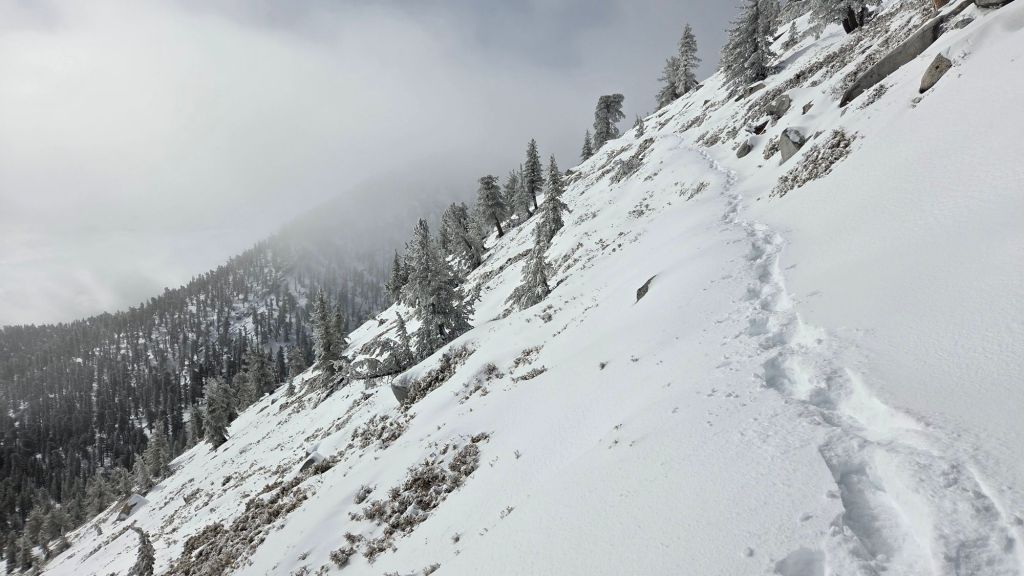
Snowshoeing conditions were exceptionally good on my ascent to San Jacinto Peak this morning, with very firm powder throughout. Temperatures are frigid however, below freezing everywhere above 4000 ft, with severe windchills in the high country.
Total snow accumulation at San Jacinto Peak is currently 21 inches, but with dramatic drifting everywhere above 9000 ft.
It started snowing both in Idyllwild and the high country at about 1115. Snow falling above 10,000 ft is extremely fine rounded grains, currently accumulating at just 0.25 inch/hour.
UPDATE Wednesday 18th February 2026 at 1200
The second storm of the sequence produced only seven inches of fresh snow at San Jacinto Peak overnight, for a total accumulation of 21 inches. Drifting has been severe, with strong winds at upper and mid elevations all night.
Fresh snow in Idyllwild (at 5550 ft) was an unexpectedly low three inches. Snow quality below 6000 ft is atrocious, with a very high water content, bordering on glorified slush. The overnight snow was preceded by 0.13 inch of rain late yesterday afternoon.
Snow dusted as low as 4400 ft in Garner Valley. Cloud became patchy by mid morning, with no further precipitation expected today.
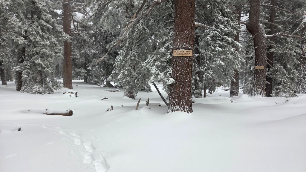
The USFS gate at Humber Park closed on 18th February. While theoretically nine legal parking spaces remain immediately below the gate, an unconventional ploughing approach this time has left space for only 2-3 vehicles to park safely. Parking on Forest Drive, just below the Fern Valley Water District facility, is strongly recommended.
UPDATE Tuesday 17th February 2026 at 1430
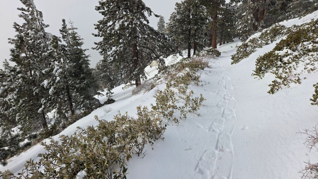
Snow depths measured on my hike this morning were: 9 inches at Devil’s Slide trailhead at Humber Park; 11 inches at Saddle Junction (8100 ft); 13 inches at Annie’s Junction (9020 ft); 9 inches at Wellman Divide (9700 ft); 14 inches at San Jacinto Peak.
The snow quality deteriorated as I descended, with delightful, fine, dry powder in the high country down to about 8500 ft, becoming markedly wetter and heavier below that elevation, especially on Devil’s Slide Trail.
Although the high country was largely above the cloud, it was snowing intermittently below 9000 ft on the west side of the mountains during my early afternoon descent, especially in Strawberry Valley (where Idyllwild is located), which traditionally gets socked in during storms that originate from the south-west.
Despite the air temperature only 1-2 degrees above freezing in Idyllwild this afternoon, melting has been rapid with nearly half of the overnight snow already melted.
UPDATE Tuesday 17th February 2026 at 0615
Total snow depth at San Jacinto Peak this morning is 14 inches, following a further eight inches overnight.
I recorded a short video report from the Peak at about 0830 (linked here). At this time, snow conditions are excellent for snowshoeing above 8000 ft, as low as 7000 ft in places.
Idyllwild (at 5550 ft) has had a storm total of six inches of snow. Snow dusted as low as 4500 ft elevation in places (but this has since melted rapidly).
The San Jacinto Trail Report celebrates ten years of operation this year. Since the Report became established online snow/ice rescues in the San Jacinto Mountains have declined 82%, the Report has been used by tens of thousands of hikers, and multiple lives have been saved, both directly and indirectly. While all time and labor is volunteered, the Report uses small donations to help cover modest operating costs. This keeps the Report available to all, free from paywalls or advertising, and independent from agencies. If you have found this Report useful, please consider using this Donate page link. Thank you very much for your support.
UPDATE Monday 16th February 2026 at 1950
Snow accumulated to 2.25 inches in Idyllwild (at 5550 ft) this evening before stopping at about 1900. It has also stopped in Long Valley (8500 ft) where about four inches fell this afternoon.
Very light snow of fine rounded grains continues at San Jacinto Peak, where the total depth is now about six inches (but heavily drifted). A final band of intense snow – to complete the first storm of three – is forecast for the early hours of tomorrow morning.
UPDATE Monday 16th February 2026 at 1630
Rain in Idyllwild this afternoon totaled 0.57 inch before turning to steady snowfall at about 1600.
In the high country snow has been steady all afternoon, but being very fine grains it is accumulating slowly, with three inches at San Jacinto Peak in the past five hours, and about two inches in Long Valley (8500 ft).
UPDATE Monday 16th February 2026 at 1430
As forecast, snow started falling right as I summited San Jacinto Peak at 1130. The fine grain snow, drifting in gusty winds, is accumulating at about 0.5 inch/hour. Winds have so far not been close to the gale force that was forecasted.
The initial wave of the first storm is relatively mild, and light rain started in Idyllwild at 1230, with 0.25 inch falling by 1430. The expectation is that it will start snowing at mid elevations overnight.
