The fifth storm system of winter 2025/26 is forecast to impact the San Jacinto mountains between Tuesday 23rd and Friday 26th December 2025.
Please check this page for periodic updates – the most recent is at the top – throughout the multiday storm sequence. The next comprehensive Report update, summarizing conditions after the storm, is tentatively scheduled for Saturday 27th.
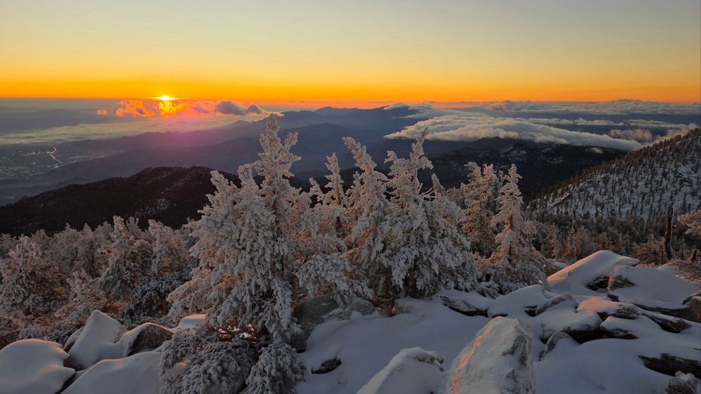
UPDATE Saturday 27th December at 0700
Overnight snowfall at San Jacinto Peak totaled 3.5 inches, for a rather paltry storm total of 7.5 inches.
I recorded a short video discussion from the Peak at 0730 this morning, giving a feel for the snow conditions underfoot (linked here).
Snow dusted down to 7800 ft, with one inch at 8500 ft (e.g., Long Valley).
Rainfall in Idyllwild at 0700 totaled 0.82 inch in the previous 24 hours.
Hikers this weekend will find spikes invaluable above 9000 ft, as there is extensive ice and icy snow on the main trails now obscured under a thin cover of fresh powder. Snow depths are insufficient for snowshoes, other than perhaps for off-trail travel only around the highest peaks, snd even then only for the next day or two as melting will be steady with warming temperatures.
UPDATE Friday 26th December at 2010
Fine granular snow has so far accumulated to two inches average depth in the past six hours at San Jacinto Peak, although the snow has been heaviest in the past hour.
A light dusting (<0.25 inch) in Long Valley at 8500 ft shortly before dusk melted, it then briefly rained at that elevation before recently turning to snow, with currently 0.5 inch accumulation.
Rainfall this afternoon in Idyllwild totaled 0.47 inch by 1900 (at 5550 ft), where it continues to rain gently.
UPDATE Friday 26th December at 1430
It started raining in Idyllwild at 1350 this afternoon, and about 15 minutes later started snowing lightly and intermittently at San Jacinto Peak. Forecasts have reduced expected precipitation amounts for this final phase of the storm system, with 3-4 inches of snow predicted for the high peaks, and under 0.5 inch rain for Idyllwild. Very light snow is expected as low as 6000 ft.
The Peak Trail is very icy starting immediately above Wellman Divide (9700 ft) and spikes are strongly recommended. The same is almost certainly true on upper Deer Springs Trail (there probably as low as 9000 ft).
UPDATE Thursday 25th December at 1200
There was no further precipitation overnight. I recorded a short video report from San Jacinto Peak this morning just after sunrise (linked here). With clearing skies, a sharp drop in temperatures, and such wet snow yesterday, the snow above 10,000 ft has frozen solid, making for very easy hiking (with spikes and/or appropriate boots).
The next low pressure system arrives tomorrow morning, Friday 26th, and a colder air mass should result in the snow level dropping to 6000 ft, possibly even lower. Snow estimates are about six inches above 10,000 ft and 2-4 inches at 8000 ft (e.g., Saddle and Strawberry junctions). Rainfall of 0.5-0.8 inch is forecast for the mid elevations.
While all time and labor is volunteered, the San Jacinto Trail Report uses small private donations to help cover operating costs. Your contribution keeps the Report available to all, free from advertising or paywalls, and independent from agencies. If you have found this Report useful, please consider using this link to the Donate page. Thank you very much for your support.
UPDATE Wednesday 24th December at 1915
It stopped snowing at San Jacinto Peak at about 1800, where unfortunately only 3.5 inches accumulated today.
The snow level today was astonishingly high, having dusted down to 9000 ft, but with no more than a barely measurable 0.25 inch at Wellman Divide. On his descent to the tram, Kyle Eubanks described Round and Long valleys as having “many rivers and waterfalls”, such was the volume of rainfall (plus snowmelt).
Idyllwild (at 5550 ft) recorded 0.76 inch of rain today, for a storm total of 1.17 inches, less than half the forecast expectations.
UPDATE Wednesday 24th December at 1630
Snowfall has been largely continuous at San Jacinto Peak for the past four hours, but often light, so far accumulating to 2.5 inches. Winds have been sustained at 25-30 mph, with gusts close to 40 mph, but it feels like the strongest winds and heaviest precipitation have slipped past to the west of the San Jacinto mountains.
Rainfall in Idyllwild since 0700 today has totaled 0.45 inch, for a storm total of 0.86 inch so far, roughly half of forecast.
That said, rain intensity is clearly localized, as Long Valley (8500 ft) is reporting 1.4 inches since midnight. I saw Kyle Eubanks at the Peak this afternoon and he commented that trails in Long and Round valleys were “like rivers”, so the relatively low rainfall for Idyllwild is evidently not representative of the whole mountain.
UPDATE Wednesday 24th December at 1200
Precipitation largely stopped at mid and upper elevations between 0700-1000, with light rain starting again above 10,000 ft at about 0950, finally turning to snow at 1150 around San Jacinto Peak. Winds are getting potent in the high country, sustained from SSW at 20 mph, gusting to 29 mph, but forecast to continue strengthening.
UPDATE Wednesday 24th December at 0620
At least in the San Jacinto mountains the initial front of the atmospheric river system is so mild (relatively speaking) that it is currently raining all the way to San Jacinto Peak.
Patchy, and at times intense, rain started in Idyllwild at 0200, with rain accumulation overnight 0.26 inch in Idyllwild (at 5550 ft), for a current storm total of 0.41 inch, with 0.22 reported in Long Valley (8500 ft).
UPDATE Tuesday 23rd December at 1700
One “arm” of the dramatic low pressure system forming off the California coast passed over the San Jacinto mountains around 1130 this morning, bringing light precipitation throughout. The temperature plunged more than 10°F in less than half-an-hour in the high country, and it briefly snowed above 8000 ft (with 0.5 inch briefly accumulating above 10,000 ft, and barely a dusting in Long Valley), and about 0.02 inch of drizzle in Idyllwild. The temperature rose again subsequently, largely melting the minimal fresh snow. It remained misty and drizzly throughout the early afternoon, totaling 0.15 inch in Idyllwild, before beautifully clearing out at dusk.
