The first significant storms of winter 2025/26 – three systems in eight days – are forecast to impact the San Jacinto mountains from Friday 14th to Friday 21st November 2025.
Please check this page for periodic updates – the most recent is at the top – throughout the multiday storm sequence. The next comprehensive Report update, summarizing conditions during and after the first two of the three storms, is tentatively scheduled for Wednesday 19th.
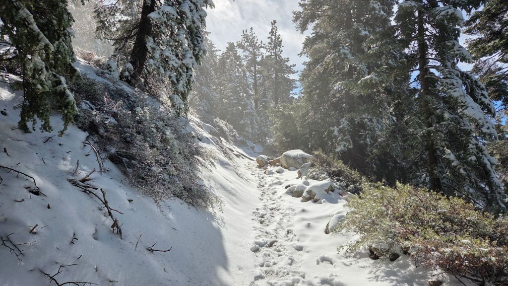
UPDATE Tuesday 18th November at 0800
The minor storm that moved through swiftly overnight produced a further three inches of snow at San Jacinto Peak – for a total on the ground of about 10 inches – and dusted locally as low as 6000 ft. The snow quality was perfect, a light powder, but that did drift heavily in gusty overnight winds, so tracks are obscured above 10,000 ft and snow in trails can be much deeper than expected.
At this time snow depths are marginal for snowshoes. That is expected to change, at least above about 9500 ft, following the next storm on Friday 21st.
Rainfall in Idyllwild totaled 0.51 inch, with no evidence of snow in Pine Cove (to 6300 ft).
I recorded a video report from San Jacinto Peak early this morning (linked here) which gives a good feel for current conditions.
UPDATE Monday 17th November at 1545
On my afternoon hike, snow conditions were poor and slushy to nearly 9000 ft, before improving above that elevation. Snow depths at Annie’s Junction (9020 ft) and Wellman Divide (9700 ft) are four and five inches, respectively.
At San Jacinto Peak (10,811ft/3295m) on Monday 17th November 2025 at 1515 the air temperature was 24.1°F (-4°C), with a windchill temperature of 5.5°F (-15°C), 72% relative humidity, and a fresh WSW wind sustained at 15 mph gusting to 23.9 mph.
UPDATE Monday 17th November at 1130
There was no further precipitation overnight. The second storm arrives tonight and is forecast to move through relatively quickly overnight, with several inches of additional snow in the high country and just under 0.5 inch of rain at mid elevations.
The current snow level is as low as 7000 ft in Strawberry Valley with a dusting down to 6600 ft. Snow depth increases steadily with three inches at 8000 ft (Saddle Junction) up to seven inches at San Jacinto Peak.
Devil’s Slide Trail for example has largely continuous snow in the trail above 7200 ft, which is currently slushy, but will freeze again overnight.
Carrying spikes is recommended everywhere above about 7000 ft at this time, along with the necessary clothing and equipment for genuine winter conditions. The storm coming in tonight is considerably colder, with high country air temperatures well below freezing and windchills far below freezing for the remainder of this week.
While all time and labor is volunteered, the San Jacinto Trail Report uses small private donations to help cover operating costs. Your contribution keeps the Report available to all, free from advertising or paywalls, and independent from agencies. If you have found this Report useful, please consider using this link to the Donate page. Thank you very much for your support.
UPDATE Sunday 16th November at 1900
Until it largely stopped at dusk, the rain was almost continuous in Idyllwild today, with an additional 0.84 inch in the past 12 hours for a storm total of 2.70 inches.
Periodic snowfall restarted in the high country by 1200, with the snow level remaining high (>7500 ft), but with only modest accumulation (struggling to reach 0.25 inch/hour) by the time it stopped in mid afternoon.
UPDATE Sunday 16th November at 0940
Periodic rain overnight at mid elevations produced another half inch in Idyllwild, for an impressive storm total at 5550 ft (since Friday 14th) of 1.86 inches by 0700 this morning (and it continues to rain steadily). Light snow overnight and into this morning has added about two inches at the elevation of Long Valley (8500 ft), with total depth at San Jacinto Peak now near six inches. The snow level has remained stubbornly around 7500 ft, with all elevations above that level having added an inch or two of snow since yesterday.
By 0930 it stopped snowing throughout most of the high country, with the cloud cover rapidly clearing on the eastern side of the mountain range. All forecasts are indicating relatively minimal further precipitation today as this first storm system moves away to the east, however rain-producing cloud often remains socked into the west slope valleys long after the high country has cleared.
UPDATE Saturday 15th November at 1830
Apologies for the delayed updating. As described below, it was a challenging day around the Peak. Snowfall at San Jacinto Peak was three inches by early afternoon, likely 4-5 inches by this evening, with two inches at Wellman Divide (9700 ft). There has been a dusting as low as 8000 ft (just below Saddle Junction), with a slushy 0.5 inch from there to 9000 ft elevation.
An additional 0.9 inch of rain in Idyllwild today brings the storm total at 5550 ft to 1.41 inches. Rainfall accumulation at Saddle Junction was 1.29 inches before turning to sleet/light snow.
We dealt with three cases of hypothermia in two separate hiker groups at San Jacinto Peak today, occupying most of the daylight hours. All cases were basically caused by hikers getting wet in the rain on their ascents and then running into the cold, wind, and snow at the highest elevations. Two women I assisted this afternoon exhibited serious symptoms, and I helped get them dry, provided them with extra clothing that I had, made hot beverages, and ultimately guided them part way back down the mountain. The good news is that I have had messages from both groups that everyone eventually got home safely. A tough day, but a great learning experience for those who ventured into the high country today.

UPDATE Saturday 15th November at 0930
The bad news from the top of the mountain is that it rained gently throughout the night at San Jacinto Peak, with the freeze level remaining stubbornly above 11,000 ft. Storm total rainfall by 0700 was 1.09 inches.
The good news is that it steadily turned to snow after 0700, accumulating to 0.75 inch by 0930. Currently the snow level is reported to be around Wellman Divide (9700 ft).
Rainfall storm total in Idyllwild up to 0700 this morning was 0.51 inch.
UPDATE Friday 14th November at 2020
The temperature at San Jacinto Peak has remained around 36°F all day, with consequently no snow but 0.79 inch of rain accumulating by 2015. It is forecast to turn to light snow overnight.
On our hike up this afternoon, there was intermittent light rain at all elevations above 6000 ft.
Total rainfall in Idyllwild in the past 24 hours has been an unexpectedly low 0.28 inch, most of which fell overnight.
UPDATE Friday 14th November at 1030
Rain accumulation overnight by 0700 was 0.20 inch in Idyllwild (at 5550 ft), with 0.05 inch in Long Valley (8500 ft). The start of the system was so mild – well above freezing even above 10,000 ft – that light rain fell at all elevations including around the highest peaks.
