Only the ninth storm of winter 2024/25 – but forecast to be one of the most notable for expected precipitation – is moving across the San Jacinto mountains between Wednesday 5th and Friday 7th March 2025.
Please check this page for periodic updates – the most recent is at the top – throughout the multiple day storm sequence. The next comprehensive Report update, summarizing conditions during and after the storm, may be published late on Friday 7th March.
UPDATE Friday 7th March at 0500
Final storm total at San Jacinto Peak is 18 inches, for a current total depth of about 27 inches (although variable due to extensive drifting, and up to three feet deep in places).
I recorded a short video (linked here) giving a feel for the gorgeous conditions at San Jacinto Peak early this morning.
Snow depth in Idyllwild (at 5550 ft) is an impressive 14 inches.
UPDATE Thursday 6th March at 2030
Snow depth at San Jacinto Peak is now around 22 inches, with 13 inches the current storm total. The lovely fluffy powder is ideal for snowshoeing. Several more inches are expected tonight.
Current accumulation is an impressive 8-9 inches in Idyllwild, and it continues to snow gently.
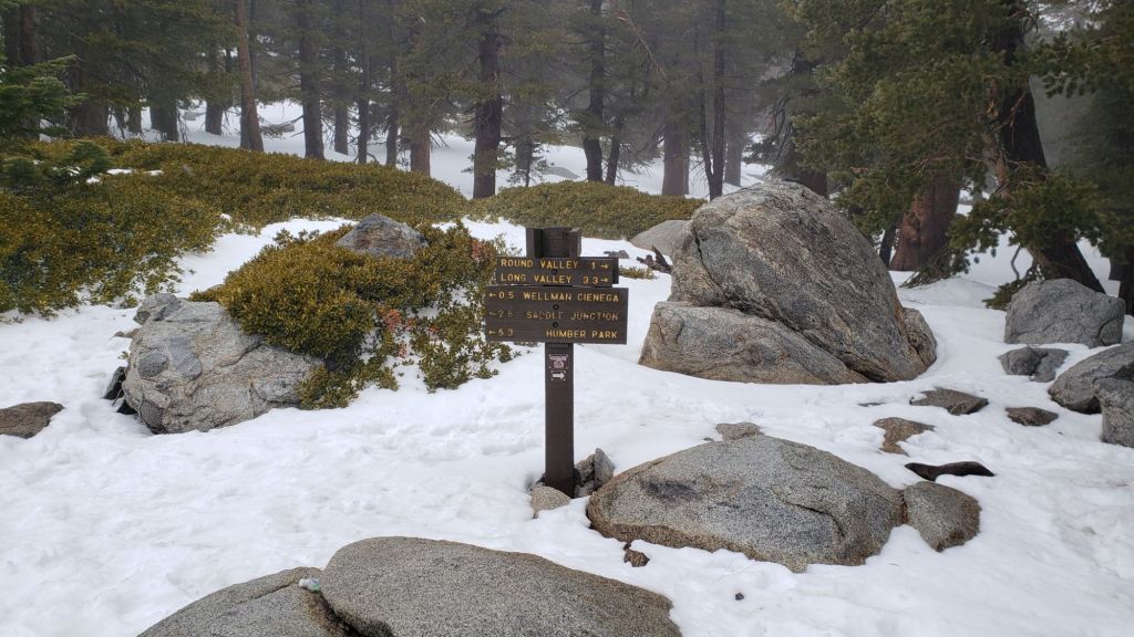
With significant snowfall now down below 5000 ft elevation, almost all the PCT in the San Jacinto mountains (Miles 151-196) are now covered with at least several inches of fresh snowfall. This will make for heavy postholing below 7000 ft, and snowshoes would be ideal above that elevation (potentially much lower) . Melting will be rapid at mid elevations this weekend, but further snow is expected next week.
UPDATE Thursday 6th March at 1730
After several hours of minimal snow at all elevations, snowfall has become markedly heavier in the past three hours, with larger flake size. Storm total is now 11 inches at San Jacinto Peak, accumulating at one inch per hour.
Snow depth in Idyllwild in Idyllwild is 5.5 inches at 5550 ft, following 0.78 inch of rain overnight.
UPDATE Thursday 6th March at 1100
Light snow in the mid elevations has accumulated to 1.25 inches in Idyllwild (5550 ft) and 2-3 inches in Pine Cove (6200 ft).
Snow at San Jacinto Peak is tiny rounded grains which consequently are struggling to accumulate to notable depth, another two inches this morning, for a current storm total of seven inches. Long Valley has about half that, roughly 3.5-4 inches.
The heaviest snowfall is forecast for this afternoon and evening, potentially doubling the current storm totals.
UPDATE Thursday 6th March at 0730
Fresh snowfall at San Jacinto Peak overnight was four inches, for a storm total of five, and a total depth of about 14 inches. Long Valley (8500 ft) added about three inches, for a total accumulation of about 8 inches.
Snow level is now below 5000 ft elevation, meaning that almost all the PCT in the San Jacinto mountains (at least Miles 151-195) will be covered with fresh snowfall.
Rainfall in Idyllwild at 5550 ft was 0.78 inch by 0700, having turned to snow around 0600 and already accumulating 0.75 inch. Rainfall generally at mid elevations (up to 6500 ft) was 0.8-1.0 inch throughout the western side of the mountain range, with much less at eastern locations.
While all time and labor is volunteered, the San Jacinto Trail Report uses small private donations to help cover operating costs. Your contribution keeps the Report available to all, free from advertising or paywalls, and independent from agencies. If you have found this Report useful, please consider using this link to the Donate page. Thank you very much for your support.
UPDATE Wednesday 5th March at 1920
Light drizzle started at about 1400 at mid and upper elevations. Yes, sadly it was warm enough (at just below freezing) to rain as high as San Jacinto Peak on my hike this afternoon.
By 1600 the precipitation finally turned to very light snow above 10,000 ft, although accumulation is less than 0.25 inch per hour.
After dark the snow level dropped to 8000 ft, with barely 0.25 inch of snow having accumulated in Long Valley (8500 ft) in two hours.