Only the seventh storm of winter 2024/25 – but by far the most notable one for expected precipitation – is forecast to move across the San Jacinto mountains between Wednesday 12th and Friday 14th February 2025.
Please check this page for periodic updates – the most recent is at the top – throughout the multiple day storm sequence. The next comprehensive Report update, summarizing conditions during and after the storm, may be published late on Friday 14th February.
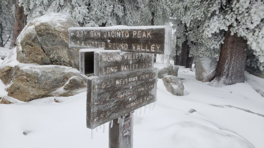
UPDATE Friday 14th February at 1010: it continues to snow gently in the high country, but it is accumulating at only 0.25-0.5 inch per hour. Storm total at San Jacinto Peak is 16-17 inches.
I recorded a short video report from San Jacinto Peak in the snow just after 0900 (linked here).
UPDATE Friday 14th February at 0700: Idyllwild has recorded an impressive 3.72 inches of rain in the past 24 hours, for a current storm total of 4.69 inches.
Snow depths broadly doubled overnight, with storm totals of 14-16 inches at San Jacinto Peak and 9-10 inches in Long Valley (8500 ft). Strong winds overnight mean that drifting is severe, with measurements around San Jacinto Peak ranging from 7-22 inches. Snow fell entirely as fine rounded grains (rather than big flakes) so couldn’t reach the most optimistic depths forecast.
UPDATE Thursday 13th February at 1700: Snow has been slow to accumulate at San Jacinto Peak, with currently 5.0 inches of fresh powder (but very heavily drifted in strong winds).
Snow level on my morning hike was above 9000 ft, with rain below 8500 ft, and sleet in between, but all are expected to drop overnight.
Idyllwild has added 1.32 inches of rain since 0700 today, for a storm total of 2.29 inches already (and the most intense precipitation still to come in the next few hours).
UPDATE Thursday 13th February at 1330: Freezing rain overnight reached all the way to San Jacinto Peak before turning to light snow early this morning. There is currently 3.5 inches of fresh powder at the Peak, and I measured 2.5 inches at Wellman Divide (9700 ft) a couple of hours earlier. The heavy snowfall is expected over the next 12 hours.
Idyllwild has added another 0.75 inches of rain since 0700 for a storm total of >1.7 inches so far. Trail conditions were challenging between 7500-9300 ft, with heavy water flows running underneath 1-2 inches of slush as the light snow from yesterday melted.
While all time and labor is volunteered, the San Jacinto Trail Report uses small private donations to help cover operating costs. Your contribution keeps the Report available to all, free from advertising or paywalls, and independent from agencies. If you have found this Report useful, please consider using this link to the Donate page. Thank you very much for your support.
UPDATE Thursday 13th February at 0700
Rainfall in the past 24 hours in Idyllwild has totaled 0.97 inch and is steadily intensifying. It finally started snowing lightly in Long Valley at about 0500 this morning, accumulating very slowly.
UPDATE Wednesday 12th February at 1950
Very light misty drizzle in Idyllwild for most of the afternoon and evening has added up to 0.15 inch so far. This aligns with most weather stations in the San Jacinto mountains which are reporting 0.1-0.2 inch, with 0.25 inch in Anza. The eastern slope is still not reporting any snow at upper elevations.
UPDATE Wednesday 12th February at 1340
We hiked to a windy and frigid Tahquitz Peak (8836 ft) this morning through very light, fine snow, and recorded a short video report from the fire lookout (linked here). Periodic brighter spells suggested that the top of the cloud was just above us, somewhere between 9000-10,000 ft, and hence unsurprisingly Long Valley (at 8500 ft on the east slope) remains snow-free at this time. No more than 0.5 inch accumulated around Tahquitz Peak, and by the time we descended, snow was starting to melt as high as 8500 ft and below 6500 ft it had already completely melted as the temperature rose to a few degrees above freezing.

UPDATE Wednesday 12th February at 0630
In the early hours of this morning Idyllwild was dusted with 0.25 inch of snow, but it had stopped by first light. The high country and eastern side of the mountains have remained largely above the cloud at this time, with no snow in Long Valley (8500 ft). As the bulk of the storm system moves in, temperatures are forecast to rise, with rain starting at mid elevations around noon and light snow in the high country around dusk. Total snow accumulation estimates for the high country have increased, with up to two feet now possible on Thursday.
