Southern California is experiencing the driest start to a winter since records began in 1850, as discussed in a recent National Weather Service San Diego video report (linked here). Riverside County, along with much of the rest of southern California, is currently under 5% of average precipitation for the water year (i.e. since 1st October).
There is only limited evidence for a significant change in the weather. The jet stream and associated atmospheric rivers are being forced generally to our north by a “Rex block” – an obstructive high/low pressure combination – which typically lasts for days, but has potential to persist for months. There is the possibility of a minor storm system bringing some precipitation on 25th-27th January.
December 2024 was the first time in recorded history that no snow fell in the San Jacinto high country in December, by far the latest into any winter on record with no settled snow in these mountains. Total snowfall at San Jacinto Peak since September 2024 has been a laughable 3.6 inches.
A minor storm on Tuesday 7th January briefly brought light snow throughout the mountains with a dusting down to 6500 ft and about an inch above 9000 ft. Three inches settled at San Jacinto Peak where I recorded a short video report that evening (linked here). Unfortunately the dusting below 9000 ft had largely melted already on sun-exposed slopes within 24 hours. Remaining snow is now largely melted and what little remains is thin and patchy. Most hikers will find spikes are not required anywhere on the trail system.
Survey hikes by the Trail Report every single day throughout the year in the San Jacinto mountains include varied routes to the high peaks including San Jacinto Peak typically 2-3 times per week (more frequently during storms), Tahquitz Peak and area 1-2 times per week, plus a wide variety of other trails on intervening days.
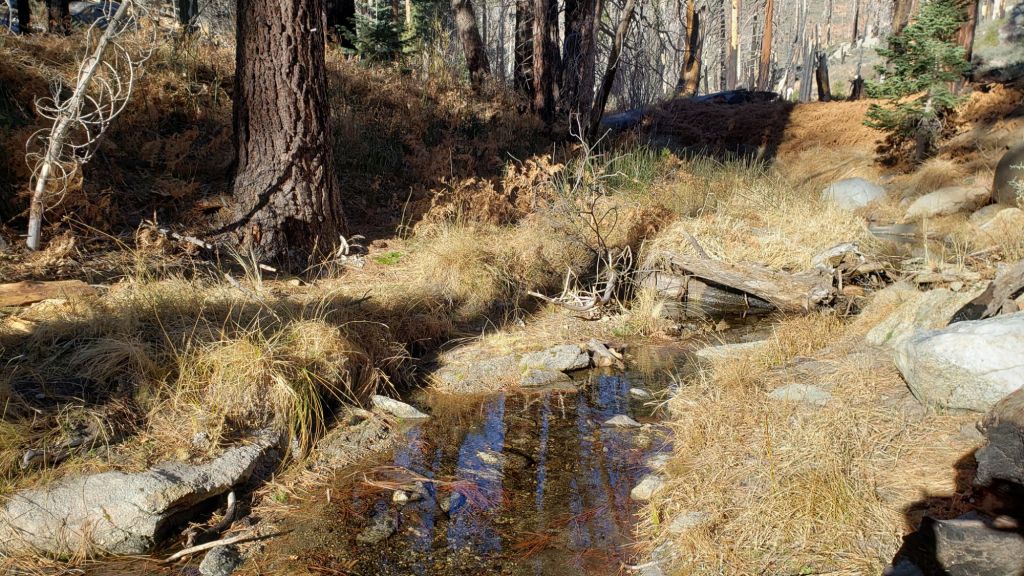
Despite a failed monsoon in 2024 and below-average precipitation both last winter and – very obviously – so far this season, most major springs, creeks, and pipes largely continue to flow at this time, surviving for now off the above average precipitation from September 2022 to August 2023 (see photos below and in the previous Report linked here). The Round Valley faucet continued to flow well as of 13th January 2025. The creek in Little Round Valley finally dried up in early January 2025. In the Tahquitz area meadows, the Tahquitz Valley pipe (for those who know where it is) continues to flow well. Tahquitz Creek is flowing at the northern end of Little Tahquitz Meadow, and adjacent to its source where it crosses the PCT at Mile 177. Strawberry Cienega is dry. Stone Creek is dry where it crosses Deer Springs Trail at about PCT Mile 183.6. Bud Spring near 9900 ft, just north-west of Marion Mountain, is flowing (photo in an earlier Report linked here). Cedar Spring is flowing gently. Tool Box Spring (at the top of Ramona Trail) continues to flow well as of mid January.

WEATHER
Temperatures have been largely above average for months dating back to last summer. Temperatures are currently forecast to be around or below seasonal until about Tuesday 21st, when they will quickly warm to well above average at all elevations on 22nd-24th, before falling again around Saturday 25th.
Temperatures in the high country will be near or below freezing for the next week, with cold windchills around the high peaks. A cold air storm system may pass over starting Saturday 25th and bring cold temperatures at the highest elevations on 25th-27th (air temperatures well below 20°F/-9°C, windchills potentially far below 0°F/-18°C).
Moderate to strong Santa Ana winds (i.e. largely from northeasterly directions) are forecast for 20th-23rd, especially severe on 20th-21st. Even though much of this winter has been unusually mild, air temperatures are nevertheless often near freezing above 10,000 ft, where strong winds (>20 mph) greatly influence the feel of temperatures and hence associated risks. At this time of year, hikers should always be prepared for winter temperatures in the high country regardless of forecasts and/or how relatively mild it may feel at trailheads (see my sample Peak weather observations below).
While prospects for precipitation into early February are slim, there is the possibility of a minor storm system bringing some precipitation on 25th-26th January. At this time it is too early to be confident about snow or rain probabilities or quantities associated with that possible storm system.
The latest National Weather Service San Diego video report (linked here) released on 17th January describes in detail the weather patterns expected over the next week and beyond.
At San Jacinto Peak (3295m/10,810ft) on Friday 17th January 2025 at 0800 the air temperature was 24.0°F (-4°C), with a windchill temperature of 8.6°F (-13°C), 22% relative humidity, and a fresh NW wind sustained at 8 mph gusting to 15.8 mph.
At the Peak on Monday 13th January 2025 at 0850 the air temperature was 17.8°F (-8°C), with a windchill temperature of 2.7°F (-16°C), 17% relative humidity, and a light due North wind sustained at 7 mph gusting to 11.6 mph.
At the Peak on Wednesday 8th January 2025 at 1115 the air temperature was 12.5°F (-11°C), with a windchill temperature of -14.3°F (-26°C), 86% relative humidity, and a frigid NNE wind sustained at 23 mph gusting to 33.9 mph.

TRAIL CONDITIONS
There is currently no continuous settled snow in the San Jacinto mountains, a truly unprecedented situation in recorded history this far into the winter months. The thin covering above 9000 ft that fell on 7th January only lasted for a few days despite cold temperatures (photos above and below). There is functionally no snow on trails below 9900 ft on the eastern side trails, with thin but locally icy patches at 9900-10,100 ft on the Peak Trail and around San Jacinto Peak. The East Ridge Trail (Miller-San Jacinto peaks) is still largely snow-covered. Snow is gone on Deer Springs Trail below 9500 ft, and is sparse and patchy above that. Few if any hikers will find that traction devices are required anywhere on the trail system.
Treefall hazards remain a significant problem along parts of the Pacific Crest Trail, most notably between Antsell Rock and South Peak. Some 56 trees are down across the trail between PCT Miles 170.5-174, with 37 of these, including several serious obstructions that make for slow-going, between Miles 172.5-174 (around and immediately south of South Peak). A further nine smaller obstructions are down from Miles 168.5-170.5 (Spitler Peak Trail to Zen Center Trail). Significant sections of Miles 168.5-175 are also badly overgrown with brush and are in urgent need of major trimming work (surveyed late 2024).
On the Fuller Ridge Trail section of the PCT there are 12 trees down on the State Park section of the trail (Miles 185.5-189, which have not been maintained by that agency for many years). Several of these pose quite significant hazards for hikers. On the Forest Service section (Miles 189.3-190.5) five significant treefall hazards were removed by USFS late in 2024.
On the section of Deer Springs Trail between Strawberry Junction and the top of Marion Mountain Trail (roughly PCT Miles 183-185) five new major treefall hazards came down in strong winds in early January 2025, bringing to seven the number of major downed trees on this section. These have been reported to the State Park. A further 8-9 trees are on the upper trail (above Fuller Ridge) have been down and reported repeatedly for a decade but with no action from the State Park.
Trees down on the Strawberry Trail section of the PCT (Annie’s Junction to Strawberry Junction, Miles 180.8-183) have remained uncut by the Forest Service for nearly a decade. About six hazards on this section are thankfully all relatively easy for hikers to negotiate.
The Trail Report heavily trimmed the formerly overgrown Wellman Trail (Annie’s Junction to Wellman Divide) in September-December 2024 and this work continues in January 2025. We continue to trim South Ridge Trail year-round, but with increased effort in December-January 2024/25.
The Trail Report removed almost all the obstructive whitethorn from Spitler Peak Trail in December 2024, largely in the central portion of the trail (miles 2.0-3.2 from the trailhead). Another 37 treefall hazards were cleared by the Trail Report in 2024, bringing to 123+ the total number of downed trees removed by the Report from this trail in recent years. While more brush trimming work is always required, in general the trail is currently in its best condition since at least mid 2023. Spitler Creek continues to flow gently at its various crossings in the upper switchbacks, and Antsell Rock Creek starting flowing gently again in November but will likely dry again soon.
The Caramba Trail from near Reeds Meadow through Laws Camp and on to Caramba, and the Cedar Trail from Willow Creek Trail to Laws, are euphemistically (and potentially dangerously) described by the Forest Service as “not maintained”. In reality both trails have been abandoned and no longer exist. They are so heavily overgrown, largely with dense whitethorn, which obscures dozens of downed trees, that hikers should not attempt to follow them (regardless of how much you may trust an app). An informal use trail to Laws is much more direct, well maintained, and avoids the bushwhacking of the unmaintained trails (some local Idyllwild hikers dubbed it the “King Trail” when I established the route in 2019). It leaves Willow Creek Trail exactly 1.0 mile from Saddle Junction, 0.46 mile from the Skunk Cabbage turning (trailhead at N 33.7796, W 116.6590). The route descends largely following established deer trails for 1.2 miles, meeting Willow Creek about 0.2 mile upstream from the site of the historic Laws Camp (the remains of which were destroyed by the 2013 Mountain Fire and subsequent flood and treefall damage). One huge tree fell in late 2024 across the King Trail about midway down and requires a minor scramble underneath (that tree will not be cut soon). Another five recently downed trees were either removed or worked around in early January 2025, when the trail was thoroughly trimmed and raked. From Laws east to Caramba the route of the original Caramba Trail has been cairned by myself and others and can largely be followed with very careful route-finding. My first 2025 survey counted about 120 trees down on this 2.1 miles of trail. It is especially obscure for the first 0.3 mile east of the Willow Creek crossing, becoming more obvious (but still subtle) as it descends towards Caramba. Very cautious navigation is advised throughout the area.
Willow Creek Trail is nearing its 2020 condition, the last time the original trail route was fully cleared and passable. Almost all significant treefall hazards on the Forest Service section were cut by mid August (several uncut trees remain that need to be removed to fully restore the original trail route). Whitethorn trimming was largely completed, mainly by volunteers, on the Forest Service side in August and early September 2024. On the State Park side some localized whitethorn trimming of the worst patches was undertaken in September, and the minor treefall hazards new in 2023/24 were removed, leaving just two major long term downed trees (both have simple workarounds for hikers).
The Trail Report “adopted” Seven Pines Trail as a priority for maintenance work as the trail had a disproportionate number of lost hiker rescues in the past decade, and both State Park and Forest Service have shown no interest in maintaining the route for years. Since 2020 we have removed 75 downed trees and the trail is trimmed and cleared multiple times annually. As of late 2024 the trail is largely clear of treefall hazards, with three down across the trail in its upper section, all easily passable for hikers. A further half-a-dozen downed trees close to the PCT junction would need to be removed to fully restore the original route of the trail. Although the condition of the trail is hugely improved, Seven Pines remains a genuine wilderness trail unlike the wider, bare, obvious routes of, for example, Devil’s Slide or Marion Mountain trails. Cautious navigation remains essential for those without considerable experience of hiking this trail. Be aware in particular that Seven Pines Trail becomes most obscure in the mile closest to its junction with Deer Springs Trail/PCT.
The Zen Center Trail continues its serious deterioration that started following the 2013 Mountain Fire, with a combination of vigorous regrowth and treefall hazards further obscuring the route with each passing season. The lower and upper thirds of this trail are partially cairned and not too bad for those who are very familiar with the former route, but even the experienced find navigating the central section tricky. Long trousers, scrambling gloves, and an enjoyment of bush-whacking are all strongly recommended.


While all time and labor is volunteered, the San Jacinto Trail Report uses small private donations to help cover operating costs. Your contribution keeps the Report available to all, free from advertising or paywalls, and independent from agencies. If you have found this Report useful, please consider using this link to the Donate page. Thank you very much for your support.