Thankfully a record hot July finished with a few cooler days, although further hot temperatures well above seasonal averages returned on 3rd August and are forecast to continue until about 13th.
Both 1st and 2nd August were pleasantly cloudy and cool, albeit humid, days, with just a hint of drizzle on 1st (photo below) and our first proper (if brief) monsoonal rainstorm on Friday 2nd. San Jacinto Peak recorded 0.02 inch of rain on 1st August and 0.31 inch on 2nd. Rainfall was heaviest on both sides of the mountain at 9000-10,000 ft on 2nd, with 0.51 inch in Little Round Valley (9750 ft) and 0.62 inch at Wellman’s Cienega (9300 ft), with less lower down including 0.30 inch at Saddle Junction (8100 ft) and 0.34 inch near the top of Marion Mountain Trail (8650 ft). Further down the mountain Idyllwild at 5550 ft recorded 0.11 inch.
Provisional data suggest that July 2024 was the hottest month in recorded Idyllwild history, with all 31 days exceeding the monthly average for overnight low temperatures. The average daytime high temperature of 91.1°F for the entire month greatly exceeds the July average of 85.3°F, but even more striking was the average low of 64.7°F, which remarkably surpassed the July historical average of 55.2°F by nearly ten degrees. Both those high and low averages for July 2024 are likely to be all-time records.
In addition to a plethora of new daily and monthly heat records, Idyllwild surpassed 90°F (32°C) for a record twelve consecutive days from 2nd-13th July. The high country fared no better, as San Jacinto Peak shattered its record for consecutive days of at least 60°F (16°C) with all ten days from 3rd-12th July surpassing that temperature (the prior record was just four days). The 68.7°F (20°C) I measured at San Jacinto Peak on the morning of Monday 22nd July was a new all-time record high temperature there, breaking a record set only two weeks earlier (which itself broke a record from July 2021).
Hikers must be prepared for unseasonably hot weather in the high country on most days from 3rd-13th August, with temperatures above seasonal at all times of day (especially overnight) and at all mountain elevations. Please give considerable extra thought to start times, route choice (considering sun exposure, forest cover, and water availability), appropriate clothing, sun protection, and hydration requirements, or indeed whether it is wise to be hiking at all in such conditions. There was one heat-related hiker fatality plus multiple cases of heat exhaustion in the San Jacinto high country in July 2024.
Survey hikes by the Trail Report every day year-round in the San Jacinto mountains include varied and often circuitous routes to San Jacinto Peak multiple times per week (almost daily since 1st July), plus other trails on intervening days.
Monsoon conditions are forecast as possible for the remainder of the first half of August, currently most likely on 9th-11th. Hikers should be prepared for the possibility of rapidly changing weather conditions in the high country. Thunderstorms with lightning, intense precipitation, and rapid temperature drops can occur, usually in the afternoon, even when such storms may not be forecast for lower elevations.
With such hot and dry conditions, fire risk is severe everywhere. A comprehensive fire ban is in place on Forest Service lands throughout the San Jacinto Ranger District (link to USFS order here) and in all Idyllwild campgrounds. Campfires are of course always prohibited throughout both the State Park and National Forest wilderness areas. The Nixon Fire – held at about 5200 acres – was clearly visible due south of San Jacinto Peak on Tuesday 30th July, with a solid line of smoke blowing eastward over the Santa Rosa mountains and down into the Coachella Valley, but looked far more benign on subsequent days.
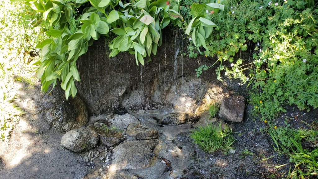
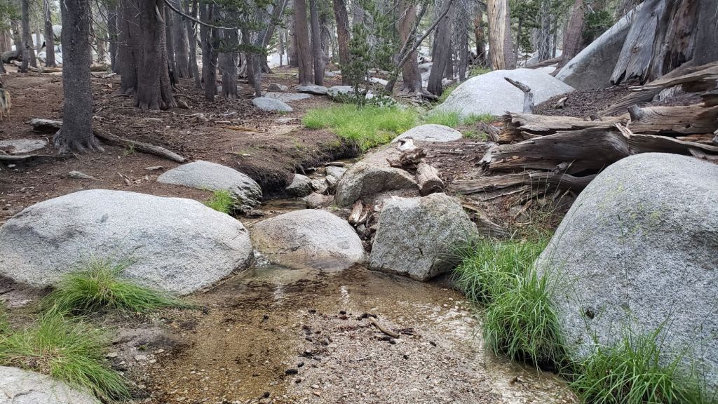
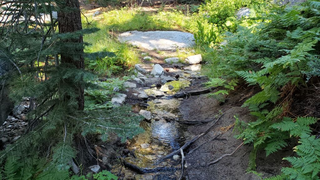
All major springs, creeks, and pipes continue to flow adequately at this time (example photos below). However flow rates are dropping steadily at upper elevations and almost all ephemeral water sources are now dry. The Round Valley faucet continued to flow very well as of 5th August.
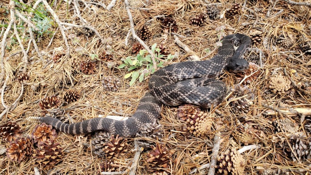
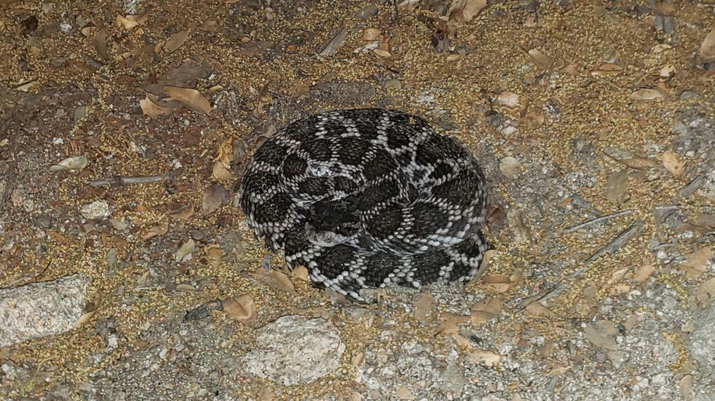
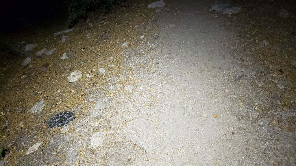
Be rattlesnake aware. Southern Pacific Rattlesnakes (Crotalus [oreganus] helleri) have been abundant on the trail system this summer. Above about 5000 ft, the venom of this rattlesnake species in these mountains is predominantly neurotoxic, almost always fatal for dogs and sometimes for humans (see my detailed 2020 article linked here for further information). Devil’s Slide Trail, lower Deer Springs and lower Marion Mountain trails, Suicide Rock, near Strawberry Cienega, and trails around Tahquitz Peak are all common locations for sightings, but rattlesnakes have been recorded everywhere to 9350 ft. (See additional photos of another individual at foot of this posting.)

Be bear aware. Although rarely reported in recent years, up to three Black Bears have been in the San Jacinto mountains since 2017. I have seen at least one annually for the past six years, most recently on upper Marion Mountain Trail on 14th September 2023. I also found fresh prints in snow on 12th February this year at 9000 ft near PCT Mile 180.5 (photo here). Brief videos from Devil’s Slide Trail in September 2021 (available here) and at home in Idyllwild in 2018 (linked here) show two different individuals. There have been no reports of negative interactions with humans at or near campsites.
The Palm Springs Aerial Tramway will be closed starting Monday 9th September 2024 for annual maintenance, with a tentative reopening date of Monday 7th October.

WEATHER
After a lengthy and record-breaking heatwave in the first half of July temperatures dropped somewhat between 14th-17th, before a second heat dome rose temperatures again to well above seasonal for another ten days. Some pleasant cooling arrived for 27th July-2nd August (although temperatures nevertheless largely remained at or slightly above seasonal!).
A third heat dome of the summer moved over the desert south-west around 3rd August, and temperatures will be well above average for 3rd-13th August at least (i.e. generally near or above 90°F in Idyllwild and close to 60°F at San Jacinto Peak). As is increasingly the case with a steadily heating climate in the San Jacinto mountains, overnight low temperatures in particular were well above seasonal throughout July and this will continue throughout the first half of August.
There is currently no significant precipitation in the forecasts, but monsoonal thunderstorms are always a possibility in late summer, generally in afternoons, and currently most likely on August 9th-11th.
At San Jacinto Peak (3295m/10,810ft) on Tuesday 6th August 2024 at 0710 the air temperature was 56.7°F (14°C), with a “windchill” temperature of 54.7°F (13°C), 45% relative humidity, and a gentle WNW wind sustained at 3 mph gusting to 5.5 mph.
At the Peak on Monday 5th August 2024 at 0805 the air temperature was 59.0°F (15°C), with a “windchill” temperature of 54.5°F (12.5°C), 57% relative humidity, and a variable WSW wind sustained at 4 mph gusting to 10.4 mph.
At the Peak on Saturday 3rd August 2024 at 0735 the air temperature was 53.5°F (12°C), with a windchill temperature of 48.3°F (9°C), 52% relative humidity, and a fresh SSE wind sustained at 7 mph gusting to 11.4 mph.

TRAIL CONDITIONS
Snow was completely gone from the high country trails by mid June.
The State Park announced closure of the uppermost section of Skyline Trail – which forms the lower part of the C2C (Cactus-to-clouds route) – in their jurisdiction, i.e. above about 5600 ft, on 12th July due to “dangerously high temperatures impacting the Palm Springs region”. The trail “will continue to be closed until further notice”.
Treefall hazards remain a major problem along parts of the Pacific Crest Trail, most notably between Antsell Rock and Red Tahquitz, with 132 recorded in my recent 2024 surveys between Miles 170.5-175.5. The disinterest of Forest Service and PCTA in maintaining this section of a world-famous trail for the past five years is unconscionable. Concentrations of large downed trees make for especially slow-going around Miles 170.5-172 (east side of Antsell Rock) and Miles 174-175 (south and east sides of Red Tahquitz). A further 15 smaller trees are down from Miles 168.5-170.5 (Spitler Peak Trail to Zen Center Trail).
About 12 treefall hazards on Deer Springs Trail include 8-9 in the upper trail that have been down and reported repeatedly for years but with no action from the State Park. All but one of the treefall hazards down between Strawberry Junction and the top of Marion Mountain Trail (roughly PCT Miles 183-185) were removed by the Trail Report in late June (example photos in an earlier Report linked here).
On Willow Creek Trail the smaller treefall hazards on the Forest Service section were cut in June. One of the two huge hazards remaining on the Forest Service side was removed in early July, but the larger, more difficult obstruction, remains. An additional four need to be cut to restore the original trail route. Whitethorn along the trail is starting to grow back rapidly, and is becoming a problem on both the Forest Service and State Park sections (photo in previous Report linked here). Treefall hazards currently on the State Park side include two large ones remaining from last year, plus three small new ones, but none pose major problems for hikers.
The 34 treefall hazards that came down across Spitler Peak Trail during ice storms in February 2024 were almost all cleared by the Trail Report on 14th June. The couple of minor stepover branches that remain pose no problem for hikers. This work brings to 120+ the total number of trees removed by the Report from this trail in the past three years. Note that currently the upper trail in particular is heavily overgrown with lush seasonal vegetation.
The Caramba Trail from near Reeds Meadow through Laws Camp and on to Caramba, and the Cedar Trail from Willow Creek Trail to Laws, are euphemistically described by the Forest Service as “not maintained”. In reality both trails have been abandoned and functionally no longer exist. They are so heavily overgrown with dense whitethorn, which obscures dozens of downed trees, that I strongly advise hikers do not attempt to follow them (regardless of how much you may trust an app). An informal use trail to Laws is much more direct, maintained, and avoids the challenging bushwhacking of the unmaintained trails (local Idyllwild hikers dubbed it the “King Trail” when I established the route in 2019). It leaves Willow Creek Trail exactly 1.0 mile from Saddle Junction, 0.46 mile from the Skunk Cabbage turning (trailhead at N 33.7796, W 116.6590). The route descends largely following established deer trails for 1.2 miles, meeting Willow Creek about 0.2 mile upstream from the site of the historic Laws Camp (the remains of which were destroyed by the 2013 Mountain Fire and subsequent flood and treefall damage). Eleven trees down on the King Trail were removed in June-July 2023. The tread of the trail received some damage from Tropical Storm Hilary last year. From Laws east to Caramba the route of the original Caramba Trail has been well-cairned by myself and others and can largely be followed with very careful route-finding. My 2023 survey counted about 110 trees down on this 2.1 miles of trail. It is especially obscure for the first 0.3 mile east of the Willow Creek crossing, becoming more obvious (but still subtle) as it descends towards Caramba. Very cautious navigation is advised throughout the area.
The Trail Report “adopted” Seven Pines Trail as a priority for maintenance work as the trail had a disproportionate number of lost hiker rescues in the past decade, and both State Park and Forest Service have shown no interest in maintaining the route for years. Since 2020 we have removed 75 downed trees and the trail is thoroughly trimmed and cleared multiple times annually. As of July 2024 the trail is largely clear of treefall hazards, with three down across the trail in its upper section, all easily passable for hikers. A further half-a-dozen downed trees close to the PCT junction would need to be removed to fully restore the original route of the trail. Although the condition of the trail is hugely improved, Seven Pines remains a genuine wilderness trail unlike the wider, bare, obvious routes of, for example, Devil’s Slide or Marion Mountain trails. Cautious navigation remains essential for those without considerable experience of hiking this trail. Be aware in particular that Seven Pines Trail becomes most obscure in the mile closest to its junction with Deer Springs Trail/PCT.
The Zen Center Trail continues its deterioration that started following the 2013 Mountain Fire, with a combination of vigorous regrowth and treefall hazards further obscuring the route with each passing season. The lower and upper parts of this trail are partially cairned and not too bad for those who are very familiar with the former route, but even the experienced find navigating the central section tricky. Long trousers, scrambling gloves, and an enjoyment of bush-whacking are all strongly recommended.
While all time and labor is volunteered, the San Jacinto Trail Report uses small private donations to help cover operating costs. Your contribution keeps the Report available to all, free from advertising or paywalls, and independent from agencies. If you have found this Report useful, please consider using this link to the Donate page. Thank you very much for your support.


I re-read the article you wrote about Anabel’s recovery from her SPR bite. It still brings me to tears. And makes me redouble my surveillance to avoid rattlesnakes!
I have never met you in person, but I saw you a few weeks ago, one early morning I was at the hut below the peak when I saw this beautiful animal, now I know to be Anabel, accompanied by a fast moving man headed for the peak, whose voice I instantly recognized from watching your videos. So, hello.
Thank you for the Report.
Jane, an old hiker and occasional donor
>
LikeLike
Thank you so much Jane for the kind words and years of generous support. Sorry I missed you at the Peak, we would have stopped to say hello had we known. Yes, I reread the article too the other day, given how many rattlesnakes I have been seeing. An accompanying box of tissues is required!
Safe hiking, and we look forward to seeing you on the trails (again) one day soon, Jon.
LikeLike