Most hikers will find it is now straightforward to bareboot all of the established trails, including the entire PCT through the San Jacinto mountains. Hikers with limited experience on patchy icy snow may find that carrying spikes remains a good option locally above about 9000 ft. Spikes tend to be particularly useful for descending, especially later in the day as the snow structure deteriorates, even when they generally not required for ascending. Spikes remain recommended for off-trail travel above 10,000 ft.
Daily survey hikes in the San Jacinto mountains include various routes to San Jacinto Peak multiple times per week (most recently on 20th, 24th, 28th May, and 1st June), Tahquitz Peak and area at least once per week (most recently on 25th and 29th May), plus a wide variety of other routes on intervening days.
I am no longer providing snow depth data, as very little snow remains below 10,000 ft. This does not mean there is no snow in the high country, only that it is too patchy to give meaningful measurements (see photos below). Some high elevation areas still hold 1-2 feet of increasingly patchy snow (e.g,, Little Round Valley, east flank of San Jacinto Peak, north side of Jean Peak)
All major springs, creeks, and pipes (and many ephemeral ones too) are flowing well at this time (example photo below). Flow rates are dropping rapidly however – Middle Spring on Devil’s Slide Trail is already down to just 25% of its early May flow – and a long, hot summer is provisionally forecast (e.g., see NWS San Diego discussion linked here).
Campgrounds reopened in time for the Memorial Day weekend. Black Mountain Road reopened for the season on Wednesday 22nd May. The boulder in the road about 0.5 mile above that gate was removed last week, and Pinewood residents graded the lower 1.7 miles of the road on 18th May. The entire road is clear of snow.
Dark Canyon Road had been closed almost continuously since February 2019, but reopened on 24th May for the summer. Black Mountain fire lookout reopened on 19th May, and Tahquitz Peak fire lookout on 26th May. South Ridge Road reopened for the season on 23rd April. Due to a localized section of mud, the uppermost road is currently best suited to high clearance AWD/4WD vehicles.
Be rattlesnake aware. Southern Pacific Rattlesnakes (Crotalus helleri) have been seen on the trail system up to at least 8100 ft elevation already. The volume of reports and sightings suggest abundant snake populations this year in the San Jacinto mountains. Rattlesnakes will get increasingly active with warmer weather and may be seen anywhere up to about 9300 ft by the end of May.

WEATHER
Seasonal temperatures in recent days will soon be replaced by hot weather and temperatures more typical of July-August than for late May/early June, starting on Thursday 30th May. Temperatures will be above even midsummer averages on 5th-6th June at least. As is increasingly the case in a heating climate in the San Jacinto mountains, overnight low temperatures in particular will be far above seasonal well into the first week of June. What little snow remains will of course melt rapidly. There is currently no significant precipitation in the forecasts.
At San Jacinto Peak (3295m/10,810ft) on Tuesday 28th May 2024 at 0740 the air temperature was 47.2°F (8°C), with a windchill temperature of 41.0°F (5°C), 13% relative humidity, and a light due South wind sustained at 4 mph gusting to 10.3 mph.
At the Peak on Friday 24th May 2024 at 0800 the air temperature was 35.4°F (2°C), with a windchill temperature of 21.6°F (-6°C), 37% relative humidity, and a fresh due West wind sustained at 16 mph gusting to 22.6 mph.

TRAIL CONDITIONS
Except where discussed below, trails are clear of snow. All trails below 8000 ft are now clear of snow. Notable snow remains below 9000 ft only in a few sheltered areas. Sun-exposed trails as high as San Jacinto Peak are now largely clear of snow, especially on the Peak’s south flank. Tracks through the remaining snow patches remain hard and icy in places early in the morning, but soften quickly by mid morning, getting sloppy as early as midday.
South Ridge Trail is clear of snow to Tahquitz Peak on its south approach. The Trail Report cleared this winter’s accumulated treefall hazards from South Ridge Trail in April and has also undertaken extensive trail trimming in recent months. The 0.4 mile section of South Ridge Trail between Chinquapin Flat/PCT Mile 177 and Tahquitz Peak is now functionally clear of snow. A couple of remaining tiny snow patches are easy to hike around.
Devil’s Slide Trail is clear of snow. The Trail Report has undertaken extensive trail maintenance work since February to remove many tree limbs in and over the trail damaged by ice storms this winter.
The Peak Trail is now functionally clear of snow to its junction with Deer Springs Trail at 10,500 ft, but a few areas of limited snow patches remain. As usual the most persistent sections of snow patches remain around 9900-10,100 ft, and then above 10,400 ft. The area immediately around San Jacinto Peak is still largely snow-covered on the east approach, but snow-free on the south side. The East Ridge trail route remains 80% snow-covered, and the track is increasingly riddled with suncups (photo above).
Wellman Trail is now clear of snow where it is outside of forest cover, with only patchy 20% snow cover on the forested first 0.25 mile north of Annie’s Junction (the Forest/State Park boundary).
The Round Valley Trail averages only 10% snow cover in its uppermost section, within 0.3 mile of Wellman Divide. The remainder of the trail is clear of snow.
Deer Springs Trail is now functionally clear of snow to its junction with the Peak Trail at 10,500 ft. Snow cover averages only 5% on the trail above 8700 ft (the Marion Mountain Trail junction). In Little Round Valley snow cover averages 30% but is declining daily, and the drifts pose no navigation or traction issues. From the upper end of Little Round Valley to San Jacinto Peak snow cover is now only 10% with most of the trail exposed. Spikes are generally no longer required but some hikers may find them helpful, along with cautious navigation.
Willow Creek Trail is clear of snow. Overall the trail is in reasonable condition, and certainly far more hiker-friendly than this time last year. Whitethorn along the trail has not (yet) grown back significantly, other than a couple of minor areas near Hidden Divide in the State Park section. Sixteen treefall hazards on the trail include 11 on the Forest Service section (two remaining from last year, plus nine new this winter) and five on the State Park side (two large ones from last year, plus three small new ones). Almost all of the downed trees on the USFS section are north of Willow Creek. Unfortunately two of the hazards on the Forest Service section are huge (four-plus feet diameter) and some hikers will find them challenging to cross.

Spitler Peak Trail suffered badly during ice storms in early February, and I found 34 new treefall hazards down during my surveys in late winter, almost all in the upper half. Most are relatively small and readily passable, but a few are larger, and the combined effect is to make for a slower and scrappier hike.
The Caramba Trail from near Reeds Meadow through Laws Camp and on to Caramba, and the Cedar Trail from Willow Creek Trail to Laws, are euphemistically described by the Forest Service as “not maintained”. In reality both trails have been abandoned and functionally no longer exist. They are so heavily overgrown with dense whitethorn, which obscures dozens of downed trees, that I strongly advise hikers do not attempt to follow them (regardless of how much you may trust an app). An informal use trail to Laws is much more direct, well maintained, and avoids the challenging bushwhacking of the unmaintained trails (local Idyllwild hikers dubbed it the “King Trail” when I established the route in 2019). It leaves Willow Creek Trail exactly 1.0 mile from Saddle Junction, 0.46 mile from the Skunk Cabbage turning (trailhead at lat/long N 33.7796, W 116.6590). The route descends largely following established deer trails for 1.2 miles, meeting Willow Creek about 0.2 mile upstream from the site of the historic Laws Camp (the remains of which were destroyed by the 2013 Mountain Fire and subsequent flood and treefall damage). The 11 trees down on the King Trail were removed in June-July 2023. The tread of the trail received some minor damage from Tropical Storm Hilary last year. From Laws east to Caramba the route of the original Caramba Trail has been well-cairned by myself and others and can largely be followed with very careful route-finding. My August 2023 survey counted about 110 trees down on this 2.1 miles of trail. It is especially obscure for the first 0.3 mile east of the Willow Creek crossing, becoming more obvious (but still subtle) as it descends towards Caramba. Very cautious navigation is advised throughout the area.
Seven Pines Trail is largely (by its formerly low standards) clear of treefall hazards, with about ten down across the trail, most in the central mile, but they are easily passable for hikers. A few extended snow patches remain near the junction with Deer Springs Trail. Be advised that the trail in general becomes more obscure in the mile closest to its junction with the PCT. The Trail Report has “adopted” Seven Pines Trail as a priority for maintenance work as the trail has had a disproportionate number of lost hiker rescues in the past decade. Since November 2021, about 70 downed trees have been removed and the trail is thoroughly trimmed and cleared regularly (but not yet in 2024). Nevertheless Seven Pines remains a genuine wilderness trail unlike the relatively wide, bare, and obvious routes of, for example, Devil’s Slide or Marion Mountain trails. Cautious navigation remains essential for those without considerable experience of hiking this trail.
On the PCT treefall hazards remain a problem in many places, most notably between Apache Peak and Red Tahquitz, with at least 110 down in my most recent survey. Large downed trees make for especially slow-going around Miles 172-175 (a section severely burned in the July 2013 Mountain Fire).
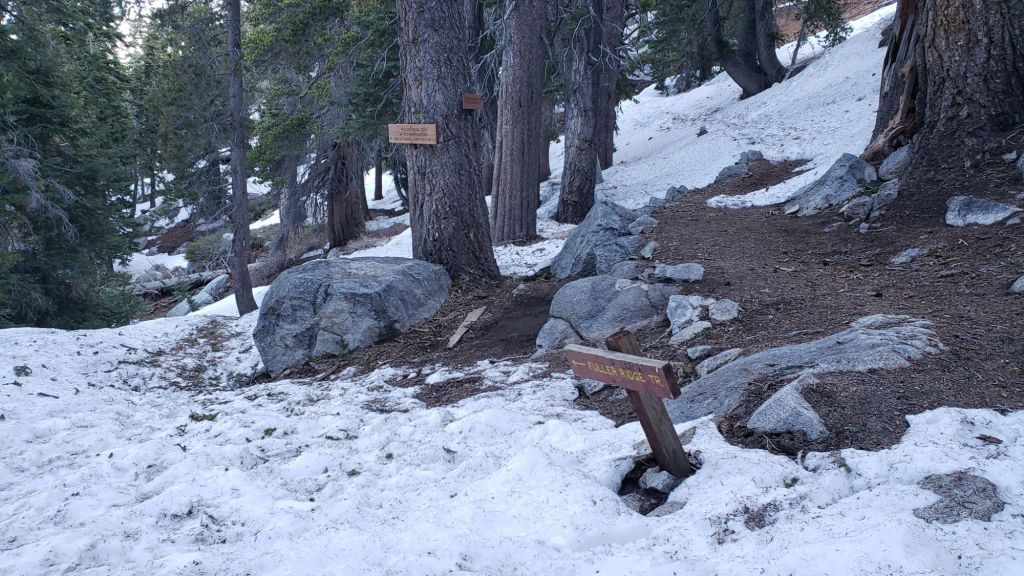
The Pacific Crest Trail is now largely clear of snow through the San Jacinto mountains, but hikers less experienced with patchy icy snow may continue to find spikes useful for a few more days. The trail is clear from Miles 151 (Highway 74) to about 174.5. The track on the north side of Red Tahquitz (Miles 175-177) has some persistent snow patches averaging 20% snow cover. The trail is functionally clear of snow to Mile 184.5, with a few snow patches through the sheltered forest at Miles 180-181. The frequency of snow patches is higher, but no longer problematic, between Miles 184.5-190. A few short sections average about 30% snow cover. Large sections of Fuller Ridge Trail are now clear. Traversing this section is now straightforward barebooting but carrying spikes will continue to be preferred by some hikers.
While all time and labor is volunteered, the San Jacinto Trail Report uses small private donations to help cover operating costs. Your contribution keeps the Report available to all, free from advertising or paywalls, and independent from agencies. If you have found this Report useful, please consider using this link to the Donate page. Thank you very much for your support.


2 thoughts on “Snow and trail update 1st June 2024”