I surveyed Fuller Ridge (PCT Miles 181.5-191) on the morning of Thursday 18th April and detailed conditions in a short video report available here on YouTube. A special thank you to PCT hiker “Sarge” who I met on Friday 19th at Humber Park.
The latest storm system of winter 2023/24 was no more than a light dusting of snow above 7000 ft late on Saturday 13th, increasing to 0.5 inch above 8000 ft and peaking at one inch above 10,000 ft elevation, with barely 0.03 inch of rain in Idyllwild (at 5550 ft).
The second phase of the system late afternoon on Sunday 14th was a little cooler but largely confined to the western slope below 9500 ft, with the highest peaks and the eastern slope remaining above the cloud. There was a dusting of 0.25 inch of snow down to 6500 ft on Deer Springs Trail and at Humber Park, increasing to one inch at Wellman’s Cienega (9300 ft) and on Fuller Ridge.
Early on Monday 15th April we ascended San Jacinto Peak via Devil’s Slide, PCT, Wellman, Peak, and East Ridge trails, descending via Deer Springs Trail. The previous day I had also ascended the Peak Trail route, but descending the same way. Although on both mornings the fresh drifting snow had largely obscured the pre-existing track, especially above 10,000 ft, I was able to bareboot to San Jacinto Peak (I carried spikes and crampons, and most hikers will prefer to use the former). Descending Deer Springs Trail on 15th, I found spikes were invaluable down to about 9000 ft.
Survey hikes every day in the San Jacinto mountains include different routes to San Jacinto Peak multiple times per week (most recently on 14th, 15th, and 19th April), Tahquitz Peak and area at least once per week (most recently on 12th April), Apache Peak and Fuller Ridge areas regularly during nobo PCT season, plus a wide variety of other trails on intervening days.
Decisions regarding traction devices are currently not straightforward, as temperatures in the high country fluctuate around freezing, and firm early morning snow softens dramatically within hours as temperatures climb. It is currently possible to bareboot all of the established trail routes, including the entire PCT through the San Jacinto mountains. However, that option is only for those hikers very experienced hiking on angled icy snow and using excellent, grippy footwear. For most hikers, given the highly variable conditions at present, spikes are recommended everywhere above about 7500 ft. Crampons are required on the north side of Tahquitz Peak as discussed below.
Snow quality is deteriorating rapidly this week, especially by mid morning and anywhere exposed to direct sun. Tracks have largely consolidated due to freeze-thaw cycles and hiker traffic and can be hard and icy in places, especially early morning. Snowshoes can be useful above about 9000 ft elevation on warm days (from 16th April) as snow softens rapidly, especially on less well defined trails such as upper Deer Springs. They are generally unhelpful where tracks have been well-traveled and compacted and hence increasingly suited to spikes and/or crampons. However, snowshoes continue to be invaluable for off-trail travel above about 8000 ft through softening snow.
Details of snow depths measured at various locations on the trail system are given at the foot of this posting. Note however that snow depth itself is very rarely indicative of the difficulty (or ease) of hiking a particular track or trail. For example a well-traveled and defined track across deep snow is often much easier hiking than a lightly traveled track across shallow, angled, icy snow.
Black Mountain Road is closed to vehicle traffic due to winter conditions at the gate 1.7 miles up from Highway 243. The road is clear of snow as far as the turning to Boulder Basin five miles from the highway. Patchy snow cover (c.50%) on the road is steadily melting from there for the next three miles to the PCT crossing/Fuller Ridge campground. Spikes are not required for hiking the road.
Humber Park reopened on 10th April following tree maintenance work. South Ridge Road remains closed due to winter conditions but is clear of snow and should reopen soon. Dark Canyon Road has been closed almost continuously for the past five years, but is expected to reopen May 2024.

WEATHER
Temperatures rapidly warm to well above seasonal for April starting Tuesday 16th, lasting throughout the weekend. Temperatures at mid elevations will be more typical of May (even early June for the overnight lows). Melting will be very rapid everywhere, especially below 9000 ft and on sun-exposed slopes at higher elevations.
Temperatures are expected to be far above freezing even around the highest peaks from 17th April onwards, extremely warm for mid April at those elevations, with associated dramatic melting. Temperatures are forecast to cool to seasonal for Wednesday 24th to Saturday 27th April, before rising once again.
At San Jacinto Peak (3295m/10,810ft) on Friday 19th April 2024 at 0820 the air temperature was 36.2°F (2°C), with a windchill temperature of 24.1°F (-4°C), 22% relative humidity, and a moderate WNW wind sustained at 9 mph gusting to 16.4 mph.
At the Peak on Monday 15th April 2024 at 0850 the air temperature was 23.4°F (-5°C), with a windchill temperature of 5.0°F (-15°C), 64% relative humidity, and a variable NW wind sustained at 11 mph gusting to 24.8 mph.
At the Peak on Sunday 14th April 2024 at 0810 the air temperature was 16.5°F (-9°C), with a windchill temperature of -8.3°F (-22°C), 48% relative humidity, and a strong and steady SW wind sustained at 28 mph gusting to 37.0 mph.

TRAIL CONDITIONS
Snow quality will quickly deteriorate with a strong warming trend after 15th April and widespread rapid melting at all elevations. Under any remaining fresh powder, deeper old snow is locally firm and icy. Icy snow requires considerably more caution plus specialist equipment (and different physical and mental skillsets) than soft, postholing snow.
Most major tracks have been broken through the snow at this time including all of the PCT through the San Jacinto mountains, South Ridge Trail (south of Tahquitz Peak), Devil’s Slide Trail, onward via the PCT, Wellman, Peak, and East Ridge trails to San Jacinto Peak, the Round Valley Trail from Long Valley through to Wellman Divide, the PCT from Highway 74 north to Saddle Junction, Marion Mountain Trail, and all of Deer Springs Trail (although the track does not accurately follow the trail route above the Marion Mountain Trail junction).
Carrying spikes is strongly recommended everywhere above about 7500 ft. Icy compacted snow – following many freeze-thaw cycles and now that most trails have been well-traveled – is largely ideal for spikes. Crampons are essential for the north side of Tahquitz Peak (discussed below) and can be useful as an alternative to spikes anywhere on compacted trails above about 9000 ft.
Snowshoes can be valuable everywhere away from compacted tracks above about 8000 ft elevation. On warm days (notably 16th April onwards) and later in the day on sunny slopes they can become increasingly helpful. They will quickly become less useful for on-trail travel below 9000 ft as the established tracks become well compacted.
Despite limited snow this season and being readily passable with the appropriate skills and equipment for angled icy snow (currently crampons plus ice axe recommended), the State Park closed the uppermost section of Skyline Trail in their jurisdiction (above about 5600 ft) starting 21st February due to perceived unsafe conditions.
Devil’s Slide Trail is almost clear of snow below 7700 ft with just a few isolated patches remaining. Icy snow cover is about 75% in the last 0.6 mile up to Saddle Junction. The track is very well-defined. Note that at about 7700-7900 ft especially icy conditions remain around switchbacks 6-8. Spikes can be useful for the snow patches on this trail, especially for descending, although they are no longer essential. The Trail Report undertook extensive trail maintenance work in February to remove many damaged tree limbs in and over the trail resulting from an early February ice storm.
The Ernie Maxwell Trail is clear of snow. A few tiny snow patches remain near the upper (Humber Park) end. Spikes are not required.
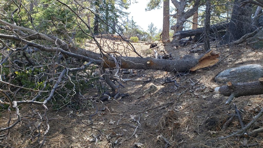
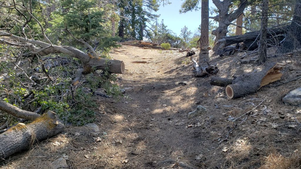
South Ridge Trail is clear of snow to Old Lookout Flat (7500 ft). Snow cover is about 30% on the traverse to 7800 ft but is then 70% to Tahquitz Peak with cleared patches increasing daily. There is a well-traveled posthole track to 8500 ft (switchback 12, for those very familiar with this trail) at which point the track largely goes directly to the Peak, rarely following the established trail route. Most hikers will find spikes and/or an ice axe very useful on the upper trail. The Trail Report cleared the significant treefall hazards on South Ridge Trail in mid April.
The Peak Trail track that I broke on 6th April has been well-traveled and fairly accurately follows the true trail route. However near Miller Peak at about 10,400 ft the track ascends directly up the East Ridge route, rather than following the Peak Trail switchback, as is traditional in winter conditions. The East Ridge section gets covered over regularly by light spindrift whenever winds are strong (such as 13th-14th April), but the underlying track remains largely visible.
The 0.4 mile section of South Ridge Trail between Chinquapin Flat/PCT MIle 177 and Tahquitz Peak has no track to follow at this time [surveyed multiple times in April] through several feet of heavily drifted and angled ice and icy snow. This ice slope is notoriously treacherous. Neither snowshoes nor spikes are helpful at this time, due to the angled slope and structure of the snow, respectively. Crampons with an ice axe are essential on this section at this time, along with the necessary skills and experience to use that equipment in icy, angled terrain with considerable exposure.
Deer Springs Trail is clear of snow to the Suicide Rock junction, and largely clear from there to Strawberry Junction, with just a few snow patches increasing in frequency close to the latter. Spikes are not needed to that point. Above Strawberry Junction snow cover is largely continuous, with just a few small patches starting to clear just north of the junction. There is a relatively well-traveled but uneven posthole track to the junction with Marion Mountain Trail. From there the route is largely an ugly posthole track that does not accurately follow the trail route in many places. Above the Fuller Ridge Trail junction the track rarely follows the trail route, and often diverges into two or even three options. All of them will ultimately get you to Little Round Valley however. The tracks largely coalesce briefly through Little Round Valley. From the upper end of Little Round Valley to San Jacinto Peak there are several indistinct posthole tracks that all climb directly up the slope, and none closely approximate to the true trail route. Spikes are recommended, especially for descending the upper trail, along with cautious navigation.
Marion Mountain Trail is largely clear of snow below 7200 ft elevation. Above that the trail has a lightly-traveled and uneven posthole track that largely follows the true trail route through largely continuous icy snow (c.80% snow cover). Spikes are useful, especially for descending.
Spitler Peak Trail suffered badly during ice storms in early February, and I found 34 new treefall hazards down during my surveys in late February, almost all in the upper half. Most are relatively small and readily passable, but a few are larger, and the combined effect is to make for a slower and scrappier hike.

PACIFIC CREST TRAIL
Snow cover on the PCT is minimal from Miles 151 (Highway 74) to about 163. Old icy snow is now very patchy and largely confined to north- and east-facing slopes, until about Mile 174.5. Note that many of these patches remain icy and require considerable caution. See comments below regarding specific conditions around Apache Peak (Mile 169.5). The posthole track on the north side of Red Tahquitz (175-177) does not accurately follow the PCT route.
Snow cover is then extensive, but with snow-free patches increasing every day, between Miles 175-192. The south-facing slopes at Miles 179-180 and 181-183 are now largely clear of snow.
At this time, nobo hikers unfamiliar with hiking across areas of angled icy snow may want to consider taking the alternate at Spitler Peak Trail (Mile 168.5) to avoid the worst of the snow slopes from Miles 169-178, and the 100+ downed treefall hazards in the same section. This situation is improving daily with warming and rapid melting expected daily from Tuesday 16th April onwards.
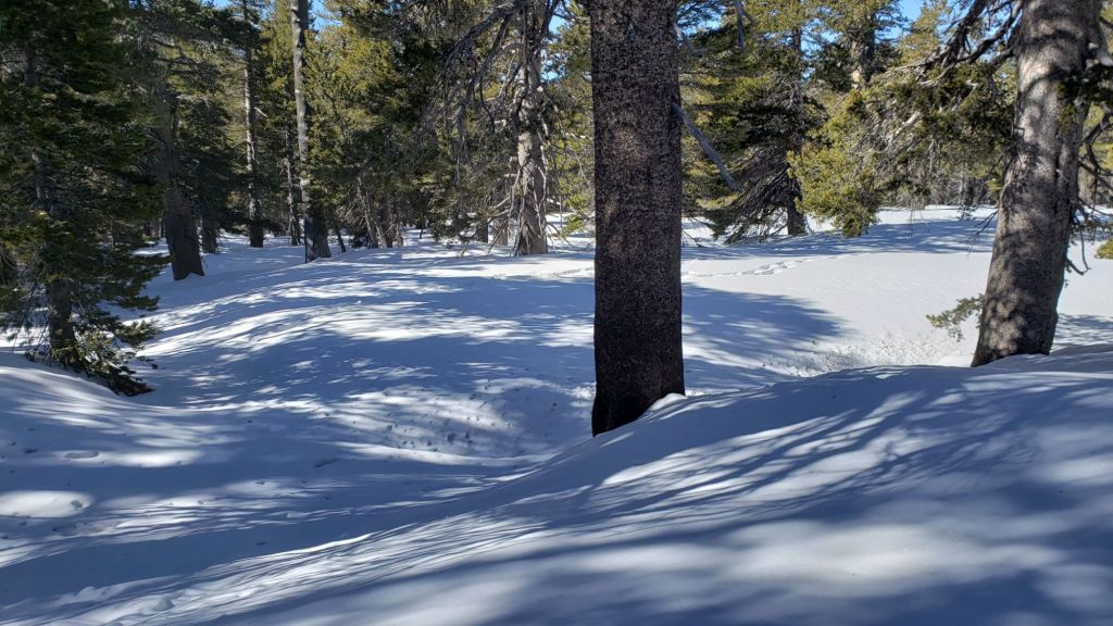
There is now a relatively reliable posthole track to follow on Fuller Ridge (Miles 185.5-191). Although it does not accurately the PCT route in several places, following the main track is the safest way to traverse these miles. Traversing this section is possible barebooting but spikes are strongly recommended. Also useful are patience, cautious navigation, and an adequate comfort level with hiking on angled icy snow slopes. I thoroughly surveyed Fuller Ridge on the morning of Thursday 18th April and reported on conditions in a short video report available here on YouTube.
It is recommended that hikers wanting to avoid Fuller Ridge until the ice conditions improve (now likely in the next week or two) use the Black Mountain Road alternate. Black Mountain Road is open to hikers but not to vehicle traffic at this time. Spikes are no longer required on the upper three miles of Black Mountain Road.
Only a small and patchy icy snow slope remains on the north-east side of Apache Peak. Spikes are recommended to traverse this short section using the PCT route. Another option for nobo hikers is to go up and over the saddle between the double peaks of Apache for those wanting to avoid this traverse.
PCT hikers should not attempt to use South Ridge Trail from the PCT at Chinquapin Flat (roughly Mile 177.7) to Idyllwild via Tahquitz Peak, even though this looks temptingly simple on apps and maps. There are no steps to follow through a lengthy section of steeply angled (and notoriously treacherous) ice slopes (photo below). Crampons, always with an ice axe, and expert knowledge of how to use this equipment on high angle terrain, are critical. Even in below average snow years like 2024 these slopes always take many weeks longer to clear of ice than adjacent areas, and they will remain challenging into late April this year, possibly even May.
PCT hikers are politely reminded that overnight stays are not permitted at or near San Jacinto Peak, including in the historic shelter. Mt. San Jacinto State Park regulations do not permit overnight stays in the shelter, which is dedicated for emergency, SAR, and ranger use.
Although just outside the region covered by the Trail Report (and my area of expertise) I understand that northbound hikers are experiencing significant problems due to storm damaged trail in the Mission Creek area of roughly Miles 225-250. More details are available at this link.
While all time and labor is volunteered, the San Jacinto Trail Report uses small private donations to help cover operating costs. Every year seems to have its unique challenges, and clearly 2024 will be no exception. Your contribution keeps the Report available to all, free from advertising or paywalls, and independent from agencies. If you have found this Report useful, please consider using this link to the Donate page. Thank you very much for your support.

SNOW DEPTHS measured on 15th April 2024 are as follows. The first number gives current average total depth, which also accounts for substantial melting between recent storms. The number in parentheses gives new snow recorded in the minor storm on 13th-14th April, while the number in brackets is the greatest depth at that location this winter (where known). Note that averages are given; due to strong winds during and after most storms there has been considerable drifting, plus often very uneven melting during warm interludes. Altitudes and PCT mileages are approximate.
San Jacinto Peak (10810 ft): 50-52 inches (1.0 inch new snow 13th April)[60 inches on 1st April]
Little Round Valley (9750 ft): 35-40 inches (1.0 inch new on 13th April)
Wellman Divide (9700 ft): 31-33 inches (0.75 inch new 13th April) [41-43 inches on 8th February]
Annie’s Junction/approx. PCT Mile 181.8 (9070 ft): 46 inches (1.0 inch new on 13th-14th April)[55 inches on 1st April]
Long Valley (8400 ft): 0-8 inches, very uneven melting (0.5 inch new 13th April)[24 inches on 8th February]
Strawberry Junction/PCT Mile 183 (8100 ft): 0-5 inches, rapidly melting (1.0 inch new on 13th-14th April)
Saddle Junction/PCT Mile 179.9 (8070 ft): 22-24 inches (1.0 inch new on 13th-14th April)[32 inches on 1st April]
Devil’s Slide Trail at Humber Park (6550 ft): 0-2 inches (0.25 inch new on 14th April)[15 inches on 8th February]
Idyllwild (at 5550 ft): 0 inch (no new snow on 13th April)[9 inches on 8th February]