UPDATE Sunday 24th March 2024: starting yesterday we have had a minor storm roll through as forecast. Today I broke trail – through moderate blizzard conditions up to 9100 ft – to San Jacinto Peak via Devil’s Slide, PCT, Wellman, Peak, and East Ridge trails to assess the snowfall and impact to the trails. New snow quantities were limited, with the most being four inches at Annie’s Junction (9070 ft, PCT Mile 180.8) and generally 2-3 inches from Idyllwild (at 5500 ft ) to San Jacinto Peak (10,810 ft). However strong winds accompanied the snowfall, and the drifting fine powder had completely eliminated tracks all the way down to 6500 ft. I discussed the conditions and current challenges for PCT hikers in a short video report recorded just below San Jacinto Peak late this morning (available here). I also uploaded a very brief panorama video from the Peak (available here) on what was an especially pretty morning. It is worth noting that the windchill temperature at the Peak was a brisk -12.5°F (-25°C). With the forecast of further light snow tonight, the next comprehensive Report update is planned for the evening of Monday 25th March.

UPDATE Friday 22nd March 2024: as forecast a minor storm rolls in tomorrow, Saturday 23rd. Two storm phases are expected, on Saturday afternoon/night, and again on Sunday afternoon/night. Both phases are expected to bring similar precipitation, with cold temperatures and hence a relatively low snow level near 5000 ft. A mixture of light rain and an inch or two of snow is possible in Idyllwild, with 1-3 inches of snow tentatively forecast for both Saturday and Sunday. In combination with strong winds, drifting snow may largely obscure tracks in the high country (>8000 ft especially). Suitable equipment and cautious navigation will be required throughout 23rd-25th at least.
————————————-
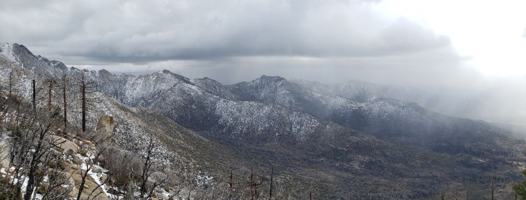
This is a summary of conditions following an unusual and lengthy storm that has impacted the San Jacinto mountains from 14th-19th March 2024. A stationary low pressure system centred over the Arizona/California border produced most precipitation on 14th-15th, but then periodic thunderstorms, most notably on 18th, have continued for days.
For the main storm on 14th-15th, the forecasts greatly underestimated the volume of snow that actually fell. The greatest depth I measured on 16th March was 12 inches at Wellman Divide (9700 ft), but locations ranging from Humber Park (6500 ft) to San Jacinto Peak (10,810 ft) all had at least nine inches. Even Idyllwild reached six inches (almost fully melted by 16th), and it dusted as low as 4000 ft in Anza.
On Monday 18th March there were periodic graupel storms throughout the mountains, with a dusting as low 6800 ft, and on 19th I measured about one inch of new snow above 7500 ft, and two inches above 9500 ft all the way to San Jacinto Peak.
The snow from the first wave on 14th-15th was probably the lightest powder I have ever experienced in these mountains, with an extremely low water content. With the storm coming in, unusually, from the north-east, the snow was dry “continental” powder, in contrast to the “maritime” (high water content) snow we typically get from westerly directions. This made for superb snowshoeing conditions. It also meant there was no ice from rain on trees at mid elevations, nor any rime at higher elevations, so there will not be the usual hazards of ice falling from trees nor fallen ice obscuring tracks once melting is underway.
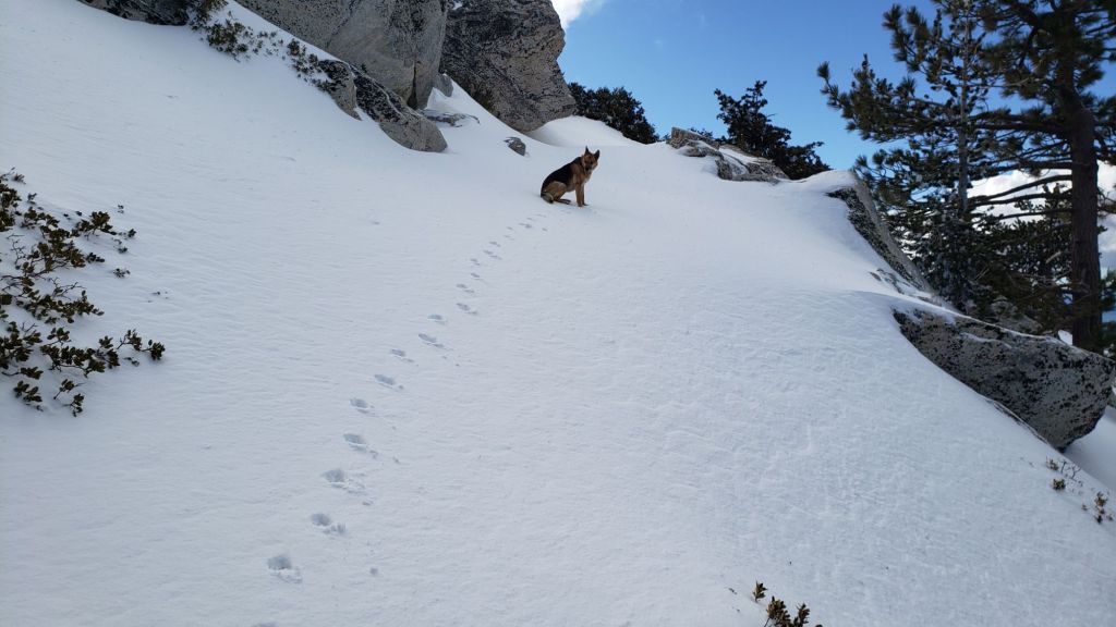
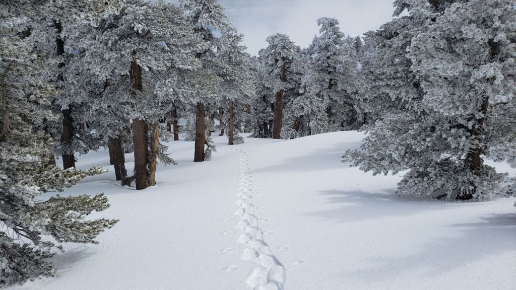
Snow depths initially eliminated all pre-existing tracks above 6000 ft. Tracks put in over the weekend were erased again by drifting snow and the fresh graupel by Tuesday 19th. On Saturday 16th I broke trail up Devil’s Slide Trail and onward from Saddle Junction to San Jacinto Peak via the Wellman, Peak, and East Ridge trails. On Tuesday 19th I found those tracks had survived well as far as 9000 ft, but I had to break trail (snowshoeing) from Annie’s Junction (9070 ft) through to San Jacinto Peak again. On 18th we finished breaking trail to Tahquitz Peak via South Ridge Trail, but those tracks may not have survived the minor snow storms and winds of later that day.
On the morning of Tuesday 19th March I recorded a rambling video discussion of the situation at that time from San Jacinto Peak (available here).
Snowshoes remain invaluable everywhere above about 8000 ft elevation (see photos below). This elevation may rise rapidly to 9000 ft with melting expected this week, and as trails become compacted and increasingly suited to spikes and/or crampons.
Tracks remain very icy in places under the fresh powder. I had confirmation from PCT hikers (with considerable mountaineering experience) of dangerous ice under powder on Fuller Ridge on 17th-18th. On 10th and 11th I saw widespread evidence of significant hiker falls throughout the high country trails (example photos in previous Report linked here).
For the next week – until thawing is expected to be partly underway – spikes at a minimum (preferably crampons in some areas) are recommended everywhere above 7500 ft. Crampons are required on the north side of Tahquitz Peak and on Fuller Ridge, as discussed below, and may become increasingly useful everywhere in the high country for the remainder of March (at least).
Daily survey hikes in the San Jacinto mountains include various routes to San Jacinto Peak multiple times per week (most recently on 10th, 11th, 16th, and 19th March), Tahquitz Peak and area at least once per week (most recently on 12th and 18th March), Apache Peak area at least weekly (during PCT season), plus a wide variety of other trails on intervening days.
Details of snow depths measured at various locations on the trail system are given at the foot of this posting. Note however that snow depth itself is very rarely indicative of the difficulty (or ease) of hiking a particular track or trail. For example a well-traveled and defined track across snow several feet deep is often much easier hiking than a lightly traveled track across just a few inches depth of angled icy snow. PCT hikers in particular should note that many high country trails potentially pose greater risks in 2024 (due to underlying ice from prior rain-on-snow) than they did at the same time in 2023 when snow depths were triple those of this year.
Despite generally warming temperatures for the next few days, hikers should be prepared for temperatures below freezing at higher elevations, and often well below freezing when considering wind chill effects. See Weather section below for some of my recent observations from San Jacinto Peak.
Black Mountain Road is closed to vehicle traffic due to winter conditions at the gate 1.7 miles up from Highway 243. The road is quickly clearing as far as the turning to Boulder Basin five miles from the highway. Snow cover on the road will remain largely continuous from there for the next three miles to the PCT crossing/Fuller Ridge campground into late March.
Humber Park closed again on 15th March. Even when closed, there are nine legal parking spaces just below the gate (Adventure Pass or equivalent still required). South Ridge Road is closed due to winter conditions. Azalea Drive – access to Marion Mountain trailhead – is clear of snow. Dark Canyon Road has been closed almost continuously for the past five years.
WEATHER
Temperatures rapidly warm to near or above seasonal for 19th-22nd March, and melting will be rapid everywhere below 7500 ft plus on sun-exposed slopes at higher elevations. The next minor storm system is expected around 23rd-25th March. Precipitation amounts at various elevations are currently unclear, but may be limited to 1-6 inches of snow in the high country and a mix of light rain and snow at mid elevations (e.g., Idyllwild). At this time, temperatures are tentatively forecast to rise again from 26th onwards.
At San Jacinto Peak (3295m/10,810ft) on Tuesday 19th March 2024 at 1020 the air temperature was 23.2°F (-5°C), with a windchill temperature of 5.9°F (-14°C), 92% relative humidity, and a gusty due North wind sustained at 14 mph gusting to 21.1 mph.
At the Peak on Saturday 16th March 2024 at 1005 the air temperature was 17.4°F (-8°C), with a windchill temperature of -1.3°F (-19°C), 93% relative humidity, and a bitter due North wind sustained at 12 mph gusting to 19.5 mph.
At the Peak on Monday 11th March 2024 at 0850 the air temperature was 23.6°F (-5°C), with a windchill temperature of 4.8°F (-15°C), 55% relative humidity, and a stiff due West wind sustained at 19 mph gusting to 23.7 mph.
TRAIL CONDITIONS
There is largely continuous snow cover on all trails above about 6800 ft, with rapidly melting and increasing patchy snow locally to 8000 ft on the most sun-exposed slopes. Under the moderate depth fresh powder, the remaining old snow is firm and icy. Icy snow requires considerably more caution plus specialist equipment (and different physical and mental skillsets) than soft, postholing snow. Snow quality will start to deteriorate this week with a warming trend and locally rapid melting at all elevations.
Some major tracks have been broken through the snow at this time including South Ridge Trail south of Tahquitz Peak, Devil’s Slide Trail, onward via the PCT, Wellman and Peak trails to San Jacinto Peak, from Long and Round valleys up to Wellman Divide.
Carrying spikes is strongly recommended everywhere above about 6500 ft. Icy compacted snow – once the trails become well-traveled – will be largely ideal for spikes, although as discussed above crampons are an excellent option until next week at least, especially in some locations above about 7700 ft. Crampons are essential if attempting Fuller Ridge and the north side of Tahquitz Peak (discussed below).
Snowshoes can be valuable everywhere above about 7500 ft elevation at present. On warm days (most likely 19th-22nd March) and later in the day on sunny slopes they will become increasingly helpful. They will quickly become less useful for on-trail travel below 9000 ft as the established tracks become well compacted. Snowshoes will be recommended for any significant off-trail travel away from the defined tracks in the high country into April.
Despite limited snow this season and being readily passable with the appropriate skills and equipment for angled icy snow (currently crampons plus ice axe recommended), the State Park closed the uppermost section of Skyline Trail in their jurisdiction (above about 5600 ft) starting 21st February due to perceived unsafe conditions.
Devil’s Slide Trail is clearing below 7000 ft but is otherwise snow-covered above that elevation. However melting is underway on 16th and it will largely clear of snow up to 6800 ft this week, with patchy clearing to 7500 ft, and some bare patches appearing as high as 8000 ft. The track is already well-defined and compacted. Note that at about 7700-7900 ft there can be very icy conditions around switchbacks 6-8 (for those who are very familiar with this trail). Spikes are ideal for this trail, although they are not essential. The Trail Report undertook extensive trail maintenance work on 15th February to remove many damaged tree limbs in and over the trail resulting from an early February ice storm.
The Peak Trail track that I broke on 16th and 19th March quite accurately follows the true trail route. However near Miller Peak at about 10,400 ft the track ascends directly up the East Ridge route, rather than following the Peak Trail switchback, as is traditional in snow conditions.
South Ridge Trail [surveyed 18th March] now has a broken track through light to moderate snow to Tahquitz Peak. Snow cover is about 90% and generally thin to Old Lookout Flat at 7500 ft. This will melt rapidly and will probably be only 20% by the weekend. From there snow cover is continuous, and will remain at least 90% for at least the next week. The posthole track up the switchbacks is relatively rough and uneven, but almost exactly follows the trail route. Barebooting is fine at present, but with freeze-thaw cycles and compaction spikes (at least) will become increasingly useful. South Ridge Road (gate closed) is rapidly clearing of snow and the few remaining patches are very thin.
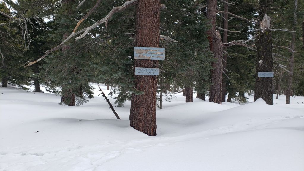
The 0.4 mile section of South Ridge Trail between Chinquapin Flat/PCT MIle 177 and Tahquitz Peak has no track to follow at this time [surveyed 18th March] through several feet of heavily drifted and angled ice and icy snow. This ice slope is notoriously treacherous. Neither snowshoes nor spikes are helpful at this time, due to the angled slope and structure of the snow, respectively. Crampons with an ice axe are essential on this section at this time, along with the necessary skills and experience to use that equipment in icy, angled terrain.
Spitler Peak Trail suffered badly during the ice storms in early February, and I found 34 new treefall hazards down during my surveys in late February, almost all in the upper half. Most are relatively small and readily passable, but a few are larger, and the combined effect is to make for a slower and scrappier hike.
PACIFIC CREST TRAIL
Current snow cover on the PCT is limited and rapidly melting from Miles 151 (Highway 74) to about 163. Underlying snow is then thin and patchy, largely confined to north- and east-facing slopes, until about Mile 174. Note that many of these patches are icy and require considerable caution. See comments below regarding specific conditions around Apache Peak (Mile 169.5). Snow cover is then functionally continuous between Miles 174-194. There are currently no reliable tracks to follow on Fuller Ridge (Miles 185.5-191) and traversing this section requires crampons, an ice axe, and appropriate snow skills (a track that was put in on 17th-18th March is probably largely covered in drifted snow at this time).
At this time, nobo hikers should strongly consider taking alternates at either Fobes Trail (Mile 166) or Spitler Peak Trail (Mile 168.5) to avoid the worst of the icy snow slopes from Miles 169-175. This situation will continue to change over the coming days and weeks with steady (or even rapid) melting expected in the remainder of March.
It is recommended that hikers use the Black Mountain Road alternate to avoid Fuller Ridge until the ice conditions improve (likely by the end of March). Black Mountain Road is open to hikers but not to vehicle traffic at this time. Spikes are useful (but not essential) on the upper three miles of Black Mountain Road.
A significant icy snow slope remains on the north-east side of Apache Peak (photo in prior Report linked here). At this time spikes at a minimum, but preferably crampons, plus an ice axe, and crucially the skills and experience to use this equipment on angled icy snow, are required to traverse this section. While one option for nobo hikers is to go up and over the saddle between the double peaks of Apache to avoid this traverse, there are further very icy chutes and slopes in the next few miles, especially at present around Red Tahquitz (Miles 174-175.5), some of which have proven to be equally problematic in past seasons. Alternates at Miles 166 and 168.5 are recommended, as mentioned above.
PCT hikers should not attempt to use South Ridge Trail from the PCT at Chinquapin Flat (roughly Mile 177.7) to Idyllwild via Tahquitz Peak, even though this looks temptingly simple on apps and maps. There are no steps to follow through a lengthy section of steeply angled (and notoriously treacherous) ice slopes. Crampons, always with an ice axe, and expert knowledge of how to use this equipment on high angle terrain, are critical. Even in low snow years like 2024 these slopes always take many weeks longer to clear of ice than adjacent areas, and they will remain challenging into April this year.
Although outside the region covered by the Trail Report (and my area of expertise) I understand that northbound hikers are experiencing significant problems due to storm damaged trail in the Mission Creek area of Miles 225-250. More details are available at this link.
SNOW DEPTHS measured on 16th March 2024 are as follows. The first number gives current average total depth. The number in parentheses gives new snow from the storm on 14th-15th March, while the number in brackets is the greatest depth at that location this winter (where known). Note that averages are given; due to strong winds during and after most storms there has been considerable drifting, plus often uneven melting. Altitudes and PCT mileages are approximate.
San Jacinto Peak (10810 ft): 45-46 inches (9 inches new snow 14th-15th March)[55-60 inches on 8th February]
Wellman Divide (9700 ft): 30-34 inches (12 inches new 14th-15th March) [41-43 inches on 8th February]
Annie’s Junction/approx. PCT Mile 181.8 (9070 ft): 45 inches (11 inches new on 14th-15th March)[48-50 inches on 8th February]
Long Valley (8400 ft): 8-12 inches (8 inches new 14th-15th March)[24 inches on 8th February]
Saddle Junction/PCT Mile 179.9 (8070 ft): 20 inches (10.5 inches new on 14th-15th March)[31 inches on 8th February]
Devil’s Slide Trail at Humber Park (6550 ft): 5-10 inches, already rapidly melting (9 inches new on 14th-15th March)[15 inches on 8th February]
Idyllwild (at 5550 ft): 0-2 inches, already largely melted (6 inches new on 14th-15th March)[9 inches on 8th February]
Mountain Center (4400 ft): 0 inches, melted (2 inches new on 14th-15th March)[3 inches on 9th February]
While all time and labor is volunteered, the San Jacinto Trail Report uses small private donations to help cover operating costs. Every year seems to have its unique challenges, and it is already clear that 2024 will be no exception. Your contribution keeps the Report available to all, free from advertising or paywalls, and independent from agencies. If you have found this Report useful, please consider using this link to the Donate page. Thank you very much for your support.