UPDATE Thursday 7th March 2024 at 1530: Following yet another minor storm overnight, I broke trail through light snow from Humber Park to San Jacinto Peak this morning and have uploaded a short video discussion from there (linked here), where there were three inches of fresh snow. Most snow fell in the early hours of this morning, at least on the western slope, with one inch in Idyllwild (now melted), 1.5 inches at Humber Park (largely melted), 3.5 inches at Saddle Junction, four inches at 9000 ft, but only 2.5 inches at Wellman Divide. Existing tracks were largely visible below 9000 ft, and this should be true throughout the mountains. Tracks are dangerously icy in places under the thin fresh powder. For at least the next 24-48 hours until thawing is well underway, crampons are strongly recommended (or spikes at a minimum) everywhere above 7500 ft. Tracks above 9000 ft have been largely erased by drifting snow. I put in a reliable track on the Wellman, Peak and East Ridge trail routes this morning, but saw no other tracks on any other trails today. I will not be doing a full update until next week as melting will be very rapid in the next few days, and conditions will soon revert to those described in the Report below. Humber Park reopens on Saturday 9th March.
UPDATE Wednesday 6th March 2024 at 1830: Contrary to forecasts – that had predicted rain initially at mid elevations – it abruptly started snowing across the San Jacinto mountains this afternoon, starting at 1540 in Idyllwild. Although heavy at times, it has struggled to settle, with a patchy 0.25 inch accumulating in Idyllwild in three hours, and about the same at 8600 ft in Long Valley. More is expected over the next 2-3 hours, before tailing off, with now less than an inch total expected at mid elevations, and only 1-2 inches in the high country.
——————————
In keeping with the theme of this winter – in which many storms have frustratingly passed by the San Jacinto mountains to the north or west – the latest storm system on 2nd-3rd March produced moderate rain at mid elevations rather than the very heavy snowfall widely reported further north. Conditions in the upper atmosphere were such that the San Jacinto high country remained largely above the cloud, with no significant new snow added. Idyllwild (at 5550 ft) received 1.31 inches of rain over the two day period.
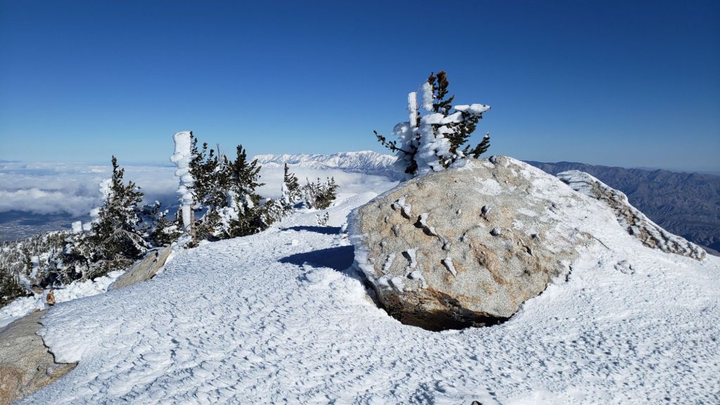
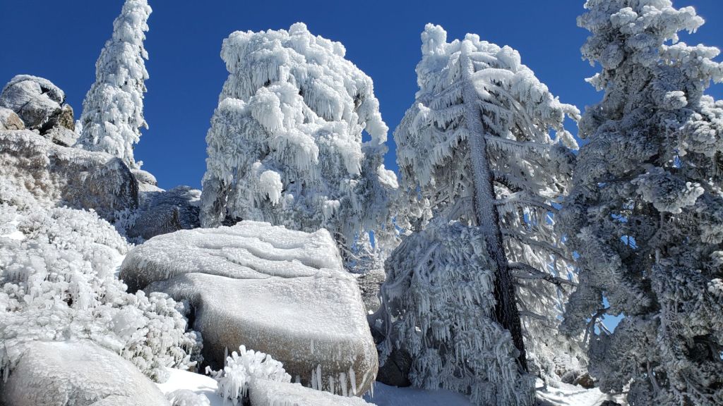
Most striking on our hike up South Ridge Trail yesterday and to San Jacinto Peak this morning was how everything below 9800 ft was plastered with ice from freezing rain (see photos below). The clear ice indicative of rain transitioned between 9000-10,000 ft into rime ice (formed by supercooled water droplets in clouds) (visible in the Peak photo near the foot of this posting).
Daily survey hikes in the San Jacinto mountains include various routes to San Jacinto Peak multiple times per week (most recently on 26th and 29th February, and 4th March), Tahquitz Peak and area at least once per week (most recently on 3rd March), Apache Peak area at least weekly at this time of year (most recently on 25th February), plus a wide variety of other trails on intervening days.
Snow conditions have improved with cooler weather this week, especially above 7500 ft, in contrast to the soft, unpredictable snow of last week. However hard, icy snow requires considerably more caution (and a different skill set) than soft, postholing snow. Snow quality should stabilize with temperatures remaining cool until about Saturday 9th March when a spring-like warming trend is expected.
Both the ice and strong winds associated with the storm have significantly hardened tracks, and consequently for the next 24-48 hours (at least) until thawing is well underway, spikes at a minimum, but preferably crampons, are recommended everywhere above 7000 ft.
Details of recommended traction devices are given below under Trail Conditions. In summary, carrying spikes is recommended everywhere above about 6500 ft, even if using other traction devices as well. Crampons are currently useful everywhere in the high country above about 7500 ft (possibly lower) over the next week as the pre-existing snow firms up in colder temperatures and following both freeze-thaw cycles and compaction. Crampons are required on the north side of Tahquitz Peak (details below). Snowshoes can be useful above about 8000 ft elevation, especially on warmer, sunnier days (i.e. from 9th March onwards), and from late morning as snow softens on sun-exposed slopes. They will be invaluable for any off-trail travel above 8000 ft once snow softens (currently such areas generally require crampons).
Details of snow depths measured at various locations on the trail system are given at the foot of this posting. Note however that snow depth itself is very rarely indicative of the difficulty (or ease) of hiking a particular track or trail. For example a firm, well-defined track across snow several feet deep is often much easier hiking than a lightly traveled track across just a few inches depth of angled icy snow.
Light precipitation is forecast for 6th-7th March. It is tentatively forecast to be another relatively mild system, with rain in the afternoon/evening of both Wednesday 6th and Thursday 7th. Currently 2-6 inches of snow are possible at the uppermost elevations.
Temperatures will be relatively cool for the first week or so of March. Hikers should be prepared for temperatures below freezing at higher elevations, and well below freezing when considering wind chill effects. See Weather section for some of my recent observations from San Jacinto Peak.
Humber Park closed on 31st January but is expected to reopen Saturday 9th March (per USFS). Even when closed, there are nine legal parking spaces just below the gate (Adventure Pass or equivalent still required). South Ridge Road is closed due to winter conditions. Azalea Drive – access to Marion Mountain trailhead – is clear of snow. Dark Canyon Road has been closed almost continuously for the past five years.
Despite limited snow this season and being readily passable with the appropriate skills and equipment for angled icy snow (currently crampons and ice axe), the State Park closed the uppermost section of Skyline Trail in their jurisdiction (above about 5600 ft) starting 21st February due to perceived unsafe conditions.
WEATHER
Temperatures remain below seasonal this week and then drop further when the next storm comes through on 6th-7th March. This system is again forecast to be very minor, with light rain expected throughout the mid elevations and the possibility of very light snow above about 5500 ft. Upper elevations may receive 2-6 inches of snow. The precipitation is expected in two waves, mainly on Wednesday evening, and then Thursday afternoon.
Temperatures then rise abruptly to above seasonal starting Friday 8th March, and are forecast to be spring-like for the middle two weeks of March. Air temperatures above 10,000 ft may be near or above freezing day and night, resulting in rapid melting and significant deterioration in snow conditions.
At San Jacinto Peak (3295m/10,810ft) on Thursday 7th March 2024 at 1020 the air temperature was 17.8°F (-8°C), with a windchill temperature of 1.4°F (-17°C), 89% relative humidity, and a steady due North wind sustained at 9 mph gusting to 14.5 mph.
At the Peak on Monday 4th March 2024 at 0830 the air temperature was 23.3°F (-5°C), with a windchill temperature of 5.7°F (-15°C), 67% relative humidity, and a brisk NW wind sustained at 12 mph gusting to 23.7 mph.
At the Peak on Thursday 29th February 2024 at 0830 the air temperature was 24.4°F (-4°C), with a windchill temperature of 7.9°F (-13°C), 38% relative humidity, and a steady WSW wind sustained at 15 mph gusting to 19.5 mph.
TRAIL CONDITIONS
There is increasingly patchy light snow cover on all trails between 6400-7000 ft, becoming largely continuous above about 6800 ft (except on the most sun-exposed trails such as lower Deer Springs) and then continuous everywhere and significantly deeper above about 7900 ft. Compacted tracks are now in place for most of the major trails (details below) however these are less distinct that last week due to drifting snow in strong winds at the weekend, and rain heavily icing the tracks. Snow depths measured at specific locations are given below.
Carrying spikes is recommended everywhere above about 7000 ft. The well-traveled trails are largely ideal for spikes at this time, although crampons are an excellent option until late morning at least, especially above about 9000 ft. It is possible for hikers with exceptional experience on angled icy snow to ascend above 9500 ft using only spikes (in conjunction with an ice axe), but crampons are the recommended option for most hikers.
Crampons are required on the north side of Tahquitz Peak (discussed below) and are now increasingly useful everywhere in the high country – especially for the relatively cool next 5-6 days – following freezing rain and as the snow undergoes freeze-thaw cycles and further compaction.
Snowshoes can be valuable everywhere above about 8000 ft elevation on warm days (i.e. starting 8th-9th March) and later in the day on sunny slopes. They are currently less useful on the established tracks which are well compacted, but that may change if new snowfall is sufficiently deep and/or warmer, sunnier weather. Snowshoes are recommended for any significant off-trail travel away from the defined tracks in the high country, other than on cold mornings when all high elevation snow is currently very firm.
Tracks known to be broken through the snow at this time include South Ridge Trail to Tahquitz Peak on the south side of the peak, Devil’s Slide Trail, onward via the PCT, Wellman and Peak trails to San Jacinto Peak, from Long and Round valleys up to Wellman Divide, Deer Springs Trail, and Marion Mountain Trail. There are currently no reliable tracks on Fuller Ridge Trail and Seven Pines Trail.
Devil’s Slide Trail is now clear of snow up to 6800 ft (switchback 3). Thereafter snow cover is largely continuous, with a well-defined, compacted track, best for either barebooting or for spikes all day. The Trail Report undertook extensive trail maintenance work on 15th February to remove many damaged tree limbs in and over the trail resulting from an early February ice storm.
Ernie Maxwell Trail is now functionally clear of snow, with just a handful of tiny patches remaining close to Humber Park.
There are very lightly traveled snowshoe tracks around the Tahquitz area meadows, but not generally accurately following the established trail routes. These have become somewhat obscured in the recent fresh snow. As of 29th February, a mixed posthole/snowshoe track is in place on Willow Creek Trail as far as the “King Trail”, continuing from there down to Laws.
The Peak Trail track now quite accurately follows the true trail route. However near Miller Peak at about 10,400 ft the track ascends directly up the East Ridge route, rather than following the Peak Trail switchback, as is traditional in snow conditions. Following strong winds on 2nd-3rd March, and rime ice fall under trees, the track is partly obscured in places and good route-finding skills are required.
Deer Springs Trail is functionally clear of snow up to the Suicide Rock junction (near 7000 ft). For the next 0.5 mile snow cover is about 40%, and then abruptly becomes about 90% snow covered above 7400 ft through to Strawberry Junction. This section has not been heavily traveled, so there is no well-compacted route but rather a postholed track through – on warm days and most afternoons – soft and locally deep snow on this largely sun-exposed slope. North from Strawberry Junction, the PCT initially has a lightly traveled posthole track, but after a mile most tracks disappear and only a barely traveled posthole track continues through to the top of Marion Mountain Trail (8700 ft).
Above Marion Mountain Trail, there is a well-traveled and compacted track mixing snowshoe, crampon, and spike tracks, and this solid track is currently ideal for spikes and/or crampons. The route largely follows the PCT to the Fuller Ridge junction. Thereafter the track only vaguely follows the Deer Springs Trail route up to Little Round Valley, but it gets you there. Above Little Round Valley the diminishing number of tracks fragments into a mess of at least half-a-dozen routes, none of which remotely follow the trail and all of which head more-or-less directly upslope (as is traditional in decent snow conditions).
Marion Mountain Trail has a compacted track to follow up to Deer Springs Trail, ideal for spikes. Snow is becoming very patchy in the first mile up to about 7000 ft, but is largely continuous thereafter. Although the track does not accurately follow the trail route in a few minor places, but again, it gets you up to the Deer Springs Trail junction.
The 0.4 mile section of South Ridge Trail between Chinquapin Flat/PCT and Tahquitz Peak has no track to follow at this time through 2-5 feet of heavily drifted and angled ice and icy snow. Neither snowshoes nor spikes are especially helpful at this time, due to the angled slope and structure of the snow, respectively. Crampons (always with an ice axe) are recommended on this section at this time, along with the necessary skills and experience to use that equipment in icy, angled terrain.
South Ridge Trail above South Ridge Road has only about 20% icy snow cover to Old Lookout Flat at 7600 ft. Unfortunately four new treefall hazards are down on that section. Snow cover is largely continuous thereafter to Tahquitz Peak. The angled snow is very icy above 8400 ft with a poorly defined track, requiring an ice axe with spikes (for the most experienced) or crampons (recommended for most hikers).
Spitler Peak Trail is clear of snow, however it suffered badly during the ice storms in early February, and I found 34 new treefall hazards down during my survey on 25th February, almost all in the upper half. Most are relatively small and readily passable, but a few are larger, and the combined effect is to make for a slower and scrappier hike.
Fobes Trail [surveyed 28th February] is completely clear of snow. There is one major stump down and half-a-dozen new minor treefall hazards, but none are significant obstructions for hikers.
Current snow cover on the PCT is minimal from Miles 151 (Highway 74) to about 163. Snow is then thin and patchy, largely confined to north- and east-facing slopes, until about Mile 174. See comments below regarding specific conditions around Apache Peak (Mile 169.5). Snow cover is then functionally continuous between Miles 174-194. There are currently no reliable tracks on Fuller Ridge (Miles 185.5-191). At this time, nobo hikers should consider taking alternates at either Fobes Trail (Mile 166) or Spitler Peak Trail (Mile 168.5) to avoid the worst of the icy snow slopes from Miles 169-175. This situation will continue to change over the coming days and weeks with a sequence of melting periods and minor storms alternating into mid March (at least).
A significant icy snow slope remains on the north-east side of Apache Peak (photo below). At this time spikes at a minimum, but preferably crampons, plus an ice axe, and crucially the skills and experience to use this equipment on angled icy snow, are required to traverse this section. While one option for nobo hikers is to go up and over the saddle between the double peaks of Apache to avoid this traverse, there are further very icy chutes and slopes in the next few miles, especially at present around Red Tahquitz (Miles 174-175.5), some of which have proven to be equally problematic in past seasons. Alternates at Miles 166 and 168.5 are recommended, as mentioned above.
PCT hikers should not attempt to use South Ridge Trail from the PCT at Chinquapin Flat (roughly Mile 177.7) to Idyllwild via Tahquitz Peak, even though this looks temptingly simple on apps and maps. There are no steps to follow through a lengthy section of steeply angled (and notoriously treacherous) ice slopes. Crampons, always with an ice axe, and expert knowledge of how to use this equipment on high angle terrain, are critical. Even in low snow years like 2024 these slopes always take many weeks longer to clear of ice than adjacent areas, and they are likely to remain treacherous into April this year.
SNOW DEPTHS measured on 4th March 2024 are as follows. The first number gives current average total depth. Reductions in totals since the last Report are due to melting and compaction. The number in parentheses gives the greatest depth at that location this winter (where known). Note that averages are given; due to strong winds accompanying most storms this winter there has been considerable drifting, plus considerable uneven melting. Altitudes and PCT mileages are approximate.
San Jacinto Peak (10810 ft): 38-40 inches (was 55-60 inches on 8th February)
Little Round Valley (9800 ft): 32-36 inches
Wellman Divide (9700 ft): 26-28 inches (was 41-43 inches on 8th February)
Annie’s Junction/approx. PCT Mile 181.8 (9070 ft): 36 inches (was 48-50 inches on 8th February)
Long Valley (8600 ft): 8 inches (was 24 inches on 8th February)
Strawberry Junction/PCT Mile 183 (8100 ft): 6 inches, ranging from 0-12.
Saddle Junction/PCT Mile 179.9 (8070 ft): 10 inches (was 31 inches on 8th February)
Devil’s Slide Trail at Humber Park (6550 ft): 0 inches (was 15 inches on 8th February)
Idyllwild (at 5550 ft): 0 inch (was 9 inches on 8th February)
Mountain Center (4400 ft): 0 inch (was 3 inches on 9th February)

While all time and labor is volunteered, the San Jacinto Trail Report uses small private donations to help cover operating costs. Every year seems to have its unique challenges, and it is already clear that 2024 will be no exception. Your contribution keeps the Report available to all, free from advertising or paywalls, and independent from agencies. If you have found this Report useful, please consider using this link to the Donate page. Thank you very much for your support.