Tropical Storm Hilary became the first such storm to make landfall in California in 84 years, and its impacts were felt across our region on 19th-20th August. Indeed the remnants of the eye of former Hurricane Hilary actually traveled northward directly over the San Jacinto mountains late on Sunday 20th, bulldozing heavy precipitation ahead of it, along with gusty winds.
Rain that had been forecast to start on Saturday morning ultimately did not impact most of the mountain range until Sunday 20th August. The notable exception was on the east side, where thunderstorms over Long Valley (8600 ft) produced 2.3 inches of rain on 19th, while Idyllwild, only a few miles away, recorded no rain that day.
The southern and western slopes did not receive any rain until the early hours of Sunday 20th, and the rain only intensified in the afternoon of 20th. Nevertheless, the final two day storm rainfall totals were impressive, with 4.30 inches in Idyllwild (measured at 5550 ft), 6.10 inches at Saddle Junction (8100 ft), 8.25 inches at San Jacinto Peak (measured at 10,700 ft), and a remarkable 11.74 inches in Long Valley (8600 ft). The rainfall from Hilary was much appreciated, and has certainly helped suppress and shorten our fire season.
Winds were much less impressive, and did not match those of Tropical Storm Kay that passed offshore Southern California in early September last year. Gusts at 50-55 mph were recorded in Apple Canyon, and just outside our area a gust of 61 mph was measured at Whitewater.
Daily survey hikes include many different routes to San Jacinto Peak multiple times per week, most recently on 21st, 23rd, and 25th August, plus a wide variety of other trails on intervening days. A sample of my recent weather observations from San Jacinto Peak is given in the Weather section below. The trail system has been clear of snow since mid July.
There is currently a large volume of water and treefall debris in the trails following Tropical Storm Hilary, although the impacts could have been much worse. All trails have minor washouts, but nothing unduly problematic. The only trail surveyed so far with major treefall damage is Willow Creek Trail (details below), which had only just been cleared of nearly 70 trees accumulated over three years of neglect.
Hikers in summer should be prepared for rapidly changing weather conditions in the high country. Monsoon thunderstorms are forecast as a possibility on several days for the next two weeks. Lightning, brief but intense precipitation, and rapid temperature drops can occur in the high country even when such storms are not forecast for lower elevations.
In the summer (and from 26th-30th August in particular) hikers should also be prepared for temperatures above seasonal in the high country. Give considerable extra thought to route choice, start times, clothing, sun protection, and hydration requirements.
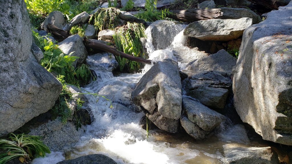
Water sources such as creeks, pipes, and springs are flowing extremely well (see below for some “before-and-after” storm photos, and also photos in the prior Report linked here). Even after the brief boost from the heavy rainfall of recent days subsides, flow rates will continue to be well above the average of the last decade. Consequently in contrast to most recent years I am not reporting water flow details for specific locations at this time. This summer has seen the most water on the mountain since 1998 (following the great El Niño winter of 1997/98), even prior to the effects of Tropical Storm Hilary. Hidden Lake was refilled by Hilary, having been about 50% full by volume immediately prior to the storm (photo below).
Given the intensity of this past winter, and the wind and rain of Tropical Storm Hilary, hikers should expect to encounter new treefall hazards and considerable fresh debris, on trails. Trails are slowly being cleared, largely by volunteers, as described in Trail Conditions below.
Be rattlesnake aware. Southern Pacific Rattlesnakes Crotalus (oreganus) helleri were active on the trail system up to 9300 ft prior to Tropical Storm Hilary, and will likely reappear soon once temperatures warm again in the next few days. Above about 5000 ft, the venom of this rattlesnake species in the San Jacinto mountains is predominantly neurotoxic, almost always fatal for dogs and sometimes for humans (see my 2020 article here for further information). Devil’s Slide and lower Deer Springs trails, Suicide Rock, around Strawberry Cienega, and trails near Tahquitz Peak are common locations for sightings.
Black Mountain Road (4S01) was in its poorest condition for at least a decade this spring. The partial grading undertaken on 17th July improved the situation somewhat, but it remained a bumpy drive which will have been worsened by the rains of Tropical Storm Hilary. Forest Service roads Dark Canyon Road (4S02) and South Ridge Road (5S11) remain closed to vehicles. Dark Canyon campground and the South Ridge yellow post sites remain closed. The State Park campground at Stone Creek is temporarily closed due to maintenance issues following Hilary.
The annual maintenance closure of the Palm Springs Aerial Tramway is currently underway, with a scheduled reopening on 1st September 2023. See the Tramway website for further details.
Due to major road work at the uppermost end of Fern Valley Road, Humber Park parking area will be completely closed to all traffic for two weeks in October 2023 (exact dates currently unknown). In general be prepared for possible disruption accessing trailheads around Idyllwild throughout August-October due to resurfacing work on lower Saunders Meadow and Fern Valley roads and North Circle and South Circle drives.

WEATHER
Tropical Storm Hilary produced the heavy rainfall that was widely forecast, and gusty (but not damaging) winds reminiscent of a typical Santa Ana event. The remnants of the eye of former Hurricane Hilary traveled south-north directly across the San Jacinto mountains late on Sunday 20th, bulldozing heavy precipitation ahead. Rain that had been forecast to start on Saturday morning ultimately did not impact most of the mountain range until Sunday 20th. The notable exception was on the east side, where thunderstorms over Long Valley (8600 ft) produced 2.3 inches of rain on 19th, while Idyllwild, only a few miles away, recorded no rain that day.
The southern and western slopes did not receive any rain until about 0200 on Sunday 20th, intensifying in the afternoon of 20th. The final two day storm rainfall totals were impressive, with 4.30 inches in Idyllwild (measured at 5550 ft), 6.10 inches at Saddle Junction (8100 ft), approx. 8.25 inches at San Jacinto Peak (measured at 10,700 ft), and a remarkable 11.74 inches in Long Valley (8600 ft).
Daytime high temperatures remain below seasonal averages for the next few days, although overnight “low” temperatures will be back well above average by Wednesday 23rd. A minor heatwave then follows on 26th-30th August with temperatures far above seasonal for late August. Monsoonal thunderstorms are possible starting Wednesday 30th August into early September. Temperatures are forecast to cool in the first few days of September, but remain above seasonal.
At San Jacinto Peak (10,810ft/3295m) on Friday 25th August 2023 at 0730 the air temperature was 48.1°F (9°C), with a windchill temperature of 37.8°F (3°C), 45% relative humidity, and a blustery SSW wind sustained at 8 mph gusting to 20.6 mph.
At the Peak on Wednesday 23rd August 2023 at 0750 the air temperature was 50.7°F (10°C), with a “windchill” temperature of 43.5°F (6°C), 31% relative humidity, and a pleasant due South wind sustained at 8 mph gusting to 16.2 mph.
At the Peak on Monday 21st August 2023 at 0920 the air temperature was 41.1°F (5°C), with a windchill temperature of 28.4°F (-2°C), 45% relative humidity, and a brisk due South wind sustained at 13 mph gusting to 23.6 mph.

TRAIL CONDITIONS
The trail system is clear of snow. Despite my optimistic predictions earlier in the summer, no snow patches quite survived on or near the trail system into August, with the last few on the East Ridge of San Jacinto Peak finally melting in the last week of July. A couple of icy snow patches remaining in the Snow Creek drainage (between 8500-9500 ft) will last into September, but others higher up were melted by the rains of Tropical Storm Hilary.
Hilary resulted in many minor washouts across the trail system, considerable treefall debris – branches, cones, sticks – in the trails, and water flowing across and in the trails. Damage could have been much worse, and few problems are especially challenging for hikers. Most trails have one or two new treefall hazards, and only Willow Creek Trail seems to have been more severely impacted.
Deer Springs Trail has about 16 significant treefall hazards. Water is flowing very well in Little Round Valley and in all of the springs and creeks along the Deer Springs Trail route.
Trails around the Skunk Cabbage and Tahquitz area meadows have some significant treefall hazards throughout remaining from last winter. There are seven across the trails between Little Tahquitz Meadow and Chinquapin Flat and another two on the trail south from Saddle Junction to Chinquapin Flat.
After three years of neglect by the Forest Service, Willow Creek Trail had a continuous route cleared through in early August, largely by California Conservation Corps plus volunteers from PCTA, State Park, and USFS, among others. Regrettably that relatively clear route lasted only two weeks as Tropical Storm Hilary brought down 19 new treefall hazards, including several very large ones that are challenging to pass. Seven of these are on the Forest Service section, with 12 on the State Park section, most of the latter near Hidden Divide and the High Trail junction (photos below). In several areas the whitethorn trimming done earlier in August is frankly scrappy but nevertheless the trail is more readily passable than before. Of the 68 treefall hazards that were across the trail following the winter, eight remain to be cut on the USFS section for the original course of the trail to be fully restored, but that is unlikely to happen anytime soon, if ever.
Fourteen treefall hazards from this past winter on South Ridge Trail (above the trailhead at the top of South Ridge Road) were removed by the Trail Report in May, and trail trimming is undertaken regularly. South Ridge Road remains closed to vehicle traffic and is not expected to reopen until graded, possibly not until August. Eleven of 13 downed trees were removed from the middle section of South Ridge Trail (between May Valley Road and the top of South Ridge Road) on 15th July.
Marion Mountain Trail has four notable treefall hazards in the State Park (upper) half. One new huge stump came down in Hilary low down on the Forest Service section. The State Park installed a new sign at the USFS/State Park boundary on 23rd August.
The Trail Report removed all 38 treefall hazards from Spitler Peak Trail between late May and early June this year, bringing the total removed to 85+ since July 2021. Several minor washouts from this past winter in the upper switchbacks have significantly impacted the tread in places, and were worsened by Hilary; these are not problematic for hikers, but the trail is impassable to stock.
On the PCT treefall hazards remain a problem in many places, most notably between Apache Peak and Red Tahquitz, where I counted 106 between Miles 169-175 in June 2023. This section has not yet been resurveyed since T. S. Hilary. Large downed trees make for especially slow-going around Miles 172-175 (a section severely burned in the July 2013 Mountain Fire).
The Caramba Trail from near Reeds Meadow through Laws Camp and on to Caramba, and the Cedar Trail from Willow Creek Trail to Laws, are euphemistically described by the Forest Service as “not maintained”. In reality both trails have been abandoned and functionally no longer exist. They are so heavily overgrown with dense whitethorn, which obscures dozens of downed trees, that I strongly advise hikers do not attempt to follow them (regardless of how much you may trust a certain app). An informal use trail to Laws is much more direct, well maintained, and avoids the challenging bushwhacking of the unmaintained trails (local Idyllwild hikers dubbed it the “King Trail” when I established the route in 2019). It leaves Willow Creek Trail exactly 1.0 mile from Saddle Junction, 0.46 mile from the Skunk Cabbage turning (trailhead at lat/long N 33.7796, W 116.6590). The route descends largely following established deer trails for 1.2 miles, meeting Willow Creek about 0.2 mile upstream from the site of the historic Laws Camp (the remains of which were destroyed by the 2013 Mountain Fire and subsequent flood and treefall damage). The 11 trees down on the King Trail after this winter were removed in June-July 2023. From Laws east to Caramba the route of the original Caramba Trail has been well-cairned by myself and others and can largely be followed with very careful route-finding. My May 2023 survey counted just over 100 trees down on this 2.1 miles of trail. It is especially obscure for the first 0.3 mile east of the Willow Creek crossing, becoming more obvious (but still subtle) as it descends towards Caramba. Very cautious navigation is advised throughout the area.
Seven Pines Trail is clear of treefall hazards for about three miles of its 3.7 miles length. The Trail Report has “adopted” Seven Pines Trail as a priority for maintenance work as the trail has had a disproportionate number of lost hiker rescues in the past decade. Since November 2021, 67 downed trees have been removed and almost the entire trail thoroughly trimmed and cleared. Nevertheless Seven Pines remains a genuine wilderness trail unlike the relatively wide, bare, and obvious routes of, for example, Devil’s Slide or Marion Mountain trails. Cautious navigation remains essential for those without considerable experience of hiking this trail.


While all time and labor is volunteered, the San Jacinto Trail Report uses small private donations to help cover operating costs. Every year has its unique challenges, and 2023 has been no exception. Your contribution keeps the Report available to all, free from advertising or paywalls, and independent from agencies. If you have found this Report useful, please consider using this link to the Donate page. Zelle, Venmo, and PayPal are all options. Thank you very much for your support.