WEATHER UPDATE 20th August 2023 at 2015: Heavy rains from Tropical Storm Hilary have mainly fallen this afternoon. In Idyllwild the storm total has reached 2.85 inches at 5550 ft. In Long Valley, at 8600 ft on the eastern slope, which was under major thunderstorms yesterday morning, the storm total is currently 10.45 inches, with an impressive 8.23 inches so far today. Winds have been gusty but otherwise generally unremarkable.
WEATHER UPDATE 18th August 2023: Hurricane Hilary continues to churn northwards just west of central Baja. Current projections have Hilary entering California as a Tropical Storm, the first to do so since 1939, on Sunday 20th. Heavy rain is expected to start on Saturday morning and continue into Monday 21st. Rainfall projections are currently 3+ inches for Idyllwild, and 5-6 inches for the high peaks.
————————–
Despite occasional hotter days, August has generally been pleasantly mild and often cloudy, and certainly considerably cooler than July. That trend will largely continue with cool, cloudy, and wet weather forecast starting Saturday 19th and lasting for at least a week.
Tropical Storm Hilary expected to move north over Baja California is provisionally forecast to bring substantial rainfall to the San Jacinto mountains on 19th-21st August. Between 1-3 inches are forecast for mid elevations, e.g., Idyllwild-Pine Cove, with considerably more possible in the high country. If rainfall is at the upper end of these forecasts, the impacts could be severe, with localized flash flooding at all elevations and potential damage to mountain roads.
Hikers in summer should be prepared for rapidly changing weather conditions in the high country. Monsoon (and currently tropical storm) thunderstorms are forecast as a possibility on most days for the next 10-12 days. Lightning, brief but intense precipitation, and rapid temperature drops can occur in the high country even when such storms are not forecast for lower elevations.
In the summer (and on 15th-18th August in particular) hikers should also be prepared for unseasonably hot weather in the high country. Give considerable extra thought to route choice, start times, clothing, sun protection, and hydration requirements.
The trail system has been clear of snow since mid July. Daily survey hikes include many different routes to San Jacinto Peak multiple times per week, most recently on 11th, 14th, and 16th August, plus a wide variety of other trails on intervening days. A sample of my recent weather observations from San Jacinto Peak is given in the Weather section below.
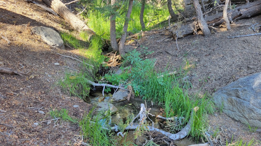
Water sources such as creeks, pipes, and springs are generally flowing well (see sample photos below and in prior Reports). Consequently in contrast to most recent years I am not reporting water flow details for specific locations at this time. Flow rates are of course now finally dropping, and some ephemeral water sources have recently dried. To date this summer has seen the most water on the mountain since 1998 (following the great El Niño winter of 1997/98).
Given the intensity of this past winter, hikers should expect to encounter new treefall hazards on trails. Trails are slowly being cleared, largely by volunteers, as described in Trail Conditions below.
Be rattlesnake aware. Southern Pacific Rattlesnakes Crotalus (oreganus) helleri are active on the trail system up to 9300 ft elevation (photo below). Above about 5000 ft, the venom of this rattlesnake species in the San Jacinto mountains is predominantly neurotoxic, almost always fatal for dogs and sometimes for humans (see my 2020 article here for further information). Devil’s Slide and lower Deer Springs trails, Suicide Rock, around Strawberry Cienega, and trails near Tahquitz Peak are common locations for sightings.
Black Mountain Road (4S01) was in its poorest condition for at least a decade this spring. The partial grading undertaken on 17th July has improved the situation somewhat, but it remains a bumpy drive. Forest Service roads Dark Canyon Road (4S02) and South Ridge Road (5S11) remain closed to vehicles. Other than Dark Canyon campground and the South Ridge yellow post sites, all Forest and State camping areas have reopened.
The annual maintenance closure of the Palm Springs Aerial Tramway is scheduled for 7th-31st August 2023, a month earlier than usual, as described here.
Due to major road work at the uppermost end of Fern Valley Road, Humber Park parking area will be completely closed to all traffic for two weeks in October 2023 (exact dates currently unknown). In general be prepared for possible disruption accessing trailheads around Idyllwild throughout August-October due to resurfacing work, expected on lower Saunders Meadow Road in August, North Circle and South Circle drives in August-September, and Fern Valley Road in September-October.

WEATHER
Although the middle of this week (15th-17th) may have above-average temperatures, cool and cloudy weather is again forecast starting around Saturday 19th, with tropical monsoonal conditions likely lasting for a week or more. Spin-off from Tropical Storm Hilary moving north along Baja California on 19th-21st may bring substantial tropical moisture to the San Jacinto mountains. The forecasts currently vary greatly regarding quantity of possible rainfall, depending on the exact track of the tropical storm, but could be at least an inch or two at mid elevations, with 4-7 inches possible in the high country. A south-easterly airflow following passage of the tropical storm may bring in monsoonal thunderstorms for several days continuing to at least 25th August.
Monsoonal thunderstorms on Sunday 13th August produced good rains east and west of the San Jacinto mountains, but the intense cells sadly bypassed Idyllwild and the high country. Saddle Junction (8100 ft) received 0.12 inch, with 0.08 inch at Wellman’s Cienega (9300 ft), but only 0.02 inch was recorded both near San Jacinto Peak (10,700 ft) and in Idyllwild (at 5550 ft).
At San Jacinto Peak (10,810ft/3295m) on Wednesday 16th August 2023 at 0825 the air temperature was 63.1°F (17°C), with a “windchill” temperature of 55.8°F (13°C), 52% relative humidity, and a very light ESE breeze sustained at 2 mph gusting to 4.7 mph.
At the Peak on Monday 14th August 2023 at 0740 the air temperature was 49.4°F (10°C), with a windchill temperature of 39.8°F (4°C), 70% relative humidity, and a gusty SE wind sustained at 10 mph gusting to 19.6 mph.
At the Peak on Friday 11th August 2023 at 0755 the air temperature was 46.4°F (8°C), with a “windchill” temperature of 42.3°F (6°C), 56% relative humidity, and a SSW breeze sustained at 2 mph gusting to 5.9 mph.

TRAIL CONDITIONS
The trail system is clear of snow. Despite my optimistic predictions earlier in the summer, no snow patches quite survived on or near the trail system into August, with the last few on the East Ridge of San Jacinto Peak finally melting in the last week of July. A couple of narrow icy snow patches remain in the upper reaches of the Snow Creek drainage.
Deer Springs Trail has about 15 significant treefall hazards. Little Round Valley is now completely clear of snow, water is flowing very well there and in all of the springs and creeks along the Deer Springs Trail route (sample photos in prior Report linked here).
Trails around the Skunk Cabbage and Tahquitz area meadows have some significant treefall hazards throughout. There are seven treefall hazards across the trails between Little Tahquitz Meadow and Chinquapin Flat and another two down on the trail south from Saddle Junction to Chinquapin Flat.
After three years of neglect by the Forest Service, Willow Creek Trail has finally had a continuous route cleared through by a combination of State Park workers and contractors plus volunteers from several organizations, including the Trail Report. In several areas the whitethorn trimming work has been done poorly and the trail remains scrappy, but at least it is readily passable (photo below). Of the 68 treefall hazards that were across the trail following the winter, about eight remain to be cut for the original course of the trail to be fully restored, but that is unlikely to happen anytime soon, if ever.
Fourteen treefall hazards from this past winter on South Ridge Trail (above the trailhead at the top of South Ridge Road) were removed by the Trail Report in May, and trail trimming on that section is undertaken regularly. South Ridge Road remains closed to vehicle traffic and is not expected to reopen until graded, possibly not until August. Eleven of 13 downed trees were removed by volunteers from the middle section of South Ridge Trail (between May Valley Road and the top of South Ridge Road) on 15th July.
Marion Mountain Trail has four notable new treefall hazards in the State Park (upper) half.
The Trail Report removed all 38 treefall hazards from Spitler Peak Trail between late May and early June this year, bringing the total removed to 85+ since July 2021. Several minor washouts from this past winter in the upper switchbacks have significantly impacted the tread in places; these are not problematic for hikers, but the trail is impassable to stock.
The PCT is clear of snow throughout the San Jacinto mountains but treefall hazards remain a problem in many places, most notably between Apache Peak and Red Tahquitz, where I counted 106 between Miles 169-175 in June 2023. Large downed trees make for especially slow-going around Miles 172-175 (a section severely burned in the July 2013 Mountain Fire).
The Caramba Trail from near Reeds Meadow through Laws Camp and on to Caramba, and the Cedar Trail from Willow Creek Trail to Laws, are euphemistically described by the Forest Service as “not maintained”. In reality both trails have been abandoned and functionally no longer exist. They are so heavily overgrown with dense whitethorn, which obscures dozens of downed trees, that I strongly advise hikers do not attempt to follow them (regardless of how much you may trust a certain app). An informal use trail to Laws is much more direct, well maintained, and avoids the challenging bushwhacking of the unmaintained trails (local Idyllwild hikers dubbed it the “King Trail” when I established the route in 2019). It leaves Willow Creek Trail exactly 1.0 mile from Saddle Junction, 0.46 mile from the Skunk Cabbage turning (trailhead at lat/long N 33.7796, W 116.6590). The route descends largely following established deer trails for 1.2 miles, meeting Willow Creek about 0.2 mile upstream from the site of the historic Laws Camp (the remains of which were destroyed by the 2013 Mountain Fire and subsequent flood and treefall damage). The 11 trees down on the King Trail after this winter were removed in June-July 2023. From Laws east to Caramba the route of the original Caramba Trail has been well-cairned by myself and others and can largely be followed with very careful route-finding. My May 2023 survey counted just over 100 trees down on this 2.1 miles of trail. It is especially obscure for the first 0.3 mile east of the Willow Creek crossing, becoming more obvious (but still subtle) as it descends towards Caramba. Very cautious navigation is advised throughout the area.
Seven Pines Trail is clear of treefall hazards for about three miles of its 3.7 miles length. The Trail Report has “adopted” Seven Pines Trail as a priority for maintenance work as the trail has had a disproportionate number of lost hiker rescues in the past decade. Since November 2021, 67 downed trees have been removed and almost the entire trail thoroughly trimmed and cleared. Nevertheless Seven Pines remains a genuine wilderness trail unlike the relatively wide, bare, and obvious routes of, for example, Devil’s Slide or Marion Mountain trails. Cautious navigation remains essential for those without considerable experience of hiking this trail.

While all time and labor is volunteered, the San Jacinto Trail Report uses small private donations to help cover operating costs. Every year has its unique challenges, and 2023 has been no exception. Your contribution keeps the Report available to all, free from advertising or paywalls, and independent from agencies. If you have found this Report useful, please consider using this link to the Donate page. Zelle, Venmo, and PayPal are all options. Thank you very much for your support.