The San Jacinto mountains remain in a protracted heatwave, along with much of the desert south-west. While local temperatures peaked last weekend – Idyllwild reached 99°F on Saturday 15th July surpassing the previous record high for that date by two degrees – temperatures above seasonal are forecast to persist until the end of July at least. At mid elevations (such as Idyllwild) daytime highs are expected to be several degrees above seasonal every day, with overnight lows generally 10-15°F above seasonal.
The highest elevations are equally impacted. Although an all-time record temperature is not now expected in the high country, by far the longest ever period of days >15°C (59°F) at San Jacinto Peak is likely, almost certainly of more than two weeks and potentially continuing into early August.
Fire risk is very high, as demonstrated by multiple significant fire starts in the grasslands of the nearby lowlands in the past week (described here). From San Jacinto Peak there was thankfully no visible sign of the Rabbit Fire by Monday 17th July, other than remnant smoke obscuring a very hazy Coachella Valley.
Hikers should be prepared for unseasonably hot weather in the high country, with temperatures well above seasonal at all times of day and at all elevations. Give considerable extra thought to route choice, start times, clothing, sun protection, and hydration requirements.
Hikers in summer should also always be prepared for rapidly changing weather conditions in the high country. Monsoon thunderstorms are a possibility, although storm probabilities are currently low for the foreseeable future. Lightning, brief but intense precipitation, and rapid temperature drops can occur in the high country even when such storms are not forecast for lower elevations.
The trail system is now clear of snow. A few snow patches remain in the most heavily drifted areas that traditionally melt late, notably the East Ridge of San Jacinto Peak.
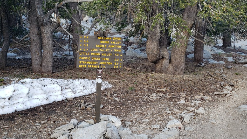
Daily survey hikes include a variety of routes to San Jacinto Peak multiple times per week, most recently on 17th, 19th, and 21st July, plus many other trails on intervening days. A sample of my recent weather observations from San Jacinto Peak is given in the Weather section below.
Currently perennial creeks, pipes, and springs are flowing well (e.g., see photos in the previous Report and below), as are most ephemeral springs and creeks. Consequently I am not reporting details for individual water sources at this time. Given recent temperatures and record low humidity, this situation may change soon. To date this summer has seen the most water on the mountain since 1998 (following the great El Niño winter of 1997/98).
Given the intensity of this past winter, hikers will encounter new treefall hazards on trails. Trails are steadily being cleared, largely by volunteers. Since the snow melted the Trail Report has cleared upper South Ridge and Spitler Peak trails (14 and 38 trees, respectively), the PCT between Saddle and Annie’s junctions (approx. PCT Miles 179-181, eight of nine trees), the informal trail from Willow Creek Trail to Laws (10 trees), and largely cleared Seven Pines Trail. Starting in June 39 trees – from an initial total of about 68 – were cut from Willow Creek Trail by various volunteer and state teams.
Be rattlesnake aware. Southern Pacific Rattlesnakes Crotalus (oreganus) helleri are now present on the trail system up to at least 8800 ft elevation, although observations so far this year have been infrequent. Above about 5000 ft, the venom of this rattlesnake species in these mountains is predominantly neurotoxic, typically fatal for dogs and sometimes for humans (see my 2020 article here for further information). Devil’s Slide and lower Deer Springs trails, Suicide Rock, around Strawberry Cienega, and trails near Tahquitz Peak are common locations for sightings, but rattlesnakes have been recorded up to 9300 ft, generally favoring sun-exposed rocky outcrops and slopes.
Black Mountain Road (4S01) was in its poorest condition for at least a decade this spring. The mediocre grading job undertaken on 17th July improved the situation, but the Road remains lumpy and a high clearance vehicle is still recommended. Forest Service roads Dark Canyon Road (4S02) and South Ridge Road (5S11) remain closed to vehicles. Other than Dark Canyon, all Forest and State campgrounds have now reopened.
Tahquitz Peak fire lookout reopened for the season on 4th June. Black Mountain fire lookout will reopen for the season on Sunday 23rd July following (partial) grading of Black Mountain Road.
The annual maintenance closure of the Palm Springs Aerial Tramway is scheduled for 7th-31st August 2023, a month earlier than usual.
Due to major road work at the uppermost end of Fern Valley Road, Humber Park parking area will be completely closed to all traffic, including cyclists and pedestrians, for two weeks in October (exact dates TBD). In general be prepared for disruption accessing trailheads around Idyllwild throughout August-October due to resurfacing work on North Circle Drive, South Circle Drive, and Fern Valley Road.
WEATHER
Six consecutive months of below average temperatures to start 2023 ended abruptly at the beginning of July, and this month has seen two significant heatwaves already. The most recent of these is continuing at present and has been unusually protracted. At the elevation of Idyllwild daytime highs are forecast to average several degrees above seasonal every day into the last week of July. As is increasingly the trend in the San Jacinto mountains, the overnight “low” temperatures in particular will be as much as 15°F above seasonal especially at mid elevations.
The highest elevations will not be spared, with temperatures well above average for July for at least two, possibly three weeks, likely into early August. At San Jacinto Peak temperatures at or above 59°F (15°C) are predicted for 12-15 days; most years experience fewer than five days that warm at the Peak all summer.
There is no significant new precipitation in the forecasts, with no sign of monsoonal rains reaching the San Jacinto mountains before August. Despite the wet winter and cool first half of the year, vegetation moisture levels have rapidly dropped below average (per data in NWS San Diego video linked here). The fire danger locally is very high.
At San Jacinto Peak (10,810ft/3295m) on Friday 21st July 2023 at 0720 the air temperature was 62.6°F (17°C), with a “windchill” temperature of 59.7°F (15°C), 34% relative humidity, and a warm ESE wind sustained at 4 mph gusting to 7.6 mph.
At the Peak on Wednesday 19th July 2023 at 0645 the air temperature was 55.9°F (13°C), with a “windchill” temperature of 52.7°F (12°C), 46% relative humidity, and a light WSW wind sustained at 3 mph gusting to 7.0 mph.
At the Peak on Monday 17th July 2023 at 0710 the air temperature was 57.4°F (14°C), with a “windchill” temperature of 52.2°F (11°C), 54% relative humidity, and a pleasantly cool SSE wind sustained at 10 mph gusting to 19.2 mph.
At the Peak on Friday 14th July 2023 at 0705 the air temperature was 58.5°F (15°C), with no observable windchill, 34% relative humidity, and completely calm wind conditions (extremely rare at the Peak).
At the Peak on Friday 7th July 2023 at 0750 the air temperature was 52.7°F (12°C), with a “windchill” temperature of 46.3°F (8°C), 4.8% relative humidity, and a light but steady due West wind sustained at 11 mph gusting to 14.7 mph. This average relative humidity measurement (which briefly dropped as low as 4.2%) is the lowest ever reliably recorded at San Jacinto Peak, breaking the record of 5% set just two days earlier. Prior to 2023, I had only recorded RH as low as 7% on three occasions.
TRAIL CONDITIONS
The trail system is now clear of snow. Snow cover averages about 5% around San Jacinto Peak, but with no significant snow patches on the trail routes up to the Peak. Snow cover remains about 15% on the East Ridge of the Peak, but the trail up that flank is functionally clear of snow.
Deer Springs Trail is now clear of snow, but has about 15 significant treefall hazards. Little Round Valley is now clear of snow. Water is flowing very well there and in all of the springs and creeks along the Deer Springs Trail route.
Trails around the Skunk Cabbage and Tahquitz area meadows have significant treefall hazards throughout. There are seven treefall hazards across the trails between Little Tahquitz Meadow and Chinquapin Flat, four major trees down across Willow Creek Trail between Saddle Junction and the Skunk Cabbage Meadow junction, and another four down on the trail south from Saddle Junction to Chinquapin Flat.
The Peak Trail is now clear of snow. The East Ridge Trail remains partly obscured under about 15% snow cover, but the remaining snow is heavily drifted and initially melted very unevenly forming “sun cups” (photo in prior Report linked here).
Fourteen treefall hazards from this past winter on South Ridge Trail (above the trailhead at the top of South Ridge Road) were removed by the Trail Report in May, and trail trimming on that section is undertaken regularly. South Ridge Road remains closed to vehicle traffic and is not expected to reopen until graded, possibly not until August. Eleven of 13 downed trees were removed by volunteers from the middle section of South Ridge Trail (between May Valley Road and the top of South Ridge Road) on 15th July.
Marion Mountain Trail is clear of snow but there are four notable new treefall hazards in the State Park (upper) half.
Willow Creek Trail was a slow, messy hike for a couple of miles due to treefall hazards and whitethorn overgrowth, but thanks to the work of volunteers the situation has slowly improved since May. As of 21st July 2023, about 29 treefall hazards remained across the trail, many of which are large and some are challenging to hike around (or over). There is only one large tree down between Saddle Junction and the Skunk Cabbage Meadow junction, and then a further 25 trees down on the next 1.5 mile Forest Service section until the State Park boundary. Only three trees remain down on the State Park section of trail up to Hidden Divide. The trail section with the most (18) trees down – between the Willow Creek crossing and the State Park boundary – is also disappearing under thick whitethorn. The considerable amount of work that Bill Rhoads and I undertook to clear whitethorn along this trail in 2020 was not completely in vain and parts of the trail would have functionally disappeared by now otherwise. The State Park has done an excellent job of trimming and clearing the trail on their section, with 90% of the whitethorn cut back in recent weeks, with just a few significant overgrown patches remaining up high near the Divide.
The Trail Report removed all 38 treefall hazards from Spitler Peak Trail between late May and early June this year, bringing the total removed to 85+ since July 2021. Several minor washouts from this past winter in the upper switchbacks have significantly impacted the tread in places; these are not problematic for hikers, but the trail is impassable to stock.
The PCT is now clear of snow throughout the San Jacinto mountains. Treefall hazards are a problem in many places but most notably between Apache Peak and Red Tahquitz, where I counted 106 between Miles 169-175 in June 2023. Large downed trees make for especially slow-going around Miles 172-175 (a section severely burned in the 2013 Mountain Fire).
Trails clear of both snow and treefall hazards include Black Mountain Trail, Ernie Maxwell Trail, Devil’s Slide Trail, and the Wellman Trail.
The Caramba Trail from near Reeds Meadow through Laws Camp and on to Caramba, and the Cedar Trail from Willow Creek Trail to Laws, are euphemistically described by the Forest Service as “not maintained”. In reality both trails have been abandoned and no longer exist. They are so heavily overgrown with dense whitethorn, which obscures dozens of downed trees, that I strongly advise hikers do not attempt to follow them (regardless of how much you may trust a certain app). An informal use trail to Laws is much more direct, well maintained by the Trail Report, and avoids the challenging bushwhacking of the unmaintained trails (local Idyllwild hikers dubbed it the “King Trail” when I established the route in 2019). It leaves Willow Creek Trail exactly 1.0 mile from Saddle Junction, 0.46 mile from the Skunk Cabbage turning (trailhead at lat/long N 33.7796, W 116.6590). The route descends largely following established deer trails for 1.2 miles, meeting Willow Creek about 0.2 mile upstream from the site of the historic Laws Camp (the remains of which were destroyed by the 2013 Mountain Fire and subsequent flood and treefall damage). The 11 trees down on the King Trail after this winter were removed in June-July 2023. From Laws east to Caramba the route of the original Caramba Trail has been well-cairned by myself and others and can largely be followed with very careful route-finding. My May 2023 survey counted just over 100 trees down on this 2.1 miles of trail. It is especially obscure for the first 0.3 mile east of the Willow Creek crossing, becoming more obvious (but still subtle) as it descends towards Caramba. Very cautious navigation is advised throughout the area.
Seven Pines Trail is clear of snow. The crossing of the very swollen North Fork of the San Jacinto River at 1.5 miles (just after the State Park boundary) currently requires considerable caution. The Trail Report has “adopted” Seven Pines Trail as a priority for maintenance work as the trail has had a disproportionate number of lost hiker rescues in the past decade. Since November 2021, 67 downed trees have been removed and almost the entire trail thoroughly trimmed and cleared. Nevertheless Seven Pines remains a genuine wilderness trail unlike the relatively wide, bare, and obvious routes of, for example, Devil’s Slide or Marion Mountain trails. Cautious navigation remains essential for those without considerable experience of hiking this trail.


While all time and labor is volunteered, the San Jacinto Trail Report uses small private donations to help cover operating costs. Every year seems to have its unique challenges, and 2023 has been no exception. Your contribution keeps the Report available to all, free from advertising or paywalls, and independent from agencies. If you have found this Report useful, please consider using this link to the Donate page. Zelle, Venmo, and PayPal are all options. Thank you very much for your support.